Attachment 7 - Construction Impact Assessment & Tree Management Plan
A detailed arborist report assessing the impact of construction on existing trees and providing management recommendations.
167, 169 & 171 Island Hwy, View Royal, BC
Construction Impact Assessment & Tree Management Plan
PREPARED FOR: GT Mann Contracting Ltd. 1551 Broadmead Ave Victoria, BC V8P 2V1
PREPARED BY: Talmack Urban Forestry Consultants Ltd. Graham Mackenzie – Consulting Arborist ISA Certified # PN-0428A Tree Risk Assessment Qualified
DATE OF ISSUANCE: June 18, 2021 Amended May 19, 2022
CONTENTS
- INTRODUCTION ............................................................................................................................ 1
- TREE INVENTORY METHODOLOGY ........................................................................................... 1
- EXECUTIVE SUMMARY ................................................................................................................ 1
- TREE INVENTORY DEFINITIONS ................................................................................................. 2
- SITE INFORMATION & PROJECT UNDERSTANDING ................................................................ 9
- FIELD OBSERVATIONS ................................................................................................................ 9
- TREE RISK ASSESSMENT ........................................................................................................... 9
- CONSTRUCTION IMPACT ASSESSMENT ................................................................................. 10 8.1. Retention and Removal of Municipal Trees .................................................................................. 10 8.2. retention and removal of private offsite trees ............................................................................... 10 8.3. retention and removal of onsite trees ........................................................................................... 11 8.4. tree replacement ........................................................................................................................... 11
- IMPACT MITIGATION .................................................................................................................. 11
- DISCLOSURE STATEMENT ........................................................................................................ 13
- IN CLOSING ................................................................................................................................. 14
- REFERENCES ............................................................................................................................. 15
TABLES Table 1. Tree Inventory ........................................................................................................................................ 4
APPENDICES Appendix A Tree Management Plan (T1) Appendix B Site Photographs
1. INTRODUCTION
Talmack Urban Forestry Consultants was asked to complete a tree inventory, construction impact assessment and management plan for the trees at the following proposed project:
- Site: 167, 169 & 171 Island Hwy,
- Municipality: View Royal, BC
- Client Name: GTMann Contracting Ltd.
- Dates of Site Visit: May 20, 2021
- Site Conditions: 3 urban lots. No ongoing construction activity. Gradual increase in elevation from South to North.
- Weather During Site Visit: Clear and sunny
The purpose of this report is to address requirements of the Town of View Royal Tree Preservation Bylaw No. 695. The construction impact assessment section of this report (section 8), is based on plans reviewed to date, including the Architectural site, foundation, floor & Elevation plans (May 18, 2021) - Prepared by Urban West Architecture. At this time we have not reviewed a civil servicing plan (showing proposed underground utility connection locations), or a landscape plan.
2. TREE INVENTORY METHODOLOGY
Prior to our site visit, we were provided with surveyed tree locations from the project surveyor (Wey Mayenburg Land Surveying Inc.). For the purpose of this report, the size, health, and structural condition of trees was documented. For ease of identification in the field, numerated metal tags were attached to the lower trunks of onsite trees. Trees located on neighbouring properties, the municipal frontage or in areas where access was restricted, were not tagged (identified as NT 1 – NT 11). Each tree was visually examined on a limited visual assessment basis (level 1), in accordance with Tree Risk Assessment Qualification (TRAQ) methods (Dunster et al. 2017) and ISA Best Management Practices.
3. EXECUTIVE SUMMARY
Based on review of the architectural site, foundation, floor & Elevation plans provided, we anticipate that the majority of the onsite trees and some trees on neighbouring properties located close to the property line will require removal. The tree management plan (T1) in appendix A) shows trees that we anticipate will require removal and those that we feel can be retained, providing their critical root zones can be adequately protected during construction. In order to complete the excavation for the underground portion of the building and retain trees on neighbouring properties it may require shoring techniques to minimise the requirements for any cut slopes. This will depend on the soil conditions, the depth of excavation and the requirements from the geotechnical engineer.
4. TREE INVENTORY DEFINITIONS
Tag: Tree identification number on a metal tag attached to tree with nail or wire, generally at eye level. Trees on municipal or neighboring properties are not tagged.
NT: No tag due to inaccessibility or ownership by municipality or neighbour.
DBH: Diameter at breast height – diameter of trunk, measured in centimetres at 1.4m above ground level. For trees on a slope, it is taken at the average point between the high and low side of the slope. * Measured over ivy ~ Approximate due to inaccessibility or on neighbouring property
Dripline: Indicates the radius of the crown spread measured in metres to the dripline of the longest limbs.
Relative Tolerance Rating: Relative tolerance of the tree species to construction related impacts such as root pruning, crown pruning, soil compaction, hydrology changes, grade changes, and other soil disturbance. This rating does not take into account individual tree characteristics, such as health and vigour. Three ratings are assigned based on our knowledge and experience with the tree species: Poor (P), Moderate (M) or Good (G).
Critical Root Zone: A calculated radial measurement in metres from the trunk of the tree. It is the optimal size of tree protection zone and is calculated by multiplying the DBH of the tree by 10, 12 or 15 depending on the tree’s Relative Tolerance Rating. This methodology is based on the methodology used by Nelda Matheny and James R. Clark in their book “Trees and Development: A Technical Guide to Preservation of Trees During Land Development.”
- 15 x DBH = Poor Tolerance of Construction
- 12 x DBH = Moderate
- 10 x DBH = Good
To calculate the critical root zone, the DBH of multiple stems is considered the sum of 100% of the diameter of the largest stem and 60% of the diameter of the next two largest stems. It should be noted that these measures are solely mathematical calculations that do not consider factors such as restricted root growth, limited soil volumes, age, crown spread, health, or structure (such as a lean).
Health Condition:
- Poor - significant signs of visible stress and/or decline that threaten the long-term survival of the specimen
- Fair - signs of stress
- Good - no visible signs of significant stress and/or only minor aesthetic issues
Structural Condition:
- Poor - Structural defects that have been in place for a long period of time to the point that mitigation measures are limited
- Fair - Structural concerns that are possible to mitigate through pruning
- Good - No visible or only minor structural flaws that require no to very little pruning
Suitability ratings are described as follows:
Rating: Suitable.
- A tree with no visible or minor health or structural defects, is tolerant to changes to the growing environment and is a possible candidate for retention provided that the critical root zone can be adequately protected.
Rating: Conditional.
- A tree with good health but is a species with a poor tolerance to changes to its growing environment or has a structural defect(s) that would require that certain measures be implemented, in order to consider it suitable for retention (ie. retain with other codominant tree(s), structural pruning, mulching, supplementary watering, etc.)
Rating: Unsuitable.
- A tree with poor health, a major structural defect (that cannot be mitigated using ANSI A300 standards), or a species with a poor tolerance to construction impacts, and unlikely to survive long term (in the context of the proposed land use changes).
Retention Status:
- Remove - Not possible to retain given proposed construction plans
- Retain - It is possible to retain this tree in the long-term given the proposed plans and information available. This is assuming our recommended mitigation measures are followed
- Retain * - See report for more information regarding potential impacts
Table 1. Tree Inventory
| Prev Tag. | Tag or ID # | Bylaw protected ? | Common Name | Botanical Name | dbh (cm) | CRZ r (m) | Ht (m) | Dripline diameter (m) | Health Condition | Structural Condition | Relative tolerance | General field observations/remarks |
|---|---|---|---|---|---|---|---|---|---|---|---|---|
| 473 | yes | Grand fir | Abies grandis | 53 | 6.5 | 20 | 6 | Fair/good | Fair | Poor | Codomimant leaders form at 15 meters above grade, small deadwood in canopy. | |
| 869 | 474 | yes | Bigleaf maple | Acer macrophyllum | 51, 18 | 7 | 20 | 9 | Fair/good | Fair/poor | Moderate | Secondary stem forms at .5m above grade - narrow angle of attachment, fruiting bodies between stem union. |
| 866 | yes | Western redcedar | Thuja plicata | 14 - 38 | 4 | 10 | 8 | Fair | Fair/good | Moderate | Hedge row consisting of 15 Western redcedar amd 24 Leyland Cypress. | |
| M1 | yes | Garry oak | Quercus garryanna | 6 | 1 | 5 | 1 | Good | Fair/good | Good | Juvenile tree, codomimant leaders form at 3m above grade. Hasn’t fully established - some root plate movement. | |
| M2 | yes | Garry oak | Quercus garryanna | 5 | 1 | 5 | 1 | Good | Good | Good | Juvenile tree, hasn’t fully established - some root plate movement. | |
| M3 | yes | Linden | Tilia cordata | 18 | 2 | 10 | 6 | Good | Fair | Moderate | Included bark at brands unions. | |
| M4 | yes | Eddies white wonder dogwood | Cornus nuttalli x florida | 7 | 1 | 4 | 3 | Fair/poor | Fair | Moderate | Health stress - sparse crown. | |
| M5 | yes | Linden | Tilia cordata | 18 | 2 | 10 | 6 | Good | Fair | Moderate | Included bark at brands unions. | |
| 873 | 475 | yes | Purple leaf plum | Prunus cerasifera | 26, 14, 9 | 3 | 8 | 8 | Good | Fair | Good | Growing within close proximity to existing retaining wall on North side, previous stem failures. |
| 876 | 476 | yes | Bigleaf maple | Acer macrophyllum | 52 | 6 | 15 | 12 | Good | Fair | Moderate | Codomimant leaders form at 8m above grade - included and active union, injured surface root. |
| 477 | yes | Garry oak | Quercus garryanna | 64 | 6 | 20 | 18 | Good | Fair/good | Good | Balanced crown, some endweighted limbs. | |
| 478 | yes | Douglas-fir | Pseudotsuga menziesii | 60 | 7 | 20 | 10 | Fair/poor | Fair | Poor | Health stress - twig amd branch dieback, surface rooted. | |
| 479 | yes | Arbutus | Arbutus menziesii | 24, 14, 13 | 4 | 10 | 8 | Fair/good | Fair | Poor | Multiple stems cluster, suppressed by 478 - asymmetric crown on West side due to shading. | |
| 480 | yes | Western red cedar | Thuja plicata | 50 | 5 | 20 | 8 | Poor | Fair/good | Moderate | Declining health - top dieback - 50%lcr. | |
| NT1 | yes | Spruce | Picea species | 25 | 3 | 15 | 5 | Fair | Fair/poor | Poor | Deflected top, secondary leader. | |
| 481 | yes | Golden Chain Tree | Laburnum | 16, 16, 15 | 3 | 10 | 7 | Fair | Fair/poor | Moderate | Deadwood, included bark in unions. | |
| 482 | yes | Plum | Prunus species | 28, 25, 20, 18, 16, ~15, ~15, ~12, ~10 | 5 | 12 | 14 | Fair | Fair/poor | Good | Multiple stems, some leaning, deadwood, ivy on trunks, included bark. | |
| 483 | yes | Cherry | Prunus species | 44 | 4 | 20 | 12 | Fair/poor | Fair/poor | Moderate | Health stress, deadwood, tortrix infestation, leans east, supported by 484. | |
| 484 | yes | Grand fir | Abies grandis | 52 | 6 | 30 | 11 | Fair | Fair | Poor | Lower trunk wound. | |
| OS1 | yes | Grand fir | Abies grandis | 37 | 4 | 20 | 8 | Fair | Fair | Poor | Surface roots, sparse foliage lower crown. | |
| OS2 | yes | Douglas-fir | Pseudotsuga menziesii | 32 | 4 | 20 | 9 | Fair | Fair | Poor | Deadwood lower crown, branch failures (hangers). | |
| 485 | yes | Katsura | Cercidiphyllum japonica | 13, 13, 12, 12, 11 | 3 | 10 | 8 | Good | Fair/poor | Good | Multiple stems with narrow attachments arising in close proximity, included bark. | |
| NT2 | no | Red Alder | Unus rubra | 29 | 3.5 | 15 | 10 | Good | Fair | Poor | Large surface root. | |
| NT3 | no | Plum | Prunus species | 14, 14, 9 | 3 | 5 | 5 | Fair | Fair/poor | Moderate | Large surface root, topping/heading cuts historically. | |
| 486 | yes | Leyland Cypress | Cupressus x leylandii | 46, 44, 36 | 4 | 20 | 12 | Good | Fair/poor | Good | Tridominant, included bark. | |
| 487 | yes | Deodar Cedar | Cedrus deodara | 42 | 4 | 25 | 10 | Good | Fair | Moderate | Some yellowing/browning foliage, canopy competition with 488. | |
| 488 | yes | Leyland Cypress | Cupressus x leylandii | 50 | 5 | 20 | 10 | Good | Fair | Good | East end of hedge row, asymmetric crown due to competition. | |
| OS3 | yes | Bigleaf maple | Acer macrophyllum | 50, 25 | 6 | 20 | 14 | Poor | Poor | Moderate | Extensive decay, undermined, large epicormic growth, supported by hedge row. Wildlife tree sign affixed. | |
| NT4 | no | Leyland Cypress | Cupressus x leylandii | 25 | 3 | 15 | 7 | Good | Fair | Good | Part of hedge row, asymmetric due to competition. | |
| 489 | yes | Leyland Cypress | Cupressus x leylandii | 38, 24 | 4 | 20 | 9 | Good | Fair/poor | Good | Codominant, included bark primary union. | |
| OS4 | yes | European Hornbeam | Carpinus betulus | 57, 33 at 0.75m | 6 | 15 | 12 | Good | Fair | Moderate | Multiple stems arising from close points of attachment characteristic of species. | |
| NT5 | no | Leyland Cypress | Cupressus x leylandii | 29 | 3 | 15 | 7 | Good | Fair | Good | Part of hedge row, asymmetric due to competition. | |
| 490 | yes | Leyland Cypress | Cupressus x leylandii | 36 | 3.5 | 15 | 8 | Good | Fair | Good | Part of hedge row, asymmetric due to competition. | |
| 491 | yes | Leyland Cypress | Cupressus x leylandii | 34 | 3.5 | 15 | 8 | Good | Fair | Good | Part of hedge row, asymmetric due to competition. | |
| 492 | yes | Leyland Cypress | Cupressus x leylandii | 37 | 3.5 | 15 | 8 | Good | Fair | Good | Part of hedge row, asymmetric due to competition. | |
| 493 | yes | Leyland Cypress | Cupressus x leylandii | 27, 17 | 3.5 | 15 | 10 | Good | Fair/poor | Good | Part of hedge row, asymmetric due to competition. Codominant, included bark. | |
| 495 | yes | Leyland Cypress | Cupressus x leylandii | 39, 22 | 4 | 15 | 12 | Good | Fair/poor | Good | Part of hedge row, asymmetric due to competition. Codominant, included bark. | |
| NT6 | no | Leyland Cypress | Cupressus x leylandii | 24 | 3 | 15 | 8 | Good | Fair | Good | Part of hedge row, asymmetric due to competition. | |
| 495 | yes | Leyland Cypress | Cupressus x leylandii | 29, 25, 22 | 4 | 15 | 9 | Good | Fair/poor | Good | Part of hedge row, asymmetric due to competition. Tridominant, included bark, roots heaving driveway? | |
| 496 | yes | Leyland Cypress | Cupressus x leylandii | 28, 25 | 4 | 15 | 8 | Fair | Fair/poor | Good | Part of hedge row, asymmetric due to competition. Structure suggests previous topping. Codominant, included bark. | |
| NT7 | no | Leyland Cypress | Cupressus x leylandii | 26 | 3 | 10 | 7 | Fair/poor | Fair/poor | Good | Part of hedge row, asymmetric due to competition. Topped historically. | |
| 497 | yes | Leyland Cypress | Cupressus x leylandii | 38 | 3 | 15 | 7 | Good | Fair/poor | Good | Part of hedge row, asymmetric due to competition. Topped historically. | |
| 498 | yes | Leyland Cypress | Cupressus x leylandii | 32 | 3 | 15 | 7 | Good | Fair/poor | Good | Part of hedge row, asymmetric due to competition. Topped historically. | |
| 499 | yes | Leyland Cypress | Cupressus x leylandii | 25, 16 | 3 | 15 | 7 | Good | Fair/poor | Good | Part of hedge row, asymmetric due to competition. Topped historically. | |
| 500 | yes | Leyland Cypress | Cupressus x leylandii | 32 | 3 | 15 | 8 | Good | Fair/poor | Good | Part of hedge row, asymmetric due to competition. Topped historically. | |
| NT8 | no | Leyland Cypress | Cupressus x leylandii | 27 | 3 | 15 | 7 | Good | Fair/poor | Good | Part of hedge row, asymmetric due to competition. Topped historically. | |
| NT9 | no | Leyland Cypress | Cupressus x leylandii | 28 | 3 | 15 | 7 | Good | Fair/poor | Good | Part of hedge row, asymmetric due to competition. Topped historically. | |
| 436 | yes | Leyland Cypress | Cupressus x leylandii | 30 | 3 | 15 | 8 | Good | Fair/poor | Good | Part of hedge row, asymmetric due to competition. Topped historically. | |
| NT10 | no | Leyland Cypress | Cupressus x leylandii | 29 | 3 | 15 | 8 | Good | Fair/poor | Good | Part of hedge row, asymmetric due to competition. Topped historically. | |
| 437 | yes | Leyland Cypress | Cupressus x leylandii | 38 | 4 | 15 | 8 | Good | Fair/poor | Good | Part of hedge row, asymmetric due to competition. Topped historically. | |
| 438 | yes | Leyland Cypress | Cupressus x leylandii | 40 | 4 | 15 | 8 | Good | Fair/poor | Good | North end of hedge row. Topped historically, long seam of included bark in attachment between codominant leaders. | |
| NT11 | yes | Leyland Cypress | Cupressus x leylandii | 22avg. | 3 | 15 | 7 | Fair | Fair/poor | Good | Seven stems in hedge row, asymmetric due to competition. Topped historically. |
*CRZ calculated above and drawn as follows on Tree Management Plan (T1): CRZ + 0.5 * d.b.h. (drawn from the center of the stem)
5. SITE INFORMATION & PROJECT UNDERSTANDING
The development site consists of three urban lots (167, 169 & 171 Island Hwy), in View Royal, B.C., which have existing residences situated on the lots. It is our understanding that the proposal is to remove the existing residences and create a multi-unit building with underground parking.
Below is a general observation of the tree resource, as it appeared at the time of our site visit:
6. FIELD OBSERVATIONS
The onsite tree resource consists of a mixture of native and ornamental species. The site is bordered by municipal parkland to the South and East and a commercial property to the West.
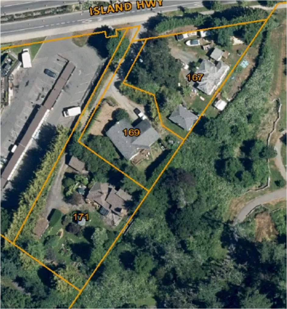
figure 1: Site context air photo: The boundaries of the subject site is outlined in Yellow.
7. TREE RISK ASSESSMENT
During our May 20, 2021 site visit and in conjunction with the tree inventory, onsite trees were assessed for risk, on a limited visual assessment basis (level 1), and in the context of the existing land uses. The time frame used for the purpose of our assessment is one year (from the date of the May 20, 2021 tree inventory). Unless otherwise noted herein, we did not conduct a detailed (level 2) or advanced (level 3) risk assessment, such as resistograph testing, increment core sampling, aerial examinations, or subsurface root/root collar examinations.
Existing Land Uses
We did not observe any trees that were deemed to be moderate, high or extreme risk (in the context of the existing land uses, that would require hazard abatement to eliminate present and/or future risks (within a 1-year timeframe). Targets considered during this TRAQ assessment include: occupants of the existing residence (constant use), occupants of vehicles travelling on Island Hwy (frequent use), pedestrians travelling along existing sidewalks (frequent use), hydro lines (constant use).
8. CONSTRUCTION IMPACT ASSESSMENT
8.1. RETENTION AND REMOVAL OF MUNICIPAL TREES
The following municipal trees (indicated by ID #) are located where it is possible for retention providing that its critical root zones are adequately protected during construction. The project arborist must be onsite to supervise and excavation or fill placement required within its critical root zone (shown on the tree management plan (T1) in appendix A):
Retain and protect 1 municipal trees
- M1 – M5
*Note that the municipality will need to provide consent, prior the removal of any trees that are located on Municipal property.
8.2. RETENTION AND REMOVAL OF PRIVATE OFFSITE TREES
The following private offsite tree (indicated by ID #) are located where it will be heavily impacted by excavation and blasting required to construct the foundation of the proposed residence and is proposed for removal:
Remove 3 trees located on neighboring property.
- OS1 – OS3
*Prior written consent from the neighbouring owner is required prior to the removal of any trees located on neignbouring properties. Unsurveyed trees may require surveying to verify ownership.
The following Private offsite tree (indicated by ID #) are located where it is possible for retention providing that its critical root zones are adequately protected during construction. The project arborist must be onsite to supervise and excavation or fill placement required within its critical root zone (shown on the tree management plan (T1) in appendix A):
Retain and protect 1 offsite tree
- OS4
Document Images
(1)