Attachment 8 Project Sustainability Checklist
A completed municipal checklist evaluating the economic, environmental, and social sustainability components of the proposed multi-family development.
THETIS NEIGHBOURHOOD
OBJECTIVE LU10
Preserve the recreational and environmental integrity of Thetis Lake Regional Park and adjoining natural areas.
POLICIES
LU10.1 Thetis Lake Regional Park Continue to support the preservation of Thetis Lake Regional Park as an important recreational amenity and significant natural resource.
Support planning initiatives that:
- Improve local and regional access and connections to the park.
- Expand the park boundaries.
- Enhance the recreational amenities within the park without compromising critical habitat or sensitive species.
LU10.2 Urban Containment Boundary Support the intentions of the regional Urban Containment Boundary and View Royal’s Urban Containment Boundary by promoting conservation and discouraging development in the natural and rural areas north of Thetis Lake Regional Park.
Any new development proposed for north of Thetis Lake Regional Park should be carefully reviewed to consider the following:
- How it fits within the Regional Growth Strategy and the Development Framework set out in the OCP.
- Potential impacts on the natural environment.
- Infrastructure and servicing costs and impacts.
- Uses and densities appropriate for a service and access limited area.
- Opportunities for rural uses such as agriculture.
- Conservation easements and park land dedication.
- Public access to lakes, streams, creeks, and lookouts.
WILFERT NEIGHBOURHOOD
OBJECTIVE LU11
Support the revitalization of the Wilfert Neighbourhood and View Royal’s western gateway through land use intensification and improvements along the Island Highway.
POLICIES
LU11.1 Western Gateway Community Corridor Support the development of the Western Gateway Community Corridor as a high intensity mixed-use area, with an emphasis on commercial uses and high-quality urban design.
Development in the Western Gateway Community Corridor should be carefully reviewed to consider the following:
- High intensity commercial and mixed uses that support an attractive street-level environment and multimodal transportation.
- Quality of the built environment.
- Quantity and location of parking to ensure that street frontages are people-friendly and designed for the comfort of those arriving by foot, bike, and transit, as well as by car. Specifically, buildings should be designed closer the Island Highway and include sidewalk entries. Parking should be located behind the building, away from the Island Highway, or in underground garages and parking structures.
- Housing densities and design that are compatible with high intensity commercial development.
- Adjacencies and interfaces with Millstream Creek, trails and established residential areas.
- Roadway, sidewalk, and other public space enhancements that will create a safe and enjoyable street-level environment, and a sense of place and continuity along the Community Corridor.
- Increasing parkland along Millstream Creek and providing pedestrian connections.
ACTION LU10 Explore developing a food security strategy that includes the identification of suitable sites for agriculture, urban farming, community gardens and farmers’ markets.
2 | TRANSPORTATION AND MOBILITY
OVERVIEW
Transportation is one of the major contributors to greenhouse gas emissions (GHG) in View Royal. View Royal can effectively reduce its GHG emissions and meet ambitious targets by advancing actions that will support alternative ways of getting around and electrifying transportation. This chapter sets out goals, objectives, policies and implementing actions for developing a multi-modal transportation system in View Royal to support compact and sustainable development, provide greater transportation choice, and reduce car use and greenhouse gas emissions (GHGs).
GOALS
- Confirm View Royal as an environmentally responsible community committed to taking action to reduce greenhouse gas emissions from transportation.
- Create an inclusive community that provides housing and transportation options, services and facilities for families and individuals of diverse backgrounds, cultures, ages, and economic means.
- Recognize the regional role of the community as a link in major transportation and environmental systems and cooperate with other municipalities and governments to address regional issues while also protecting local values and promoting long-term sustainability.
VIEW ROYAL TODAY
In the past, View Royal functioned as a suburb of Victoria. Today, residents often must travel long distances by car to go to work and to access goods, services, and other amenities. The Town’s proximity to regional trails and transit provides excellent opportunities for connected, active, and multi-modal transportation. There is an opportunity for View Royal to provide more transportation options that better accommodate community needs and support community wellbeing. View Royal’s Transportation Master Plan prioritizes pedestrian, active transportation, and public transit, with private vehicles as the lowest priority. Objectives, policies, and actions in this section support an intentional shift toward investing in a low carbon future.
EXISTING TRANSPORTATION INFRASTRUCTURE
View Royal’s location between the region’s Urban Core and West Shore communities has resulted in the Town being well served by transportation infrastructure. The Town boasts good access to regional trails, transit routes, the E&N railway corridor, highways, and arterial and local roads.
WALKING AND CYCLING
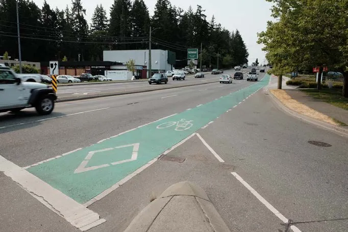
Over the past decade, View Royal has made significant progress in developing continuous and safe pedestrian and bicycle routes within and through the community. This includes introducing traffic calming improvements on busy roads, improving crossings near schools, providing new sidewalks, creating trail connections, and adding bike lanes on commuter routes. Despite this progress and the Town’s ongoing work to enhance the safety and comfort of cyclists and pedestrians through prioritized improvements, many neighbourhoods in View Royal are yet to have adequate connections. The lack of a safe and inviting connection across the Trans-Canada Highway causes fragmentation that affects the entire community. The Casino Highway Improvement Project and Island Highway Improvement Project have closed some significant gaps in cycling infrastructure in the Town.
REGIONAL TRAILS
The Galloping Goose Trail and several regional bike routes connect View Royal locally and regionally. These routes are widely used by bike commuters and for recreation purposes. The Galloping Goose extends east-west through View Royal via Colwood from Sooke and connects to Victoria and the Peninsula trails that extend past Sidney. Another regional trail, the E&N Rail Trail, connects View Royal on the East and West. In addition to the E&N trail, the CRD adopted a Regional Pedestrian & Cycling Master Plan (PCMP) in 2016.
BUS AND RAPID TRANSIT
Several bus routes provide transit service in View Royal, which is expanding. The Town works with BC Transit to plan appropriate bus routes and bus stop locations. BC Transit also provides feedback on anticipated service needs and routing for proposed developments in View Royal. A goal of BC Transit is to ensure that transit stops are spaced along a transit corridor at appropriate intervals between 300m – 500m (about a 10-minute walk). The existing transit stops provide excellent coverage based on these parameters.
In response to BC Transit’s long-term Transit Future Plan in 2014-15, transit services made seasonal service changes. The new program increases service to tourism destinations, improves system reliability, and reduced post-secondary and secondary school services. Changes were also made to Route 53 - Colwood / Langford via Atkins Road based on community input.
E&N CORRIDOR
The existence of the E&N railway corridor presents a unique opportunity to connect multiple communities in the CRD and Vancouver Island. The corridor runs from Victoria, through the West Shore, all the way to Courtenay, connecting southern Vancouver Island with up-island communities. View Royal is one of the many communities that advocates for preserving the E&N corridor to accommodate future transportation options that could carry passengers travelling for employment, education, shopping, and excursion purposes. Although there is currently no formal planning or funding for this project, View Royal joins communities such as Langford and Colwood in identifying commuter rail service on the E&N as a part of its long-term vision. The Town will continue to lobby other levels of government to make commuter rail a regional priority.
MAJOR ROADS
The Town is traversed by two major east-west roads – Highway 1 (Trans-Canada Highway) and the Island Highway. While residents of View Royal travel on these roads, most users live beyond the Town’s boundaries. These two high-volume highways have separated View Royal’s neighbourhoods from each other. In particular, the Trans-Canada Highway separates neighbourhoods to the north of the highway from those to the south. On weekdays, “rush hour” traffic begins piling up on the Island Highway. This daily gridlock dramatically slows down local access to homes and businesses and creates significant noise, air, and visual impacts.
Other major roads in View Royal include Admirals, Helmcken Road, Six Mile Road, Watkiss Way and Burnside Road. All these roads experience high volumes of traffic at peak times. Some are busy for most of the day. Traffic and noise generated by these roadways often detract from the ambience of adjacent neighbourhoods or inhibit comfortable social interactions on the bordering sidewalks and properties. Like the Island Highway and Trans-Canada Highway, major roads can be barriers between and within neighbourhoods. View Royal will continue to prioritize the needs of residents and local businesses over the needs of commuter traffic.
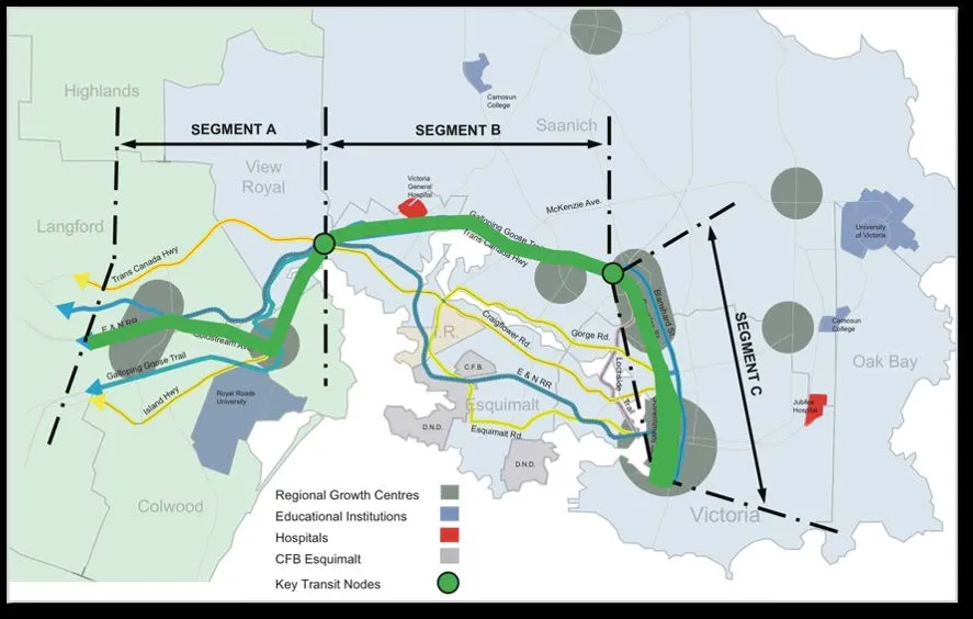
MAJOR TRANSPORTATION ROUTES
| Major Roads | Regional Trails |
|---|---|
| Trans-Canada Highway (Highway 1) | Galloping Goose Trail |
| Watkiss Way | E & N Rail Trail |
| Burnside Road | |
| Six Mile Road | Rapid Transit and Commuter Rail |
| Helmcken Road | Regional Rapid Transit Alignment (Planned) |
| Admirals Road | E & N Rail Alignment (Future Opportunity) |
TRANSPORTATION PLANS
TRANSPORTATION MASTER PLAN
The View Royal Transportation Master Plan was adopted in 2016 to guide transportation decisions and investments in the Town. The Master Plan includes an analysis of existing conditions, recommendations for improvements and implementation strategies. Overall, the Master Plan establishes a strong direction to prioritize walking, biking, and transit; reduce automobile dependency; and improve safety and comfort on local roadways.
Recommendations in the Master Plan include:
- Improving bike and pedestrian infrastructure.
- Working with BC Transit to improve transit service through View Royal.
- Encouraging the development of zoning bylaws that promote mixed-use, transit-oriented development. Exploring possible diversion routes to support calm and efficient traffic through View Royal.
CRD TRANSPORTATION PLANS
The TravelChoices Strategy was adopted by the CRD as the region’s long-range transportation planning framework. The Strategy aims to promote a balanced, sustainable, and affordable transportation system and achieve the goals and targets identified by the Regional Growth Strategy (RGS).
The Strategy’s broad vision is to “significantly increase the proportion of people walking, cycling, using transit, ride-sharing or using other alternatives to driving alone.” More specific elements of the strategy seek to:
- Integrate land use and transportation policies.
- Enhance alternatives to driving alone.
- Manage transportation systems.
- Manage transportation investments.
In 2016, the CRD developed a Regional Pedestrian and Cycling Master Plan. The Plan builds on the RGS and sets out specific priorities for improvements to the regional pedestrian and cycling networks. View Royal will continue to partner in regional transportation investments.
PLANNING FOR CHANGE
Transportation planning is entering a new era. The wide-reaching and long-term impacts of transportation decisions are better understood, and communities actively seek new solutions to their transport and mobility needs. Instead of being limited by a primary goal of moving people and goods as efficiently as possible, planners, engineers and communities are now working within the context of climate change and reducing GHG emissions. View Royal is supportive of non-motorized and electric options, other transportation modes, investment in safer walkways/ streets, and promotion of healthy lifestyles.
Sustainable transportation planning is closely tied to land use. Sustainable settlement patterns are designed for proximity to where people live, work and play, which reduces the need for private automobiles to get around. In turn, land use decisions today should ensure that new development is directed to areas well-served by transportation infrastructure and that population densities provide the ridership numbers required to make transit service financially viable. This is especially important in areas surrounding transit stops.
Concentrating new growth in the neighbourhood centres and community corridors will reduce the need to travel long distances and provide population densities necessary for further investments in frequent transit service. Targeted infill development will support transportation improvements in established neighbourhoods. The Transportation Master Plan supports planning land use in harmony with transportation and sets out strategies for improving transit, cycling, and walking networks. View Royal’s Active Transportation Network Plan and Community Climate Action Strategy will guide a viable, multimodal transportation system that will meet the evolving needs of residents, businesses, and visitors.
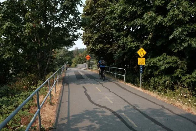
Bike path, Source: James Davison