Town of View Royal Urban Forest Strategy 2025
A comprehensive 20-year framework to guide the management of View Royal’s urban forest, setting goals and strategies for climate resilience and community health.
TOWN OF VIEW ROYAL Urban Forest Strategy 2025
Plan at a Glance
This is the Town of View Royal’s first Urban Forest Strategy (UFS). The UFS establishes a comprehensive, 20-year framework to guide the management of View Royal’s urban forest. The UFS reflects the Town’s commitment to enhancing community climate resilience, supporting the urban forest, enhancing public health and wellbeing, and protecting trees and native biodiversity.
View Royal’s Urban Forest Vision
In 2055, our Town's urban forest is celebrated for its diverse, mature trees and interconnected green spaces. It provides vital habitat for native plants, pollinators, and wildlife, mitigates the impacts of climate change and enhances community resilience, health, and well-being. By protecting the existing urban forest and making space for new trees, we have enhanced and expanded our urban forest and strengthened our sense of place. We are stewards of our environment, and the trees we plant today will benefit our community for generations.
Urban Forest Value
- $10 M: Value of our urban forest
- $184,000: Urban forest program budget
Tree Inventory
- 1,200: boulevard trees inventoried
- 33%/25%: inventoried trees are maple / red maple
Canopy Cover
- 29%: Urban canopy cover (2023)
- 59%: of urban canopy is on private land
- 30%: Canopy Cover Target (2045)
Survey Results
- 85%: Were concerned about tree loss
- 80%: Want canopy cover to increase
Strategic Framework
The strategic framework consists of:
- Vision: What we want
- 5 Goals: Goal 1. Plan, Goal 2. Manage, Goal 3. Maintain, Goal 4. Protect, Goal 5. Partner.
- 14 Strategies: How we get there
- 51 Actions
14 Strategies
- 1.1 Ensure planting standards support long-term tree growth
- 1.2 Ensure land use planning supports the urban forest
- 1.3 Ensure rates of tree planting support net new outcomes
- 1.4 Consider equity and community needs through program decision-making.
- 2.1 Improve urban forest governance
- 2.2 Prioritize program monitoring and reporting
- 2.3 Sustainably resource urban forest management and the implementation of this Strategy.
- 3.1 Use best practices and industry benchmarks in the Town’s maintenance regime
- 3.2 Maintain forested areas to a reasonable standard of care
- 4.1 Enhance regulatory tools and processes to achieve the right balance between tree protection and community growth.
- 4.2 Support the resilience of both View Royal as a community and its urban forest.
- 5.1 Build relationships with Host Nations and Indigenous Peoples living in View Royal
- 5.2 Build community knowledge of and participation in urban forest management
- 5.3 Develop strategic partnerships
19 Core Actions
Are essential to program performance and no net loss of canopy cover.
- Update View Royal’s Subdivision and Development Servicing Bylaw and planting standards to enhance conditions for street trees
- Adopt and revise OCP policy supporting the urban forest and UFS that provides enhanced direction on the handling of View Royal’s urban forest
- Review View Royal’s Zoning Bylaw to ensure performance criteria contribute to the Town’s canopy cover target.
- Municipal tree planting targeting 50 trees per year in parks and boulevards
- Establish an adopt-a-tree program
- Establish dedicated tree maintenance and planting budgets within parks to increase tree longevity.
- Establish an interdepartmental Urban Forestry working group
- Establish and maintain a GIS-based boulevard tree inventory
- Produce a new urban tree canopy dataset
- Produce a State of the Urban Forest report on a five-year interval
- Establish a Town arborist or urban forester position within Parks to broadly enhance urban forest outcomes
- Access external funding opportunities to support tree planting
- Establish a Wildfire Hazard Development Permit Area (DPA)
- Review the Town’s Natural Watercourse and Shoreline Areas, and Sensitive Terrestrial Ecosystem DPAs
- Develop a Terms of Reference for arborist reports and tree surveys
- Explore the potential of a Landscaping Bylaw
- Prepare a biannual newsletter to communicate key urban forestry messages, updates, and progress on UFS implementation
- Continue to offer View Royal’s Resident Tree Planting Program and expand it if demand outpaces current program capacity
- Actively participate in and support initiatives that utilize the Capital Regional District’s (CRD) network of urban forestry professionals
Acknowledgements
Land Acknowledgement The Town of View Royal acknowledges with respect that it is on the unceded traditional territories of the Lekwungen peoples, known today as the Esquimalt and Songhees Nations, and that their historic connections to these lands continue to this day.
Acknowledgement We are grateful to all those who contributed to shaping the Town of View Royal’s Urban Forest Strategy. The Strategy was developed with the support of Diamond Head Consulting.
Town of View Royal: Ivan Leung; Laura Busby Diamond Head Consulting: Shane Hunt; Tyler Searls; Marco Sanelli; Jodi Crawford; Vlad Romanescu; Amelia Needoba
Glossary
- 3-30-300 Rule: A guidelines for urban forestry to ensure equitable access to greenspace. The rule states that at least 3 trees should be visible from each home, each neighbourhood should have 30 per cent (or more) canopy cover, and each home should be within 300 m of a park or other greenspace.
- 30-20-10 Rule: A diversity standard for urban forests: no more than 30% of trees should come from one family, 20% from one genus, or 10% from one species. This helps reduce the risk of pests and diseases wiping out large portions of the tree population.
- Asset Management (Natural Assets): The practice of managing trees, forests, and other natural features as part of a municipality’s infrastructure system, recognizing them as assets that provide services like stormwater control and climate resilience.
- Biodiversity: The variety of living things in an ecosystem, including plants, animals, fungi, and microorganisms, and their relationships with each other. Higher biodiversity makes ecosystems healthier and more resilient.
- Canopy Cover: The percentage of land area covered by the leaves or needles of trees when viewed from above. It is a common way to measure the extent of an urban forest.
- Community Wildfire Resilience Plan: A municipal plan that identifies wildfire risks and actions to reduce them, such as vegetation management, emergency preparedness, and public education.
- DBH (Diameter at Breast Height): A standard way to measure tree size: the diameter of a tree’s trunk measured at 1.3 metres (about chest height) above the ground.
- Ecosystem Services: The environmental, social and economic benefits that natural systems provide, such as shade, clean air, stormwater management, flood control, habitat for wildlife, and improved human health.
- Evapotranspiration: The combined processes of evaporation and transpiration by which water moves from the land and vegetation into the atmosphere. It is a key part of the water cycle and affects how much moisture is available for trees and ecosystems.
- FireSmart: A provincial program in British Columbia that helps communities and property owners reduce the risk of wildfire through landscaping, building practices, and education.
- GIS (Geographic Information System): A digital mapping system used to collect, manage, and analyze spatial data. In urban forestry, it is used to map trees, canopy cover, and ecological features.
- Greenfield Development: Construction on land that has not been previously built on, often natural or agricultural land.
- i-Tree: A software tool used for urban forestry analysis and benefits assessments. It can be used to calculate the environmental and economic value of trees, such as air quality improvements, carbon storage, and stormwater management.
- Invasive Species: Plants, animals, or insects that are not native to an area and spread quickly, often harming native species and ecosystems. Common examples in View Royal include English ivy and Scotch broom.
- Urban Forest: All trees, vegetation, and forested areas within View Royal, including those in parks, along streets, in private yards, and in natural areas.
- Urban Heat Island (UHI) Effect: The tendency for urban areas with lots of pavement and buildings to become much hotter than surrounding green areas.
- Windthrow: The uprooting or breaking of trees due to strong winds.
Table of Contents
- Introduction & Overview ............................................................................ 2 1.1 Welcome 1.2 Plan Purpose 1.3 Structure of the Strategy 1.4 What is the Urban Forest? 1.5 Why is the Urban Forest Important? 1.7 Policy Context 1.8 Urban Forest Report Card
- View Royal’s Urban Forest .......................................................................... 18
- Looking Ahead ............................................................................................... 38 3.1 Where we are going 3.2 What We Heard
- Action Plan ..................................................................................................... 45
- Implementation Plan ..................................................................................... 65 References ......................................................................................................... 75 Appendix ............................................................................................................ 78
Figures
- Figure 1. Urban to rural gradient showing the range of tree assets in View Royal ................. 3
- Figure 2. The many benefits provided by View Royal’s urban forest ....................................... 4
- Figure 3. Land surface temperature across the Town during an extreme heat event (06-25-22) ............ 5
- Figure 4. Health benefits of urban trees adapted from Urban Trees and Human Health: A Scoping Review. ................. 6
- Figure 5. The proportion of canopy cover within the Town’s Urban Containment Boundary by ownership type in 2023 ................. 10
- Figure 6. View Royal’s Policy Context ................................................................................... 12
- Figure 7. Canopy cover refers to the leafy upper part of trees when viewed from above (right) ................. 24
- Figure 8. Town-wide canopy cover in 2023 with the UCB ..................................................... 25
- Figure 9. Canopy cover by neighbourhood in 2023 .............................................................. 26
- Figure 10. Citywide and UCB canopy cover comparison with municipalities in the region ....... 27
- Figure 11. Canopy cover loss within the Urban Containment Boundary from 2001 - 2023 ....... 28
- Figure 12. Proportion of View Royal’s urban (UCB) canopy cover and land area by ownership type (left), and canopy cover within that ownership type (right) in 2023 ................. 29
- Figure 13. Proportion of View Royal’s urban (UCB) canopy cover and land area by land use (left), and canopy cover within that land use (right) in 2023 ................. 30
- Figure 14. Low Canopy Hotspot (LCH) mapping within View Royal ...................................... 31
- Figure 15. The relative proportion of genera included in the Town’s inventory of street trees (1222) ... 32
- Figure 16. Successional stage of View Royal’s urban forested areas (right) ......................... 34
- Figure 17. Climate change projections in the CRD ............................................................... 39
- Figure 18. View Royal canopy cover pathways: Canopy growth, net neutral, and status quo ... 45
Tables
- Table 1. Summary of ecosystem service values for View Royal’s UCB using i-Tree Canopy (2023) ... 7
- Table 2. Monitoring framework to track the implementation of the Urban Forest Strategy ...... 61
1. Introduction & Overview
1.1 Welcome
View Royal values its trees. Our community consists of a mosaic of urbanized spaces, interwoven with natural landscapes — Douglas-fir forests, Garry oak meadows, and forested shorelines. These are places home to a rich diversity of species. Our natural spaces and features enhance our built environment and provide essential spaces for recreation, leisure and ecological health.
The urban forest has long been a priority in View Royal. The 2011 Official Community Plan (OCP) committed to maintaining a healthy urban forest by encouraging the retention of trees and ecological features, expanding tree canopy cover and enhancing biodiversity and habitat. Despite these commitments, new and evolving challenges, such as climate change, urban intensification, and declining forest health, threaten the quality and extent of the urban forest.
To address these growing threats and to enhance community resilience, a renewed approach is needed — one that strengthens our management of the urban forest and supports its long-term sustainability to secure benefits to the community.
1.2 Plan Purpose
The Urban Forest Strategy (UFS) sets a clear, coordinated direction for managing View Royal’s urban forest over the next 20 years. Its goal is to ensure the continued delivery of ecological, social, and health benefits provided by the urban forest.
Effective urban forest management is inherently interdisciplinary, involving multiple departments and interested parties in the community. Planning requires thoughtful integration of diverse interests, values, and technical expertise. This strategy is designed to provide that integration — balancing environmental protection, community needs, and the realities of urban development.
A 20-year horizon allows space for transformative but sustainable urban forest planning, while scheduled five-year reviews will ensure the strategy remains adaptive and responsive to evolving challenges and best practices.
By planning strategically, the Town can:
- Identify and track emerging issues in urban forest management,
- Establish organizational priorities in managing the urban forest,
- Support urban forest monitoring with reliable data and tools,
- Expand and enhance access to urban nature,
- Improve alignment between financial planning and operational needs,
- Inform data-driven policy development and decision-making, and
- Strengthen community outreach, education, and stewardship.
1.3 Structure of the Strategy
The UFS is organized into five sections:
- Introduction and Overview: introduces the context, purpose, and benefits of urban forest management in View Royal.
- View Royal’s Urban Forest: summarizes the current condition of the urban forest, including its composition, trends, and pressures.
- Our Program: describes the Town’s existing urban forest programs and regulatory framework.
- The Path Forward: Identifies the key challenges and community input that have informed this Strategy, and introduces the strategic framework.
- Action and Monitoring Plan: details the actions, targets, and indicators that will guide implementation over the next 20 years.
1.4 What is the Urban Forest?
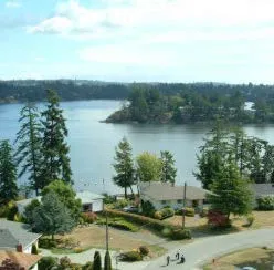
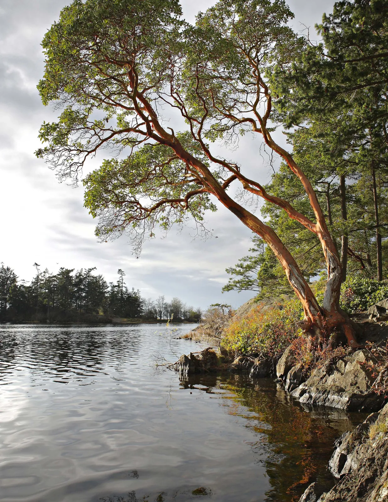
View Royal’s urban forest includes all trees and forested landscapes within the Town’s boundaries—those in public parks, along streets, in private yards, and within natural areas. It encompasses both planted and naturally occurring vegetation, and extends across the urban core to Thetis Lake, and Mill Hill Regional Parks, and the Town’s rural edges (Figure 1).
The urban forest is more than trees alone. It includes the living (biotic), non-living (abiotic), and cultural elements that shape our landscapes—soils, understory vegetation, hydrology, and the relationships between people and place. Together, these features form a complex urban ecological system embedded in the urban environment.
Figure 1. Urban to rural gradient showing the range of tree assets in View Royal
1.5 Why is the Urban Forest Important?
Urban forests are an essential part of a livable, resilient and healthy urban environment. The benefits trees provide are often referred to as ‘ecosystem services’. Examples of benefits include:
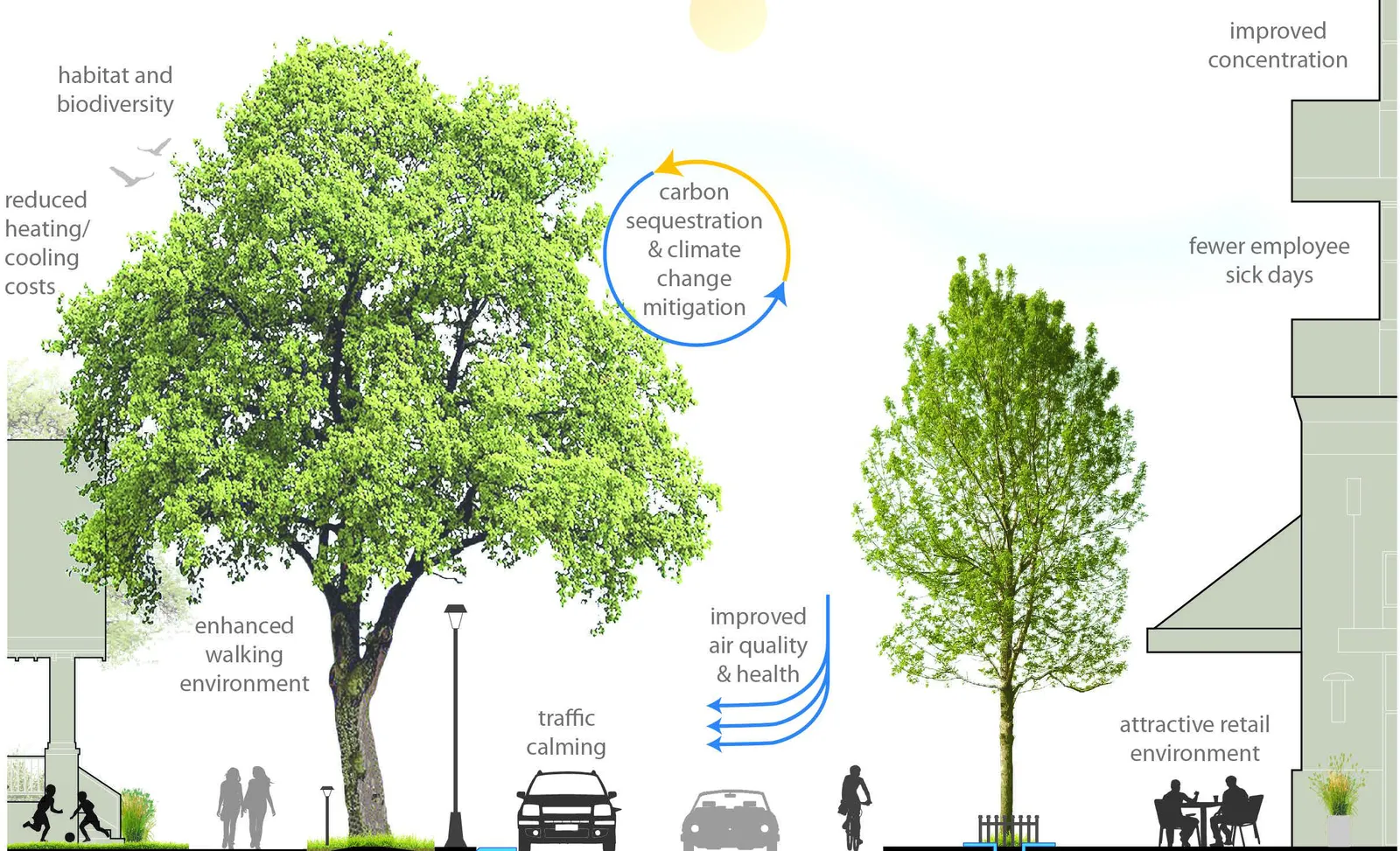
Climate adaptation and mitigation Trees regulate temperatures through shade and reduce storm and flood impacts. They are also important carbon sinks, sequestering and storing atmospheric carbon.
Clean air and water Leaves intercept or absorb pollutants like carbon monoxide, nitrogen dioxide, and particulates. Leaves and root systems also attenuate and filter rainwater and stormwater runoff, improving water quality before it enters our waterways.
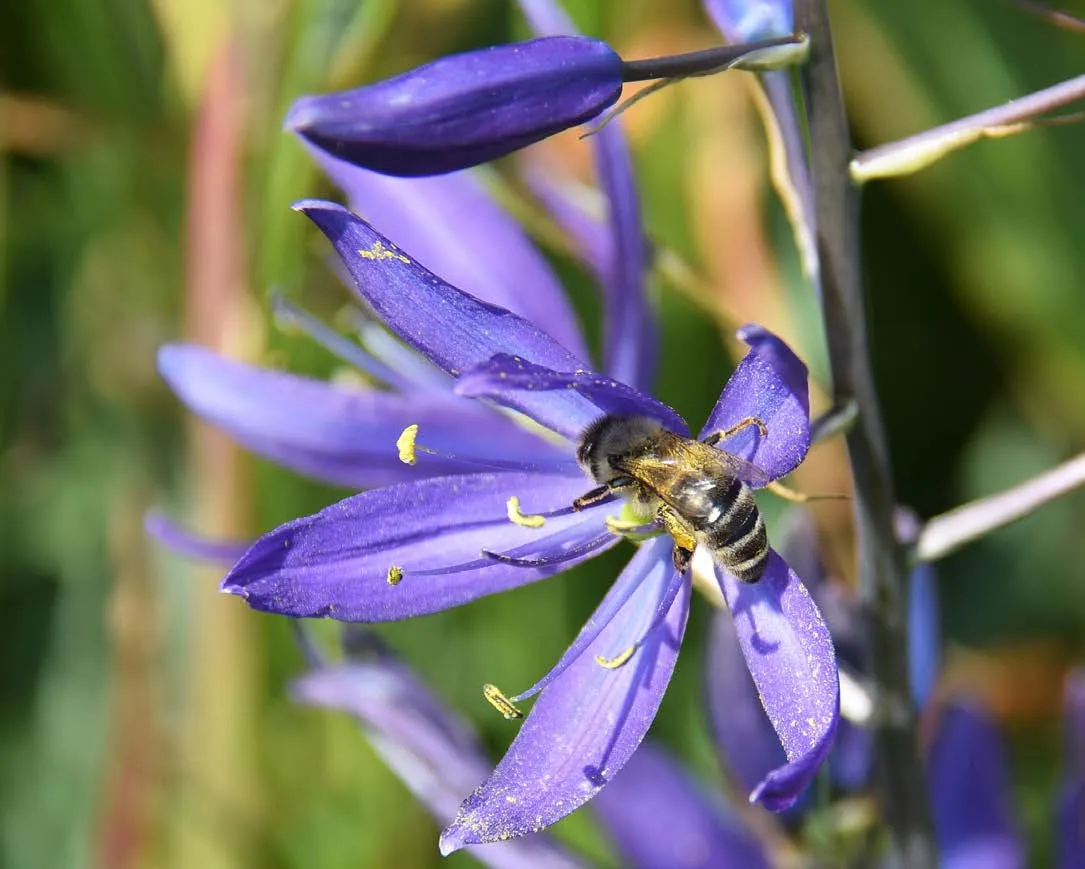
Habitat and biodiversity Urban forests support a wide range of plant, animal, fungal, and microbial life, benefiting both human and animal residents.
Improving human health Exposure to greenery reduces stress, improves work performance, boosts creativity, and aids recovery in hospitals. Schools with more trees and shrubs visible from classroom windows have been found to achieve higher test scores and graduation rates. Access to parks or natural areas increases physical activity levels.
Economic value Trees stimulate the local economy by attracting people to commercial districts, resulting in increased spending and longer stays. Areas with abundant tree cover often have higher property values.
Resources Trees provide resources for cultural, social, and economic uses, including food, medicines or materials like timber, firewood or bark for weaving.
Figure 2. The many benefits provided by View Royal’s urban forest
Extreme Heat
The urban forest also plays a critical role in protecting communities from the effects of extreme heat. By providing shade and releasing moisture into the air, they cool their environments. Urban areas with higher tree cover are better able to moderate extreme temperatures, reducing the risk of heat-related illnesses and mortality. This benefit was underscored during British Columbia’s 2021 heat dome, which caused over 800 fatalities. A 2022 report to the Chief Coroner of BC identified low canopy cover as a contributing factor to this loss of life.
In contrast, areas with limited tree cover are often dominated by hard surfaces—such as pavement and rooftops—that absorb and retain heat throughout the day, then release it slowly at night, leading to elevated ambient temperatures and prolonged heat exposure. In View Royal, the effects of urban heat can be seen in a land surface temperature map captured on a hot summer day (Figure 3). This map highlights the cooling influence of forested areas like Thetis Lake Regional Park, shown in blue. In some cases, surface temperatures in these areas can be as much as 15°C cooler than the hottest urbanized areas in Town, shown in red.
Figure 3. Land surface temperature across the Town during an extreme heat event (06-25-22)
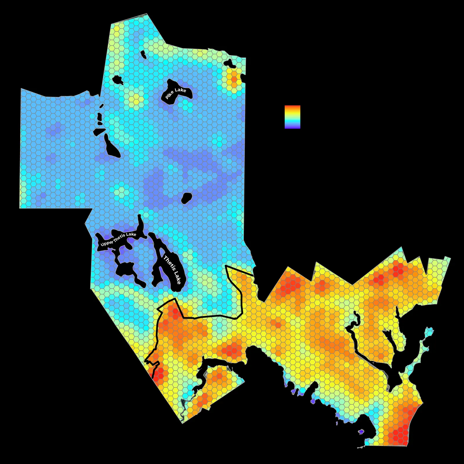
Figure 4. Health benefits of urban trees adapted from Urban Trees and Human Health: A Scoping Review.