Supporting Material - Vancouver Island crashes map
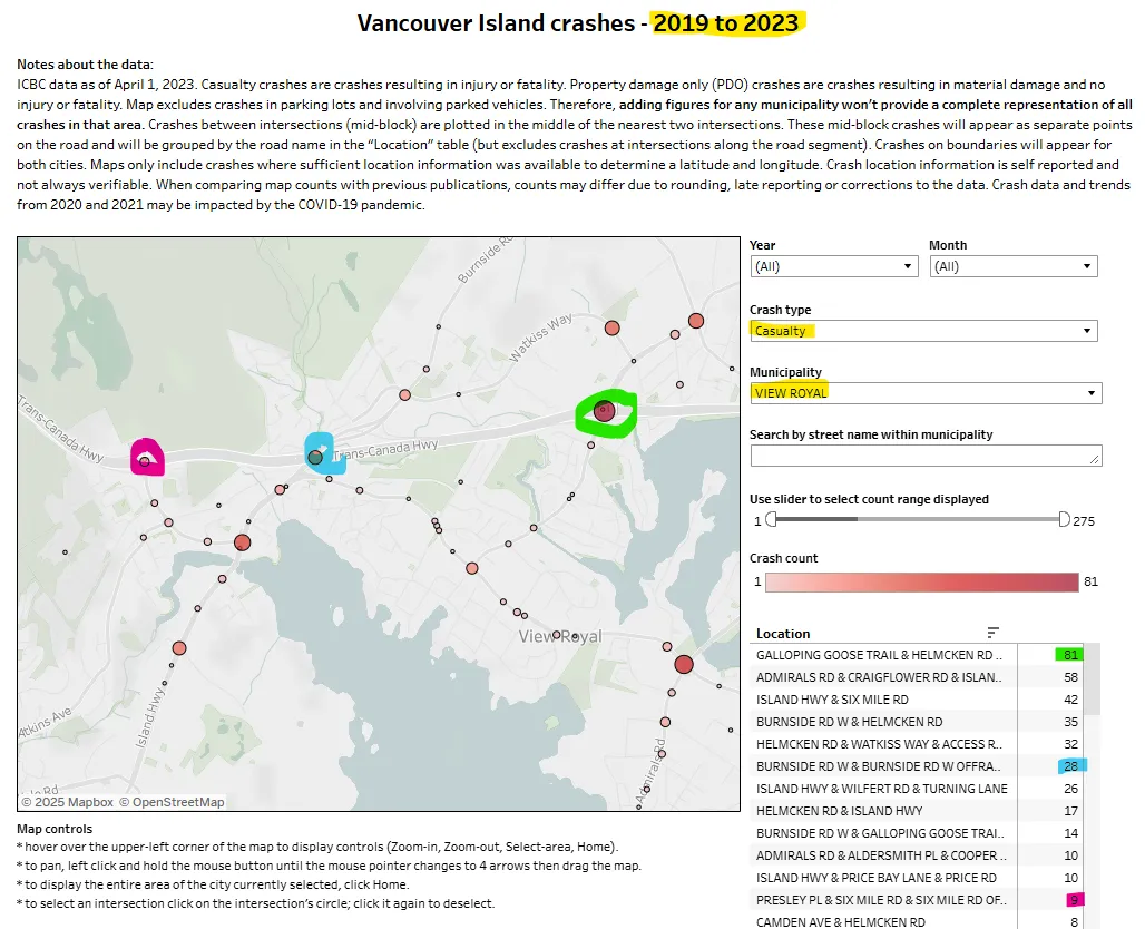
A heat map of traffic accidents in the View Royal area between 2019 and 2023.
Vancouver Island crashes - 2019 to 2023
Notes about the data: ICBC data as of April 1, 2023. Casualty crashes are crashes resulting in injury or fatality. Property damage only (PDO) crashes are crashes resulting in material damage and no injury or fatality. Map excludes crashes in parking lots and involving parked vehicles. Therefore, adding figures for any municipality won't provide a complete representation of all crashes in that area. Crashes between intersections (mid-block) are plotted in the middle of the nearest two intersections. These mid-block crashes will appear as separate points on the road and will be grouped by the road name in the "Location" table (but excludes crashes at intersections along the road segment). Crashes on boundaries will appear for both cities. Maps only include crashes where sufficient location information was available to determine a latitude and longitude. Crash location information is self reported and not always verifiable. When comparing map counts with previous publications, counts may differ due to rounding, late reporting or corrections to the data. Crash data and trends from 2020 and 2021 may be impacted by the COVID-19 pandemic.
Dashboard Filters
- Year: (All)
- Month: (All)
- Crash type: Casualty
- Municipality: VIEW ROYAL
- Use slider to select count range displayed: 1 to 275
- Crash count range: 1 to 81
Location
| Location | Crash count |
|---|---|
| GALLOPING GOOSE TRAIL & HELMCKEN RD .. | 81 |
| ADMIRALS RD & CRAIGFLOWER RD & ISLAN.. | 58 |
| ISLAND HWY & SIX MILE RD | 42 |
| BURNSIDE RD W & HELMCKEN RD | 35 |
| HELMCKEN RD & WATKISS WAY & ACCESS R.. | 32 |
| BURNSIDE RD W & BURNSIDE RD W OFFRA.. | 28 |
| ISLAND HWY & WILFERT RD & TURNING LANE | 26 |
| HELMCKEN RD & ISLAND HWY | 17 |
| BURNSIDE RD W & GALLOPING GOOSE TRAI.. | 14 |
| ADMIRALS RD & ALDERSMITH PL & COOPER.. | 10 |
| ISLAND HWY & PRICE BAY LANE & PRICE RD | 10 |
| PRESLEY PL & SIX MILE RD & SIX MILE RD OF.. | 9 |
| CAMDEN AVE & HELMCKEN RD | 8 |
Map controls
- hover over the upper-left corner of the map to display controls (Zoom-in, Zoom-out, Select-area, Home).
- to pan, left click and hold the mouse button until the mouse pointer changes to 4 arrows then drag the map.
- to display the entire area of the city currently selected, click Home.
- to select an intersection click on the intersection's circle; click it again to deselect.