TOWN OF VIEW ROYAL PUBLIC HEARING REPORT
Staff report summarizing the intent of OCP Bylaw No. 996 and Zoning Bylaw No. 997 to reduce a proposed park triangle due to a construction error.
TOWN OF VIEW ROYAL PUBLIC HEARING REPORT
TO: Mayor and Council
DATE: May 9, 2018
FROM: Jeff Chow, MCIP, RPP, Senior Planner
HEARING: May 15, 2018
FILE Nos: 3440-20-2017/02, 3360-20-2017/04
Official Community Plan Bylaw No. 811, 2011 Amendment Bylaw No. 996, 2018 and Zoning Bylaw No. 900, 2014 Amendment Bylaw No. 997, 2018 - Lot A, Plan Tuzo Court
RECOMMENDATION:
THAT the report dated May 9, 2018 from the Senior Planner titled “Official Community Plan Bylaw No. 811, 2011 Amendment Bylaw No. 996, 2018 and Zoning Bylaw No. 900, 2014 Amendment Bylaw No. 997, 2018 - Lot A, Plan Tuzo Court” be received for information.
CHIEF ADMINISTRATIVE OFFICER’S COMMENTS:
I concur with the recommendation.
DIRECTOR OF DEVELOPMENT SERVICES’ COMMENTS:
I concur with the recommendation.
PURPOSE:
To present material previously reviewed by Council to summarize the intent of Official Community Plan Bylaw No. 811, 2011 Amendment Bylaw No. 996, 2018 and Zoning Bylaw No. 900, 2014 Amendment Bylaw No. 997, 2018.
BACKGROUND:
Phase 7 of the Thetis Vale Phase subdivision is a 4.3ha site located on the east slope of Mill Hill between Mill Hill Regional Park and Trans-Canada Highway. It was rezoned in 2014 to facilitate a 36–lot subdivision with 40% of the site (totaling 1.9ha) preserved as park as shown in Figure 1.
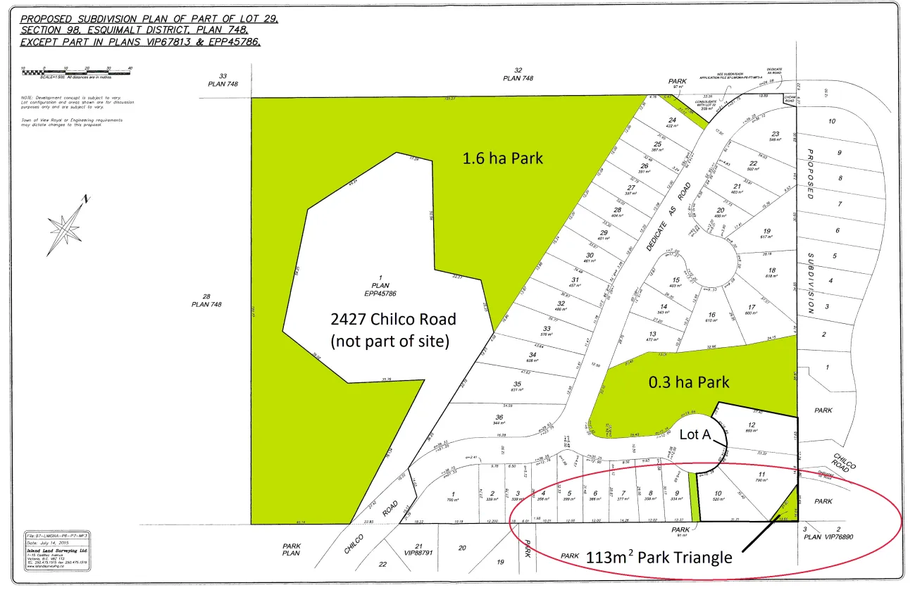
Figure 1. Thetis Vale Phase 7 – as originally proposed with 113m² park triangle
The 2110m² subject property (Lot A, Plan EPP55112) is the last phase of the subdivision and the intent was to subdivide it into three lots with a 113m² park triangle as shown in Figure 1. The area of the proposed lots is designated as “Residential” in the Official Community Plan and zoned CD-16: Mill Hill Residential Comprehensive Development. The 113m² proposed park triangle is designated as “Parks, Open Space, Recreation” in the Official Community Plan and is zoned P-3: Park and Recreation Use.
PROPOSAL:
The purpose of the two bylaws is to amend the Official Community Plan land use designation and the zoning designation to reduce the proposed park triangle from 113m² to 6.8m² as shown in Figure 2.
The steep site was blasted and graded to create level yard areas on proposed Lots B and C. The applicant explains that the retaining walls for Proposed Lot B were inadvertently constructed within the original proposed park triangle. The bylaws would reduce the size of the park triangle so that the retaining wall would be on private property.
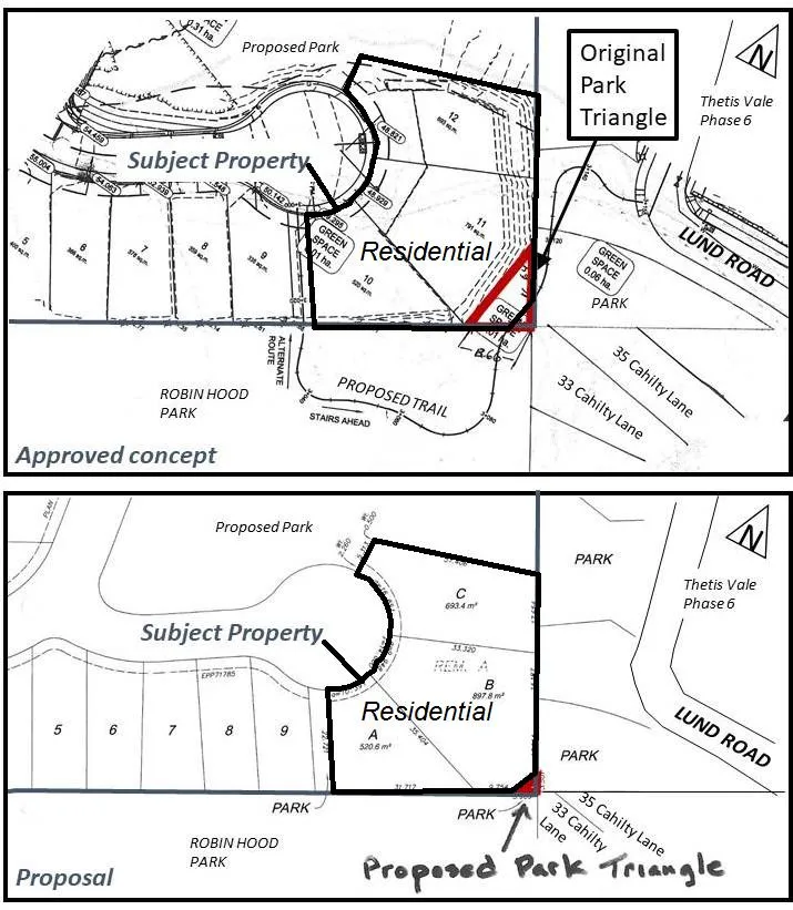
Figure 2. Original and proposed park triangle.
The change to the overall park dedication in Thetis Vale Phase 7 from 19,372m² to 19,266m² would be less than 1%. The next phase of the Chilco Trail would pass through the park triangle in an approximately 2.5m wide pinch point between 33 Cahilty Lane and the retaining wall as shown in Figure 3; however staff can confirm that the location is viable for the continuation of the trail. The applicant has provided a geotechnical report that indicates the downhill areas of the park are safe for the use intended in respect to the risk of geotechnical hazard from the retaining wall.
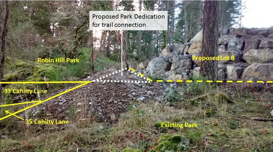
Figure 3. Looking west towards Proposed Park Triangle
As a community amenity contribution, the applicant has offered to provide approximately 133m of chain link fencing in the park to block off part of a cliff at the rear of several properties on Cahilty Lane (which were not developed by the applicant).
RECOMMENDATION:
THAT the report dated May 9, 2018 from the Senior Planner titled “Official Community Plan Bylaw No. 811, 2011 Amendment Bylaw No. 996, 2018 and Zoning Bylaw No. 900, 2014 Amendment Bylaw No. 997, 2018 - Lot A, Plan Tuzo Court” be received for information.
SUBMITTED BY:
Jeff Chow, MCIP, RPP
Senior Planner
REVIEWED BY:
Lindsay Chase, MCIP, RPP
Director of Development Services
Document Images
(3)