Council Report: 242-244 Island Hwy Rezoning R-1B to RM-3
Staff report recommending that Council receive information regarding a rezoning application for a 37-unit apartment building.
TOWN OF VIEW ROYAL COUNCIL REPORT
TO: Council
DATE: June 13, 2018
FROM: J. Davison, MCIP RPP, Planner
MEETING DATE: June 19, 2018
FILE NO.: 3360-20-2018-03
242-244 ISLAND HWY REZONING R-1B to RM-3
RECOMMENDATION
THAT Council receive the June 13 2018 report from the planner titled “242-244 ISLAND HWY REZONING R-1B to RM-3” for information.
CHIEF ADMINISTRATIVE OFFICER’S COMMENTS
I concur with the recommendation.
DIRECTOR OF DEVELOPMENT SERVICES’ COMMENTS
I concur with the recommendation.
DIRECTOR OF ENGINEERING’S COMMENTS
I concur with the recommendation.
PURPOSE OF REPORT
The purpose of this report is to introduce an application for a rezoning of two lots from R-1B: Detached Residential to RM-3: Mixed Residential, under a Mixed Residential (M-R) Land Use Designation within the Official Community Plan.
BACKGROUND
The site is currently zoned R-1B: Detached Residential and permits detached residential dwellings with suites. The Official Community Plan Land Use Designation prescribes up to 1.6 FSR and four storeys in an apartment configuration.
PROJECT INFORMATION
The proposal is for 21 one-bedroom units, and 16 two-bedroom units (for a total of 37 residential units) in a 13m high, four-storey configuration at 1.59 FSR. The permitted and proposed RM-3 zoning and parking requirements are listed below, noting that there are variances required for lot width and for front lot line setback. The proposal is consistent with the Mixed Residential (M-R) Land Use Designation within the OCP. The variances would be addressed at time of a Mixed Residential Development Permit for Form and Character, should a rezoning be successful.
Siting of Buildings and Structures (Zoning Bylaw No. 900, 2014 – Section 8.4.4)
| RM-3: Mixed Residential | Permitted | Proposed |
|---|---|---|
| Lot Size | ||
| Lot Size, minimum | 1500m² | 1842m² |
| Lot Width, minimum | 40m | 35.2m (variance) |
| Lot Density | ||
| Floor Space Ratio, Base Density | 1.5 | 1.49 |
| Floor Space Ratio with provision of 80% underground parking | Base Density + 0.1 | 0.1 |
| Lot Coverage, maximum | 60% | 47.20% |
| Impermeable Surface Coverage, maximum | 80% | 73.80% |
| Building Size | ||
| Building Height, maximum | 13.5m | 13m |
| Building Width, minimum | 6m | 27.4m |
| Accessory Building Height, maximum | 4.5m | n/a |
| Siting of Principal Buildings and Other Structures | ||
| Front Lot Line Setback, minimum | 7.5m | 4.3m (variance) |
| Rear Lot Line Setback, minimum | 7.0m | 7m |
| Side Lot Line Setback, minimum | 4.0m | 4.22m |
| Flanking Lot Line Setback, minimum | 4.0m | 4.2m |
| Siting of Accessory Buildings and Other Structures | ||
| All lot lines, minimum | 1.2m | n/a |
Parking (Zoning Bylaw No. 900, 2014 – Sections 5.10 and 5.11)
| RM-3: Mixed Residential | Required | Proposed |
|---|---|---|
| Vehicle Parking (total) | 45 | 45 |
| Vehicle Parking (surface) | n/a | 9 |
| Vehicle Parking (underground) | 20% (36) for 0.1 FSR | 36 |
| Class 1 Bicycle Parking | 1 per unit (45) | 45 |
| Class 2 Bicycle Parking | 6 space rack @ entrance | 6 space rack @ entrance |
Access and Road Standards
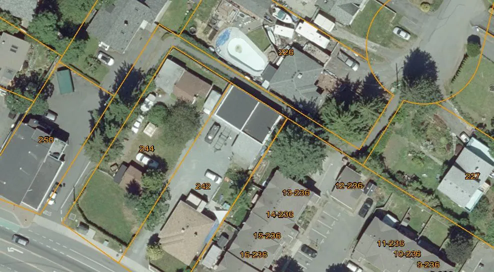
The proposal is to access the parking via the existing, unnamed town-owned roadway to the west of the property. The roadway is ~5.4m wide with no sidewalk and serves as an established pedestrian connection between Island Highway and Suzanne Place to the northwest.
Existing Pedestrian Connection
Existing Vehicular Access
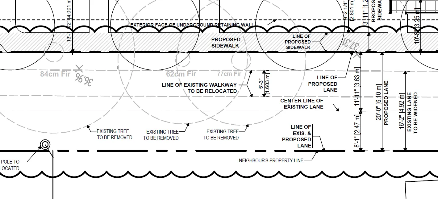
The existing 5.4m wide road right-of-way (with no grade-separated sidewalk) does not meet the Town’s minimum paved-surface access standard of 6m, and the increased traffic will require that there is a sidewalk provided for pedestrian traffic.
The access proposal places a 1.2m sidewalk on the subject property and creates a Town owned 6.1m paved travelling lane for vehicle and bicycle travel.
Under the proposal construction and maintenance of the sidewalk to Town standard would be the responsibility of the owner of the subject property. A covenant ensuring that a maintenance schedule reflecting Town standards must be in place, with mechanism to cover costs should the Town be required to step in and maintain. Public access over the sidewalk would be ensured through a statutory right-of-way placed over the sidewalk. Staff is currently working on both a covenant and a statutory right-of-way which would permit this configuration, and is expected to have that ready in advance of third reading of the bylaw.
At the Development Permit stage staff will be seeking a design for the intersection with Island Highway which would minimize vehicular congestion.
ISSUES AND ANALYSIS
Being a rezoning, the primary consideration is whether the site can support the use and density permitted in the RM-3 zone. The rezoning from R-1B to RM-3 is consistent with the use and density proposed in the Official Community Plan within the Mixed Residential land use designation. Staff also sees no concern regarding site access and servicing. There are no barriers to developing the site given the proposed changes to the access road right-of-way.
Staff is supportive the proposed access road profile as it will provide a good physical design on the site while only requiring that the applicant construct and maintain a concrete sidewalk. Staff is confident that a satisfactory covenant and statutory right-of-way can be arrived at which will satisfy all parties. The proposal will provide an acceptable sidewalk width and an acceptable paved traveling surface.
Property Considerations
A covenant registered on the lands coincident with third reading of the zoning amendment bylaw will require that the lots be consolidated into one lot and that the existing buildings be demolished at that time; until then the lands will not be permitted to be sold or otherwise transferred separately.
Community Amenity Contributions (CACs)
Where property is undergoing a rezoning, it is common for Council to consider whether or not a CAC might be appropriate. Other projects in the Town have provided a range of amenities, usually commensurate with the scale of the development and the change in use. Other projects in the immediate vicinity have contributed to projects identified in the View Royal Park Master Plan.
Historically, the amenity contributions for modestly sized projects such as these ranges from less than $1,000 to approximately $4,000 per unit.
In this case, the impact on the immediate neighbourhood (additional traffic, park space, pedestrian traffic, off-site parking etc) is expected to be modest. The improvements to the road right-of-way and the proposed sidewalk cannot be considered to be amenity contributions as they are addressing minimum standards required by the Town. They would be required as frontage improvements in conjunction with a Development Permit/Building Permit process.
The applicant has verbally agreed to a $750 per unit CAC, which staff considers to be reasonable given the modest nature of the development. A covenant will be used to secure the CAC.
CONCLUSION
The use and density of the proposal meets the Mixed Residential Land Use designation within the OCP and offers an increase in housing options and supply for the Town of View Royal. Staff is supportive of the proposal.
NEXT STEPS
After Public Hearing and before third reading of the bylaw, staff will prepare covenants to address the CAC and the maintenance of the sidewalk. Staff will also draft a statutory right-of-way addressing public access over the sidewalk.
Third reading of the bylaw is anticipated to take place on July 3, 2018 and adoption (if applicable) on July 17, 2018.
RECOMMENDATION
THAT Committee receive the May 1, 2018 report from the planner titled “242-244 ISLAND HWY REZONING R-1B to RM-3” for information.
SUBMITTED BY: J. Davison, MCIP RPP, Planner
REVIEWED BY: L. Chase, MCIP RPP, Director of Development Services
ATTACHMENTS:
- Subject Property Map
- Subject Property Orthophoto
- Applicant’s Statement – Alan Lowe Architect Inc. – February 20, 2018
- Site Survey – Bradley Cunnin – September 28, 2017
- Plans and Elevations – Alan Lowe Architect Inc. – May 15, 2018
- 242-244 Island Highway Circulation Comments Summary
Document Images
(4)