Appendix
Attachment 4. Proposed Foundation Position - Lot 3
April 2, 2013Page 541 section
Survey plan showing the proposed foundation position for the structure.
Date: February 13, 2012
PROPOSED FOUNDATION POSITION UPON LOT 3, BLOCK 12, SECTION 8, ESQUIMALT DISTRICT, PLAN 1688.
SCALE=1:250. All distances are in metres.
NOTE: Building positioned as per client instructions. Building position must be confirmed by approving authorities prior to construction.
Lot 3 is subject to Easement FB219569
This Plan lies within the Capital Regional District.
| Survey Information | Zoning & Set-backs |
|---|---|
| File: 36A-GB-LO | Zoning: R1 |
| Date: February 13, 2012 | Minimum Set-backs |
| Island Land Surveying Ltd. | Front: 7.5 |
| 1-115 Cadillac Avenue | Rear: 15.0 |
| Victoria, B.C. V8Z 1T3 | Interior side: 2.14 |
| Tel 250.475.1515 Fax 250.475.1516 | Total side: 6.10 |
| info@islandsurveying.ca |
LEGEND
- Denotes paint mark painted February 13, 2012
#.# Denotes ground elevation at paint mark
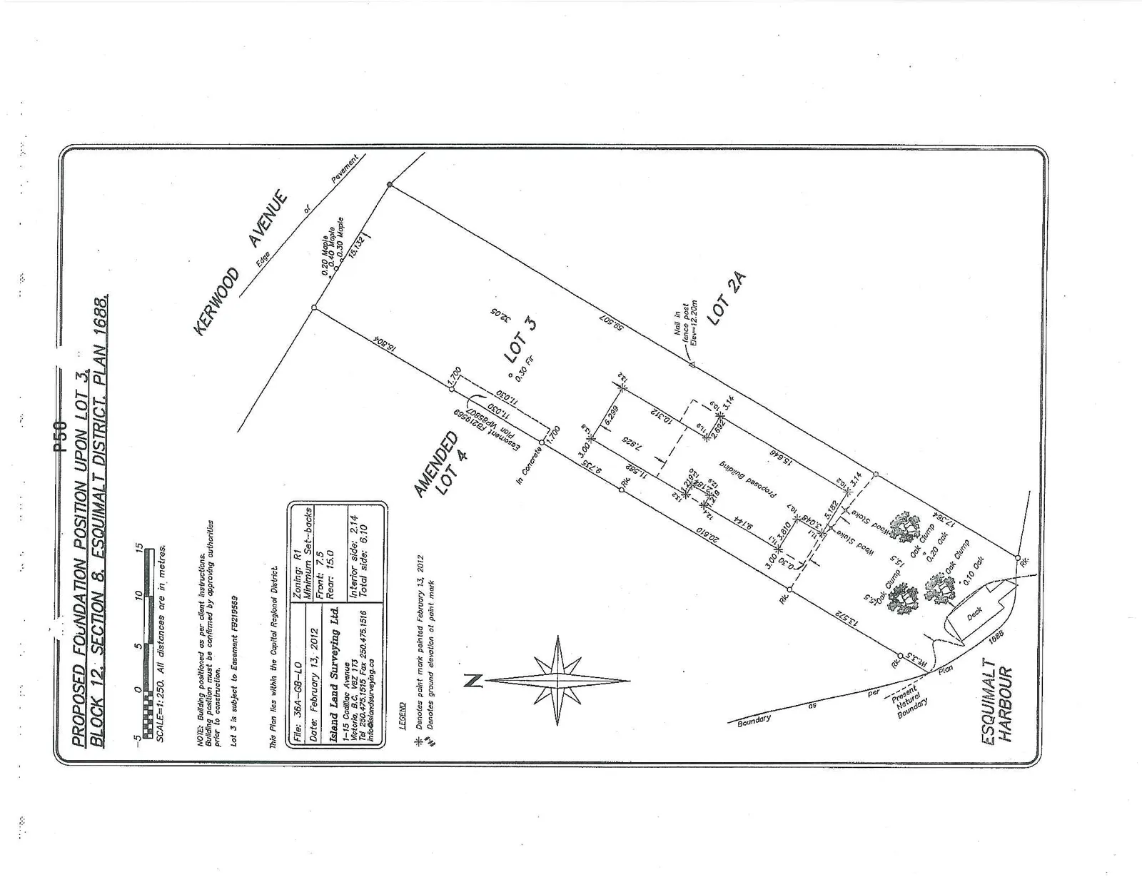
Site Plan Details
- Location: Lot 3, Block 12, Section 8, Esquimalt District, Plan 1688.
- Boundaries:
- North: Kerwood Avenue (Edge and Pavement)
- South: Esquimalt Harbour
- West: AMENDED LOT 4
- East: LOT 2A
- Easement: Easement FB219569 Plan VIP85807 located along the western boundary.
- Proposed Building: Footprint shown with various internal and setback dimensions.
- Survey Features:
- Nail in fence post (Elev=12.20m)
- Various Oak clumps and Maple trees noted with diameters (e.g., 0.20 Oak, 0.40 Maple).
- Wood stakes and rock (Rk.) indicators.
- Existing deck shown at the southern end near the harbour.
- North Arrow: Indicating orientation towards the harbour (South).
Page 54
Extracted from: 2013 04 02 Council Agenda