Appendix
Attachment 5. Site Plan, Plan & Cross Section - Java Designs
April 2, 2013Page 551 section
SITE PLAN, PLAN & CROSS SECTION
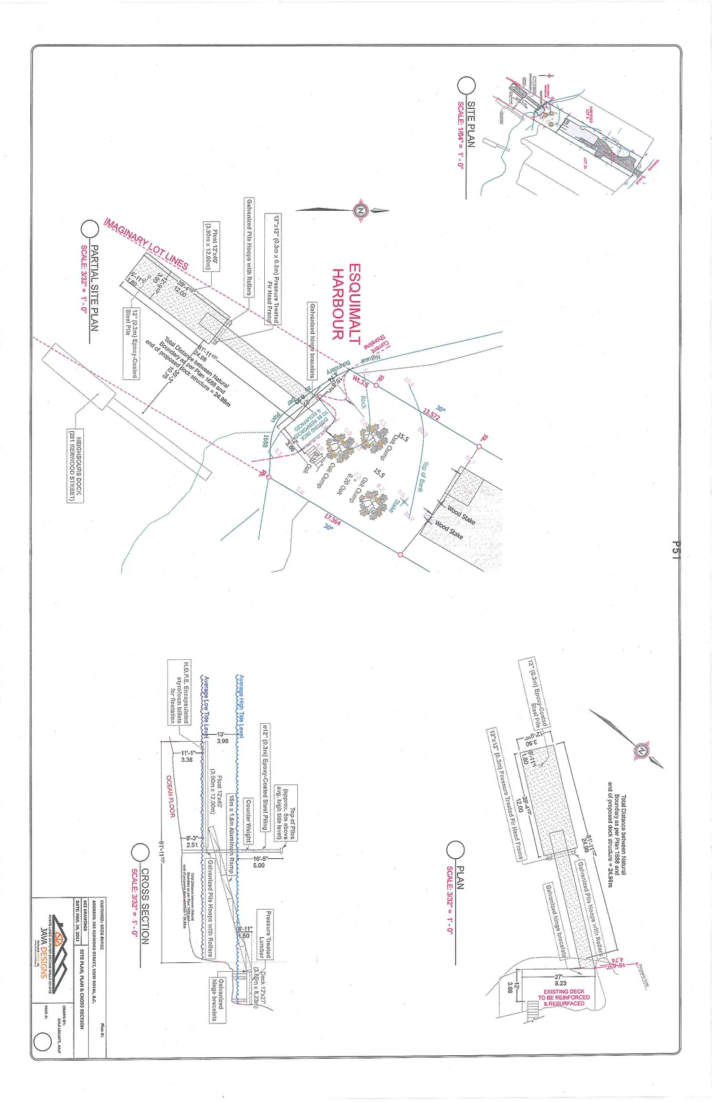
SITE PLAN
Scale: 1/64" = 1'-0"
PARTIAL SITE PLAN
Scale: 3/32" = 1'-0"
- ESQUIMALT HARBOUR
- Natural Boundary
- Current Shoreline
- Galvanized hinge bracelets
- 12"x12" (0.3m x 0.3m) Pressure Treated Fir Head Frame
- Galvanized Pile Hoops with Rollers
- Float 12'x40' (3.90m x 12.00m)
- IMAGINARY LOT LINES
- 12" (0.3m) Epoxy-Coated Steel Pile
- Total Distance between Natural Boundary as per Plan 1888 and end of proposed dock structure = 24.98m
- NEIGHBOURS DOCK (281 KERWOOD STREET)
- Plan 1888
- Top of Bank
- Wood Stake
- Oak Clump
- Rock
PLAN
Scale: 3/32" = 1'-0"
- Total Distance between Natural Boundary as per Plan 1888 and end of proposed dock structure = 24.98m
- 81'-11 1/2" / 24.98
- 12" (0.3m) Epoxy-Coated Steel Pile
- 5'-11 1/4" / 1.80
- 39'-4 1/2" / 12.00
- 12"x12" (0.3m) Pressure Treated Fir Head Frame
- Galvanized Pile Hoops with Rollers
- Galvanized hinge bracelets
- EXISTING DECK TO BE REINFORCED & RESURFACED
- 27' / 8.23
- 12' / 3.66
- Property Line
CROSS SECTION
Scale: 3/32" = 1'-0"
- Top of Piles (approx. 5m above avg. high tide level)
- ø12" (0.3m) Epoxy-Coated Steel Piling
- Average High Tide Level
- Average Low Tide Level
- H.D.P.E. Encapsulated styrofoam billets for floatation
- Counter Weight
- 15m x 1.6m Aluminum Ramp
- Float 12'x40' (3.90m x 12.00m)
- Galvanized Pile Hoops with Rollers
- Pressure Treated Lumber
- Deck 12'x27' (3.66m x 8.23m)
- Galvanized hinge bracelets
- OCEAN FLOOR
- Total Distance between Natural Boundary as per Plan 1888 and end of proposed dock structure = 24.98m
PROJECT INFORMATION
| Field | Details |
|---|---|
| CUSTOMER: | GREG BURKE |
| ADDRESS: | 283 KERWOOD STREET, VIEW ROYAL, B.C. |
| SEE DRAWINGS | SITE PLAN, PLAN & CROSS SECTION |
| DATE: | MAR. 26, 2013 |
| DRAWN BY: | KYLE LOGGETT, AS-cT |
| PAGE #: | PS1 |
| PLAN #: | Plan #1 |
Page 55
Extracted from: 2013 04 02 Council Agenda