ATTACHMENT 13 TOWN OF VIEW ROYAL COMMITTEE OF THE WHOLE REPORT
A detailed analysis and report for the Committee of the Whole regarding the Rezoning and OCP Amendment application for 339-345 Island Highway.
TOWN OF VIEW ROYAL COMMITTEE OF THE WHOLE REPORT
TO: Committee of the Whole DATE: May 24, 2023 FROM: Stirling Scory, RPP, MCIP Community Planner MEETING DATE: June 13, 2023
REZONING AND OFFICIAL COMMUNITY PLAN AMENDMENT 2023/01 – 339, 341, & 345 Island Highway
RECOMMENDATION:
THAT the report dated May 24, 2023, from the Community Planner titled “Rezoning and Official Community Plan Amendment 2023/01 – 339, 341, and 345 Island Highway” be received for information.
PURPOSE:
The purpose of this report is to present a Rezoning and Official Community Plan (OCP) Amendment application for the properties located at 339, 341, and 345 Island Highway. The proposal is to rezone the subject properties from the existing C-5: Tourist Commercial Zone to a new Comprehensive Development Zone and amend the OCP land use designation from Mixed-Residential to Neighbourhood Centre to construct a mixed-use development consisting of three buildings ranging in heights from six to eight storeys, with some ground floor commercial and approximately 259 rental apartment units.
TIME CRITICAL:
Currently, there are no concerns regarding timing from staff.
EXECUTIVE SUMMARY:
The purpose of this report is to provide the Committee with information, analysis and recommendation for a rezoning and official community plan amendment application for the properties located at 339, 341, and 345 Island Highway. The proposal is for a mixed-use development with a density of 1.74:1 floor space ratio (FSR) and approximately 259 apartment dwelling units and 1575 ft2 of commercial space. An amendment to the land use designation in the OCP from Mixed-Residential to Neighbourhood Centre is required to facilitate this development. The scope and intent of a rezoning and OCP amendment application are strictly to consider the use, density, height, and siting of buildings on the land. Form and character of the buildings and associated landscaping will be considered at time of development permit.
BACKGROUND:
The properties located at 339, 341, and 345 Island Highway comprise of a land area of approximately 12,129 m2. The site is presently occupied by ten buildings, which consist of a total of 36 rental dwelling units. The subject properties have been historically used as below-market rental housing in the community.
The site is located across the street from Fort Victoria, and adjacent to the Fire Hall and Public Safety Building. It also abuts Heddle Park, a small park that separates the development site and existing single-family homes to the south. Heddle Park is identified as a future trail connection.
The subject properties are located on the borders of the neighbourhoods identified in the OCP as the Harbour Neighbourhood (where this property is located) and the Helmcken Neighbourhood. The surrounding properties are zoned as follows:
Table 1 - Zoning and Land Use Review
| Address | Zone | Land Use Designation | Use |
|---|---|---|---|
| Subject Property | 339, 341, 345 Island Highway | C-5: Tourist Commercial | Mixed Residential |
| North | 340 Island Highway | C-6: Tourist Commercial (Campground) | Intensive Mixed Use (IMU) |
| West | 347 Island Highway and 585 Prince Robert Drive | CD-13: Comprehensive Development (Island Highway) R-2: Duplex Residential | Mixed Residential (M-R) |
| East | 333 Island Highway | P-8: Public Safety | Community Facility (CF) |
| South | 590, 560, 552, 550, and 542 Prince Robert Drive | R-1: Detached Residential (Large Lot) P-7: Utility Corridor | Large Lot Residential (R-L) |
PROJECT INFORMATION:
Zoning Review
The proposal is to rezone the subject properties from C-5: Tourist Commercial to a new comprehensive development zone. The following zoning data table compares the proposal with the existing C-5 Zone.
Table 2 - Zone Summary
| Existing (Permitted) (C-5: Tourist Commercial) | Proposed (New CD Zone) | |
|---|---|---|
| Floor Space Ratio | 0.4:1 | 1.74:1 |
| Lot Coverage (%) | 50 | 68 |
| Impermeable Coverage (%) | 80 | More information required. |
| Building Height (m) | 9 | 22.7 (8 storeys max. shown) |
| Front Yard Setback (m) – Prince Robert Drive) | 7.5 | 6 |
| Side Yard Setback (m) – (Heddle Park) | 6 | 8 |
| Rear Yard Setback (m) – (Fire Hall) | 7.5 | 6 |
| Flanking Yard Setback (m) – (Island Highway) | 3 | 6 |
The applicant has provided a conceptual design showcasing how the site may be developed given the proposed density, setbacks, and heights.
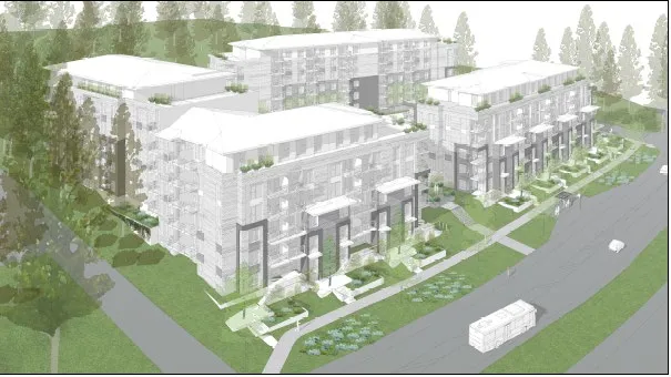
For the purposes of this report the buildings will be identified as building numbers 1, 2, and 3. For clarity, the site plan (Figure 1) references the assigned building numbers. Building one is six storeys, building two is eight storeys, and building three is seven storeys based on the definitions of the Zoning Bylaw.
The permitted number of storeys defined in the OCP is six; however, it is important to note that the number of storeys calculated is based on technicalities of the Zoning Bylaw and the additional storeys are the result of the site topography and the design of the underground parking. There may be opportunity to reduce the height of the buildings by locating the parking further underground to avoid having some of the parking structure above grade; however, a redesign to locate parking further underground would be at significant cost to the applicant, and may alter the proposal (i.e. number of dwellings, site design, more impact to trees). As proposed, the applicant would be required to vary the height of the building. Building two would appear to be eight storeys because of topography and the building’s stepped design along single building face that extends from Island Highway to the rear of the property.
The proposed parking for residential units meets the zoning bylaw requirements; however, the parking calculations do not account for accessible parking requirements. The applicant would require a variance of two spaces for the total required commercial parking for the site. Further details on parking stall dimensions have to be confirmed to understand if additional variances are required. A loading space has been provided for the commercial space but is not required. A parking summary is provided in Table 2 below.
Table 3 - Parking Summary
| Parking by Type | Units | Parking Requirement | Parking Proposed |
|---|---|---|---|
| Studio | 7 | 1 per dwelling unit | 7 |
| 1 Bedroom | 117 | 1 per dwelling unit | 117 |
| 2 Bedroom | 130 | 1.5 per dwelling unit | 195 |
| 3 Bedroom | 5 | 2 per dwelling unit | 10 |
| Total Small Car Parking (%30) | 35 (spaces proposed) | 99 (max permitted) | 35 |
| Electric Vehicle Parking | 1 | 0 (variance) | |
| Accessible Parking | 3 | 0 (variance) | |
| Commercial Parking | 146 m2 (1575 sq ft) | 1 per 15 m2 (café) | 8 (variance) |
| Commercial Loading Zone | Not required | 1 | |
| Bicycle Parking | 259 | 1 per dwelling unit | 1 per dwelling unit (259 total spaces) |
Note: the required parking for a commercial use is dependent upon the use.
Figure 1 - Site Plan
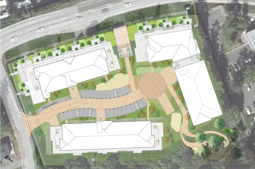
Figure 2 - Cross Section Building 1 and 3 (Prince Robert Drive)
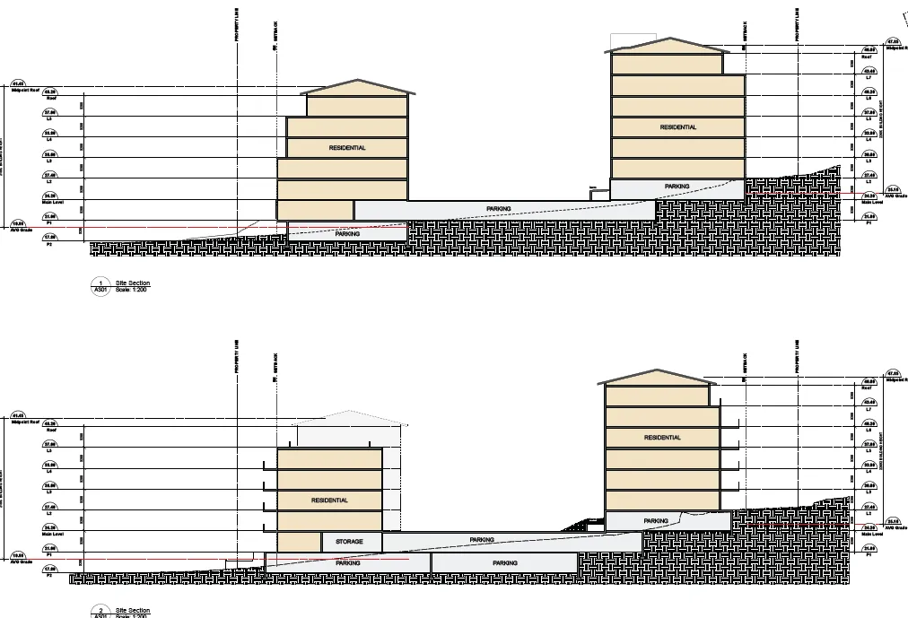
Figure 3 - Cross Section Building 1 and 2 (Prince Robert Drive)
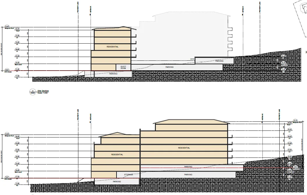
Figure 4 - Conceptual Rendering (Prince Robert Drive)
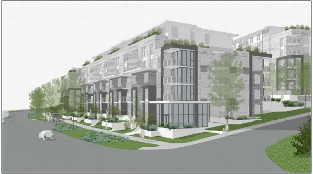
Figure 5 - Conceptual Rendering (Island Highway)
Unit Mix
The proposal is currently for 259 rental apartments, 1 commercial retail unit (CRU), and amenity flex space, configured as follows:
Table 4 Unit Mix Data Table (Conceptual Only)
| Type | Number Of Units | % of Total | Size |
|---|---|---|---|
| Studio | 7 | 3% | 450 – 575 sf |
| 1 Bedroom | 117 | 45% | 600 – 710 sf |
| 2 Bedroom | 130 | 50% | 845 – 905 sf |
| 3 Bedroom | 5 | 2% | 1,105 sf |
| CRU | 1 | N/A | 1,575 sf |
| Amenity Space | 2 | N/A | 1,435 sf (940 + 495) |
Note that number and size of units is subject to change until building permit approval.
The applicant is proposing 135 larger size dwelling units (two- and three-bedroom units), which would be suitable for households with children. Staff recommend securing the larger size units in a legal agreement, which further advances housing objectives in the current 2011 OCP.
DISCUSSION:
In consideration of the proposal, there are key considerations that must be reviewed to understand how the proposed project aligns with municipal policy, zoning regulations, and the guidelines of the official community plan. A review of these key considerations is summarized below.
1. Official Community Plan (Policy Review)
The subject properties OCP land use designation is “Mixed Residential”, which supports the following land uses, heights, and densities:
- Small lot detached houses, townhouses, and low-rise apartments up to 3 storeys and a maximum 1.25:1 floor space ratio; or
- Four storeys for apartment dwellings and a maximum floor space ratio of 1.5:1
The existing land use designation does not support the proposed use, height or density; therefore, the applicant is required to make an application to request an amendment to the OCP from Mixed Residential to the Neighbourhood Centre land use designation, which support the following land uses, heights and density:
- Commercial with apartments up to a maximum of 6 storeys and a maximum floor space ratio of 3.0:1 permitted
The proposal is consistent with the Neighbourhood Centre designation, as it proposes apartments with commercial space and has a maximum floor space ratio of 1.74:1. However, the proposal exceeds the permitted six storeys supported in the land use designation because of the above grade parkade projections, which are technically considered a storey in the zoning bylaw. The additional height to accommodate the parkade projections would be treated as variances. Alternatively, the applicant may be able to redesign their buildings and parking configuration to remove above grade parking foundation; however, this would have to be further explored with the applicant.
The proposal is further advancing several 2011 OCP policies, which are listed below:
- Policy LU1.1 Neighbourhood Centres
- Create a network of neighbourhood-serving, mixed-use centres and encourage new and infill residential and commercial growth
- Policy LU1.4 Diversity of Forms and Uses
- Support a variety of residential and commercial forms and uses to encourage socio-economic diversity
- Policy LU4.5 Street-oriented Buildings
- Encourage street-oriented building
- Policy HS1.1 Range of Housing Types
- Support a range of housing including apartments that meet needs of current and future residents
- Policy HS1.6 Loss of Rental Housing
- Where a proposal sees loss of low income households, have applicant provide statement outlining provisions regarding notice and relocation assistance to tenants
The proposed density requires that the applicant amend the land use designation and in doing so triggers a requirement that commercial space be provided. The new comprehensive zone will require that a minimum of 140 m2 (1500 ft2) in building one to ensure that a neighbourhood servicing business will be provided. The ground floor commercial space can be secured through a legal agreement (covenant).
The proposed development design is conceptual only; the design details for this building and site will be determined at the time of development permit.
2. Potential Land Use Impacts
a. Transportation and Parking – Draft Traffic Impact Assessment (TIA)
The applicant engaged WATT Consulting Group to prepare a Draft Traffic Impact Assessment for their application (refer to Attachment 6). The key highlights of the report can be summarized as follows:
- Install a 20m westbound left turn lane on Island Highway at Prince Robert Drive.
- Upgrade the cross section of Prince Robert Drive with a paved shoulder along the development frontage.
- Install a sidewalk with landscaped boulevards along the development frontage of Island Highway.
- Upgrade the existing bus stops as per BC Transit and View Royal direction.
- Consider signalization (or other traffic control) of the Island Highway / Prince Robert Drive intersection in the long term: signalization would be required if the side street volumes reach a signal warrant level.
The Town retained a third-party review regarding the Island Highway / Prince Robert Drive intersection. This was completed by Bunt & Associates, due to the Town’s concerns that the additional traffic loading exceeds the Town’s Transportation Master Plan, which is based on the site’s OCP land use designation. The third-party review stated the following: i. A traffic-controlled intersection should be considered for the Prince Robert Drive and Island Highway intersection in coordination with the development. ii. A left turn lane from Island Highway to Prince Robert Drive may mitigate issues; however, it does not mitigate problematic delays for vehicles turning from Prince Robert Drive to Island Highway.
Staff recommends that the requirement for a traffic-controlled intersection be secured in a legal agreement as a condition of rezoning. A revised Traffic Impact assessment will also be required to be submitted to the Town and to the satisfaction of the Director of Engineering prior to public hearing.
b. Density, Setbacks, and Height
The proposal requires a new Comprehensive Development Zone to be created. The siting of the buildings results in a reduction to the existing permitted setbacks in the C-5 Zone, but significantly improves the street activation and appearance by providing ground-oriented units on Island Highway. Greater emphasis could be placed on making a more pedestrian oriented design for the portion of the buildings that face Prince Robert Drive.
The proposed setbacks for the front, side, and rear yards are less than what is required in the existing zone. Given the proposed height of the buildings, a larger setback may be justified, alternatively, greater articulation of the building may be warranted to provide more of a spatial setback between the existing residential neighbourhood and the proposed development, and reduce the perceived building mass. The form and character of the buildings would be further evaluated against the applicable design guidelines at the time of development permit.
c. Servicing Requirements & Impacts
The applicant has provided a conceptual servicing report (refer to Attachment 5) and conceptual frontage drawing (refer to Attachment 4) for the proposal, which is acceptable for rezoning. Final details will be confirmed at the time of Building Permit at which point staff and the applicant will complete a servicing agreement.
Staff are awaiting comments from some external agencies, including the CRD and Fortis BC. Comments from BC Hydro have been received and shared with the applicant. Requirements specified by these agencies will be the responsibility of the applicant, and coordination with the Town will be ongoing.
The frontage drawing is inconsistent with the proposed access in the drawings and will need to be updated. This can be completed prior to public hearing. It should be noted that the boulevard along the Island Highway frontage is fairly wide and could be a suitable location to plant additional trees, sight lines permitting.
d. Environmental Impacts
The subject properties are not located within the Sensitive Terrestrial Ecosystem Development Permit Area. No further study will be considered for the site. The applicant has submitted the Town’s Sustainability Checklist, attached to this report (Attachment 10)
e. Fire Service
There are no special concerns considered by the Town’s Protective Services Department. At time of Building Permit the applicant will be required to provide more detailed design information.
f. Tree Impacts & Landscaping
Arborist Report
The applicant has provided an arborist report (refer to Attachment 7), prepared by Talmack Urban Forestry, which details the methods of removal, and the trees proposed for removal. A total of 138 protected on-site trees are proposed for removal to facilitate the construction of the proposed apartment buildings and underground parking structures. Those 138 trees would be required to be replaced at a 2:1 ratio as per the Tree Protection Bylaw, which would result in a total of 276 replacement trees, or a cash-in-lieu contribution to the Town for the number of replacement trees not planted on site, or a combination of the two options.
Staff have expressed a desire to retain additional trees along the rear property line (Fire Hall) that have been identified for removal. The applicant has been receptive of staff’s comments to adjust building setbacks to property line, to retain additional trees and provide a vegetative landscape buffer between the subject property and neighbouring properties. The 6 m setback to rear property line does provide ample space for replanting; however, the development would require that all existing trees be removed.
Of additional concern are the trees that are located beyond the building envelope (and beyond the detailed protective fencing) that are also marked for removal. The arborist report states that there are 19 municipal trees and a hedge that are to be retained during construction; however, the plans show that some of the trees are marked for removal. Staff recommend that the applicant explore opportunities to retain additional trees and update the arborist report, accordingly, prior to consideration by Council. Council may consider requesting the applicant’s arborist to provide additional details on how to retain these trees to maintain good health, including but not limited to temporary irrigation of trees during the dry season when the land is altered, and additional measures required for sensitive trees near foundation excavation areas.
There are 32 on-site trees located at the southeast corner of the site that are proposed for retention and would be incorporated into an on-site green space. The arborist notes that retention is possible, whereby the English Ivy is removed from the trunk and canopies of the retained trees. A detailed design of the woodland trail will be required before Talmack Urban Forestry is able to provide a detailed impact assessment and detailed mitigation recommendations for trail construction.
There are inconsistencies in the report on where trees are in relation to the property boundaries. Of concern are those trees shown in the Town’s property (Heddle Park) that are considered to be ‘on-site’, and vice-versa. Further clarification is required on this matter. Should the application move forward, staff would ask the applicant to revise the arborist report prior to public hearing. Prior to removal of any trees, the applicant would be required to have an approved building permit and an approved Tree Permit.
Finally, it should be noted that the arborist report did not inventory trees located on neighbouring properties, within influencing distance of the subject site. Per the Tree Protection Bylaw, any works that may affect trees on neighbouring properties requires the neighbouring property owner’s express permission prior to such works - this is generally a condition of the Town’s Tree Permitting process. Staff recommend that the arborist assess these neighbouring trees in the revised arborist report to determine if any such influence may occur from construction, and to ensure that such permissions are confirmed for future tree permitting.
Landscape Plan
At this time a detailed landscape plan has not been prepared; however, it would be a requirement of a development permit application should the rezoning and OCP amendment be approved. Staff have concerns with the potential constraints to provide the required number of replacement trees on-site given the proposed conceptual design. There are limited landscaping areas, and the site design does not provide much opportunity for substantial tree replacement and for these reasons, staff recommends that the applicant consider refinements to the siting of buildings and additional tree retention, where feasible, on site.
The applicant will be required to install a fence along the south property line adjacent to Heddle Park.
g. On-site Invasive Species Removal and Natural Buffer
The site contains invasive species that are impacting the native vegetation. To ensure the removal of English Ivy and other invasive species on site, staff recommends that a legal agreement be registered on title as a condition of rezoning. This work may be secured by a landscape security deposit to be provided by the applicant at time of building permit and would also be a condition secured in the legal agreement.
Furthermore, staff would also recommend that a no build and no disturbance covenant be registered on title to protect the lands south of the proposed building. The covenant area would serve as a natural buffer to Heddle Park and an additional vegetative buffer to the existing residential neighbourhood that abuts the development site.
3. Community Amenity Contribution Policy and Housing
Community Amenity Contribution Policy
In accordance with the Community Amenity Contributions Policy, the applicant agreed to complete a Land Lift Analysis. The Land Lift Analysis, was completed by Mulholland & Parker Land Economists Ltd (refer to Attachment 12). The purpose of the analysis is to estimate the land lift (value) and amenity contribution on the site due to a change in the permitted use and density from the existing zone and land use designation. Where a lift in land value is determined to be the case, the Town would take 50% of the lift value, and the cost to complete the study would be deducted from the community amenity contribution amount. However, where there is no or negative land lift, the Policy states that alternative amenities may be negotiated.
The land lift analysis concluded that there is currently no residual land value supported by the proposed development of 259 rental apartments and 1,575 square feet of commercial space on the site; and therefore, there is no land lift from the proposed rezoning. However, the Policy stipulates that $4000 per unit or other tangible amenities be provided for multi-unit residential development. Staff recommends to Council that staff and the applicant have further discussion on potential opportunities for amenity contributions as per the Policy.
Housing
The 2011 OCP acknowledges the major issues concerning the lack of affordable housing in the community, and in the greater Victoria Region, and the rising land and construction costs. The 2011 OCP strongly encourages the inclusion of affordable housing units in larger multi-unit residential developments. In consideration of the application, staff recommend that the applicant consider providing secure below-market rental housing in this development proposal, to be secured through a legal agreement either in perpetuity or for a determined time period (e.g. 25 years). Given the site’s proximity to transit stops, the E&N Rail Trail, and within 400m of the small urban village at Helmcken and Island Highway, the location of the development in the region provides ample opportunity for persons of a lower income to benefit from below-market rental housing in this location. This would be considered a community amenity.
4. Tenant Assistance Plan
Staff advised the applicant that a tenant assistance and relocation plan be provided. A plan has been provided, but further details will be required prior to public hearing. The tenant assistance and relocation plan would provide compensation to tenants to assist with their rent and moving expenses (Attachment 8).
The applicant is in the process of working with a tenant relocation coordinator to aid tenants with future relocation. Further information will be provided to Council once details are confirmed with the applicant.
5. Public Consultation
The applicant completed a neighbourhood information session on Wednesday April 27th, 2022, from 7:00 pm to 8:00 pm at Strawberry Vale Community Hall. The purpose of the meeting was to introduce and share the development concept to neighbours, seek early feedback, and provide answers to questions regarding the project.
Eight members of the community attended the neighbourhood information session. Comment forms were available for feedback; two forms were completed. A summary of the comments is available in Attachment 9.
At time of writing this report staff have received two emails from members of the public regarding the proposal, attached to this report as Attachment 11.
SUSTAINABILITY/CLIMATE CHANGE IMPACTS:
The proposal would have to comply with BCBC and BC Step Code requirements at time of building permit application. The current step code requirement is Step 2. The applicant would be required to construct the building to the standard required at the time of application. Should the step requirements increase prior to building application submission the new requirements would have to be met.
The subject properties are also located on a transit route and near the E&N Rail Trail, encouraging other modes of transportation.
The applicant has completed the Town’s Sustainability Checklist and is attached to this report (Attachment 11) for review.
FINANCIAL IMPLICATIONS:
The Town would be responsible for maintaining a new signalized intersection, and sidewalks, boulevard and trees once installed by the applicant.
ALTERNATIVES:
There are no alternative recommendations for this application.
CONCLUSION:
The proposal to construct a mixed-use development further advances several housing and complete community objectives in the 2011 OCP. Should the Committee advance the application to Council, staff will continue to work with the applicant on the items identified in this report in preparation of bringing this application to Council for formal consideration ahead of introductory readings of the bylaws. Any feedback that is provided as part of the Committee meeting will be reviewed and incorporated as required. Staff recommend that the application be received for information and that the application be brought forward to Council for formal consideration.
| CONCURRENCE: | Initials | Comments |
|---|---|---|
| Chief Administrative Officer | KA | Recommend approval. |
| REVIEWED BY: | Initials |
|---|---|
| Director of Corporate Administration | N/A |
| Director of Finance | N/A |
| Director of Development Services | LT |
| Director of Engineering and Parks | IL |
| Director of Protective Services | N/A |
ATTACHMENTS:
- Letter to Mayor and Council
- Survey Plan
- Conceptual Design Plans
- Conceptual Frontage Drawing
- Conceptual Servicing Report
- Traffic Impact Assessment
- Arborist Report
- Tenant Assistance and Relocation Plan
- Neighbourhood Feedback Summary
- Sustainability Checklist
- Public Correspondence
- Land Lift Analysis
Document Images
(1)