STAFF REPORT: REZONING – 3, 5 and 9 Helmcken Road and 1449 Burnside Road West (Eagles Nest)
A staff report from the Community Planner providing analysis and recommendations for the proposed 247-unit 'Eagles Nest' apartment development.
TOWN OF VIEW ROYAL
PUBLIC HEARING REPORT
TO: Council
DATE: June 10, 2020
FROM: J. Davison, MCIP Community Planner
MEETING DATE: June 16, 2020
FILE NO.: 3360-20-2020-01
REZONING – 3, 5 and 9 Helmcken Road and 1449 Burnside Road West (Eagles Nest)
RECOMMENDATION
THAT the report from the Community Planner dated June 10, 2020 titled “Rezoning – 3, 5 and 9 Helmcken Road and 1449 Burnside Road West (Eagles Nest)” be received for information.
CHIEF ADMINISTRATIVE OFFICER’S COMMENTS
I concur with the recommendation.
DIRECTOR OF ENGINEERING’S COMMENTS
I concur with the recommendation.
DIRECTOR OF PROTECTIVE SERVICES’ COMMENTS
I concur with the recommendation.
PURPOSE OF REPORT
The purpose of this report is to support the Public Hearing for Bylaw No. 900, 2014 Amendment Bylaw No. 1050, 2020 to rezone the Burnside Helmcken properties at 3, 5 and 9 Helmcken Road and 1449 Burnside Road West (henceforward known as the ‘Eagles Nest’ property) to an attached 3-building apartment configuration with a proposed 247 units.
BACKGROUND
This application follows an earlier application made in 2018. Committee of the Whole recommended against moving that application to bylaw readings despite several iterations of the design during 2018-2019.
PROJECT INFORMATION
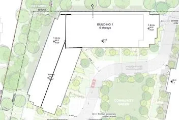
NOTE: CORRECTION TO INFORMATION PROVIDED (Friday June 12, 2020).
Please note that it has come to Staff’s attention that the information presented in the submitted drawings and staff report is different to that provided in Zoning Bylaw No. 900, Amendment Bylaw No. 1050 regarding Building 1 storeys.
The information in the bylaw is the correct information and will stand.
The applicant has provided updated architectural drawing files which are listed in the correspondence section of the Town’s Public Hearing web page. The applicant has also updated their presentation to reflect this.
Incorrect Staff Report version (with the storeys in red numbers)
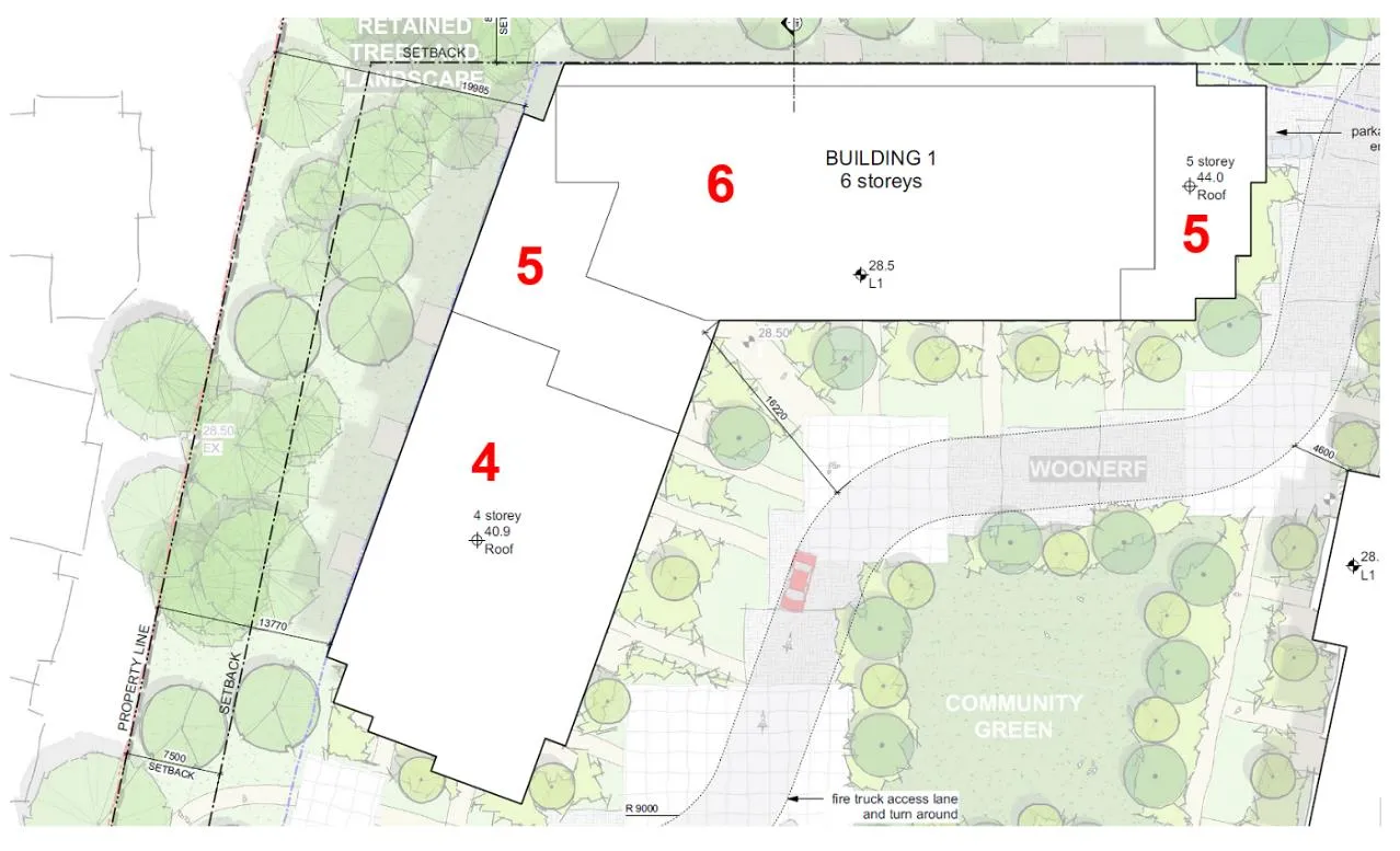
Correct Bylaw version (with the storeys in red numbers):
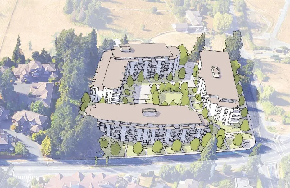
The application re-configures the site in response to Council’s concerns regarding the previous design’s density, height, siting, and site circulation. In general terms the revised proposal is supportable by staff. The determining factor for this project will be Council’s appetite for the revised design and slightly reduced FSR in the context of this property within the Town’s Official Community Plan’s Northern Gateway Community Corridor that is also identified as one of the Change Areas within the bylaw.
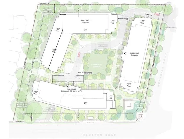
The previous four-building proposal has been re-configured into three separate structures in a more contextually appropriate design.
Site Data Summary
| Current Proposal | Previous Proposal | |
|---|---|---|
| Density | 1.50 FSR | 1.57 FSR |
| Site Coverage | 34% | 33% |
| Units Proposed | 247 | 262 |
| Vehicle Parking | 340 | 356 |
| Bicycle Parking | 246 Class 1 and 18 Class 2 | 262 Class 1 and 6 Class 2 |
The parking as proposed meets the bylaw requirements; no variances are required.
Unit Mix
The proposal is currently for strata condos in the following configuration:
- 85 one-bedroom units
- 140 two-bedroom units
- 22 three-bedroom units
The unit mix can change as the project moves through the Development Permit process if parking requirements are met and FSR is not exceeded.
Building Height
The proposal ranges from three storeys at the lowest points of the buildings, stepping up to a portion of Building 1 at six storeys on the north side adjacent to the ALR land. The buildings have been stepped and pulled back from strategic points to minimize neighbouring visual impact. Building 1 is 19.2m high and ranging from 4 to 6 storeys, strategically stepped to address the Hidden Oaks views.
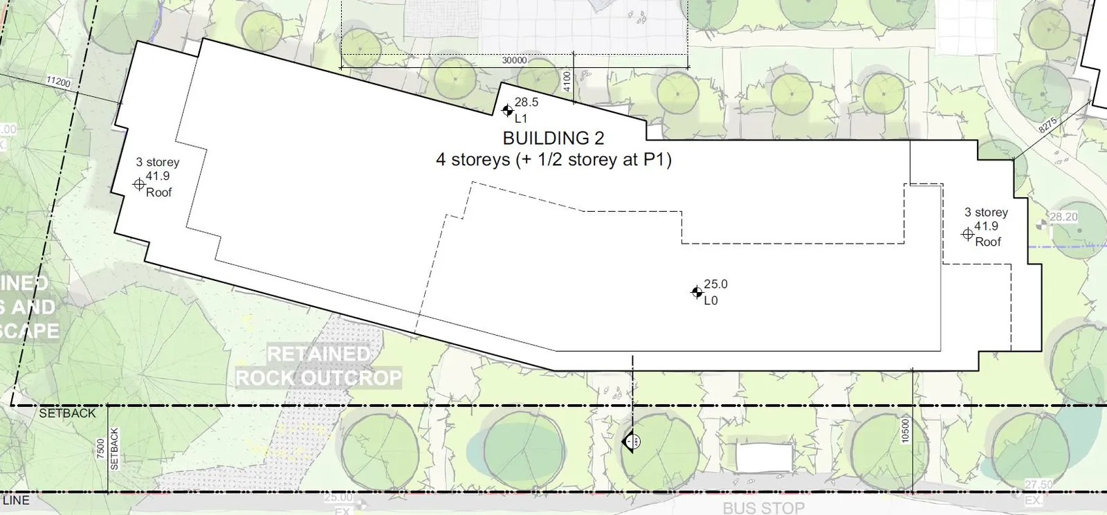
Building 2 is 14.8m high and ranging from 3 to 4 storeys (plus ½ storey at P1), again stepped from 3 to 4 storeys to address the Hidden Oaks interface.
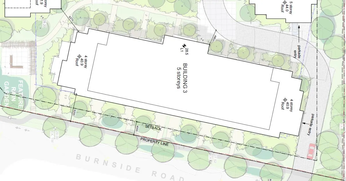
Building 3 is 16.9m high and ranging from 4 to 5 storeys.
In support of the application the following has been submitted:
- Rezoning Application Submission Summary Document – Applicant – January 17, 2020
- Architectural Drawings – de Hoog & Kierulf architects – January 22, 2020
- Civil Engineering Drawings – McElhanney Consulting Services Ltd. – January 23, 2020
- Landscape Drawings – Murdoch DeGreeff – January 22, 2020
- Survey Plan – McElhanney Consulting Services Ltd. – February 23, 2018
- Letter to Mayor and Council – January 19, 2020
- Community Engagement Summary – March 4, 2020
- Stormwater Management Plan – September 13, 2018
- Traffic Impact Assessment – WATT Consulting Group – January 10, 2019
- Tree Preservation Plan – September 14, 2018
- Phase 1 ESA Report - McElhanney Consulting Services Ltd. – March 8, 2018
- Parking Study - Watt Consulting Group – September 14, 2018
- Helmcken Road Report – Watt Consulting Group - March 27, 2019
- Geotechnical Memo – Ryzuk Geotechnical – March 9, 2018
- Limited Hazardous Materials Investigation – Island Environmental Health & Safety Ltd. - March 20, 2018
- Helmcken & Burnside Tenant Relocation Matrix – Applicant - January 22, 2020
- Eagle’s Nest Development Data – Applicant - February 4, 2020
- Relative Height Illustration with Eagle Creek – Applicant – Undated
Official Community Plan Context
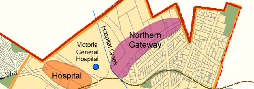
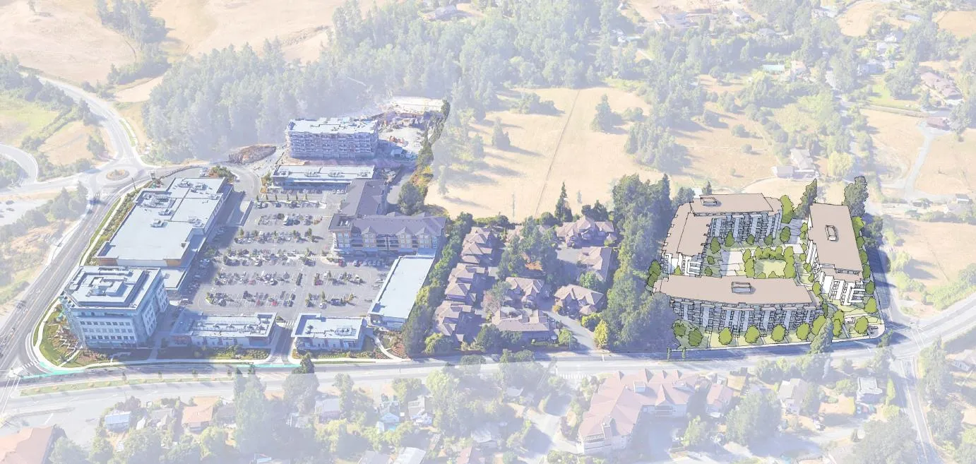
The subject property (on the map below in blue) is an important gateway site for the Town of View Royal. The design of the Northern Gateway Community Corridor requires the creation of “…a strong sense of place in the area surrounding the hospital and leading into the southern areas of the Town”.
The Northern Gateway Community Corridor includes the lots fronting Helmcken Road between Burnside Road and the Trans-Canada Highway, and a few lots on Watkiss Way on the east side of the Helmcken intersection. The corridor has experienced incremental infill development in the form of higher density housing. A continuation of residential infill that will bring more housing closer to the hospital and revitalize underutilized land is envisioned for the Northern Gateway Community Corridor. Ancillary commercial and hospital-related uses will also be encouraged as part of mixed-use projects closer to the Trans-Canada Highway and the larger parcels near Watkiss Way.
Development in the Northern Gateway Community Corridor should be carefully reviewed to consider the following:
- Uses and densities that benefit from the Corridor’s proximity to the Victoria General Hospital and the planned regional rapid transit stop. Attached housing, including townhomes and apartments, should be encouraged throughout the Corridor.
- Access and circulation.
- Quality of the built environment.
- Wayfinding and placemaking elements that reinforce the Hospital Neighbourhood as the northern gateway to View Royal and create a strong sense of place in the area surrounding the hospital and leading into the southern areas of the Town.
- Connections to the planned hospital rapid transit stop, Galloping Goose Regional Trail, Trans-Canada Highway and established residential area east of Helmcken Road.
This is the current proposal for the Burnside/Helmcken intersection interface. It provides an attractive entry feature that is much improved over the existing condition with fully realized building facades that address the street corner in an attractive fashion.
While detailed design is addressed at the Form and Character Development Permit stage, the application provides a level of detail that establishes those expectations along with the rezoning. Council will have full control over the form and character of the project when considering the Development Permit at a later date.
Design
With the new proposal, the applicant has reduced the number of buildings from four to three, stepped the top floors back from the building facades, and pulled the buildings back from the Hidden Oaks boundary. There is much more visual interest in the building articulations from all external angles. The western interface between the Hidden Oaks development, especially, has been reconfigured in a positive manner.
- There is a focus on reducing visual and physical impact on the Hidden Oaks townhouses to the west. The terracing of the building, partial storeys and the open space between the two buildings provides more relief than the previous uniform building wall. The buildings are also pulled back from the shared property line, providing varied, treed open space for screening between the two developments.
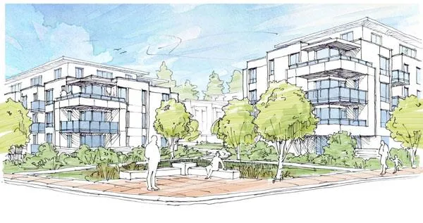
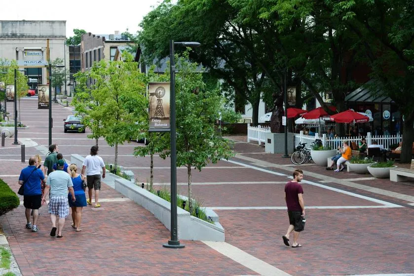
- The new proposal provides a more multi-use feel in the courtyard with a proposed ‘woonerf’ (literally: ‘living street’ in Dutch) which emphasizes shared space and traffic calming while still permitting traffic flow. Protective Services requires that the woonerf meet BC Building Code (BCBC) for Fire Truck Access. While the applicant has assured staff that it meets minimum BCBC requirements, additional consideration will need to be made regarding design details to accommodate the Town’s ladder truck and an acceptable turnaround or loop design.
A large element of the concept is to design a functional roadway with non-traditional road surfaces that resemble pedestrian-friendly squares and plazas. This invites pedestrian and bicycle traffic and indicates to drivers that it is a shared space and not a dedicated roadway. This project’s space is in a conceptual stage which may be refined at the Form and Character Development Permit stage.
Woonerf examples are below:

Community Amenity Contribution
The applicant has agreed to the community amenity contribution (CAC) target set out by the Town’s CAC policy’s standard rate of $3,500 per additional detached residential unit to be provided prior to building permit issuance. For this proposal, the contribution would be $864,500 based on the per-unit rate. Note that the number of units can change in the future.
The applicant has offered to pay the $3,500 per unit fee. The community amenity contribution rate and provision will be secured in a covenant.
OCP Policy HS1.4 Housing Amenity Contributions supports a housing amenity contribution to the Town, which could be directed to the CRD Regional Housing Trust Fund. A portion of the cash community amenity contributions could be used for this purpose.
Transportation Impact
The Town’s Engineering Department (with assistance from Bunt & Associates Transportation Planning & Engineering’s peer review) has completed the following initial review of the provided transportation impact assessment (TIA):
- It appears that waiting to see how McKenzie Interchange impacts traffic flow would be prudent. We note the Town is doing the same for several other traffic issues.
- Both the southbound traffic on Helmcken and the westbound and perhaps eastbound traffic on Burnside may require alteration of the intersection. (the applicant had suggested originally that they would vastly improve traffic flow with their suggested improvements)
- The TIA suggests that they do not have an impact on traffic volumes (section 4.8) and all issues are a result of the background (existing) traffic:
- “It is important to highlight that future failing conditions are due to background traffic, not site generated traffic. When site traffic is added to the study area intersections at buildout and 10 years beyond buildout, site traffic has minimal impact on level of service, delay and queuing at both intersections.”
- Alternatively, they speak to the impacts of even small amounts of traffic (section 4.7):
- “As noted, small volume increases to an already failing movement can exponentially increase delay and/or queuing”.
- Bunt points out that additional right-of-way may be required on the Burnside frontage which suggests alteration of the eastbound leg of Burnside and a sidewalk on the frontage.
- Once the McKenzie Interchange is complete an agreed upon assessment should be completed to determine mitigation expectations of the Town of View Royal.
Site Servicing
The applicant is working on a detailed conceptual site servicing plan which would indicate water and wastewater capacities, as well as shallow servicing plans. Staff does not anticipate issues in this regard.
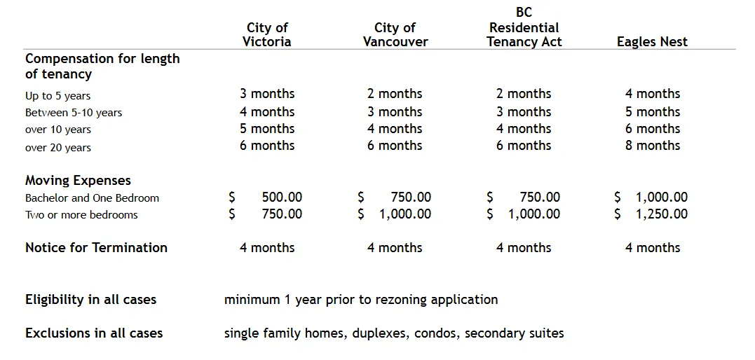
Tenant Compensation
The applicant has provided a Tenant Relocation Plan:
| City of Victoria | City of Vancouver | BC Residential Tenancy Act | Eagles Nest | |
|---|---|---|---|---|
| Compensation for length of tenancy | ||||
| Up to 5 years | 3 months | 2 months | 2 months | 4 months |
| Between 5-10 years | 4 months | 3 months | 3 months | 5 months |
| over 10 years | 5 months | 4 months | 4 months | 6 months |
| over 20 years | 6 months | 6 months | 6 months | 8 months |
| Moving Expenses | ||||
| Bachelor and One Bedroom | $ 500.00 | $ 750.00 | $ 750.00 | $ 1,000.00 |
| Two or more bedrooms | $ 750.00 | $ 1,000.00 | $ 1,000.00 | $ 1,250.00 |
| Notice for Termination | 4 months | 4 months | 4 months | 4 months |
| Eligibility in all cases | - | - | - | minimum 1 year prior to rezoning application |
| Exclusions in all cases | - | - | - | single family homes, duplexes, condos, secondary suites |
Staff is recommending that this be secured via covenant as a condition of the rezoning.
Public Engagement
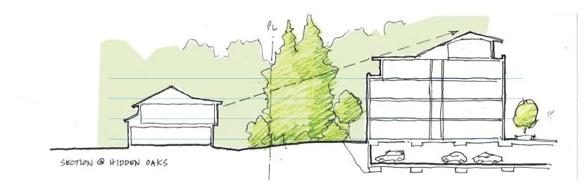
The applicant has provided a Public Engagement Summary Report showing the engagement with affected neighbours, including the Hidden Oaks residents. The applicant has shown that they are listening to the residents, and the emergent design is more sensitive to those concerns regarding screening, height, and density. The supplied interface cross-sections show the treatment of the interface at Hidden Oaks which includes an increased setback and open space between the buildings, and the addition of a stepped building from 4 to 5 storeys to minimize the visual impact of the partial fifth storey.
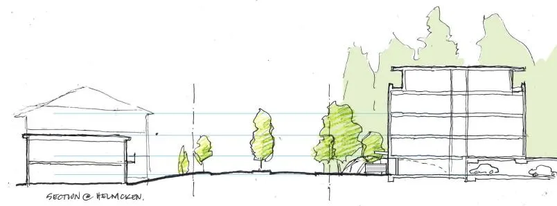
For the residents across Helmcken Road, the change in height is modest.
ANALYSIS AND DISCUSSION
The 2018 proposal for the site was rejected by Committee of the Whole largely due to the expression of the density (1.57 FSR) on the site. The Committee felt the visual impact was not satisfactory at either the Burnside/Helmcken intersection, or the interface between the site and the Hidden Oaks townhouse complex to the southwest.
The applicant has responded with a proposal for 1.5 FSR in a three-building configuration which is the product of staff and Council’s input, and the applicant’s public engagement process.
Design Critique
The design is much improved over the previous four-building design. The stepped, terraced and articulated massing addresses the interfaces in a much more appealing and sensitive way, and in staff’s opinion is as reasonable as can be expected while maintaining a density (1.5 FSR) close to the maximum indicated in the Official Community Plan’s Mixed Residential Land Use Designation (1.6 FSR).
The proposal of 22 three-bedroom condominiums is particularly attractive in that there is a significant need for more affordable family-friendly attached units.
The proposed interior concept is also much improved, with a sense of shared space and a pedestrian-prioritized environment which will also accommodate surface traffic and, with some tweaking, the requirements of the Town’s Protective Services Department.
Further design consideration will be available to Council at the Mixed Residential Form and Character Development Permit stage in the future.
Bylaw No. 900, 2014 Amendment Bylaw No. 1050, 2020
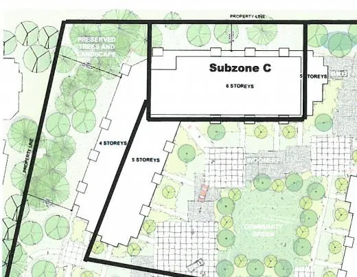
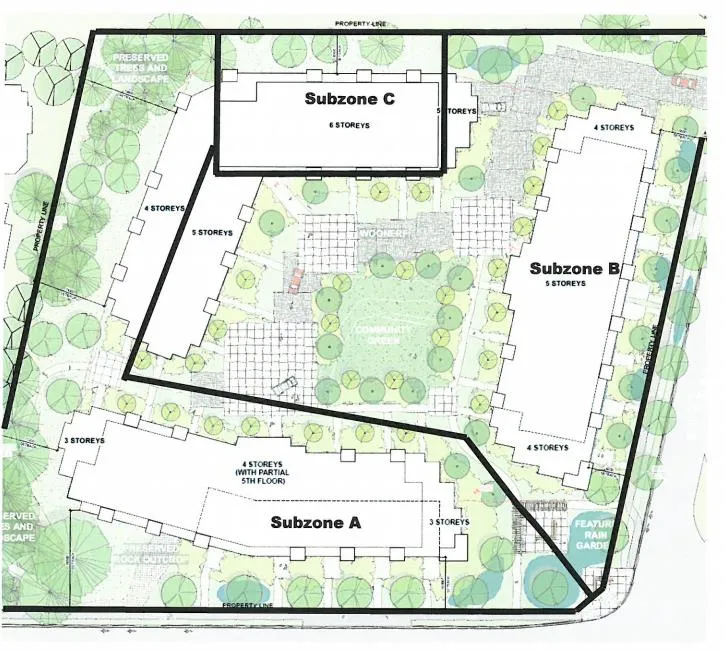
The bylaw to rezone the property divides the site into three sub-zones to ensure that the building heights proposed by the applicants are preserved in the bylaw.
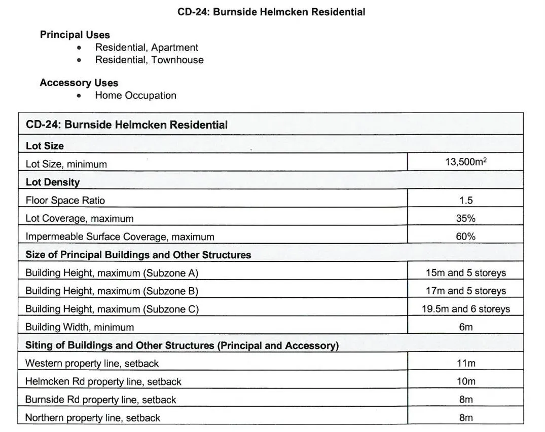
CD-24: Burnside Helmcken Residential
Principal Uses
- Residential, Apartment
- Residential, Townhouse
Accessory Uses
- Home Occupation
| CD-24: Burnside Helmcken Residential | |
|---|---|
| Lot Size | |
| Lot Size, minimum | 13,500m² |
| Lot Density | |
| Floor Space Ratio | 1.5 |
| Lot Coverage, maximum | 35% |
| Impermeable Surface Coverage, maximum | 60% |
| Size of Principal Buildings and Other Structures | |
| Building Height, maximum (Subzone A) | 15m and 5 storeys |
| Building Height, maximum (Subzone B) | 17m and 5 storeys |
| Building Height, maximum (Subzone C) | 19.5m and 6 storeys |
| Building Width, minimum | 6m |
| Siting of Buildings and Other Structures (Principal and Accessory) | |
| Western property line, setback | 11m |
| Helmcken Rd property line, setback | 10m |
| Burnside Rd property line, setback | 8m |
| Northern property line, setback | 8m |
The applicant has also included a relative height illustration (included in the attachments) indicating building heights at Eagle Creek Village (which are higher than the proposed here).
Conditions of Rezoning
In advance of adoption of the bylaw to rezone the property (should Council approve the bylaw), the following must happen:
- The Ministry of Transportation and Infrastructure must approve the bylaw as the property is within 800m of a controlled access intersection (Helmcken and Trans Canada).
- A covenant between the Town and the applicant must be undertaken to ensure that the $3,500 Community Amenity Contribution per additional detached residential unit will be paid.
- A covenant between the Town and the applicant must be undertaken to ensure that the tenant compensation as outlined in this report will be paid.
- A covenant between the Town and the applicant must be undertaken to ensure that the four subject parcels be consolidated into one parcel.
CONCLUSION
This application is much improved over the previous and is supported by staff. The proposal addresses the Northern Gateway condition within the OCP by providing an attractive entry feature to View Royal, it addresses the need for housing close to the hospital, to the regional pathway system, and to amenities at Eagle Creek Village. It is sensitive to the residential and agricultural interfaces, it provides a range of housing suitable for individuals and families alike, and generally represents a balance between realizing the densities described within the Mixed Residential OCP Land Use Designation while being sensitive to the existing surrounding uses.
RECOMMENDATION
THAT the report from the Community Planner dated June 10, 2020 titled “Rezoning – 3, 5 and 9 Helmcken Road and 1449 Burnside Road West (Eagles Nest)” be received for information.
ATTACHMENTS:
- Subject Property Map
- Subject Property Orthophoto
- Rezoning Application Submission Summary Document – Applicant – January 17, 2020
- Architectural Drawings – de Hoog & Kierulf architects – January 22, 2020
- Civil Engineering Drawings – McElhanney Consulting Services Ltd. – January 23, 2020
- Landscape Drawings – Murdoch DeGreeff – January 22, 2020
- Survey Plan – McElhanney Consulting Services Ltd. – February 23, 2018
- Letter to Mayor and Council – January 19, 2020
- Community Engagement Summary – March 4, 2020
- Stormwater Management Plan – September 13, 2018
- Traffic Impact Assessment – WATT Consulting Group – January 10, 2019
- Tree Preservation Plan – September 14, 2018
- Phase 1 ESA Report - McElhanney Consulting Services Ltd. – March 8, 2018
- Parking Study - Watt Consulting Group – September 14, 2018
- Helmcken Road Report – Watt Consulting Group - March 27, 2019
- Geotechnical Memo – Ryzuk Geotechnical – March 9, 2018
- Limited Hazardous Materials Investigation – Island Environmental Health & Safety Ltd. - March 20, 2018
- Helmcken & Burnside Tenant Relocation Matrix – Applicant - January 22, 2020
- Eagle’s Nest Development Data – Applicant - February 4, 2020
- Relative Height Illustration (Eagle Creek) – Applicant – Undated
- Bylaw No. 900, 2014 Amendment Bylaw No. 1050, 2020
Document Images
(6)