Phase I Environmental Site Assessment (ESA) located at Helmcken Road & Burnside Road W
Environmental assessment report identifying potential environmental concerns at the site, specifically focusing on historical heating oil tanks.
Phase I Environmental Site Assessment (ESA) located at Helmcken Road & Burnside Road W, View Royal, BC
Prepared for Highstreet Ventures Inc. 702 – 1708 Dolphin Ave Kelowna, BC V1Y 9S4
Prepared by McElhanney Consulting Services Ltd. 500-3960 Quadra Street Victoria, BC V8X 4A3
Contact: Sandra Hemstock Tel: 778-746-7519 Email: shemstock@mcelhanney.com
March 8, 2018
Executive Summary
McElhanney Consulting Services Ltd. (McElhanney) was retained by the Highstreet Ventures Inc. (the Client) to conduct a Phase I Environmental Site Assessment (Phase I ESA) for several properties located near the intersection of Helmcken Road and Burnside Road West in View Royal, BC (the Site). A comprehensive review of historical records was completed for the Site and surrounding adjacent properties. Visual observations were made of land at and adjacent to the Site.
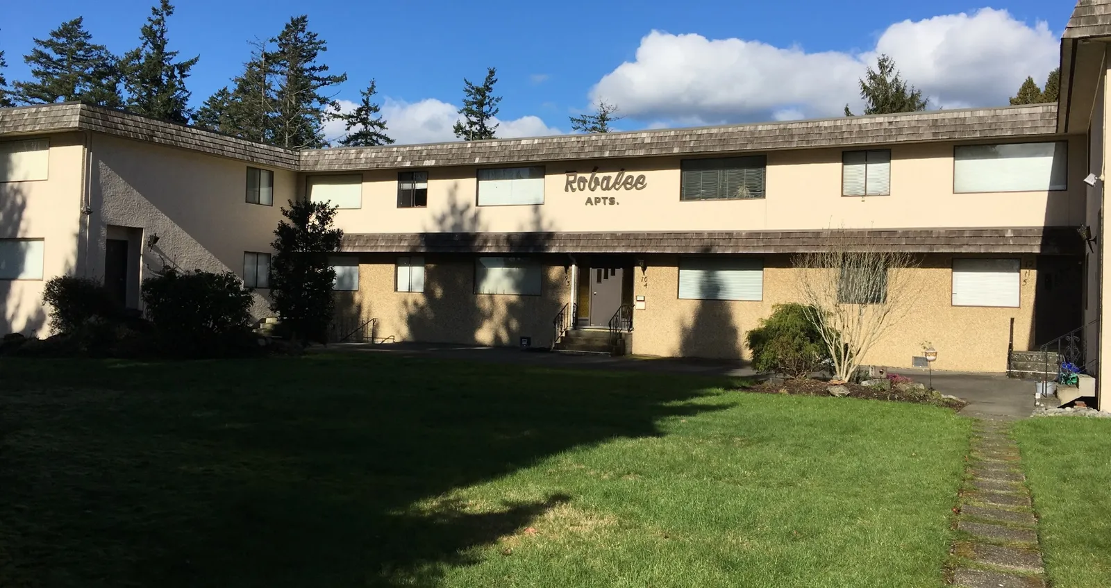
The Site was first developed in the 1940s and land use at the time included a single residential home and cattle pasture/agricultural land. The Site and neighbouring land to the north and east have been owned and occupied by the Henson family since the 1950s. Additional single-family residential homes were built in the 1950s and 1960s. The Henson family also constructed and managed a 12-unit apartment building on-Site in 1970. Members of the Henson family continue to reside in several homes in the area but primarily rent the residencies on the Site to various tenants.
The Henson family has also operated contracting businesses on the Site. The first was Henson W Building Contractors which owned by William Henson and operated out of the home at 1449 Burnside Rd W from around 1969 to the mid-1970s. The business then moved to a newly constructed home at 1480 Burnside Rd W (north of the Site) and was in operation until the early 1990s. The second contracting business is owned and operated by Julie and Robert Henson (J&R Henson Construction Ltd). For a period, they operated a plant nursery on the Site (circa 2005). The business also brought soil materials onto the northwest portion of the Site to be segregated and reused in landscaping (i.e. top soils, field stones and woody debris were separated on Site into various stockpiles).
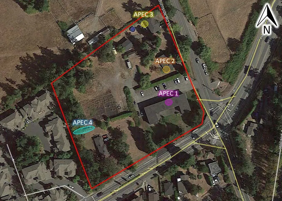
It is McElhanney’s opinion that, based on the findings of this Phase I ESA, historical and current activities present a potential risk of impacting environmental media at the Site and further environmental investigation is warranted. Based on our assessment of the Site, four areas of potential environmental concern (APEC) were identified that require further investigation and is presented in the below table and figure summarized from the text.
Table: Areas of potential environmental concern
| Area of Potential Environmental Concern | Description |
|---|---|
| APEC 1 | #3 Helmcken Rd Approximately 1000 L heating oil tank. Small stains noted under the tank, gravel floor is directly adjacent to the AST providing a pathway for potential contamination to enter the subsurface. |
| APEC 2 | 1445 Burnside Rd W abandoned home heating oil AST in the crawlspace on the southwest corner of the building (size could not be determined, but greater than 1000L) |
| APEC 3 | 1449 Burnside Rd W 1000 L heating oil tank located on the northwest corner of the building. The original tank was leaking as was replaced with the current tank. |
| APEC 4 | #5 Helmcken Rd poor housekeeping in the yard to the north of the house included disposal of a kerosene container, a 205 L steel drum of unknown contents and several other chemical containers inferred to be for lawn care and/or general home maintenance. |
Staff Recommendations:
A limited Phase II Environmental Site Assessment (Limited Phase II ESA) is recommended to quantitatively assess surficial soils at the identified APEC locations. The collected soil samples would be analyzed by an accredited laboratory. Potential contaminants of concern will be determined during the planning stages of the Phase II ESA.
Table of Contents
- Introduction .................................................................................................................................................... 1
- Assessment Methodology ........................................................................................................................... 4
- Records Review ........................................................................................................................................... 5 3.1 Environmental Setting ......................................................................................................................... 5 3.1.1 Precipitation ............................................................................................................................................ 5 3.1.2 Water Resources ..................................................................................................................................... 5 3.1.3 Surficial Geology ..................................................................................................................................... 6 3.2 Previous Environmental Reports ......................................................................................................... 7 3.3 ERIS Ecolog Database Searches ....................................................................................................... 7 3.3.1 Database Results within 250 m of Site Boundaries ................................................................................. 8 3.3.2 BC Ministry of Environment & Climate Change Strategy Site Registry Search ....................................... 8 3.3.3 Fire Insurance Plans ............................................................................................................................... 8 3.4 Aerial Photograph Interpretation ......................................................................................................... 8 3.5 Civic Directories ................................................................................................................................ 10
- Site Visit ....................................................................................................................................................... 12 4.1 Property Description .......................................................................................................................... 12 4.1.1 Topography, Fill Areas, and Local Geology .......................................................................................... 12 4.1.2 Buildings and Structures ....................................................................................................................... 13 4.1.3 Services and Utilities ............................................................................................................................. 13 4.1.4 Heating and Cooling Systems ............................................................................................................... 14 4.1.5 Mechanical Equipment .......................................................................................................................... 14 4.1.6 Underground Storage Tanks ................................................................................................................. 14 4.1.7 Above Ground Storage Tanks ............................................................................................................... 14 4.2 Exterior Observations ........................................................................................................................ 15 4.2.1 Surface Staining and Site Vegetation .................................................................................................... 15 4.2.2 Pits, Lagoons, Waste Water and Liquid Discharges .............................................................................. 15 4.3 Hazardous Materials and Special Attention Items ............................................................................ 15 4.3.1 Radon .................................................................................................................................................... 16 4.3.2 Polychlorinated Biphenyls (PCBs) ......................................................................................................... 16 4.3.3 Chemical Storage Containers ............................................................................................................... 16 4.4 Neighbouring Properties ................................................................................................................... 16 4.5 BC CSR Schedule 2 Activities .......................................................................................................... 17
- Interviews .................................................................................................................................................... 17 5.1.1 Mr. Robert Henson ................................................................................................................................ 17 5.1.2 Eddie Trembay ...................................................................................................................................... 17 5.1.3 Tracy Bruno ........................................................................................................................................... 18
- Summary and Conclusions ....................................................................................................................... 18
- Limitations of Report .................................................................................................................................. 19
- Professional Statement ............................................................................................................................. 21
Tables
Table 1. General Site Information ............................................................................................................................ 3 Table 2. Aerial Photograph Interpretation ................................................................................................................ 8 Table 3. Neighbouring Properties .......................................................................................................................... 16 Table 4. Areas of potential environmental concern ............................................................................................... 18
Figures
Figure 1. General Site Location (orange arrow) at Helmcken Road and Burnside Road W, View Royal, BC .. 1 Figure 2. Approximate Site Boundary (red outline) in View Royal, BC (ortho courtesy of Google Earth). Lots are outlined in yellow and civic addresses are bolded .............................................................................................. 2 Figure 3. BC ENV Water Resource Atlas 500 m radius search results (iMapBC 2018) ................................... 6 Figure 4. Excerpt from Relevant Soil Map of Vancouver Island – Victoria Saanich Sheet (BC6_map4) from Agriculture and Agri-Food Canada .......................................................................................................................... 7 Figure 5. Civic addresses at the Site and surrounding areas used in the public directory search ................. 11 Figure 6. Soil segregation activities historically occurring on the northwest portion of the Site ....................... 13 Figure 7. Areas of potential environmental concern ......................................................................................... 19
Appendices
A Select Site Photographs B Select Aerial Photographs C Land Titles D ERIS Ecolog Database Search Results E Opta Fire Insurance Records F Vancouver Public Library Civic Directories
1. Introduction
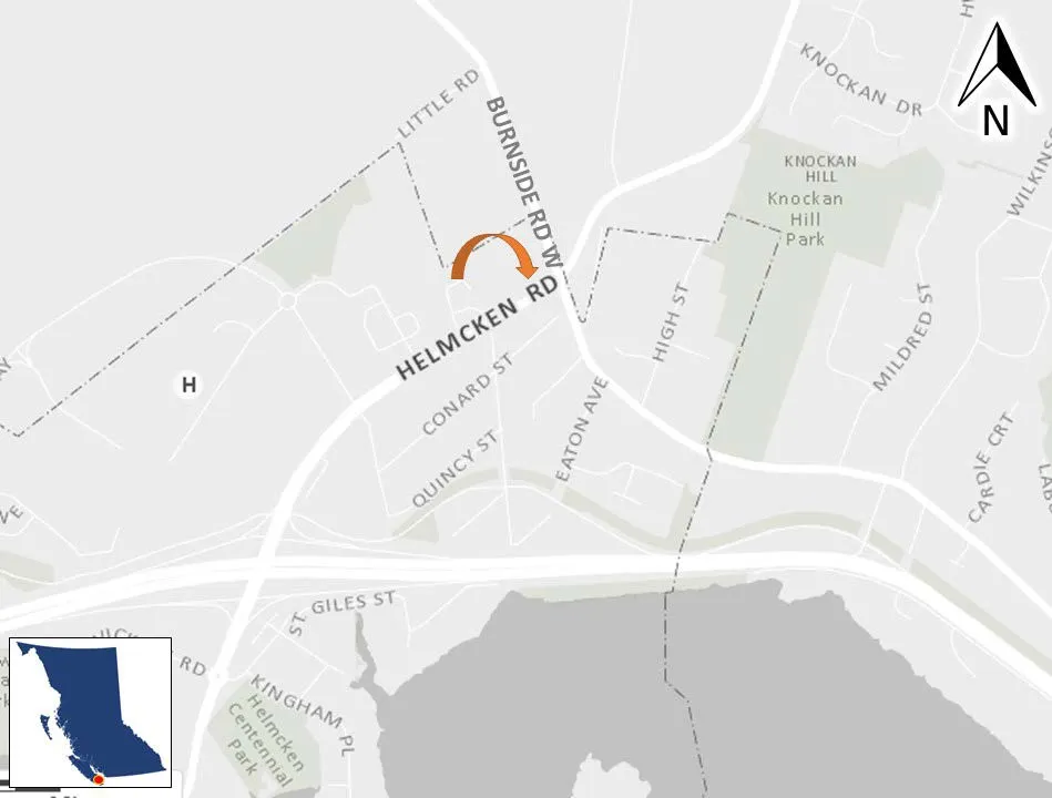
McElhanney Consulting Services Ltd. (McElhanney) was retained by Highstreet Ventures Inc. (the Client) to conduct a Phase I Environmental Site Assessment (Phase I ESA) for several properties located at the intersection of Helmcken Road and Burnside Road West in View Royal, BC (herein referred to as #3 Helmcken Rd or the Site) (Figure 1 & Figure 2). This report presents the findings of the Phase I ESA.
General Property Information
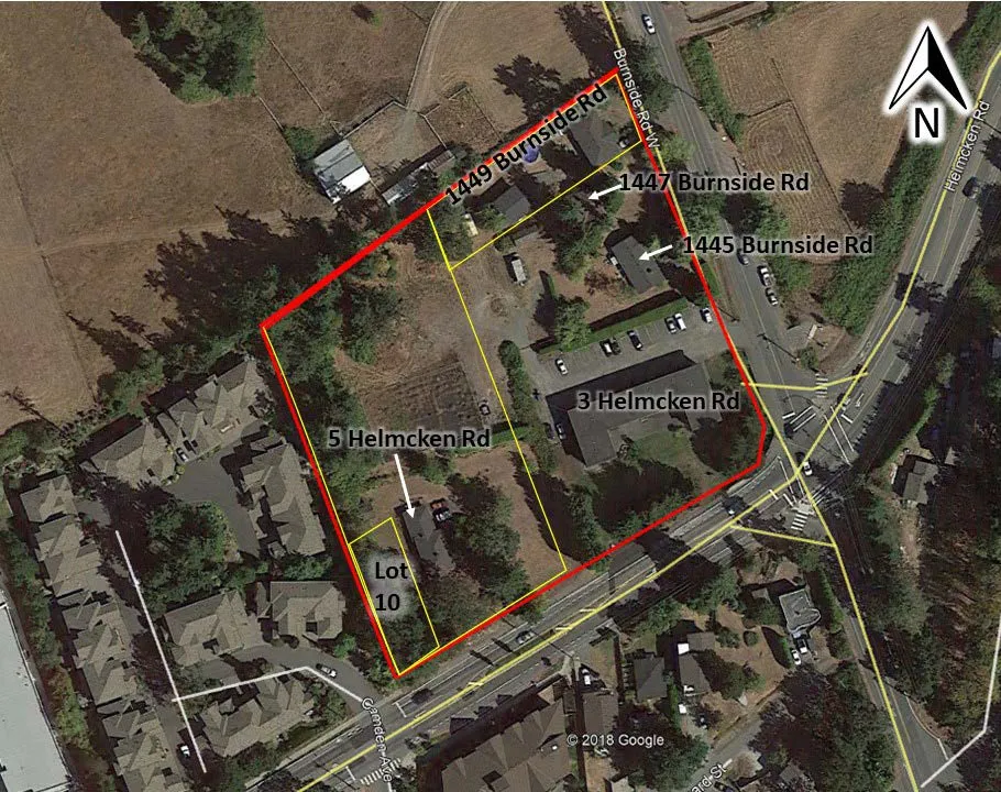
General Site information is summarized below in Table 1. Reconnaissance photographs of the Site and surrounding properties are included in Appendix A. Historical aerial photographs showing past land uses for the area are included in Appendix B. The Site is comprised of four single family residential homes, a twelve-unit apartment building and an area formerly used as a plant nursery. The Site is bounded by Helmcken Road to the south and Burnside Road W to the east. All lots on the Site are currently owned by the Henson family and have been so for multiple generations. Neighbouring properties to the north and east are also owned and occupied by the Henson family. The current land use proposal is to remove all existing buildings for Site redevelopment. Land title information and plans are provided in Appendix C.
Table 1. General Site Information
| Site Civic Address | 3 Helmcken Rd (includes homes with addresses 1445 & 1447 Burnside Rd W) |
|---|---|
| 5 Helmcken Rd | |
| Lot 10 Helmcken Rd | |
| 1449 Burnside Rd W | |
| Legal Description | Lot 1 Plan VIP3963 Section 9 Land District 21 Except Plan 18753 |
| Lot 2 Plan VIP3963 Section 9 Land District 21 | |
| Lot 10, Block 5, Section 9, Esquimalt District, Plan 1726 | |
| Lot 1 Plan VIP18753 Section 9 Land District 21 | |
| Parcel Identifier Number (PID) | 000-295-981 |
| 006-114-946 | |
| 007-028-156 | |
| 000-300-365 | |
| Registered Land Owner | 000-295-981 – Julie and Robert Henson |
| 006-114-946 (5 Helmcken Rd)– J&R Henson Construction Ltd. | |
| 007-028-156 (Lot 10) – J&R Henson Construction Ltd. | |
| 000-300-365 (1449 Burnside Rd W)– Julie and Robert Henson | |
| Occupant | All buildings/homes are currently occupied by tenants |
| Current Use | Residential |
| Area | 1.33 Hectares (3.3 Acres) |
| Zoning | RM-1 (Ground-Oriented Multiple-Unit Residential) R-1 (Detached Residential – Large Lot) |
The current property owner is listed as the Julie and Robert Henson on two of the titles and J&R Henson Construction Ltd. on the other two titles. The entire Site is owned by the Henson family. A copy of the current title search has been provided in Appendix C. All four of the titles were recently registered (between 2016 to 2017) but the Henson family has owned the land since approximately the 1950s, it has transferred ownership through several family members over time.
Site contamination issues, if listed on a title search, are most often found in Section 219 Covenants. A Section 219 covenant was not listed on the current title search for the Site. Leases, title transfers or easements related to site contamination issues were absent in the current title search results.
2. Assessment Methodology
The scope of this assignment was to conduct a Phase I ESA in accordance with CSA Standard Z768-01 (Reaffirmed 2016). The objective of this Phase I ESA was to determine whether Areas of Potential Environmental Concern (APECs) are present at the Site due to current and/or historical on and off-site activities. The study was completed to qualitatively identify the risk of actual or potential contamination of environmental media (soil, surface water, groundwater or soil vapour) on or adjacent to the Site.
The following rationale was applied throughout the assessment to determine whether current or historical activities represent a potential environmental concern for the Site:
- BC Contaminated Sites Regulations (CSR) Schedule 2 Activities for commercial or industrial sites identified on or adjacent to the Site;
- The presence of a hazardous substances (including waste) storage or use on-Site;
- Indication that substances were inadequately handled or contained and a pathway to the receiving environment may be present;
- The use, storage, or handling of a substance of potential concern occurred consistently over a long period of time, or in sufficient quantities to be considered a potential concern; and
- Are identified off-site land uses of concern located in close enough proximity and topographic orientation to present a potential for the migration of contamination onto the Site.
The following specific tasks were undertaken:
- Review of relevant records including: historical environmental reports; a search of relevant Provincial and Federal databases; available fire insurance maps; and available historic aerial photographs for the Site;
- Completion of a site visit to review and document existing conditions of the Site and surrounding area;
- Interviews with individuals knowledgeable of Site conditions;
- A review of the current land title for items related to site contamination issues (most often found in Section 219 Covenants, and certain lease, title, easement information); and
- Preparation of this report documenting the findings, summarizing recommendations (if any) and stating the limitations of this study.
The findings contained in this Phase I ESA are partly based on information provided by others. Where possible, information obtained through interviews was cross referenced through other sources.
Sampling and analysis of environmental media (soil, groundwater, surface water, or soil vapour) was not undertaken as part of this study. The assessment included a search of regulatory databases as defined in Section 4. Searches included properties bordering all extents of the Site.
3. Records Review
Several historical records were reviewed to assess the environmental conditions and current or historical land use activities at the Site. The following sections summarize the findings of this review.
3.1 ENVIRONMENTAL SETTING
3.1.1 Precipitation
Climatic conditions at the Site were inferred based on data provided by Environment Canada, Canadian Climate Normals 1981-2010. Recorded precipitation data for the Victoria Francis Park station were considered representative of the Site based on their proximity to that station. Annual precipitation was 1029.3 mm with monthly average lows of 19.3 mm in July and highs of 204.2 mm in November.
3.1.2 Water Resources
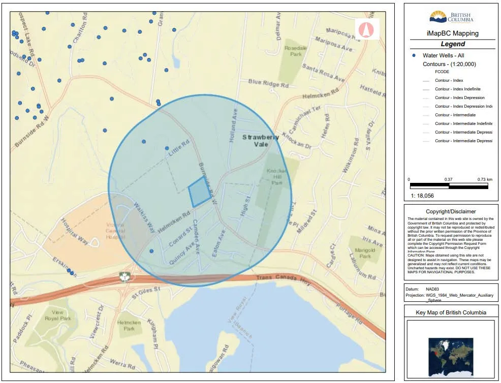
The iMapBC Water Resources layer, which is maintained by the Ministry of Environment & Climate Change Strategy (ENV), was used to create a map (Figure 3 below) depicting local topography, known water well locations, and surface water within a 500 m radius of the Site. This figure was used to infer groundwater flow direction.
Portage Inlet is located approximately 500 m south of the Site. Three water wells were identified within the 500 m search radius of the Site. The closest well (Well Tag # 34554) is 250 m north northwest of the Site and was constructed in 1976. Groundwater in this location was encountered at 41 meters below ground surface (mbgs).
Local topography suggests that the Site is on undulating ground which is approximately 30 m above sea level (masl). There is a hill to the east of the site in the area known as Strawberry Vale the summit of the hill is approximately 75 masl. There is a low point to the northwest of the Site with an elevation of approximately 14 masl. Based on the available information the groundwater flow direction is assumed to be south towards the Portage Inlet. Note that an intrusive Site-specific assessment of groundwater would be required to calculate actual groundwater flow direction.
3.1.3 Surficial Geology
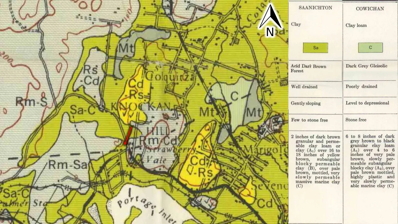
Soil Survey Reports for British Columbia are published by Agriculture and Agri-Food Canada. Available soil survey reports and maps for British Columbia were reviewed to determine surficial geology and soil types at the Site. Map 4-1959 Soil Map of Vancouver Island British Columbia – Victoria – Saanich Sheet was reviewed. The Site was classified as Saanichton-Cowichan soils which are clay to clay loam soils which are developed on fine-textured marine materials (Figure 4).
3.2 PREVIOUS ENVIRONMENTAL REPORTS
No previous environmental reports are known, and no reports were provided to McElhanney for review.
3.3 ERIS ECOLOG DATABASE SEARCHES
EcoLog Environmental Risk Information Services (ERIS) was retained to perform a 500 m search radius (from the edge of the Site) of the BC Ministry of Environment & Climate Change Strategy Site Registry (Site Registry) and a 250 m radius search of several additional environmental inventories and databases. The Site Registry is a data repository maintained by the BC ENV under the provisions of the Environmental Management Act (EMA) and Contaminated Sites Regulation (CSR) regarding information on activities with contamination causing potential.
It should be noted that ERIS provides a general database report which contains the most current information available for the databases reviewed. However, when registered sites are identified, an additional detailed site registry report is generated by ERIS which only provides information listed on the registry until 2012. To address the data gap between 2012 and the date of this assessment, BC Online was used (as necessary) to obtained detailed reports for relevant registered sites identified in the investigation.
3.3.1 Database Results within 250 m of Site Boundaries
There were no database listings for the Site property or the 250 m surrounding areas of the Site. There were no historical activities of concern identified through a review of historical databases. A copy of ERIS search results is provided in Appendix D.
3.3.2 BC Ministry of Environment & Climate Change Strategy Site Registry Search
There were no listings for the Site property or the surrounding area within the 500 m search radius.
3.3.3 Fire Insurance Plans
Historical fire insurance maps may provide insight into historical activities of a Site and they may document underground storage tanks or historical Site usage that may warrant environmental concern and/or further investigation. A search for available Fire Insurance Maps was conducted through ERIS/Opta. Fire insurance search results are provided in Appendix E. Results indicated that no fire insurance records were available for the Site area.
3.4 AERIAL PHOTOGRAPH INTERPRETATION
Historical aerial photographs were obtained from UBC’s Geographic Information Center and images from Google Earth. A selection of photographs available for review from the following years; 1932, 1946, 1956, 1968, 1974, 1980, 1986, 1997, 2005, 2010, 2014 and 2017. A summary of our review has been presented in Table 2 and copies of selected aerial photographs with a detailed review are provided in Appendix B.
Table 2. Aerial Photograph Interpretation
| Year | Photograph Reference | Site Area | Adjacent Properties |
|---|---|---|---|
| 1932 | A 4517 66 | The Site was primarily forested with the southern portion cleared along Helmcken Rd. | Helmcken Rd bound the Site and ended where it intersected with the Burnside Rd W at the southeast corner of the Site. Both roads appeared to be single lane gravel roads. There was agricultural land to the east, south and west. The property directly to the east had a single-family home and a dairy barn. |
| 1946 | BC 245 76 | Most of the forested vegetation had been removed and the Site converted to agricultural land. Near the northeast corner a single-family home was visible which currently is at address 1447 Burnside Rd W. | A few rural residential homes were visible to the south and both Helmcken Rd and Burnside Rd W had been upgraded. Holland Ave had been constructed to the east of the neighbouring barn. |
| 1956 | BC 2042 63 | The property appeared to have been subdivided with a hedge or fence running through the center (north south). A second single family residential home was visible on the southwest corner (5 Helmcken Rd). | Conrad Street had been constructed to the south. Holland Ave had been paved. Residential development had increased to the south. |
| 1968 | BC 5284 153 | The residential home at 1449 Burnside Rd W on the northeast corner had been built. The home at 1445 Burnside Rd W was under construction. | The lot to the north had a residential home and a building consistent with a barn directly adjacent to the northern boundary. |
| 1974 | BC 5568 0082 | The apartment building on the southeast corner of the Site was visible (#3 Helmcken Rd). A third residential home had been built along the east of the Site off Burnside Rd W (1445 Burnside Rd W). To the west of the houses was a building consistent with a shed. | Observations were like 1968. |
| 1980 | 15 BC 80005 272 | A structure consistent with a shed had been removed and a building had been constructed on the north central part of the Site. | Helmcken Rd and Burnside Rd W had been upgraded and widened. |
| 1986 | FF 8606 70 | Observations were like 1980. | Helmcken Rd had been extended to the |
Document Images
(3)

