Microtremor Survey Memo
A geotechnical survey report assessing seismic site class and depth to bedrock at 3 and 5 Helmcken Road.
RYZUK GEOTECHNICAL ENGINEERING & MATERIALS TESTING 28 Crease Avenue Victoria, B.C. V8Z 1S3 Tel: 250-475-3131 Fax: 250-475-3611 mail@ryzuk.com
E-mail / Fax Memo Project No: 8-8658-1 Project: Proposed Residential Development - 3 & 5 Helmcken Road - View Royal, BC Client: Highstreet Ventures Inc Contact: Alice Arsenault Email / Fax No: aarsenault@highstreetliving.ca Date: March 9, 2018
Copy to: Dave Slobodan (daslobodan@highstreetliving.ca)
Microtremor Survey Memo
Further to our proposal, we attended the above referenced site on February 22, 2018, to carry out a non-invasive investigation to estimate depth to bedrock and determine a Seismic Site Class. This was done by assessing the depth to bedrock beneath the site using our Tromino geophysical instrument. The following summarizes the results of our investigation and our associated comments as such relate to the proposed development.
The site is roughly square in shape and is bounded by Burnside Road to the east and Helmcken Road to the south, with a multi-family residential complex to the west, and a single family residence with a large field and barn to the north. The site is approximately 13300 m² with three single family residences in the northeast corner and another in the southwest corner, a two-storey apartment building located in the southeast corner. The site slopes down from the western half to the south, north, and east edges of the site approximately 4 m, 1 m, and 1 m in relief, respectively. The site is mostly covered in grass with trees along the south and west edges and northwest corner, a bedrock outcrop in the southwest corner, an asphalt parking lot to the north of the apartment building, a fenced off area in the center of the western half of the site, and a rock and mortar retaining wall in the southeast corner.
Our investigation of the site consisted of a review of relevant file information from adjacent projects we have had past involvement. We also consulted regional maps showing surficial and bedrock geologies. We subsequently attended the site to conduct a micro-tremor survey which can be used to determine the natural frequency of the subsoil and estimate depth to bedrock.
The Tromino is a passive geophysical device that records minute ground waves (microtremors) which can then be correlated to provide an indication of depth to glacial till or bedrock. From these results, the shear wave velocity in the upper 30 m of soil, and the associated seismic site classification can be inferred. During our site attendance, we placed the Tromino at 14 locations within the site. Our analysis of the data from these locations suggests that glacial till or bedrock varies across site from at surface to 8 m depth (+/- 1 m). However, the bedrock surface in Victoria is known to be highly variable, and there is also a remote possibility that the Tromino instrument is detecting rock in a non-vertical direction that will cause the correlation of rock depth to be misleading.
Greater Victoria is situated in a region of very high seismicity. Considerable earthquake risk exists, stemming from our proximity to the Cascadia subduction zone and numerous more local faults in southwestern BC and northwestern Washington State.
It is noted that at the time of writing this report, the 2015 National Building Code has been published. Similarly, the 2015 NBC Seismic Hazard Calculation, which adopts new methods of calculating hazard values, has been released. Generally, British Columbia adopts the NBC two to three years after the publication date. It is anticipated that the adoption of the 2015 NBC in the form of the BC Building Code will occur sometime in 2018. As such, the seismic hazard values for Peak Ground Acceleration (PGA) and Spectral Acceleration are reported for both editions in anticipation of this change.
Based on observed and anticipated geological conditions at the site, the shear wave velocity in the upper 30 m (Vs³⁰) is expected to be between 360 and 760 m/s. This corresponds to a Site Classification for Seismic Site Response of 'C', in accordance with the current BC Building Code. However, depending on the final foundation design elevations, the site class may be adjusted to Site Class 'A'.
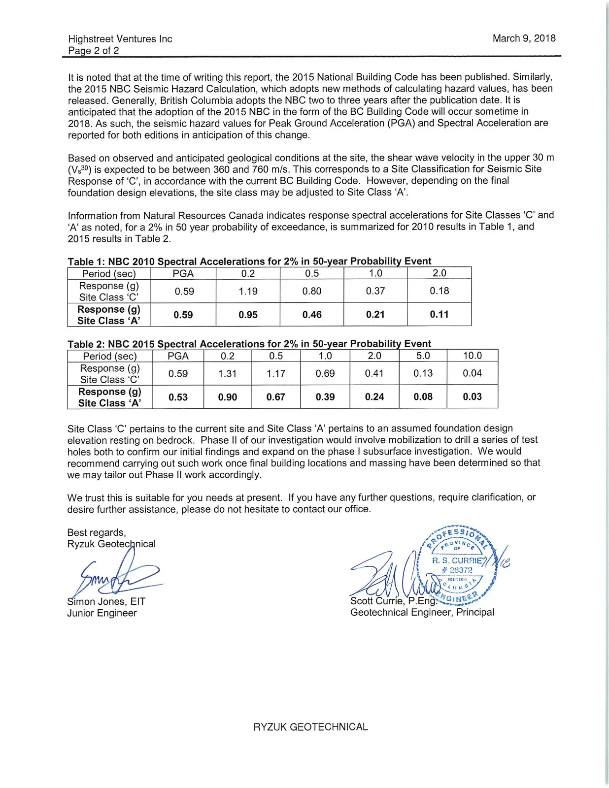
Information from Natural Resources Canada indicates response spectral accelerations for Site Classes 'C' and 'A' as noted, for a 2% in 50 year probability of exceedance, is summarized for 2010 results in Table 1, and 2015 results in Table 2.
Table 1: NBC 2010 Spectral Accelerations for 2% in 50-year Probability Event
| Period (sec) | PGA | 0.2 | 0.5 | 1.0 | 2.0 |
|---|---|---|---|---|---|
| Response (g) Site Class 'C' | 0.59 | 1.19 | 0.80 | 0.37 | 0.18 |
| Response (g) Site Class 'A' | 0.59 | 0.95 | 0.46 | 0.21 | 0.11 |
Table 2: NBC 2015 Spectral Accelerations for 2% in 50-year Probability Event
| Period (sec) | PGA | 0.2 | 0.5 | 1.0 | 2.0 | 5.0 | 10.0 |
|---|---|---|---|---|---|---|---|
| Response (g) Site Class 'C' | 0.59 | 1.31 | 1.17 | 0.69 | 0.41 | 0.13 | 0.04 |
| Response (g) Site Class 'A' | 0.53 | 0.90 | 0.67 | 0.39 | 0.24 | 0.08 | 0.03 |
Site Class 'C' pertains to the current site and Site Class 'A' pertains to an assumed foundation design elevation resting on bedrock. Phase II of our investigation would involve mobilization to drill a series of test holes both to confirm our initial findings and expand on the phase I subsurface investigation. We would recommend carrying out such work once final building locations and massing have been determined so that we may tailor out Phase II work accordingly.
We trust this is suitable for you needs at present. If you have any further questions, require clarification, or desire further assistance, please do not hesitate to contact our office.
Best regards, Ryzuk Geotechnical
Simon Jones, EIT Junior Engineer
Scott Currie, P.Eng. Geotechnical Engineer, Principal
Document Images
(2)