Arborist report for proposed 4 Lot subdivision of the properties at 256 and 258 Plowright Road (Attachment 6)
Technical report from Talbot Mackenzie & Associates assessing tree resources and potential impacts of development, including site plans and fencing details.
Talbot Mackenzie & Associates
Consulting Arborists
December 03, 2013
Ms. Lana Cabrilo 3832 Rowland Avenue Victoria, BC V8Z 1X9
Re: Arborist report for proposed 4 Lot subdivision of the properties at 256 and 258 Plowright Road
Assignment: Our assignment as discussed was to: review the proposed subdivision lot layout, servicing and driveway access and comment on the proposed layout as it relates to tree retention. Prepare a report summarising our findings, the potential impacts on the tree resource and the feasibility of tree retention on this site. Outline methods to mitigate the impacts of the construction on the trees that are to be retained, as it pertains to the lot subdivision stage (i.e. road and driveway access and servicing to the lot boundaries).
Method: For the purpose of this report we reviewed the subdivision drawings that were supplied and inspected the health and structural characteristics of the tree resource. The trees had been identified and tagged in the field by others and the information regarding the tree species and size (d.b.h) used for this report was obtained from a list that was provided to us. During our November 27, 2013 site visit and review of the tree resource, we observed additional trees and groups of trees that would be considered protected by species or by size that were not on the list that was provided to us and that had not been identified in the field with numbered tags. One of our attached spreadsheet lists the quantity of additional trees and their species makeup. Most of the additional trees grow in groups or hedgerows and have similar size and growth characteristics as the tagged trees on the property.
Tree Resource: The tree resource on the property is comprised of:
- A row of 2 Western Red cedar and 6 Douglas-fir trees that are located along the north side and near the east end of the existing driveway to 258 Plowright Road. The trees have health and structural characteristics that indicate that they may be suitable for retention. This row of trees is identified in the field with tag numbers, 436, 437, 448, 449, 452, 453, 454 and 455.
- Seven Garry oak trees that are located within the boundaries of proposed lot 3 and 4. The trees are identified in the field with tag numbers, 438, 439, 440, 441, 442, (443,444,445, a single tree with multiple stems), and 446. These oak trees, with the exception of #439, have health and structural characteristics that indicate that they may be suitable for retention. Oak #439 is showing evidence of health stress and structural defects, however it will be possible to retain this tree in the short term if the existing house and other features and buildings on the lot are retained undisturbed.
- The remainder of the trees on the property have been heavily topped or reduced historically and grow in hedgerows or groupings that are planted close together making them difficult to separate or retain as individual trees on the lots if the adjacent trees are removed. In our opinion none of these groups of topped trees would be considered suitable for retention on the lots, once developed.
Potential Impacts: Following our review of the site and the plans supplied, it is our opinion that the bylaw-protected trees could potentially be impacted as follows.
- The row or trees identified in item #1 above could potentially be impacted by the construction of the common driveway access and for the underground services proposed to run along the easement. A 2011 servicing drawing shows an existing sanitary drain that runs along the driveway easement and a new water main and storm sewer to be installed along this same easement. It is also our understanding that this is a registered BC Hydro right of way and would also be the logical place to run underground hydro and communications services and a gas service.
- The Garry oak trees indicated in item #2 above are located where they should not be impacted by the construction of the driveway access or the underground services. It should be possible to retain oaks numbered 438, 439, 440, 441 and 442 if the existing house and other features and buildings on the lot are retained on this lot. There is a greater potential to impact Garry oak #446 and the multiple stemmed oak (443, 444, 445) in order to located a building footprint on proposed lot #3. If the building footprint can be located toward the front of the lot and where it is outside its critical rooting areas, there may be an opportunity to retain one or more of these two oak trees.
- It is our opinion that it will be necessary to remove all of the rows and groups of topped trees that are located along the south side of the common driveway access to accommodate the driveways and the underground service corridors. It is also our opinion, as stated above, that these groups of topped trees are not considered suitable for retention on the lots, once developed.
Mitigation of impacts: The following are general recommendations to be implemented when construction activity encroaches within critical rooting areas of trees that are to be retained on a site, and to reduce the impacts on these trees.
Barrier fencing:
The areas, surrounding the trees to be retained on this property must be isolated from the construction activity by erecting protective barrier fencing. Where possible, the fencing should be erected at the perimeter of the critical root zones as defined in our tree resource spreadsheet. Where the building footprint and other features encroach within the critical root zone area, the fencing should be erected one metre off the edge of the building footprint and along the edge of the footprint for any servicing trenches.
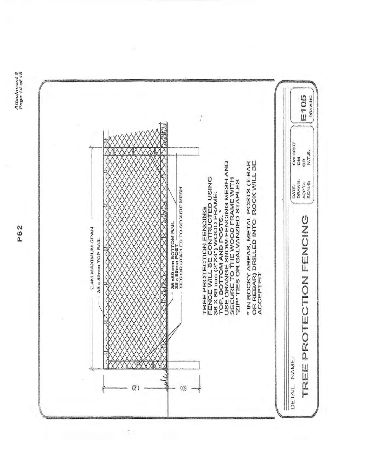
The barrier fencing to be erected must be a minimum of 4 feet in height, of solid frame construction that is attached to wooden or metal posts. A solid board or rail must run between the posts at the top and the bottom of the fencing. This solid frame can then be covered with plywood, or flexible snow fencing (see attached diagram).
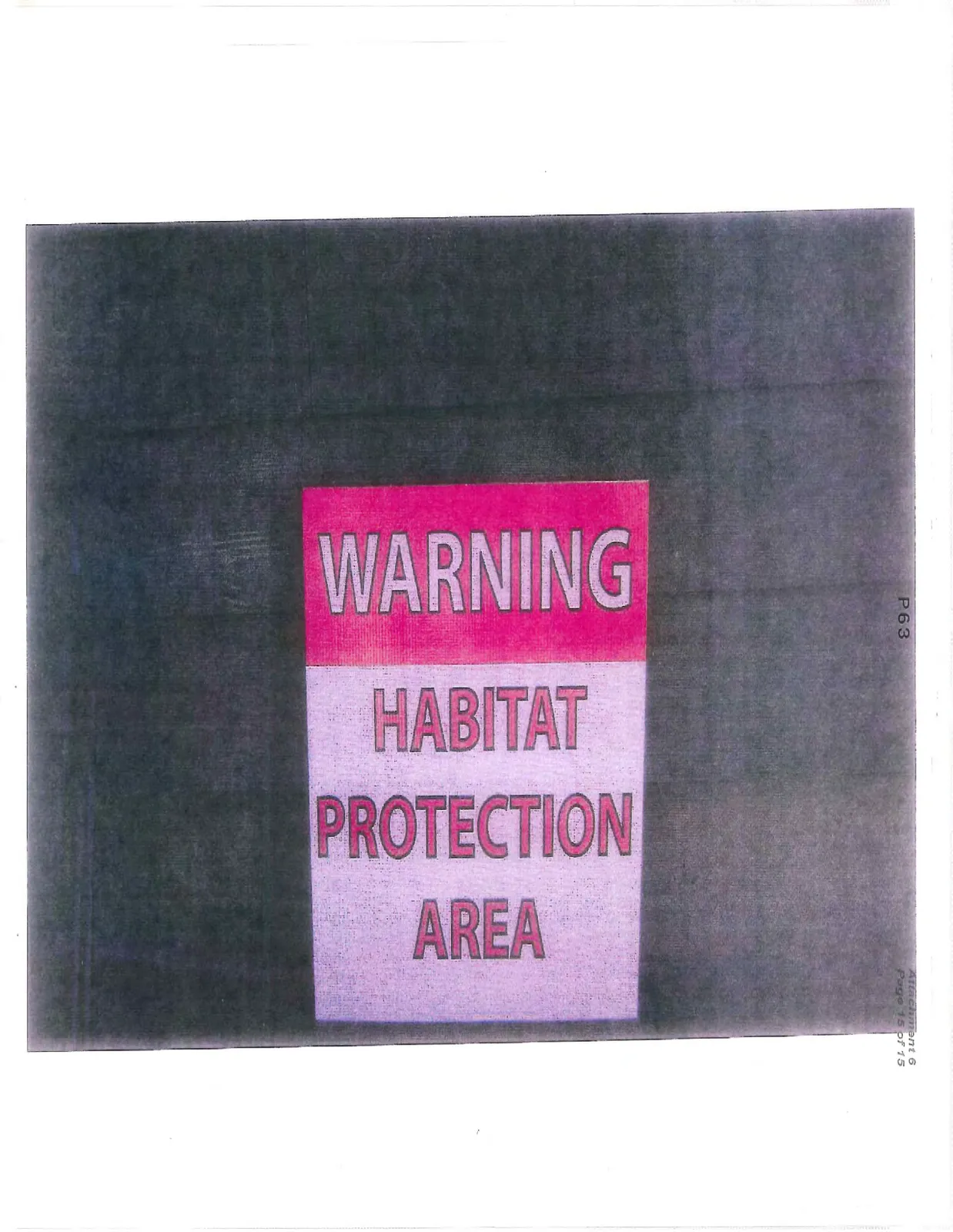
The fencing must be erected prior to the start of any construction activity on site (i.e. site clearing, demolition, excavation, construction), and remain in place through completion of the project. Signs must be posted around the protection zone to declare it off limits to all construction related activity. The project arborist must be consulted before this fencing is removed or moved for any purpose.
Building footprints:
The building footprints had not been defined for the individual lots at the time this report was prepared. Building footprints should be located, where they do not encroach within the critical root zones of trees that are to be retained or where such encroachment will not have a detrimental impact on the survival of the tree. It is important that any tree that is proposed for retention is adequately protected with barrier fencing prior to site clearing and the removal of trees from the building lots. It may not be possible to remove the stumps of trees that are to be removed from within the critical root zones of trees that are to be retained by use of an excavator or other excavating equipment. We recommend that stumps that are located in these critical areas be ground or routed below the soil surface and not removed by excavation in order to reduce the impacts on the neighbouring trees.
The project arborist must supervise the excavation for the building footprints, where they encroach on the root zones of the bylaw-protected oak trees.
Driveway footprint:
Portions of the proposed common access may encroach within the root zones of the row of Douglas-fir and cedar trees that are located along the north side of this driveway access. Locating the paved turnaround area at the east end of this driveway closer to the south side of this easement and maintaining an undisturbed strip of land between the pavement and the trees will reduce the impacts on this row of trees and improve their chance of survival. If any of this row of trees is retained, the project arborist must review the construction detail, determine which trees can be retained, and supervise any excavation that is required
Blasting and rock removal:
Areas of bedrock are located within the lots and may be located within building and driveway footprints and may also be present within the service corridors. The blasting to level these rock areas should be sensitive to the root zones located at the edge of the rock. Care must be taken to assure that the area of blasting does not extend into the critical root zones beyond the building footprint and the service corridors. The use of small low-concussion charges and multiple small charges will reduce fracturing, ground vibration, and reduce the impact on the surrounding environment. Only explosives of low phytotoxicity (stick dynamite), and techniques that minimize tree damage, are to be used within the critical root zones of the trees that are to be retained. Provisions must be made to store blast rock, and other construction materials and debris away from critical tree root zones. The project arborist must meet with the blasting contractor to review the blasting requirements and monitor the progress throughout the blasting phase.
Pruning:
It may be necessary to remove low limbs from trees that grow close to the service corridor or building footprints to attain adequate clearances. We recommend that any pruning of a bylaw-protected tree be completed by an ISA Certified Arborist.
Offsite work:
The plans did not show, and we are not aware of any upgrades or replacements of offsite municipal infrastructures. The project arborist must review any changes to the municipal infrastructure or additional offsite requirements prior to their installation to determine the impacts on the bylaw-protected trees that are to be retained.
Work Area and Material Storage:
It is important that the issue of storage of excavated soil, blast rock, construction materials, and site parking be reviewed prior to the start of construction; where possible, these activities should be kept outside of the critical root zones. If there is insufficient room for onsite storage and working room, the arborist must determine a suitable working area within the critical root zone, and outline methods of mitigating the associated impacts (i.e. mulch layer, bridging etc).
Arborist Role —
It is the responsibility of the client or his/her representative to contact the project arborist for the purpose of:
- Locating the barrier fencing
- Reviewing the report with the project foreman or site supervisor
- Locating work zones, where required
- Supervising excavation for the building, driveway and service footprints where they encroach within the critical root zones of trees that are to be retained.
- Review the blasting requirements with the blasting contractor and monitor its progress.
- Reviewing and advising of any pruning requirements for building or service clearances.
Review and site meeting:
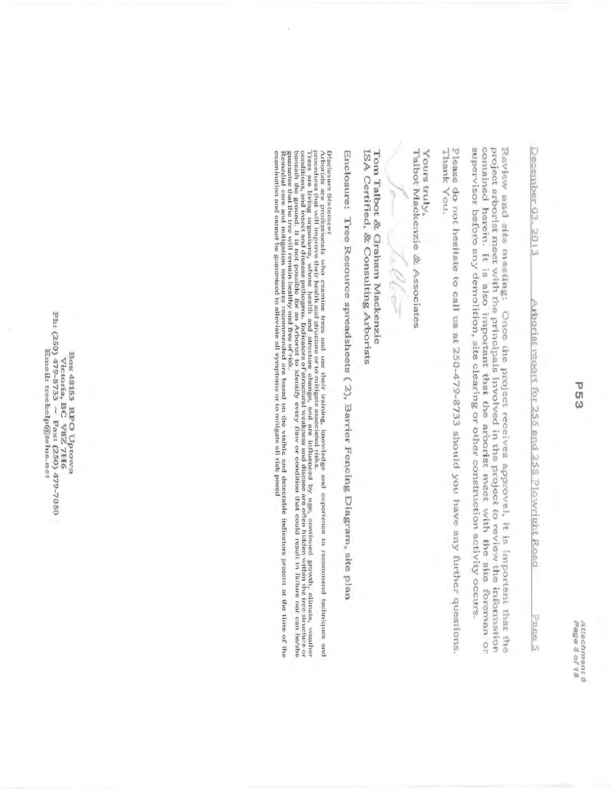
Once the project receives approval, it is important that the project arborist meet with the principals involved in the project to review the information contained herein. It is also important that the arborist meet with the site foreman or supervisor before any demolition, site clearing or other construction activity occurs.
Please do not hesitate to call us at 250-479-8733 should you have any further questions. Thank You.
Yours truly, Talbot Mackenzie & Associates
Tom Talbot & Graham Mackenzie ISA Certified, & Consulting Arborists
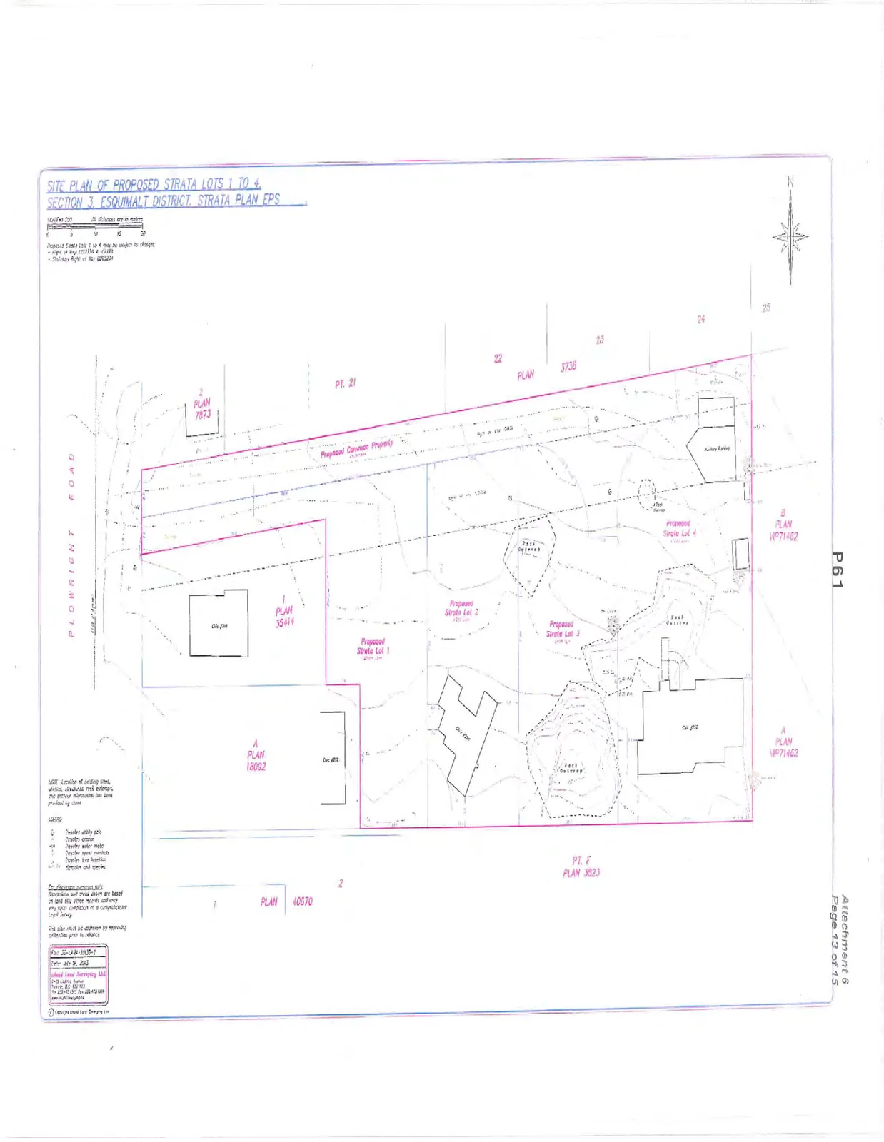
Enclosure: Tree Resource spreadsheets (2), Barrier Fencing Diagram, site plan
Disclosure Statement Arborists are professionals who examine trees and use their training, knowledge and experience to recommend techniques and procedures that will improve their health and structure or to mitigate associated risks. Trees are living organisms, whose health and structure change, and are influenced by age, continued growth, climate, weather conditions, and insect and disease pathogens. Indicators of structural weakness and disease are often hidden within the tree structure or beneath the ground. It is not possible for an Arborist to identify every flaw or condition that could result in failure nor can he/she guarantee that the tree will remain healthy and free of risk. Remedial care and mitigation measures recommended are based on the visible and detectable indicators present at the time of the examination and cannot be guaranteed to alleviate all symptoms or to mitigate all risk posed
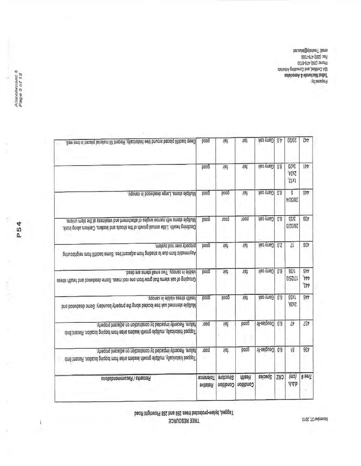
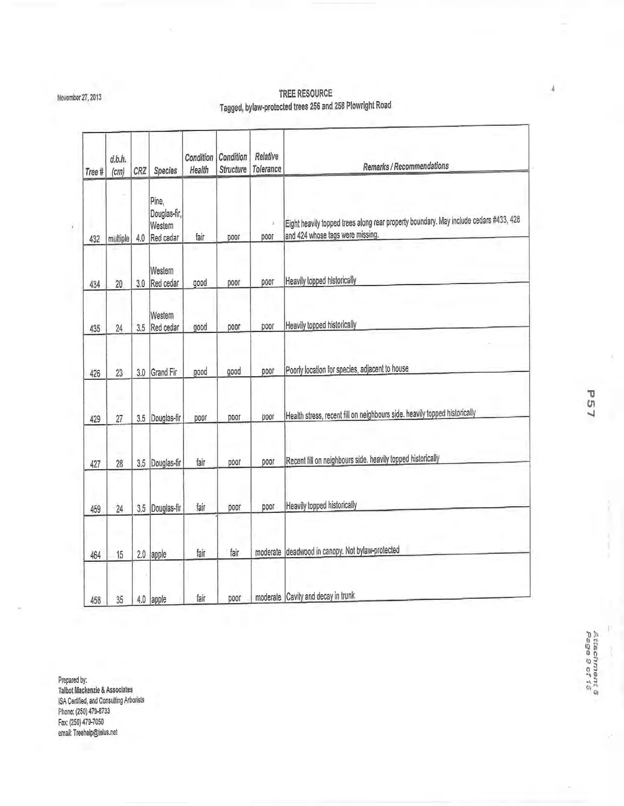
TREE RESOURCE
Tagged, bylaw-protected trees 256 and 258 Plowright Road November 27, 2013
| Tree # | d.b.h. (cm) | CRZ | Species | Condition Health | Condition Structure | Relative Tolerance | Remarks / Recommendations |
|---|---|---|---|---|---|---|---|
| 436 | 51 | 6.0 | Douglas-fir | good | fair | poor | Topped historically, multiple growth leaders arise from topping location. Recent limb failure. Recently impacted by construction on adjacent property. |
| 437 | 47 | 6.0 | Douglas-fir | good | fair | poor | Topped historically, multiple growth leaders arise from topping location. Recent limb failure. Recently impacted by construction on adjacent property. |
| 446 | 2x28, 1x33 | 6.0 | Garry oak | fair | good | good | Multiple stemmed oak tree located along the property boundary. Some deadwood and health stress visible in canopy. |
| 443, 444, 445 | 17/25/31/38 | 8.0 | Garry oak | fair | fair | good | Grouping of oak stems that grow from one root mass. Some deadwood and health stress visible in canopy. Two small stems are dead. |
| 438 | 17 | 2.0 | Garry oak | fair | fair | good | Asymmetric form due to shading from adjacent tree. Some backfill from neighbouring property over root system. |
| 439 | 26/32/33/33 | 8.0 | Garry oak | poor | poor | good | Declining health. Little annual growth of the shoots and leaders. Cankers along trunk. Multiple stems with narrow angles of attachment and weakness at the stem unions. |
| 440 | 28/30/45 | 8.0 | Garry oak | fair | good | good | Multiple stems. Large deadwood in canopy. |
| 441 | 1x12, 2x24, 3x20 | 8.0 | Garry oak | fair | fair | good | |
| 442 | 20/20 | 4.0 | Garry oak | fair | fair | good | Deep backfill placed around tree historically. Recent fill material placed in tree well. |
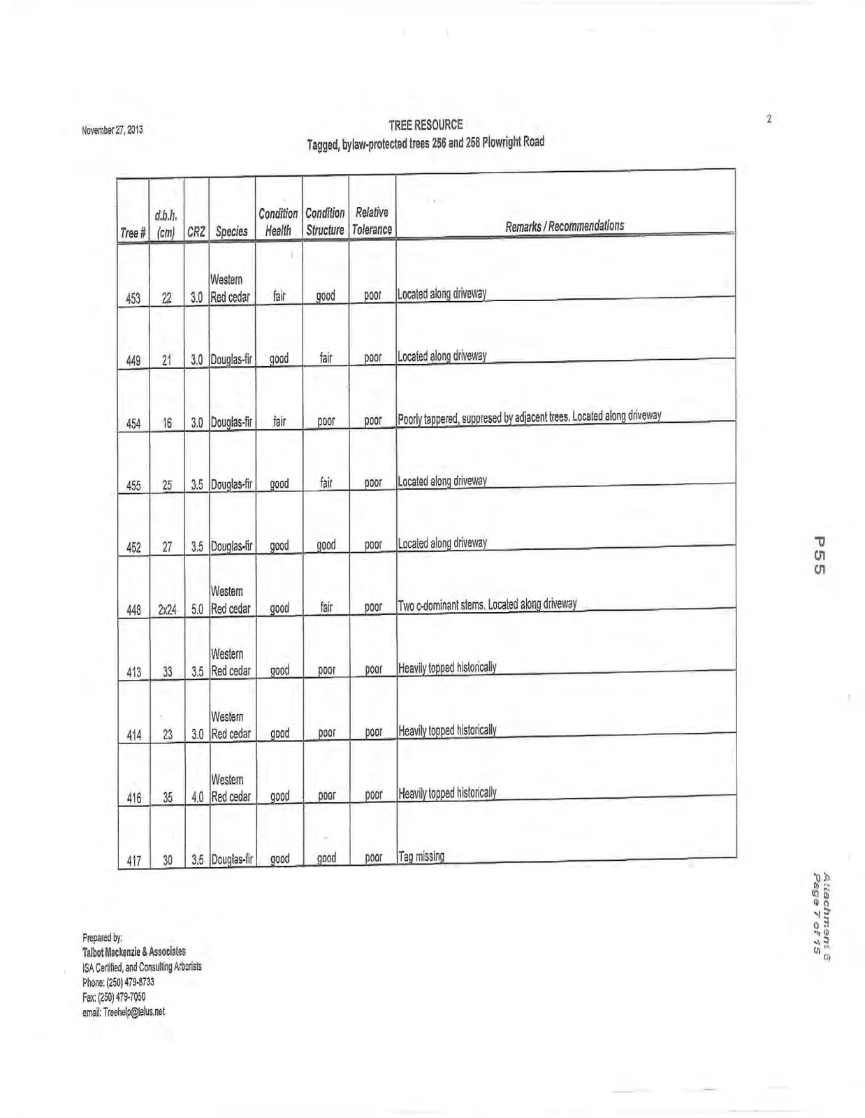
| 453 | 22 | 3.0 | Western Red cedar | fair | good | poor | Located along driveway |
| 449 | 21 | 3.0 | Douglas-fir | good | fair | poor | Located along driveway |
| 454 | 16 | 3.0 | Douglas-fir | fair | poor | poor | Poorly tappered, suppressed by adjacent trees. Located along driveway |
| 455 | 25 | 3.5 | Douglas-fir | good | fair | poor | Located along driveway |
| 452 | 27 | 3.5 | Douglas-fir | good | good | poor | Located along driveway |
| 448 | 2x24 | 5.0 | Western Red cedar | good | fair | poor | Two c-dominant stems. Located along driveway |
| 413 | 33 | 3.5 | Western Red cedar | good | poor | poor | Heavily topped historically |
| 414 | 23 | 3.0 | Western Red cedar | good | poor | poor | Heavily topped historically |
| 416 | 35 | 4.0 | Western Red cedar | good | poor | poor | Heavily topped historically |
| 417 | 30 | 3.5 | Douglas-fir | good | good | poor | Tag missing |
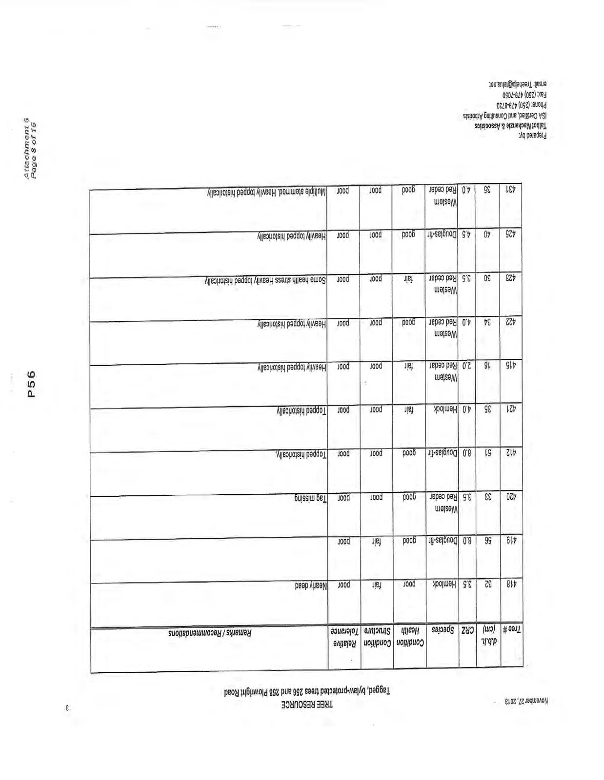
| 418 | 32 | 3.5 | Hemlock | poor | fair | poor | Nearly dead |
| 419 | 56 | 8.0 | Douglas-fir | good | fair | poor | |
| 420 | 33 | 3.5 | Western Red cedar | good | poor | poor | Tag missing |
| 412 | 51 | 8.0 | Douglas-fir | good | poor | poor | Topped historically |
| 421 | 35 | 4.0 | Hemlock | fair | poor | poor | Topped historically |
| 415 | 18 | 2.0 | Western Red cedar | fair | poor | poor | Heavily topped historically |
| 422 | 34 | 4.0 | Western Red cedar | good | poor | poor | Heavily topped historically |
| 423 | 30 | 3.5 | Western Red cedar | fair | poor | poor | Some health stress Heavily topped historically |
| 425 | 40 | 4.5 | Douglas-fir | good | poor | poor | Heavily topped historically |
| 431 | 35 | 4.0 | Western Red cedar | good | poor | poor | Multiple stemmed. Heavily topped historically |
| 432 | multiple | 4.0 | Pine, Douglas-fir, Western Red cedar | fair | poor | poor | Eight heavily topped trees along rear property boundary. May include cedars #433, 428 and 424 whose tags were missing. |
| 434 | 20 | 3.0 | Western Red cedar | good | poor | poor | Heavily topped historically |
| 435 | 24 | 3.5 | Western Red cedar | good | poor | poor | Heavily topped historically |
| 426 | 23 | 3.0 | Grand Fir | good | good | poor | Poorly location for species, adjacent to house |
| 429 | 27 | 3.5 | Douglas-fir | poor | poor | poor | Health stress, recent fill on neighbours side. heavily topped historically |
| 427 | 28 | 3.5 | Douglas-fir | fair | poor | poor | Recent fill on neighbours side. heavily topped historically |
| 459 | 24 | 3.5 | Douglas-fir | fair | poor | poor | Heavily topped historically |
| 464 | 15 | 2.0 | apple | fair | fair | moderate | deadwood in canopy. Not bylaw-protected |
| 458 | 35 | 4.0 | apple | fair | poor | moderate | Cavity and decay in trunk |
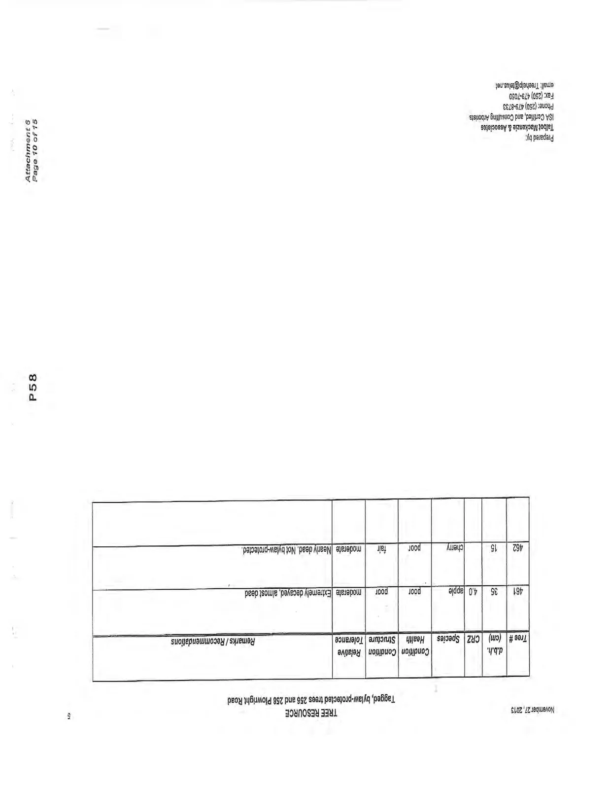
| 461 | 35 | 4.0 | apple | poor | poor | moderate | Extremely decayed, almost dead |
| 462 | 15 | cherry | poor | fair | moderate | Nearly dead. Not bylaw-protected. |
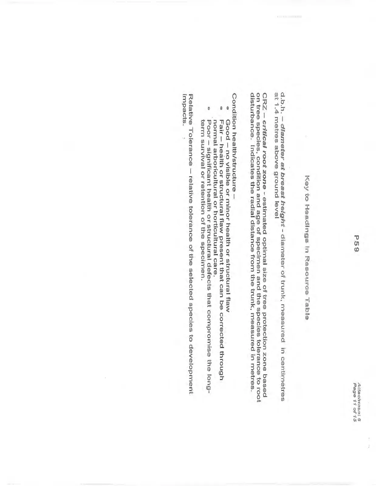
Key to Headings in Resource Table
d.b.h. – diameter at breast height - diameter of trunk, measured in centimetres at 1.4 metres above ground level CRZ – critical root zone - estimated optimal size of tree protection zone based on tree species, condition and age of specimen and the species tolerance to root disturbance. Indicates the radial distance from the trunk, measured in metres. Condition health/structure —
- Good – no visible or minor health or structural flaw
- Fair – health or structural flaw present that can be corrected through normal arboricultural or horticultural care.
- Poor – significant health or structural defects that compromise the long-term survival or retention of the specimen. Relative Tolerance — relative tolerance of the selected species to development impacts.
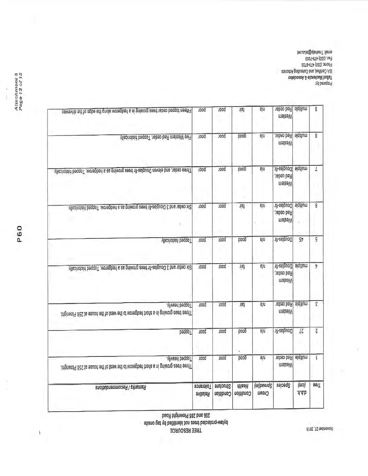
TREE RESOURCE
bylaw-protected trees not identified by tag onsite 256 and 258 Plowright Road November 27, 2013
| Tree | d.b.h. (cm) | Crown Spread(m) | Species | Condition Health | Condition Structure | Relative Tolerance | Remarks / Recommendations |
|---|---|---|---|---|---|---|---|
| 1 | multiple | n/a | Western Red cedar | good | poor | poor | Three trees growing in a short hedgerow to the west of the house at 258 Plowright. Topped heavily. |
| 2 | 27 | n/a | Douglas-fir | good | poor | poor | Topped |
| 3 | multiple | n/a | Western Red cedar | fair | poor | poor | Three trees growing in a short hedgerow to the west of the house at 258 Plowright. Topped heavily. |
| 4 | multiple | n/a | Western Red cedar, Douglas-fir | fair | poor | poor | Six cedar and 3 Douglas-fir trees growing as a hedgerow. Topped historically. |
| 5 | 45 | n/a | Douglas-fir | good | poor | poor | Topped historically |
| 6 | multiple | n/a | Western Red cedar, Douglas-fir | fair | poor | poor | Six cedar and 3 Douglas-fir trees growing as a hedgerow. Topped historically. |
| 7 | multiple | n/a | Western Red cedar, Douglas-fir | good | poor | poor | Three cedar, and eleven Douglas-fir trees growing as a hedgerow. Topped historically. |
| 8 | multiple | n/a | Western Red cedar | good | poor | poor | Five Western Red cedar. Topped historically |
| 9 | multiple | n/a | Western Red cedar | fair | poor | poor | Fifteen topped cedar trees growing in a hedgerow along the edge of the driveway |
THIS PAGE LEFT BLANK INTENTIONALLY
Document Images
(13)