Staff Report (Historical): Development Permit Application 2014/04 - June 6, 2014
Report to the Committee of the Whole regarding the retaining wall construction breach.
TO: Committee of the Whole DATE: June 6, 2014 FROM: Jeff Chow, Senior Planner MEETING: June 10, 2014 FILE NO: 3060-20-2014-04
ENVIRONMENTAL DEVELOPMENT PERMIT APPLICATION 2014/04 - 237 Anya Lane
RECOMMENDATION:
That the June 6, 2014 report from the Senior Planner titled “Environmental Development Permit Application 2014/04 – 237 Anya Lane” be received.
CHIEF ADMINISTRATIVE OFFICER'S COMMENTS:
I concur with the recommendation.
DIRECTOR OF DEVELOPMENT SERVICES' COMMENTS:
I concur with the recommendation.
PURPOSE
The purpose of this report is to introduce an Environmental Development Permit application to amend Development Permit 2012/07 in order to permit a retaining wall that has already been constructed. A variance is necessary to permit part of the retaining wall located within 15.0 m of the natural boundary to be up to 2.8 m high (2.0 m maximum permitted).
BACKGROUND
The 0.41 ha single family residential parcel is part of the Parson's Cove bare land strata subdivision that was registered in 2004. The site is located near the intertidal interface of Millstream Creek and Esquimalt Harbour and is separated from the shoreline by Duffus Trail Park, which is a linear park that ranges from 6.5 to 8.0 m wide. A conservation covenant EW086820 (Attachment 3) was registered at the time of subdivision to preserve land within 15 metres of the natural boundary in a natural state. A 4.0 m wide statutory right-of-way along the west property line was also registered to provide a public pedestrian connection through the property between Anya Lane and Duffus Trail Park, though it is currently too steep for safe use.
The site slopes from the end of Anya Lane down almost 10 metres to a lower field. The lower field and adjacent linear park appears to have been formed by soil deposition as Millstream Creek meandered over time and water levels dropped. The field was used to grow agronomic grasses for farm purposes, although invasive species were encroaching. There are several trees on the slope, including a central stand of mature maple trees retained by the applicant.
Development Permit 2012/07 was approved July 17, 2012 to permit a 481 m² single family dwelling at 12% of the lot size where the R-1 zone requires a maximum gross area of 40% of the lot size and a cap of 372 m² regardless of lot size. The pre-existing overgrown gravel driveway to the lower field was permitted to be surfaced with permeable tire strips. A replanting strategy was also part of the plan.
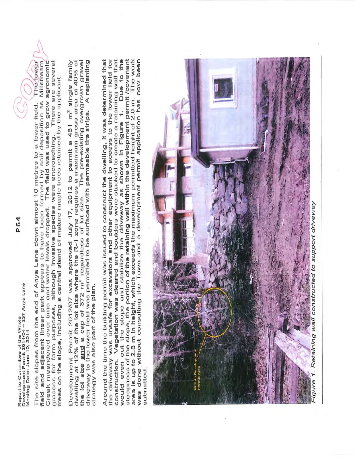
Around the time the building permit was issued to construct the dwelling, it was determined that the driveway was unsafe for excavators and other equipment to access the lower field for construction. Vegetation was cleared and boulders were stacked to create a retaining wall that would even out the slope and stabilize the driveway as shown in Figure 1. Due to the steepness of the slope, the portion of the retaining wall within the development permit /covenant area is up to 2.8 m in height, which exceeds the maximum permitted height of 2.0 m. The work was done without consulting the Town and a development permit application has now been submitted.
PROPOSAL
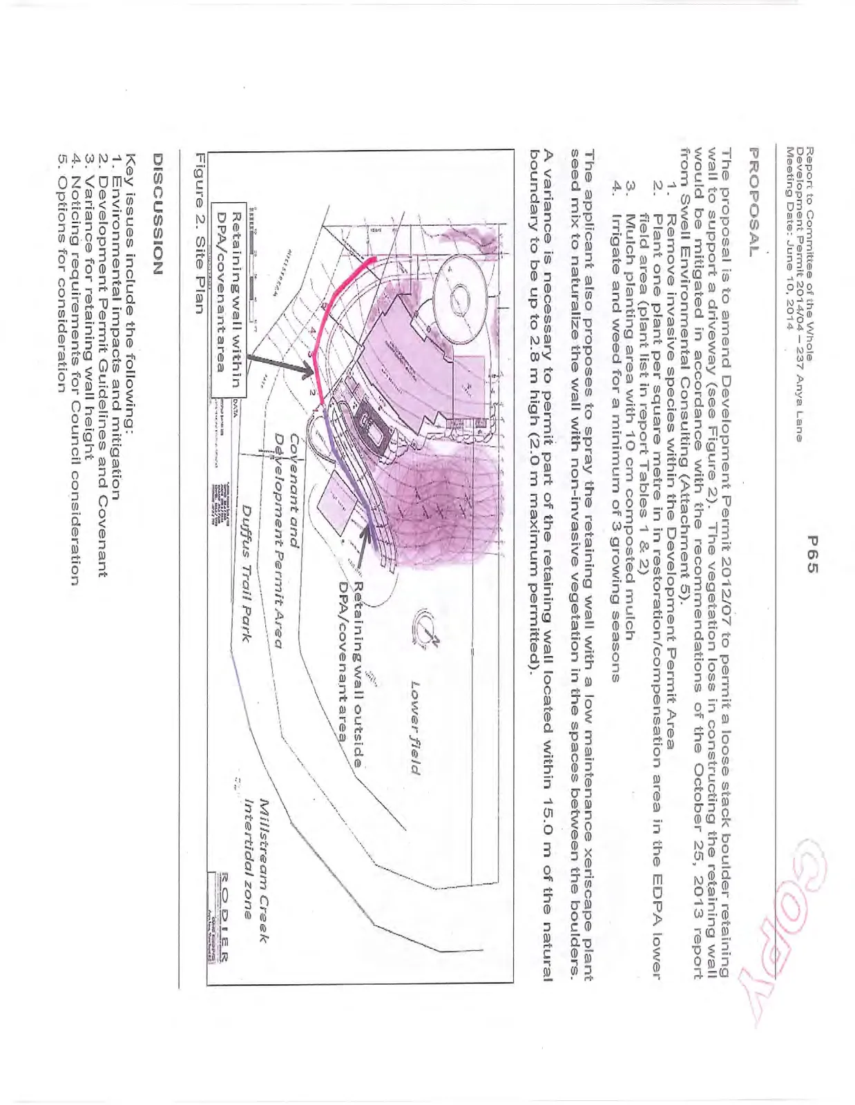
The proposal is to amend Development Permit 2012/07 to permit a loose stack boulder retaining wall to support a driveway (see Figure 2). The vegetation loss in constructing the retaining wall would be mitigated in accordance with the recommendations of the October 25, 2013 report from Swell Environmental Consulting (Attachment 5).
- Remove invasive species within the Development Permit Area
- Plant one plant per square metre in in restoration/compensation area in the EDPA lower field area (plant list in report Tables 1 & 2)
- Mulch planting area with 10 cm composted mulch
- Irrigate and weed for a minimum of 3 growing seasons
The applicant also proposes to spray the retaining wall with a low maintenance xeriscape plant seed mix to naturalize the wall with non-invasive vegetation in the spaces between the boulders.
A variance is necessary to permit part of the retaining wall located within 15.0 m of the natural boundary to be up to 2.8 m high (2.0 m maximum permitted).
DISCUSSION
Key issues include the following:
- Environmental impacts and mitigation
- Development Permit Guidelines and Covenant
- Variance for retaining wall height
- Noticing requirements for Council consideration
- Options for consideration
1. Environmental impacts and mitigation
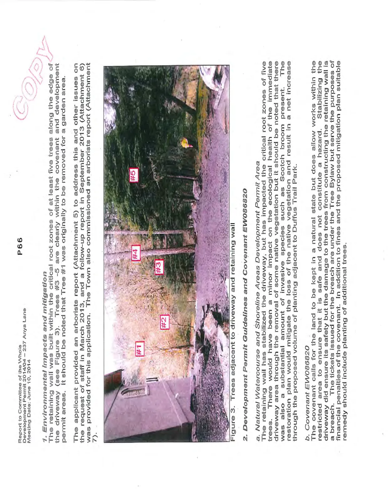
The retaining wall was built within the critical root zones of at least five trees along the edge of the driveway (see Figure 3). Trees #3 -5 are clearly within the covenant and development permit areas. It should be noted that Tree #1 was originally to be removed for a garden area.
The applicant provided an arborists report (Attachment 5) to address this and other issues on the request of staff in March 2013, and a follow-up report in September 2013 (Attachment 6) was provided for this application. The Town also commissioned an arborists report (Attachment 7).
2. Development Permit Guidelines and Covenant EW086820
a. Natural Watercourse and Shoreline Areas Development Permit Area The retaining wall has stabilized the driveway, but has impacted the critical root zones of five trees. There would have been a minor impact on the ecological health of the immediate driveway area through the removal of some native vegetation but it should be noted that there was also a substantial amount of invasive species such as Scotch broom present. The restoration plan would mitigate the loss of the native vegetation and result in a net increase through the proposed volume of planting adjacent to Duffus Trail Park.
b. Covenant EW086820 The covenant calls for the land to be kept in a natural state but does allow works within the restricted area to ensure that it is safe and does not constitute a hazard. Stabilizing the driveway did ensure its safety but the damage to the trees from constructing the retaining wall is a breach. The tickets issued for the breach are under the Tree Bylaw but serve the purposes of financial penalties of the covenant. In addition to fines and the proposed mitigation plan suitable remedy should include planting of additional trees.
3. Variance for Retaining Wall Height
The highest part of the retaining wall within the required building setback is 2.8m Land Use Bylaw 1990, No. 35 permits a maximum height of 2.0 m. There would be no significant visual or other impacts on adjacent residents.
4. Noticing requirements for Council consideration
This application can be considered by Council subject to comments from the Committee of the Whole meeting and notice requirements of the Local Government Act and Development Procedures Bylaw No. 730, 2009.
5. Options for consideration
Options for Council consideration include the following:
Option 1. Approve the application To mitigate the loss of native vegetation in the retaining wall area, the proposal provides for extensive removal of invasive species and the re-introduction of native planting adjacent to Duffus Trail Park. Over time, these enhancements would help to restore part of the natural ecosystem that was stripped by the historic farming use of the field. The remediation plan should also specify the specific size of additional trees to be planted in terms of volume to make up for the expected loss of the damaged trees.
Option 2. Approve the application with conditions Between the damage to the tree roots that help to hold up the slope and the continuing shoreline erosion and undermining caused by Millstream Creek, it may be prudent to require that the applicant commission a geotechnical / hydrological study on the long term stability of the entire bank. This was not required in the original development permit because the development permit area was to be left relatively untouched.
Option 3. Reject the application Without the retaining wall, the driveway would be unusable. It should be noted The arborist report commissioned by the Town (Attachment 7) does not recommend removal of the retaining wall because it would create further damage to the trees. Any potential slope instability would be exacerbated.
RECOMMENDATION
That the June 6, 2014 report from the Senior Planner titled “Environmental Development Permit Application 2014/04 – 237 Anya Lane” be received.
SUBMITTED BY: Jeff Chow, MCIP, RPP Senior Planner
REVIEWED BY: Lindsay Chase, MCIP, RPP Director of Development Services
ATTACHMENTS
- Location plan
- Letter from Applicant – May 6, 2014
- Covenant EW086820 (6 pages)
- Restoration and Compensation Plan – Swell Environmental Consulting – October 25, 2013 (5 pages)
- Tree Impact Review for 237 Anya Lane – Talbot McKenzie & Associates – March 14, 2013 (3 pages)
- Tree Impact Review for 237 Anya Lane – Talbot McKenzie & Associates – September 26, 2013 (2 pages)
- 237 Anya Lane Damage Assessment Report - Michael Gye & Heidi Krogstad Urban Forestry - April 29, 2014 (5 pages – note page 5 is blank)
Document Images
(3)