STAFF REPORT: ENVIRONMENTAL DEVELOPMENT PERMIT APPLICATION 2014/06 – 2427 Chilco Road (Thetis Vale Phase 7)
Report recommending approval for a 36-lot residential subdivision, including road widths variances and environmental protection measures.
TO: Mayor & Council DATE: October 16, 2014 FROM: Jeff Chow, MCIP, RPP, Senior Planner MEETING: October 21, 2014 FILE NOs: 3060-20-2014/06
ENVIRONMENTAL DEVELOPMENT PERMIT APPLICATION 2014/06 - 2427 Chilco Road (Thetis Vale Phase 7)
RECOMMENDATIONS:
- THAT Development Permit 2014/06 be approved;
AND THAT Development Permit 2014/06 include the following conditions:
a. Site work adjacent to the drainage channel to be in accordance with the recommendations of RAR Report 3109 by P.A. Harder Associates including the following: i. The 10 m wide SPEA boundary on both side of the creek channel needs to be clearly marked prior to the start of construction. ii. Temporary snow fencing to be erected along the crest of the gulley slope and maintained throughout the construction period iii. Control and treatment of surface water runoff is required throughout the construction period to ensure that sediment laden waters do no enter the stream channel iv. No equipment is permit within the identified SPEA boundary v. All culvert installation work needs to be scheduled for the June 15 to September 15 period vi. A Section 9 notification to the BC Ministry of Environment is required for all culvert installation work. vii. Tree clearing within the Riparian Assessment area should be planned to minimize tree removal and create a feathered edge along the sides of the ravine when possible. b. Temporary fencing and posting of notices around sensitive features (including all P-3 zoned land) prior to land clearing, site preparation, blasting, grading, servicing and construction. Fences are not to be removed until authorized by the Director of Development Services; c. Arborist to be present during clearing, blasting, excavation, and fill deposit of land within 7.5 metres of the two parks (P-3 zoned areas) to ensure minimum impact on protected root zones of trees to be retained; d. Following blasting, a tree report from a certified arborist to address danger trees and to provide recommendations for mitigation of further construction impacts; e. All development must be certified safe by a geotechnical engineer, with reports to be provided to the Town. f. Geotechnical reports for the two parks (P-3 zoned areas) to be provided to the Town.
g. Site work adjacent to the drainage channel to be in accordance with the recommendations of the May 20, 2014 Interface Fire Hazard/Interface Wildfire Threat Assessment - Strathcona Forestry Consulting - including the following:
Land Clearing i. Land clearing to be conducted in accordance with the BC Wildfire Act. ii. Appropriate firefighting tools and equipment to be on site for high risk land clearing activities between April 1 and October 31. iii. Emergency Plan of Action to be on site with a copy provided to the Town. iv. Hazard abatement in accordance with Town and CRD bylaws. v. Construction workers to be made aware of fire risks.
Vegetation Management vi. Establish and maintain a FireSmart Priority Zone up to 10 m around building footprints on the east side of lots 4-10 and the west side of lots 24-36. vii. Establish and maintain a FireSmart Priority Zone up to 15 m around existing building at Lot 37 and extend vegetation management to 15+ m. viii. Landscaping to incorporate fire-resistant vegetation. ix. Remove invasive species and replant with approved FireSmart landscaping.
Construction x. Class A, B, or C Fire retardant roof assemblies and non-combustible siding on new residences. xi. Follow FireSmart Guidelines for window/door glazing, eaves, vents, decking, and chimneys with approved spark arrestors. xii. Homes and accessory buildings to be equipped with working smoke alarms.
Access xiii. Roads and driveways to meet Canadian Geometric Road Design Guidelines for gradient and overhead clearance. xiv. Street addresses to be clearly evident during construction phase – at least 10 cm high with 12mm stroke, contrasting background colour and reflective. xv. New structures, road, driveways to be mapped for Fire Department xvi. Access road to provide simultaneous access for emergency equipment and evacuation.
Fire Protection xvii. Tanker truck and adequate fire tools for initial attack onsite during April to October.
Regulatory Provisions xviii. Follow-up assessment after subdivision approval to ensure mitigation measures have been implemented.
h. A development variance permit application be considered by Council for road widths, height of retaining walls, and definition of grade prior to subdivision to create Proposed Lots 1-36 as per the plans attached to the October 16, 2014 report from the Senior Planner i. Hours of tree removal, site preparation, blasting, servicing and construction to be in accordance with Noise Control Bylaw, 2003, No. 523; j. Security deposit of $50,000 for potential damage to the natural environment.
THAT an exemption of lot frontage requirements for Proposed Lots 10, 11, 16, 17, 18, 19 and 37 be approved as per the plans attached to the October 16, 2014 report from the Senior Planner.
THAT the proposed subdivision of Lot 37 be permitted to proceed as a separate application.
CHIEF ADMINISTRATIVE OFFICER’S COMMENTS:
I concur with the recommendation.
DIRECTOR OF DEVELOPMENT SERVICES’ COMMENTS:
I concur with the recommendation.
PURPOSE
The purpose of this report is to consider and Environmental Development Permit to permit a 37-lot subdivision and to consider frontage waivers for seven proposed lots.
BACKGROUND
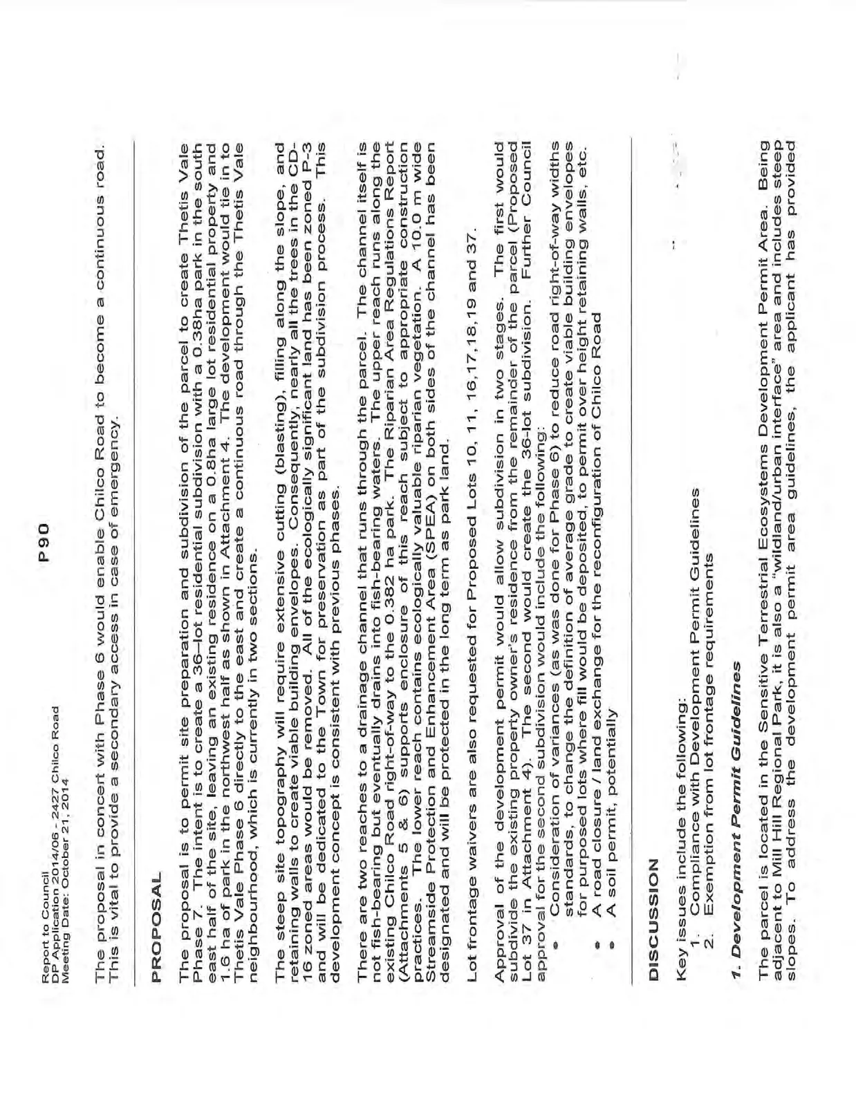
The 4.7 ha parcel is located on the east slope of Mill Hill between Chilco Road and Trans-Canada Highway. There is a single family dwelling and an accessory building on the parcel. Access is from Chilco Road via a long, winding driveway. The remainder of the parcel is forested with some drainage channels running through the site. Chilco Road is blocked with locked bollards at the east end of the site. The parcel was rezoned A-3, CD-16, and P-3 as shown in Figure 1. Staff is working with the applicant and the Ministry of Transportation and Infrastructure to formalize offsite storm water management for this and previous phases.
PROPOSAL
The proposal in concert with Phase 6 would enable Chilco Road to become a continuous road. This is vital to provide a secondary access in case of emergency.
The proposal is to permit site preparation and subdivision of the parcel to create Thetis Vale Phase 7. The intent is to create a 36-lot residential subdivision with a 0.38ha park in the south east half of the site, leaving an existing residence on a 0.8ha large lot residential property and 1.6 ha of park in the northwest half as shown in Attachment 4. The development would tie in to Thetis Vale Phase 6 directly to the east and create a continuous road through the Thetis Vale neighbourhood, which is currently in two sections.
The steep site topography will require extensive cutting (blasting), filling along the slope, and retaining walls to create viable building envelopes. Consequently, nearly all the trees in the CD-16 zoned areas would be removed. All of the ecologically significant land has been zoned P-3 and will be dedicated to the Town for preservation as part of the subdivision process. This development concept is consistent with previous phases.
There are two reaches to a drainage channel that runs through the parcel. The channel itself is not fish-bearing but eventually drains into fish-bearing waters. The upper reach runs along the existing Chilco Road right-of-way to the 0.382 ha park. The Riparian Area Regulations Report (Attachments 5 & 6) supports enclosure of this reach subject to appropriate construction practices. The lower reach contains ecologically valuable riparian vegetation. A 10.0 m wide Streamside Protection and Enhancement Area (SPEA) on both sides of the channel has been designated and will be protected in the long term as park land.
Lot frontage waivers are also requested for Proposed Lots 10, 11, 16, 17, 18, 19 and 37.
Approval of the development permit would allow subdivision in two stages. The first would subdivide the existing property owner’s residence from the remainder of the parcel (Proposed Lot 37 in Attachment 4). The second would create the 36-lot subdivision. Further Council approval for the second subdivision would include the following:
- Consideration of variances (as was done for Phase 6) to reduce road right-of-way widths standards, to change the definition of average grade to create viable building envelopes for purposed lots where fill would be deposited, to permit over height retaining walls, etc.
- A road closure / land exchange for the reconfiguration of Chilco Road
- A soil permit, potentially
DISCUSSION
Key issues include the following:
- Compliance with Development Permit Guidelines
- Exemption from lot frontage requirements
1. Development Permit Guidelines
The parcel is located in the Sensitive Terrestrial Ecosystems Development Permit Area. Being adjacent to Mill Hill Regional Park, it is also a "wildland/urban interface" area and includes steep slopes. To address the development permit area guidelines, the applicant has provided professional reports on Riparian Areas Assessment, slope stability, storm water management and Interface Fire hazard/Interface Wildfire Threat Assessment (Attachments 5-9).
An analysis of the guidelines is summarized in Attachment 11. The proposal generally complies with the intent of the guidelines. The aspects that do not comply can be justified through the dedication of 40% of the site. A number of conditions are recommend to ensure that the guidelines are address. These are listed in the recommendations and relate to protection of the riparian area, tree preservation, managing steep slope hazards and fire protection,
2. Exemption from Lot Frontage Requirements
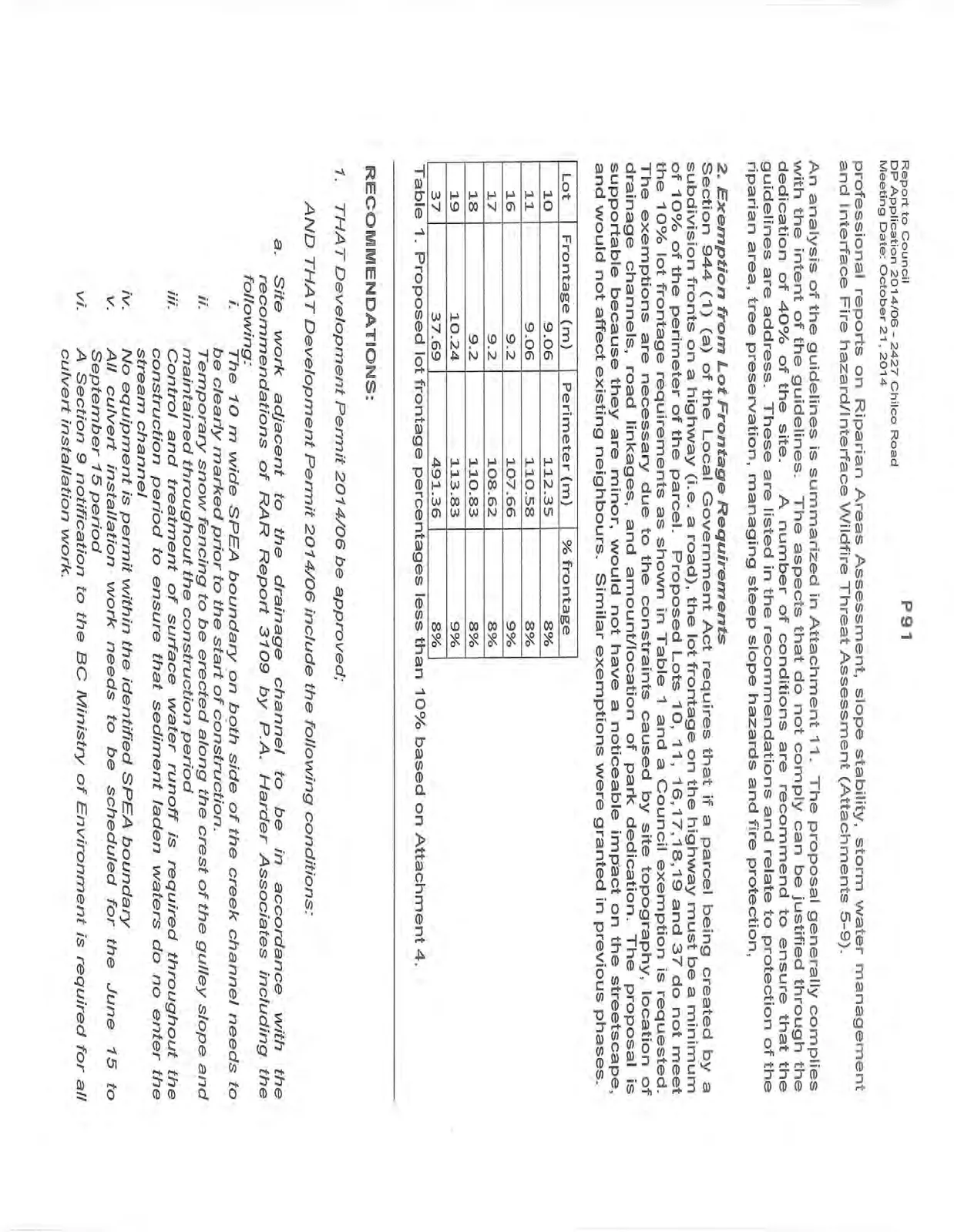
Section 944 (1) (a) of the Local Government Act requires that if a parcel being created by a subdivision fronts on a highway (i.e. a road), the lot frontage on the highway must be a minimum of 10% of the perimeter of the parcel. Proposed Lots 10, 11, 16, 17, 18, 19 and 37 do not meet the 10% lot frontage requirements as shown in Table 1 and a Council exemption is requested. The exemptions are necessary due to the constraints caused by site topography, location of drainage channels, road linkages, and amount/location of park dedication. The proposal is supportable because they are minor, would not have a noticeable impact on the streetscape, and would not affect existing neighbours. Similar exemptions were granted in previous phases.
Table 1. Proposed lot frontage percentages less than 10% based on Attachment 4.
| Lot | Frontage (m) | Perimeter (m) | % frontage |
|---|---|---|---|
| 10 | 9.06 | 112.35 | 8% |
| 11 | 9.06 | 110.58 | 8% |
| 16 | 9.2 | 107.66 | 9% |
| 17 | 9.2 | 108.62 | 8% |
| 18 | 9.2 | 110.83 | 8% |
| 19 | 10.24 | 113.83 | 9% |
| 37 | 37.69 | 491.36 | 8% |
RECOMMENDATIONS:
- THAT Development Permit 2014/06 be approved;
AND THAT Development Permit 2014/06 include the following conditions:
a. Site work adjacent to the drainage channel to be in accordance with the recommendations of RAR Report 3109 by P.A. Harder Associates including the following: i. The 10 m wide SPEA boundary on both side of the creek channel needs to be clearly marked prior to the start of construction. ii. Temporary snow fencing to be erected along the crest of the gulley slope and maintained throughout the construction period iii. Control and treatment of surface water runoff is required throughout the construction period to ensure that sediment laden waters do no enter the stream channel iv. No equipment is permit within the identified SPEA boundary v. All culvert installation work needs to be scheduled for the June 15 to September 15 period vi. A Section 9 notification to the BC Ministry of Environment is required for all culvert installation work.
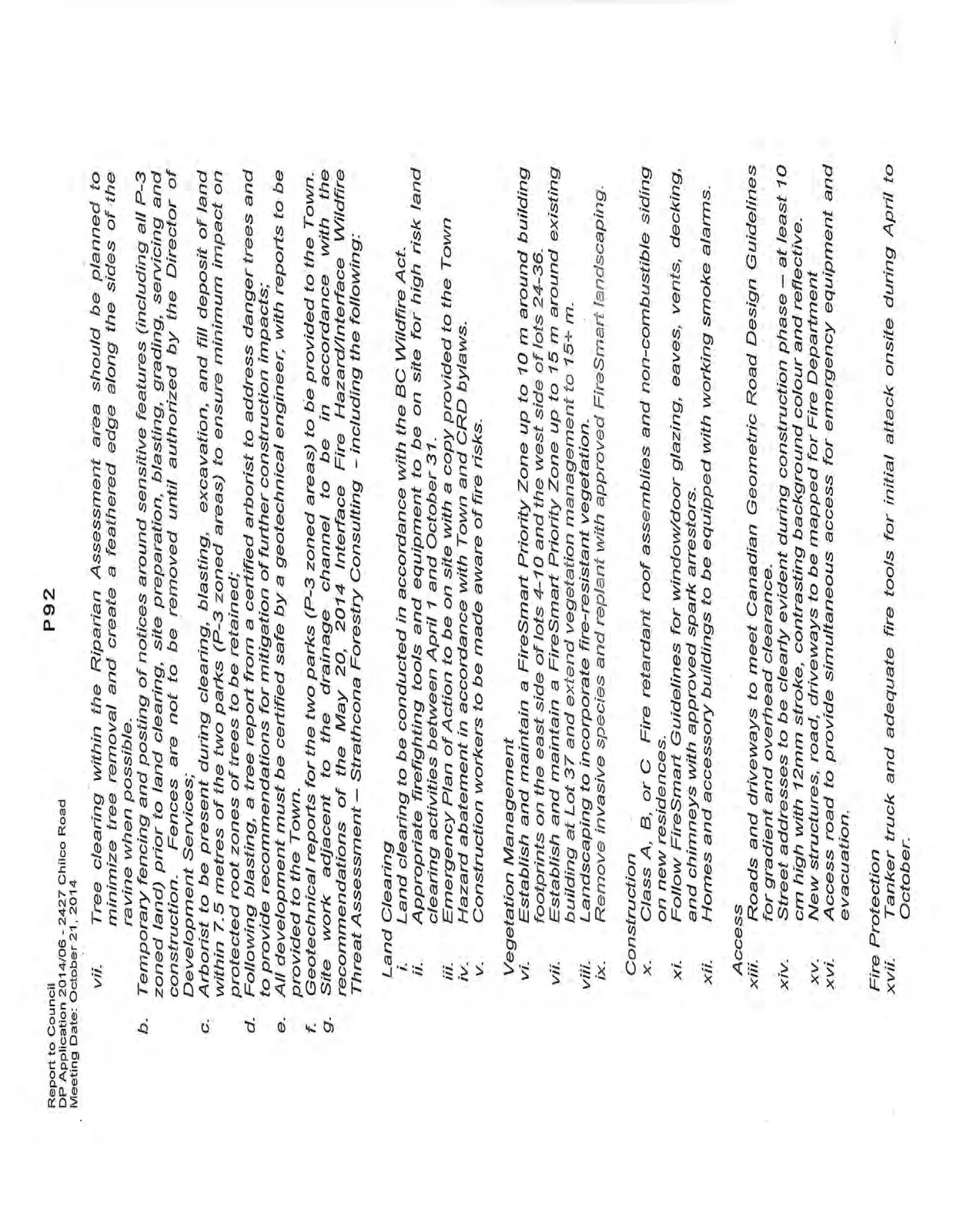
vii. Tree clearing within the Riparian Assessment area should be planned to minimize tree removal and create a feathered edge along the sides of the ravine when possible. b. Temporary fencing and posting of notices around sensitive features (including all P-3 zoned land) prior to land clearing, site preparation, blasting, grading, servicing and construction. Fences are not to be removed until authorized by the Director of Development Services; c. Arborist to be present during clearing, blasting, excavation, and fill deposit of land within 7.5 metres of the two parks (P-3 zoned areas) to ensure minimum impact on protected root zones of trees to be retained; d. Following blasting, a tree report from a certified arborist to address danger trees and to provide recommendations for mitigation of further construction impacts; e. All development must be certified safe by a geotechnical engineer, with reports to be provided to the Town. f. Geotechnical reports for the two parks (P-3 zoned areas) to be provided to the Town. g. Site work adjacent to the drainage channel to be in accordance with the recommendations of the May 20, 2014 Interface Fire Hazard/Interface Wildfire Threat Assessment – Strathcona Forestry Consulting – including the following:
Land Clearing i. Land clearing to be conducted in accordance with the BC Wildfire Act. ii. Appropriate firefighting tools and equipment to be on site for high risk land clearing activities between April 1 and October 31. iii. Emergency Plan of Action to be on site with a copy provided to the Town. iv. Hazard abatement in accordance with Town and CRD bylaws. v. Construction workers to be made aware of fire risks.
Vegetation Management vi. Establish and maintain a FireSmart Priority Zone up to 10 m around building footprints on the east side of lots 4-10 and the west side of lots 24-36. vii. Establish and maintain a FireSmart Priority Zone up to 15 m around existing building at Lot 37 and extend vegetation management to 15+ m. viii. Landscaping to incorporate fire-resistant vegetation. ix. Remove invasive species and replant with approved FireSmart landscaping.
Construction x. Class A, B, or C Fire retardant roof assemblies and non-combustible siding on new residences. xi. Follow FireSmart Guidelines for window/door glazing, eaves, vents, decking, and chimneys with approved spark arrestors. xii. Homes and accessory buildings to be equipped with working smoke alarms.
Access xiii. Roads and driveways to meet Canadian Geometric Road Design Guidelines for gradient and overhead clearance. xiv. Street addresses to be clearly evident during construction phase – at least 10 cm high with 12mm stroke, contrasting background colour and reflective. xv. New structures, road, driveways to be mapped for Fire Department xvi. Access road to provide simultaneous access for emergency equipment and evacuation.
Fire Protection xvii. Tanker truck and adequate fire tools for initial attack onsite during April to October.
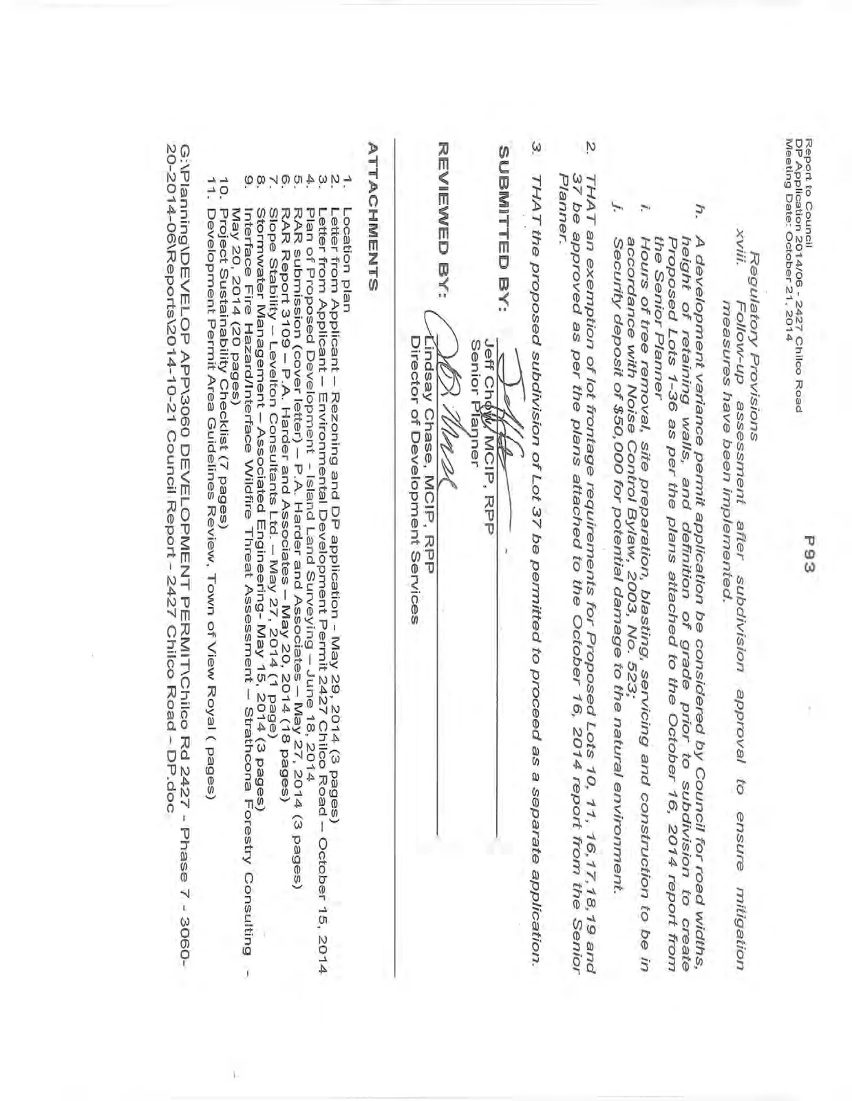
Regulatory Provisions xviii. Follow-up assessment after subdivision approval to ensure mitigation measures have been implemented.
h. A development variance permit application be considered by Council for road widths, height of retaining walls, and definition of grade prior to subdivision to create Proposed Lots 1-36 as per the plans attached to the October 16, 2014 report from the Senior Planner i. Hours of tree removal, site preparation, blasting, servicing and construction to be in accordance with Noise Control Bylaw, 2003, No. 523; j. Security deposit of $50,000 for potential damage to the natural environment.
THAT an exemption of lot frontage requirements for Proposed Lots 10, 11, 16, 17, 18, 19 and 37 be approved as per the plans attached to the October 16, 2014 report from the Senior Planner.
THAT the proposed subdivision of Lot 37 be permitted to proceed as a separate application.
ATTACHMENTS
- Location plan
- Letter from Applicant – Rezoning and DP application – May 29, 2014 (3 pages)
- Letter from Applicant – Environmental Development Permit 2427 Chilco Road – October 15, 2014
- Plan of Proposed Development – Island Land Surveying – June 18, 2014
- RAR submission (cover letter) – P.A. Harder and Associates – May 27, 2014 (3 pages)
- RAR Report 3109 – P.A. Harder and Associates – May 20, 2014 (18 pages)
- Slope Stability – Levelton Consultants Ltd. – May 27, 2014 (1 page)
- Stormwater Management – Associated Engineering– May 15, 2014 (3 pages)
- Interface Fire Hazard/Interface Wildfire Threat Assessment – Strathcona Forestry Consulting – May 20, 2014 (20 pages)
- Project Sustainability Checklist (7 pages)
- Development Permit Area Guidelines Review, Town of View Royal (pages)
G:\Planning\DEVELOP APP\3060 DEVELOPMENT PERMIT\Chilco Rd 2427 - Phase 7 - 3060-20-2014-06\Reports\2014-10-21 Council Report - 2427 Chilco Road - DP.doc