Interface Fire Hazard / Interface Wildfire Threat Assessment - Strathcona Forestry Consulting
Comprehensive wildfire threat assessment for the proposed subdivision with recommendations for FireSmart management.
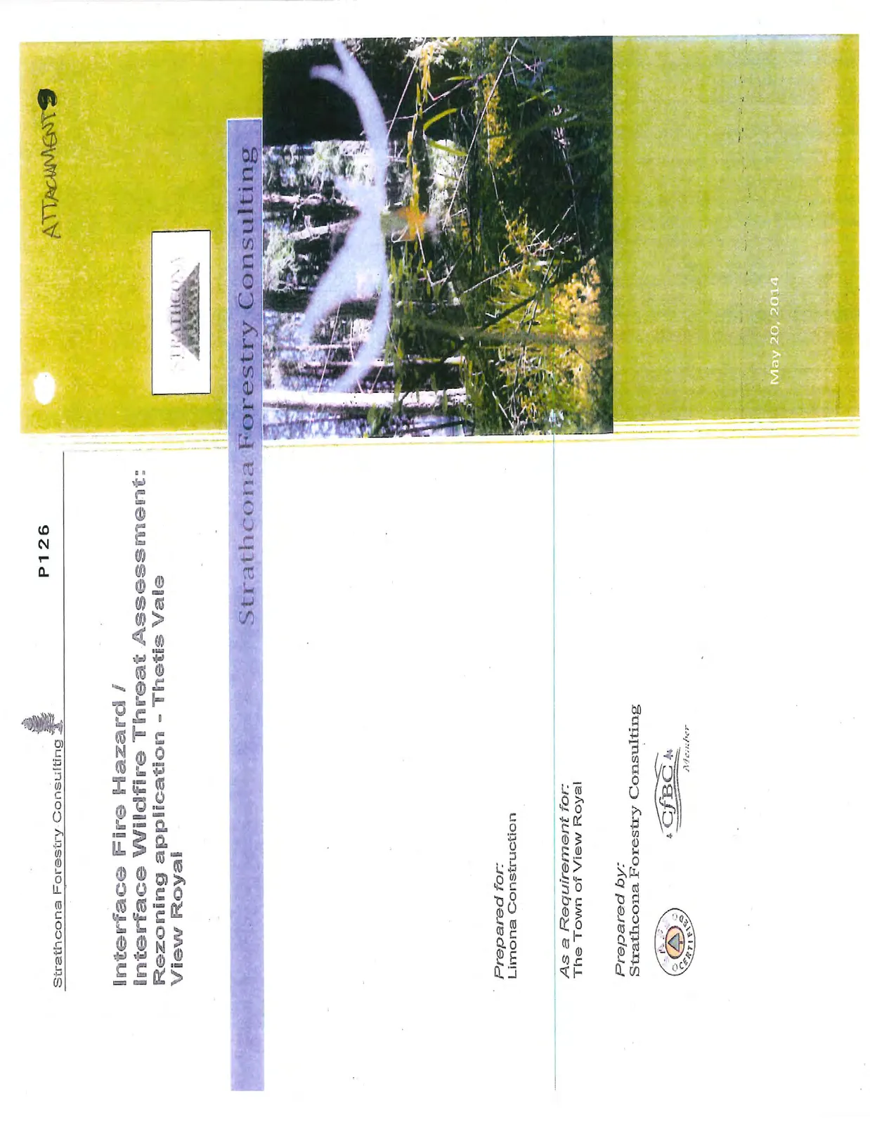
Interface Fire Hazard / Interface Wildfire Threat Assessment: Rezoning application - Thetis Vale View Royal
Prepared for: Limona Construction
As a Requirement for: The Town of View Royal
Prepared by: Strathcona Forestry Consulting
May 20, 2014
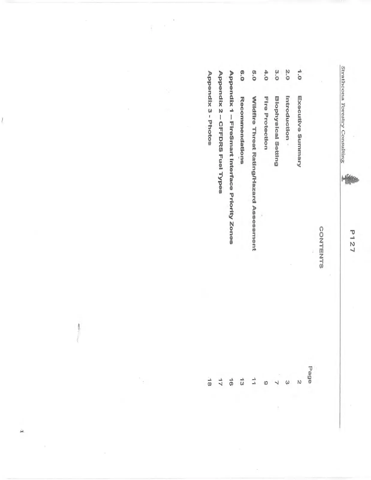
CONTENTS
| Section | Title | Page |
|---|---|---|
| 1.0 | Executive Summary | 2 |
| 2.0 | Introduction | 3 |
| 3.0 | Biophysical Setting | 7 |
| 4.0 | Fire Protection | 9 |
| 5.0 | Wildfire Threat Rating/Hazard Assessment | 11 |
| 6.0 | Recommendations | 13 |
| Appendix 1 | FireSmart Interface Priority Zones | 16 |
| Appendix 2 | CFFDRS Fuel Types | 17 |
| Appendix 3 | Photos | 18 |
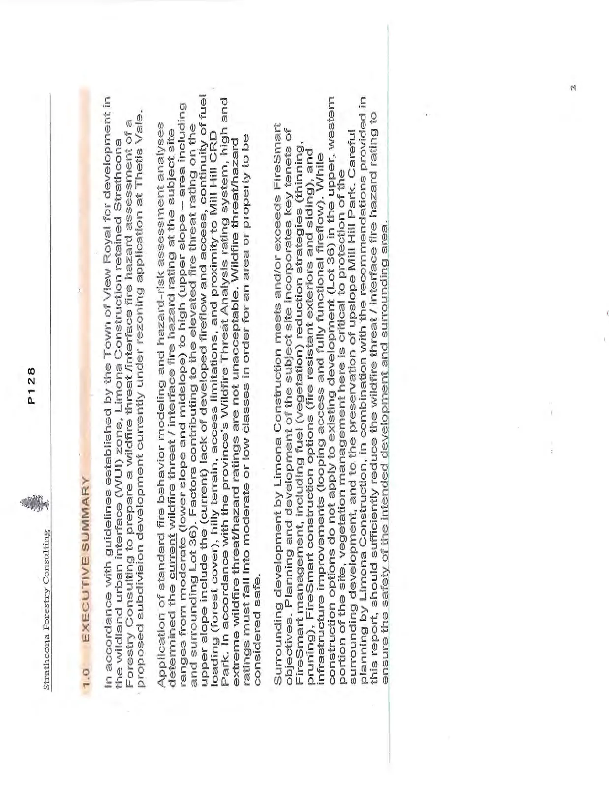
1.0 EXECUTIVE SUMMARY
In accordance with guidelines established by the Town of View Royal for development in the wildland urban interface (WUI) zone, Limona Construction retained Strathcona Forestry Consulting to prepare a wildfire threat /interface fire hazard assessment of a proposed subdivision development currently under rezoning application at Thetis Vale.
Application of standard fire behavior modeling and hazard-risk assessment analyses determined the current wildfire threat / interface fire hazard rating at the subject site ranges from moderate (lower slope and midslope) to high (upper slope – area including and surrounding Lot 36). Factors contributing to the elevated fire threat rating on the upper slope include the (current) lack of developed fireflow and access, continuity of fuel loading (forest cover), hilly terrain, access limitations, and proximity to Mill Hill CRD Park. In accordance with the province's Wildfire Threat Analysis rating system, high and extreme wildfire threat/hazard ratings are not unacceptable. Wildfire threat/hazard ratings must fall into moderate or low classes in order for an area or property to be considered safe.
Surrounding development by Limona Construction meets and/or exceeds FireSmart objectives. Planning and development of the subject site incorporates key tenets of FireSmart management, including fuel (vegetation) reduction strategies (thinning, pruning), FireSmart construction options (fire resistant exteriors and siding), and infrastructure improvements (looping access and fully functional fireflow). While construction options do not apply to existing development (Lot 36) in the upper, western portion of the site, vegetation management here is critical to protection of the surrounding development, and to the preservation of upslope Mill Hill Park. Careful planning by Limona Construction, in combination with the recommendations provided in this report, should sufficiently reduce the wildfire threat / interface fire hazard rating to ensure the safety of the intended development and surrounding area.
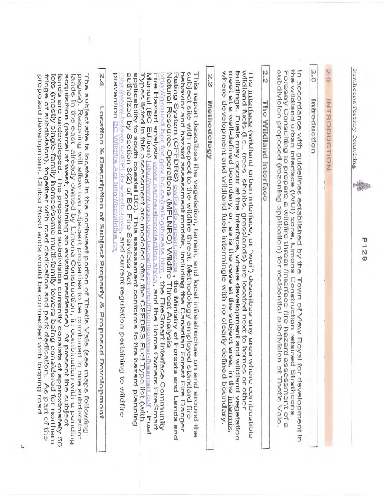
2.0 INTRODUCTION
2.0 Introduction
In accordance with guidelines established by the Town of View Royal for development in the wildland urban interface (WUI) zone, Limona Construction retained Strathcona Forestry Consulting to prepare a wildfire threat /interface fire hazard assessment of a subdivision proposed (rezoning application) for residential subdivision at Thetis Vale.
2.2 The Wildland Interface
The interface (wildland urban interface, or "wui") describes any area where combustible wildland fuels (i.e., trees, shrubs, grasslands) are located next to homes or other buildings. Fuels may occur at the interface, where development and wildland vegetation meet at a well-defined boundary, or, as is the case at the subject area, in the intermix, where development and wildland fuels intermingle with no clearly defined boundary.
2.3 Methodology
This report describes the vegetation, terrain, and local infrastructure on and around the subject site with respect to the wildfire threat. Methodology employed standard fire behavior and hazard assessment models, including the Canadian Forest Fire Danger Rating System (CFFDRS) cwfis.cfs.nrcan.gc.ca, the Ministry of Forests and Lands and Natural Resource Operations (MFLNRO) Wildfire Threat Analysis http://ground.hpr.for.gov.bc.ca/ratingthreats.htm, the FireSmart Interface Community Fire Hazard analysis www.partnersinprotection.ab.ca, and the Home Owners FireSmart Manual (BC Edition) http://www.pssg.gov.bc.ca/firecom/pdf/homeowner-firesmart.pdf. Fuel Types listed in this assessment are modeled after the CFFDRS Fuel Type list (with applicability to south coastal BC). This assessment conforms to fire hazard planning authorized by Section 3(2) of BC Fire Services Act http://www.bclaws.ca/EPLibraries/bclaws, and current regulation pertaining to wildfire prevention BC Wildfire Act http://bcwildfire.ca.
2.4 Location & Description of Subject Property & Proposed Development
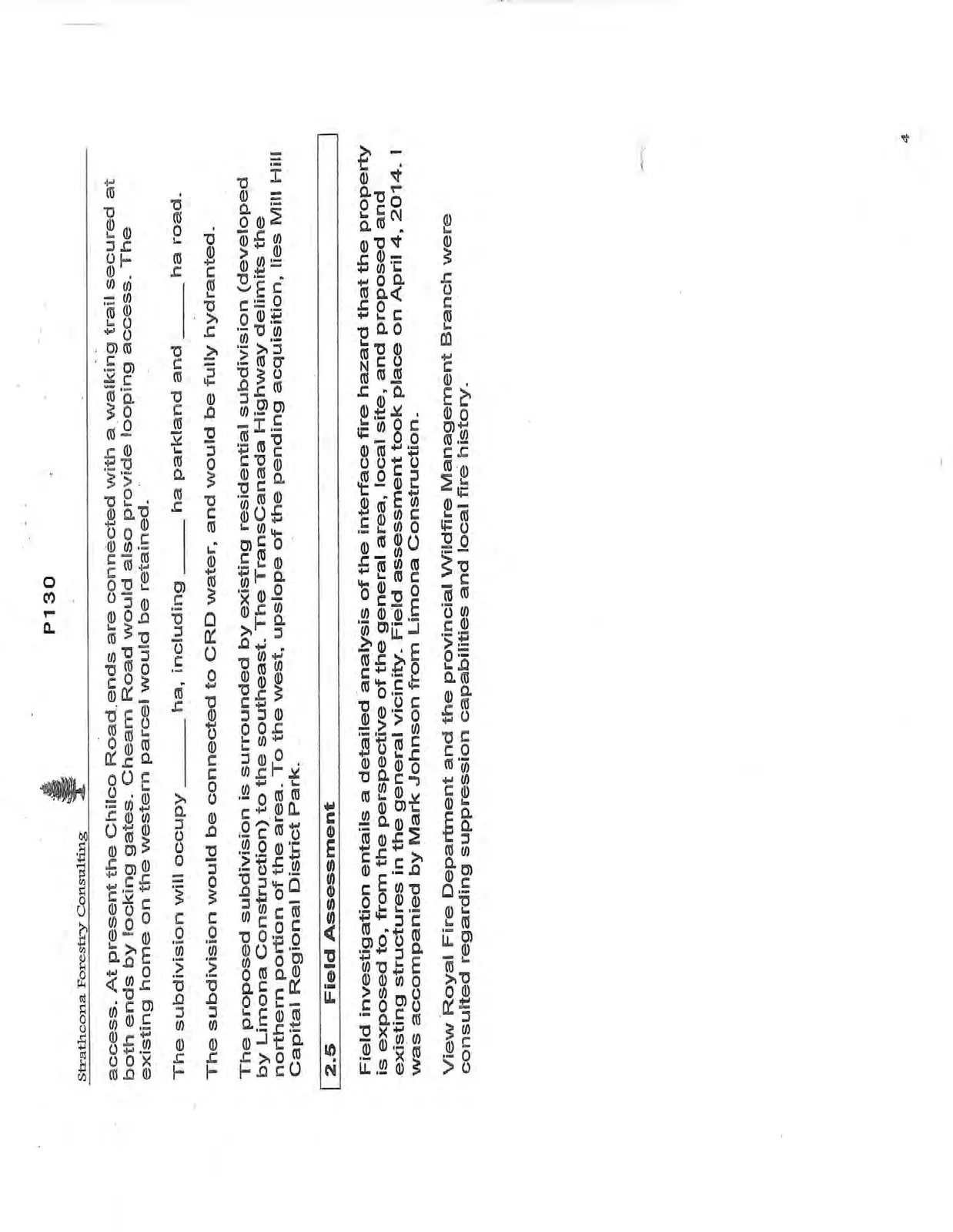
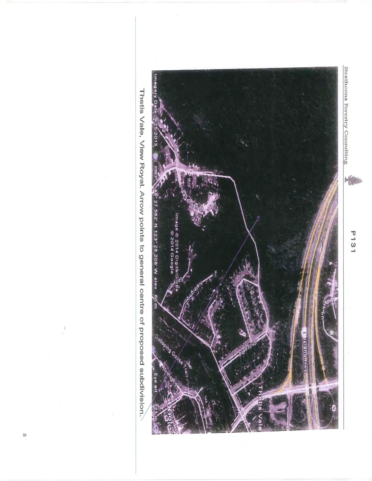
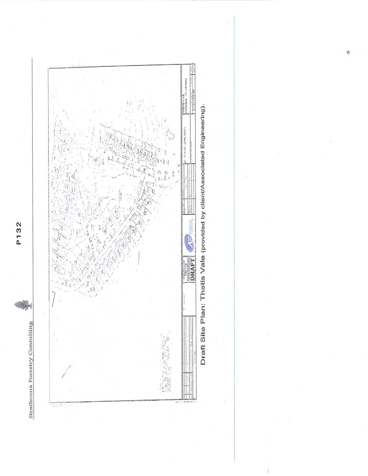
The subject site is located in the northwest portion of Thetis Vale (see maps following pages). Rezoning will allow two adjacent properties to be combined in one subdivision: lands in the east already owned by Limona Construction, in combination with a pending acquisition (parcel at west, containing an existing residence). At present the subject lands are undeveloped. The proposed subdivision currently consists of approximately 56 lots (mostly single-family homes/some multi-family towers being considered for northern fringe of subdivision), together with road dedication and park dedication. As part of the proposed development, Chilco Road ends would be connected with looping road access. At present the Chilco Road ends are connected with a walking trail secured at both ends by locking gates. Cheam Road would also provide looping access. The existing home on the western parcel would be retained.
The subdivision will occupy ____ ha, including ____ ha parkland and ____ ha road.
The subdivision would be connected to CRD water, and would be fully hydranted.
The proposed subdivision is surrounded by existing residential subdivision (developed by Limona Construction) to the southeast. The TransCanada Highway delimits the northern portion of the area. To the west, upslope of the pending acquisition, lies Mill Hill Capital Regional District Park.
2.5 Field Assessment
Field investigation entails a detailed analysis of the interface fire hazard that the property is exposed to, from the perspective of the general area, local site, and proposed and existing structures in the general vicinity. Field assessment took place on April 4, 2014. I was accompanied by Mark Johnson from Limona Construction.
View Royal Fire Department and the provincial Wildfire Management Branch were consulted regarding suppression capabilities and local fire history.
3.0 BIOPHYSICAL DESCRIPTION
3.1 Biogeoclimatic Classification
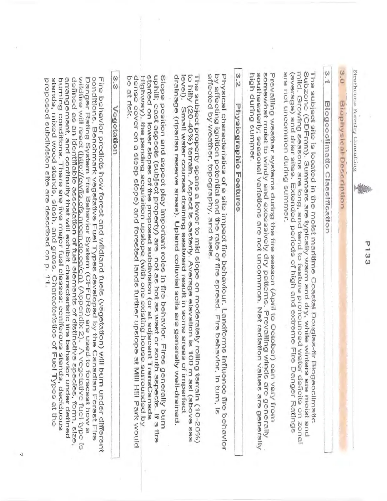
The subject site is located in the moist maritime Coastal Douglas-fir Biogeoclimatic Subzone (CDFmm). Summers are typically warm and dry, while winters are moist and mild. Growing seasons are long, and tend to feature pronounced water deficits on zonal (average) and drier sites. Extended periods of high and extreme Fire Danger Ratings are not uncommon during summer.
Prevailing weather systems during the fire season (April to October) can vary from somewhat moist to windy and excessively dry patterns. Prevailing winds are generally southeasterly; seasonal variations are not uncommon. Net radiation values are generally high during summer.
3.2 Physiographic Features
Physical characteristics of a site impact fire behaviour. Landforms influence fire behavior by affecting ignition potential and the rate of fire spread. Fire behavior, in turn, is affected by weather, topography, and fuels.
The subject property spans a lower to mid slope on moderately rolling terrain (10-20%) to hilly (20-40%) terrain. Aspect is easterly. Average elevation is 100 m asl (above sea level). Small water courses draining eastward result in some areas of imperfect drainage (riparian reserve areas). Upland colluvial soils are generally well-drained.
Slope position and aspect play important roles in fire behavior. Fires generally burn uphill; east aspects (subject property) are not as hot as west or south aspects. If a fire started on lower slopes of the proposed subdivision (or at adjacent TransCanada Highway), the pending acquisition upslope (with one existing house surrounded by dense cover on a steep slope) and forested lands further upslope at Mill Hill Park would be at risk.
3.3 Vegetation
Fire behavior predicts how forest and wildland fuels (vegetation) will burn under different conditions. Benchmark vegetative Fuel Types developed by the Canadian Forest Fire Danger Rating System Fire Behavior System (CFFDRS) are used to forecast how a wildfire will react (http://cwfis.cfs.nrcan.gc.ca/en) (Appendix 2). A vegetative fuel type is defined as an identifiable association of fuel elements of distinctive species, form, size, arrangement, and continuity that will exhibit characteristic fire behavior under defined burning conditions. There are five major fuel classes: coniferous stands, deciduous stands, mixed wood stands, slash, and grass. Characteristics of Fuel Types at the proposed subdivision site are described on p. 11.
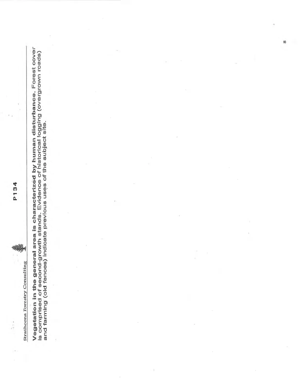
Vegetation in the general area is characterized by human disturbance. Forest cover is comprised of second-growth stands. Evidence of historical logging (overgrown roads) and farming (old fences) indicate previous uses of the subject site.
4.0 FIRE PROTECTION AND INFRASTRUCTURE
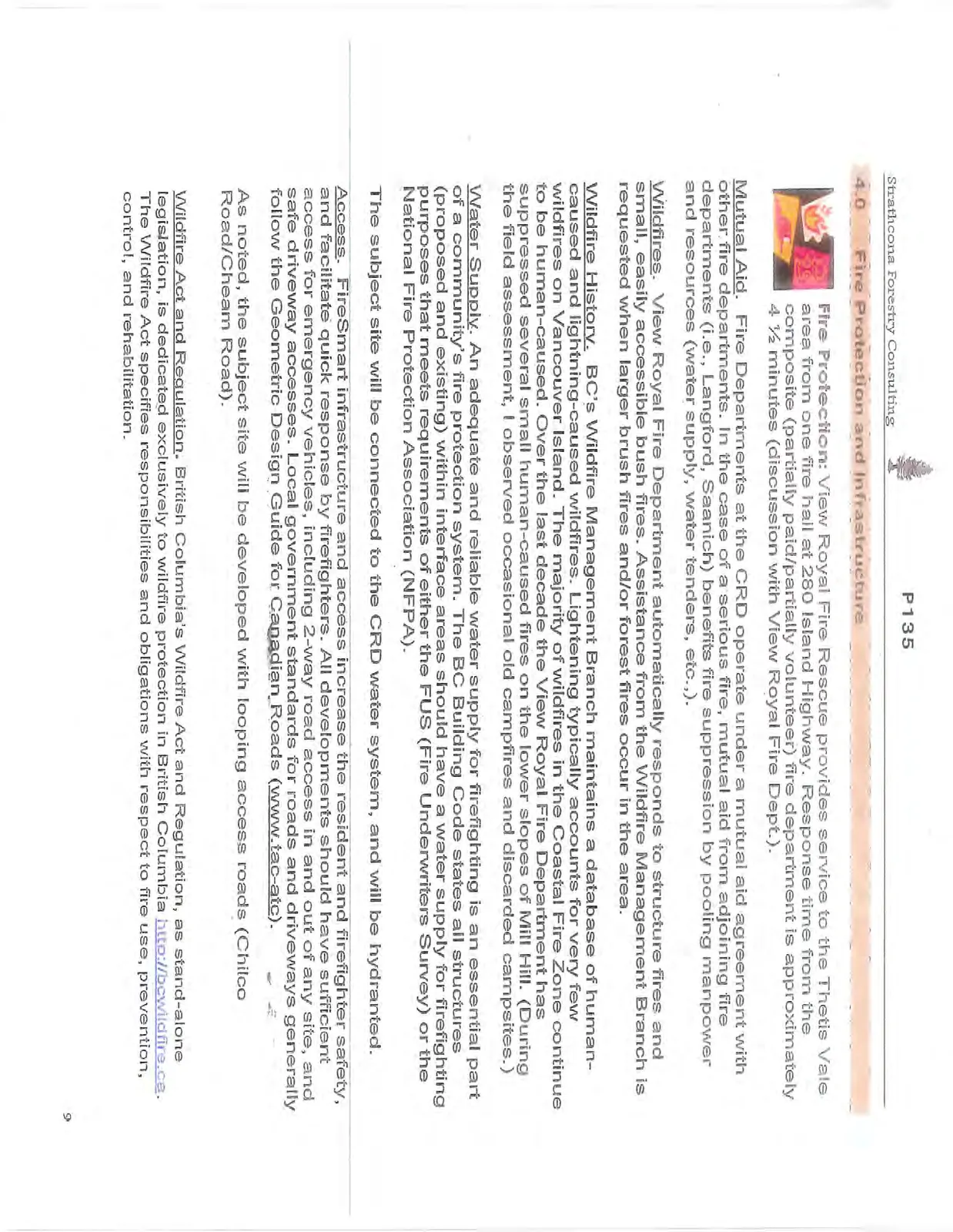
Fire Protection: View Royal Fire Rescue provides service to the Thetis Vale area from one fire hall at 280 Island Highway. Response time from the composite (partially paid/partially volunteer) fire department is approximately 4 ½ minutes (discussion with View Royal Fire Dept.).
Mutual Aid: Fire Departments at the CRD operate under a mutual aid agreement with other fire departments. In the case of a serious fire, mutual aid from adjoining fire departments (i.e., Langford, Saanich) benefits fire suppression by pooling manpower and resources (water supply, water tenders, etc.,).
Wildfires: View Royal Fire Department automatically responds to structure fires and small, easily accessible bush fires. Assistance from the Wildfire Management Branch is requested when larger brush fires and/or forest fires occur in the area.
Wildfire History: BC's Wildfire Management Branch maintains a database of human-caused and lightning-caused wildfires. Lightning typically accounts for very few wildfires on Vancouver Island. The majority of wildfires in the Coastal Fire Zone continue to be human-caused. Over the last decade the View Royal Fire Department has suppressed several small human-caused fires on the lower slopes of Mill Hill. (During the field assessment, I observed occasional old campfires and discarded campsites.)
Water Supply: An adequate and reliable water supply for firefighting is an essential part of a community's fire protection system. The BC Building Code states all structures (proposed and existing) within interface areas should have a water supply for firefighting purposes that meets requirements of either the FUS (Fire Underwriters Survey) or the National Fire Protection Association (NFPA).
The subject site will be connected to the CRD water system, and will be hydranted.
Access: FireSmart infrastructure and access increase the resident and firefighter safety, and facilitate quick response by firefighters. All developments should have sufficient access for emergency vehicles, including 2-way road access in and out of any site, and safe driveway accesses. Local government standards for roads and driveways generally follow the Geometric Design Guide for Canadian Roads (www.tac-atc).
As noted, the subject site will be developed with looping access roads (Chilco Road/Cheam Road).
Wildfire Act and Regulation: British Columbia's Wildfire Act and Regulation, as stand-alone legislation, is dedicated exclusively to wildfire protection in British Columbia http://bcwildfire.ca. The Wildfire Act specifies responsibilities and obligations with respect to fire use, prevention, control, and rehabilitation.
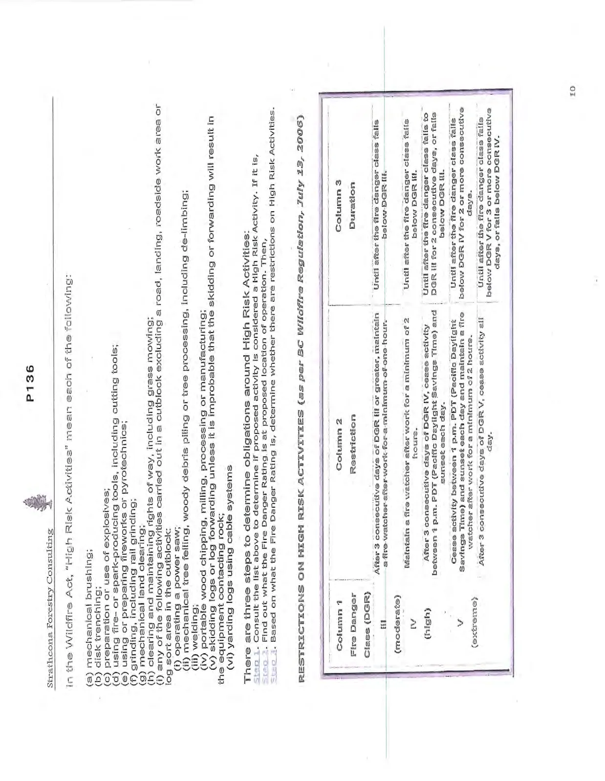
In the Wildfire Act, "High Risk Activities" mean each of the following:
(a) mechanical brushing; (b) disk trenching; (c) preparation or use of explosives; (d) using fire- or spark-producing tools, including cutting tools; (e) using or preparing fireworks or pyrotechnics; (f) grinding, including rail grinding; (g) mechanical land clearing; (h) clearing and maintaining rights of way, including grass mowing; (i) any of the following activities carried out in a cutblock excluding a road, landing, roadside work area or log sort area in the cutblock: (i) operating a power saw; (ii) mechanical tree felling, woody debris piling or tree processing, including de-limbing; (iii) welding; (iv) portable wood chipping, milling, processing or manufacturing; (v) skidding logs or log forwarding unless it is improbable that the skidding or forwarding will result in the equipment contacting rock; (vi) yarding logs using cable systems
There are three steps to determine obligations around High Risk Activities: Step 1. Consult the list above to determine if proposed activity is considered a High Risk Activity. If it is, Step 2. Find out what the Fire Danger Rating is at proposed location of operation. Then, Step 3. Based on what the Fire Danger Rating is, determine whether there are restrictions on High Risk Activities.
RESTRICTIONS ON HIGH RISK ACTIVITIES (as per BC Wildfire Regulation, July 13, 2006)
| Column 1 Fire Danger Class (DGR) | Column 2 Restriction | Column 3 Duration |
|---|---|---|
| III (moderate) | After 3 consecutive days of DGR III or greater, maintain a fire watcher after work for a minimum of one hour. | Until after the fire danger class falls below DGR III. |
| IV (high) | Maintain a fire watcher after work for a minimum of 2 hours. | Until after the fire danger class falls below DGR III. |
| After 3 consecutive days of DGR IV, cease activity between 1 p.m. PDT (Pacific Daylight Savings Time) and sunset each day. | Until after the fire danger class falls to DGR III for 2 consecutive days, or falls below DGR III. | |
| V (extreme) | Cease activity between 1 p.m. PDT (Pacific Daylight Savings Time) and sunset each day and maintain a fire watcher after work for a minimum of 2 hours. | Until after the fire danger class falls below DGR IV for 2 or more consecutive days. |
| After 3 consecutive days of DGR V, cease activity all day. | Until after the fire danger class falls below DGR V for 3 or more consecutive days, or falls below DGR IV. |
5.0 WILDFIRE THREAT / INTERFACE FIRE HAZARD ASSESSMENT
Assessment Results
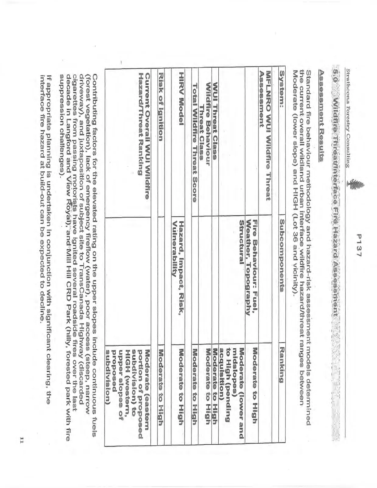
Standard fire behaviour methodology and hazard-risk assessment models determined the current overall wildland urban interface wildfire hazard/threat ranges between Moderate (lower slope) and HIGH (Lot 36 and vicinity).
| System | Subcomponents | Ranking |
|---|---|---|
| MFLNRO WUI Wildfire Threat Assessment | ||
| Fire Behaviour: Fuel, Weather, Topography | Moderate to High | |
| Structural | Moderate (lower and midslopes) to High (pending acquisition) | |
| WUI Threat Class | Moderate to High | |
| Wildfire Behaviour Threat Class | Moderate to High | |
| Total Wildfire Threat Score | Moderate to High | |
| HIRV Model | Hazard, Impact, Risk, Vulnerability | Moderate to High |
| Risk of Ignition | Moderate to High | |
| Current Overall WUI Wildfire Hazard/Threat Ranking | Moderate (eastern portion of proposed subdivision) to HIGH (western, upper slopes of proposed subdivision) |
Contributing factors for the elevated rating on the upper slopes include continuous fuels (forest vegetation), lack of emergency fireflow (water), poor access (steep, narrow driveway), and juxtaposition of subject site to TransCanada Highway (discarded cigarettes from passing motorists have ignited several roadside fires over the last decade in Langford and View Royal), and Mill Hill CRD Park (hilly, forested park with fire suppression challenges).
If appropriate planning is undertaken in conjunction with significant clearing, the interface fire hazard at build-out can be expected to decline.
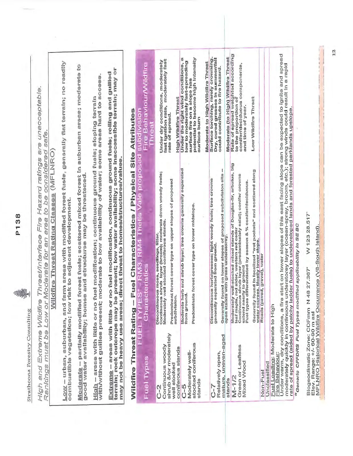
High and Extreme Wildfire Threat/Interface Fire Hazard ratings are unacceptable. Rankings must be Low or Moderate for an area to be considered safe.
Wildfire Threat Rating Classes (MFLNRO)
Low – urban, suburban, and farm areas with modified forest fuels, generally flat terrain; no readily combustible vegetation; low risk to adjacent development.
Moderate – partially modified forest fuels; scattered mixed forest in suburban areas; moderate to good water availability; homes and structures may be threatened.
High – areas with little or no fuel modification; continuous ground fuels; sloping terrain with/without gullies present; moderate to low availability of water; some areas hard to access.
Extreme – areas with little or no fuel modification, continuous ground fuels; rolling and gullied terrain; rock outcrops may be present; low water availability; some inaccessible terrain; may or may not be heavy use areas; direct threat to homes/structures/values.
Wildfire Threat Rating – Fuel Characteristics / Physical Site Attributes
| Fuel Types | FUEL TYPES* - RM3, RM4 Thetis Vale proposed subdivision Characteristics | Fire Behaviour/Wildfire Threat |
|---|---|---|
| C-2 Continuous woody shrub &/or moderately well stocked coniferous stands | Discontinuous moss, seedlings, litter. Continuous shrub layer (broom); moderate down woody fuels; Moderately well stocked coniferous stands. Predominant forest cover type on upper slopes of proposed subdivision. | Under dry conditions, moderately fast ignition rate, moderately fast rate of spread. |
| C-5 Moderately well-stocked coniferous stands | Moderate herb and shrub layer; tree crowns generally separated from ground. Predominate forest cover type on lower midslope. | High Wildfire Threat Under the right wind conditions, a low to moderately fast-spreading surface fire on a slope has potential to become high intensity surface burn. |
| C-7 Relatively open, mature, uneven-aged stands | Discontinuous herb/grasses; light woody fuels; tree crowns generally separated from ground. Generally found on lower slopes of proposed subdivision site – open stands with grass understorey. | Moderate to High Wildfire Threat Surface torching, rarely crowning. Dry, cured grasses in summer/fall could contribute to fire hazard. |
| M-1/2 Green or Leafless Mixed Wood | Moderately well-stocked mixed stands of Douglas-fir, arbutus, big leaf maple, red alder, western red cedar Continuous shrub layer (predominately salal); conifer crowns extend nearly to ground Fuel types differentiated by season & % conifer/deciduous. Generally found in localized "wet pockets" and scattered along water courses. Mostly lower slope. | Moderate to (High) Wildfire Threat Rate of spread weighted according to the proportion of conifer/deciduous components, and time of year. |
| Non-Fuel Unclassified | Roads (paved, gravel), water | Low Wildfire Threat |
Fuel Loading: Moderate to High Fire Behaviour: Under warm, dry conditions, a fire start on lower slopes of this east facing slope can be expected to ignite and spread moderately quickly in continuous understorey layer (ocean-spray, broom, etc.); strong winds could result in a rapid rate of spread (aided by patchy ladder fuels) to undeveloped lands and forested parklands upslope.
*Generic CFFDRS Fuel Types modified applicability in SE BC
Biogeoclimatic Zone: CDFmm N 48 27.367' W 123 28.517' Elev. Range: +/- 60-90 m asl MFLNRO Historical Wildfire Occurrence (V6-South Island).
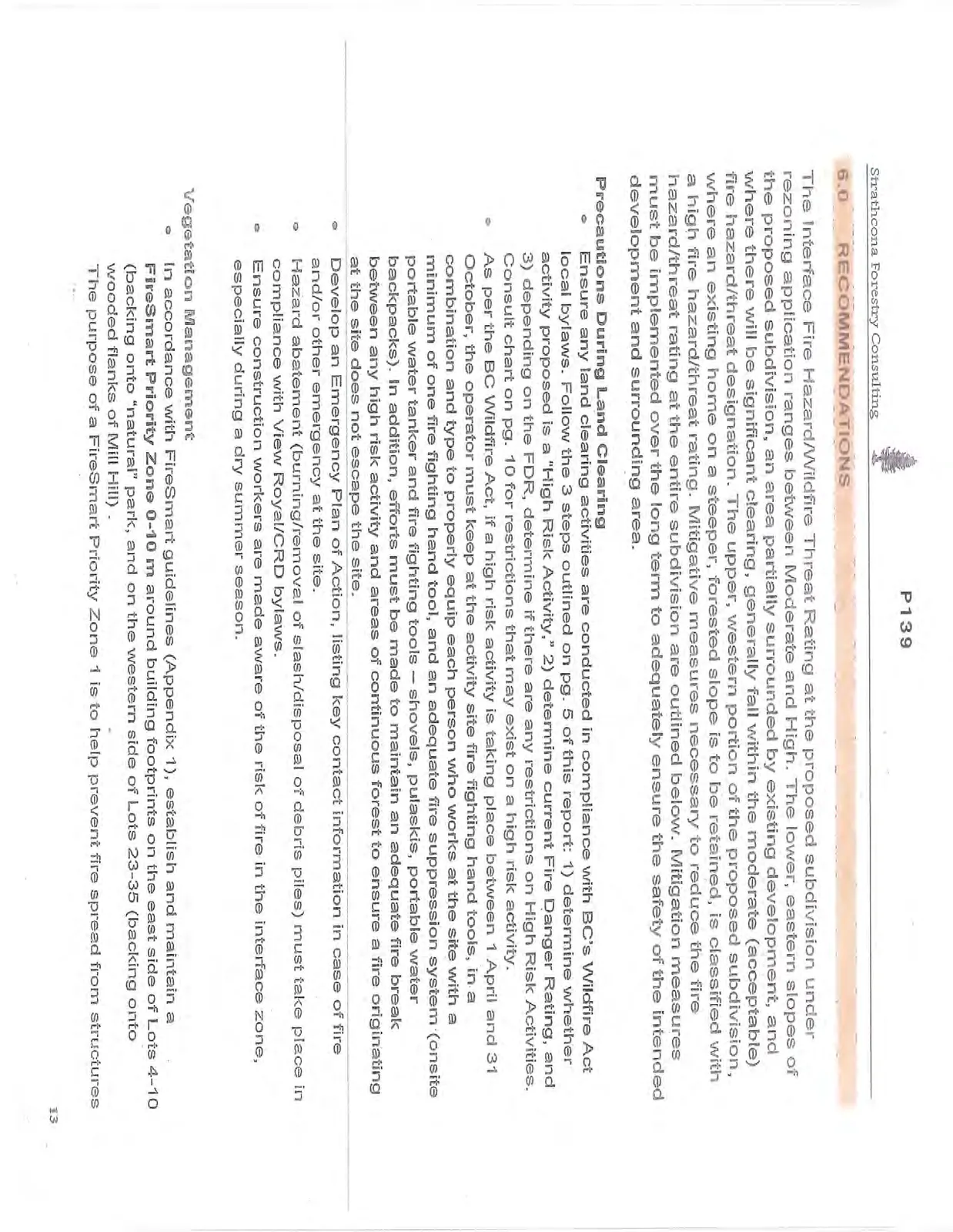
6.0 RECOMMENDATIONS
The Interface Fire Hazard/Wildfire Threat Rating at the proposed subdivision under rezoning application ranges between Moderate and High. The lower, eastern slopes of the proposed subdivision, an area partially surrounded by existing development, and where there will be significant clearing, generally fall within the moderate (acceptable) fire hazard/threat designation. The upper, western portion of the proposed subdivision, where an existing home on a steeper, forested slope is to be retained, is classified with a high fire hazard/threat rating. Mitigative measures necessary to reduce the fire hazard/threat rating at the entire subdivision are outlined below. Mitigation measures must be implemented over the long term to adequately ensure the safety of the intended development and surrounding area.
Precautions During Land Clearing
- Ensure any land clearing activities are conducted in compliance with BC’s Wildfire Act local bylaws. Follow the 3 steps outlined on pg. 5 of this report: 1) determine whether activity proposed is a “High Risk Activity,” 2) determine current Fire Danger Rating, and 3) depending on the FDR, determine if there are any restrictions on High Risk Activities. Consult chart on pg. 10 for restrictions that may exist on a high risk activity.
- As per the BC Wildfire Act, if a high risk activity is taking place between 1 April and 31 October, the operator must keep at the activity site fire fighting hand tools, in a combination and type to properly equip each person who works at the site with a minimum of one fire fighting hand tool, and an adequate fire suppression system (onsite portable water tanker and fire fighting tools – shovels, pulaskis, portable water backpacks). In addition, efforts must be made to maintain an adequate fire break between any high risk activity and areas of continuous forest to ensure a fire originating at the site does not escape the site.
- Develop an Emergency Plan of Action, listing key contact information in case of fire and/or other emergency at the site.
- Hazard abatement (burning/removal of slash/disposal of debris piles) must take place in compliance with View Royal/CRD bylaws.
- Ensure construction workers are made aware of the risk of fire in the interface zone, especially during a dry summer season.
Vegetation Management
- In accordance with FireSmart guidelines (Appendix 1), establish and maintain a FireSmart Priority Zone 0-10 m around building footprints on the east side of Lots 4-10 (backing onto “natural” park, and on the western side of Lots 23-35 (backing onto wooded flanks of Mill Hill). The purpose of a FireSmart Priority Zone 1 is to help prevent fire spread from structures to surrounding vegetation, and vice versa.
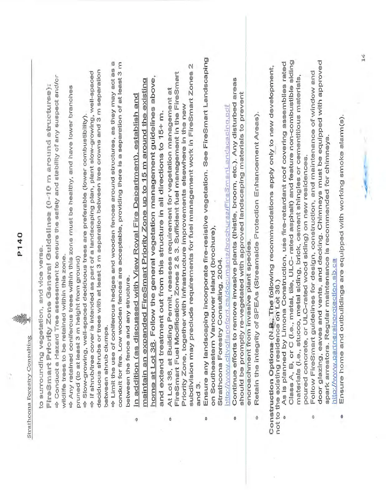
FireSmart Priority Zone General Guidelines (0-10 m around structures):
Conduct a Hazard Tree assessment to ensure the safety and stability of any suspect and/or wildlife trees to be retained within this zone.
Any retained coniferous trees within this zone must be healthy, and have lower branches pruned (to at least 3 m height from ground).
Slow-growing, well-spaced deciduous trees are preferable (lower combustibility).
If shrub/tree cover is intended as part of a landscaping plan, plant slow-growing, well-spaced deciduous shrubs or trees with at least 3 m separation between tree crowns and 3 m separation between shrub clumps.
Limit the use of coniferous hedges and wooden fences around structures, as they may act as a conduit for fire. Low wooden fences are acceptable, providing there is a separation of at least 3 m between the fence and any structure.
In addition (as discussed with View Royal Fire Department), establish and maintain an expanded FireSmart Priority Zone up to 15 m around the existing home at Lot 36. Follow the general vegetation management guidelines above, and extend treatment out from this structure in all directions to 15+ m.
At Lot 36, at Building Permit, reassess requirement for vegetation management at FireSmart Fuel Modification Zones 2 & 3. Sufficient fuel management in the FireSmart Priority Zone, together with infrastructure improvements elsewhere in the new subdivision may preclude requirements for fuel management work in FireSmart Zones 2 and 3.
Ensure any landscaping incorporate fire-resistive vegetation. See FireSmart Landscaping on Southeastern Vancouver Island (brochure), Strathcona Forestry Consulting, 2004. http://www.cityoflangford.ca/documents/brochures/FireSmartLandscaping.pdf
Continue efforts to remove invasive plants (thistle, broom, etc.). Any disturbed areas should be promptly re-vegetated with approved landscaping materials to prevent encroachment from invasive plant species.
Retain the integrity of SPEAs (Streamside Protection Enhancement Areas).
Construction Options
(N.B.: The following recommendations apply only to new development, not to the existing residence on Lot 36.)
- As is planned by Limona Construction, use fire-retardant roof covering assemblies rated Class A, B, or C (i.e., metal, tile, ULC- rated asphalt) and feature non-combustible siding materials (i.e., stucco, metal siding, brick, cement shingles or cementitious materials, poured concrete, or ULC-rated wood siding) on new residences.
- Follow FireSmart guidelines for design, construction, and maintenance of window and door glazing, eaves and vents, and decking. Chimneys must be equipped with approved spark arrestors. Regular maintenance is recommended for chimneys. http://www.partnersinprotection.ab.ca
- Ensure home and outbuildings are equipped with working smoke alarm(s).
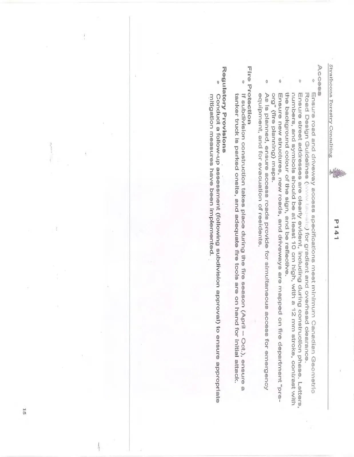
Access
- Ensure road and driveway access specifications meet minimum Canadian Geometric Road Design Guidelines (www.tac-atc) for gradient and overhead clearance.
- Ensure street addresses are clearly evident, including during construction phase. Letters, numbers, and symbols should be at least 10 cm high, with a 12 mm stroke, contrast with the background colour of the sign, and be reflective.
- Ensure new structures, new roads, and driveways are mapped on fire department “pre-org” (fire planning) maps.
- As is planned, ensure access roads provide for simultaneous access for emergency equipment, and for evacuation of residents.
Fire Protection
- If subdivision construction takes place during the fire season (April – Oct.), ensure a tanker truck is parked onsite, and adequate fire tools are on hand for initial attack.
Regulatory Provisions
- Conduct a follow-up assessment (following subdivision approval) to ensure appropriate mitigation measures have been implemented.
APPENDIX 1. FIRESMART INTERFACE PRIORITY ZONES
In interface areas, FireSmart advocates the establishment and maintenance of Fuel Management Zones* extending outward from structures and along access routes: Priority Zone 1 (0-10 m). Priority Zone 2 (10-30 m). Priority Zone 3 (30-100 m).

Priority Zone 1 (0-10 m): The main objective of vegetation management is to create an environment that will not support fire. Vegetation management focuses on fuel removal, conversion, and reduction.
Priority Zone 2 (10-30 m): Where treatment in PZ 1 is not sufficient to significantly reduce the fire hazard due to fuel loading, extend the fuel modified area with a variety of thinning and pruning actions.
Priority Zone 3 (30-100 m): Where fuel modification in PZ1 and PZ2 is insufficient to protect structures and/or property, FireSmart advocates treatment in Priority Zone 3 with a variety of thinning and pruning actions in order to create an environment that will not support high-intensity crown fires.
*Setback Zone distances may be extended depending on aspect, slope, fuel loading, etc.
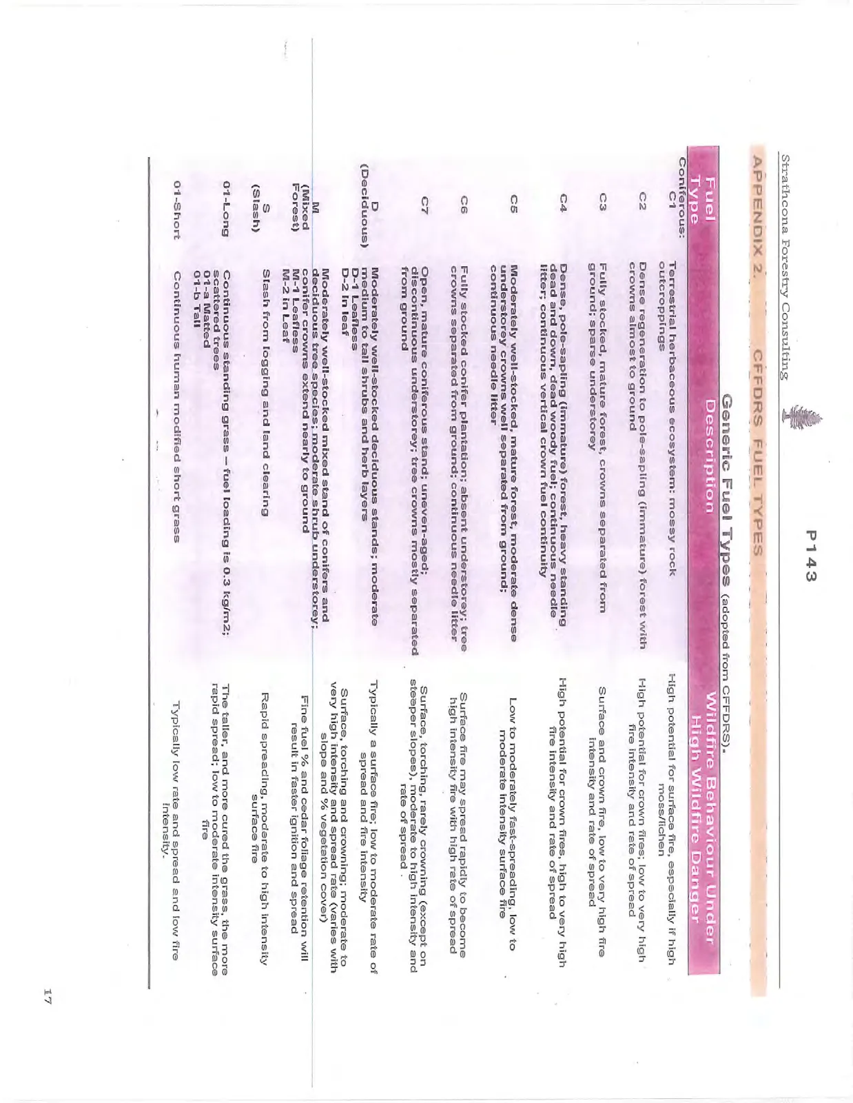
APPENDIX 2. CFFDRS FUEL TYPES
Generic Fuel Types (adopted from CFFDRS)
| Fuel Type | Description | Wildfire Behaviour Under High Wildfire Danger |
|---|---|---|
| Coniferous: | ||
| C1 | Terrestrial herbaceous ecosystem: mossy rock outcroppings | High potential for surface fire, especially if high moss/lichen |
| C2 | Dense regeneration to pole-sapling (immature) forest with crowns almost to ground | High potential for crown fires; low to very high fire intensity and rate of spread |
| C3 | Fully stocked, mature forest, crowns separated from ground; sparse understorey | Surface and crown fire, low to very high fire intensity and rate of spread |
| C4 | Dense, pole-sapling (immature) forest, heavy standing dead and down, dead woody fuel; continuous needle litter; continuous vertical crown fuel continuity | High potential for crown fires, high to very high fire intensity and rate of spread |
| C5 | Moderately well-stocked, mature forest, moderate dense understorey crowns well separated from ground; continuous needle litter | Low to moderately fast-spreading, low to moderate intensity surface fire |
| C6 | Fully stocked conifer plantation; absent understorey; tree crowns separated from ground; continuous needle litter | Surface fire may spread rapidly to become high intensity fire with high rate of spread |
| C7 | Open, mature coniferous stand; uneven-aged; discontinuous understorey; tree crowns mostly separated from ground | Surface, torching, rarely crowning (except on steeper slopes), moderate to high intensity and rate of spread |
| D (Deciduous) | Moderately well-stocked deciduous stands; moderate medium to tall shrubs and herb layers D-1 Leafless D-2 In leaf |
Typically a surface fire; low to moderate rate of spread and fire intensity Surface, torching and crowning; moderate to very high intensity and spread rate (varies with slope and % vegetation cover) |
| M (Mixed Forest) | Moderately well-stocked mixed stand of conifers and deciduous tree species; moderate shrub understorey; conifer crowns extend nearly to ground M-1 Leafless M-2 In leaf |
Fine fuel % and cedar foliage retention will result in faster ignition and spread |
| S (Slash) | Slash from logging and land clearing | Rapid spreading, moderate to high intensity surface fire |
| 01-Long | Continuous standing grass – fuel loading is 0.3 kg/m2; scattered trees 01-a Matted 01-b Tall |
The taller, and more cured the grass, the more rapid spread; low to moderate intensity surface fire |
| 01-Short | Continuous human modified short grass | Typically low rate and spread and low fire intensity. |
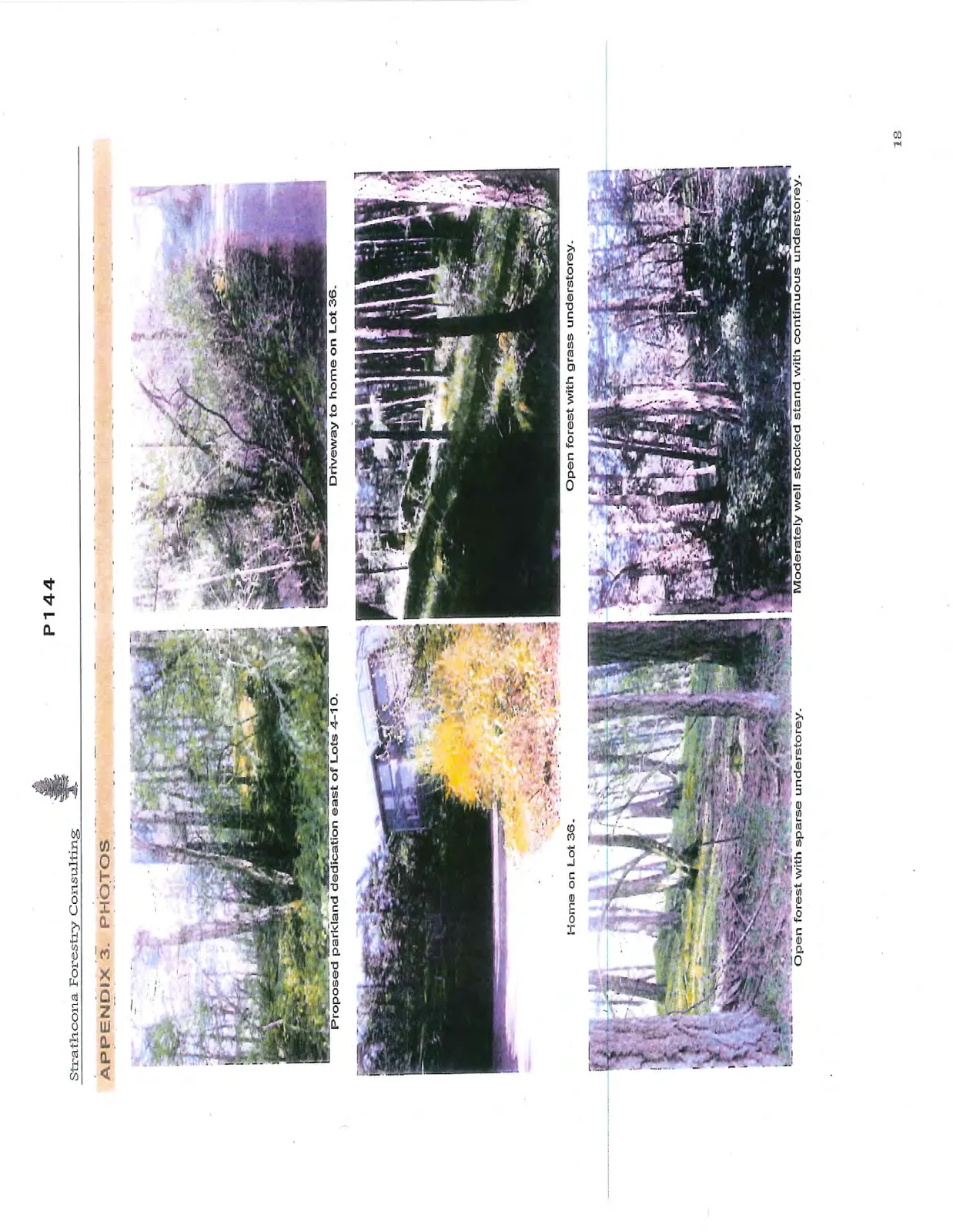
APPENDIX 3. PHOTOS
LIMITATIONS
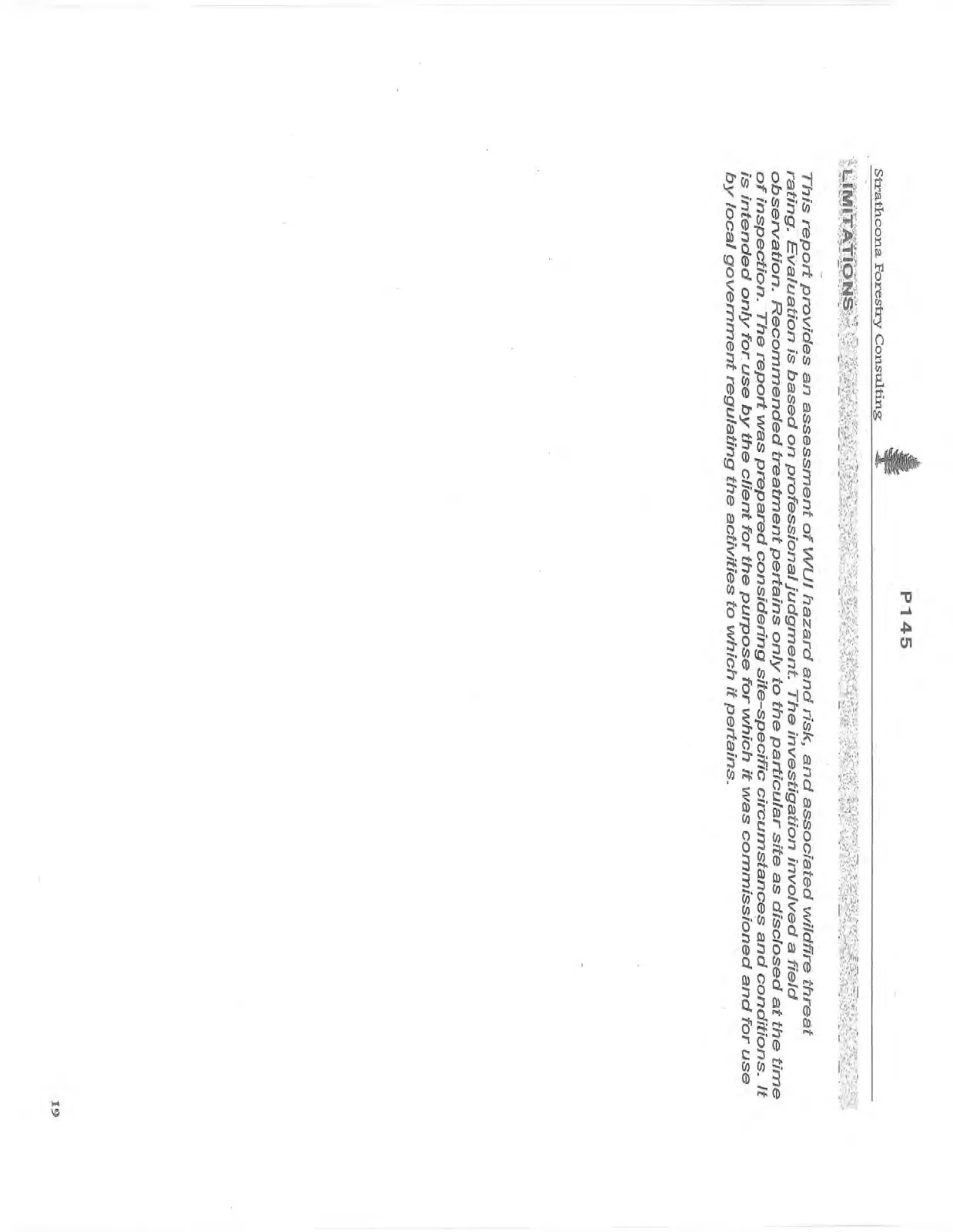
This report provides an assessment of WUI hazard and risk, and associated wildfire threat rating. Evaluation is based on professional judgment. The investigation involved a field observation. Recommended treatment pertains only to the particular site as disclosed at the time of inspection. The report was prepared considering site-specific circumstances and conditions. It is intended only for use by the client for the purpose for which it was commissioned and for use by local government regulating the activities to which it pertains.
Document Images
(15)