Council Report - DEVELOPMENT PERMIT 2014/07 – 1652 ISLAND HIGHWAY
A report regarding a development permit application for a commercial addition to an existing building, including requests for variances.
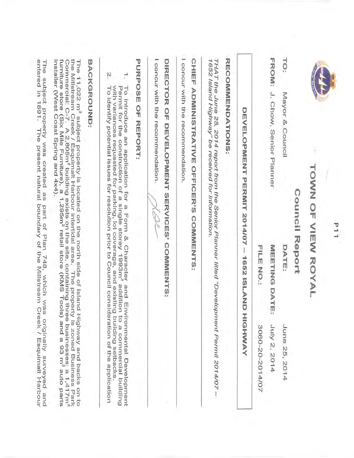
TO: Mayor & Council FROM: J. Chow, Senior Planner DATE: June 25, 2014 MEETING DATE: July 2, 2014 FILE NO.: 3060-20-2014/07
DEVELOPMENT PERMIT 2014/07 – 1652 ISLAND HIGHWAY
RECOMMENDATIONS:
THAT the June 25, 2014 report from the Senior Planner titled "Development Permit 2014/07 – 1652 Island Highway" be received for information.
CHIEF ADMINISTRATIVE OFFICER'S COMMENTS:
I concur with the recommendation.
DIRECTOR OF DEVELOPMENT SERVICES' COMMENTS:
I concur with the recommendation.
PURPOSE OF REPORT:
- To introduce an application for a Form & Character and Environmental Development Permit for the construction of a single storey 1993 m² addition to a commercial building with variances requested for parking, lot coverage, and existing building setbacks.
- To identify potential issues for resolution prior to Council consideration of the application
BACKGROUND:
The 11,022 m² subject property is located on the north side of Island Highway and backs on to the Millstream Creek / Esquimalt Harbour intertidal area. The property is zoned Business Park Commercial: C-7. A 2,805 m² building exists on the site, containing three businesses; a 1,417 m² furniture store (Six Mile Furniture), a 1,295 m² retail store (KMS Tools) and a 93 m² auto parts installer (West Coast Spring and 4x4).
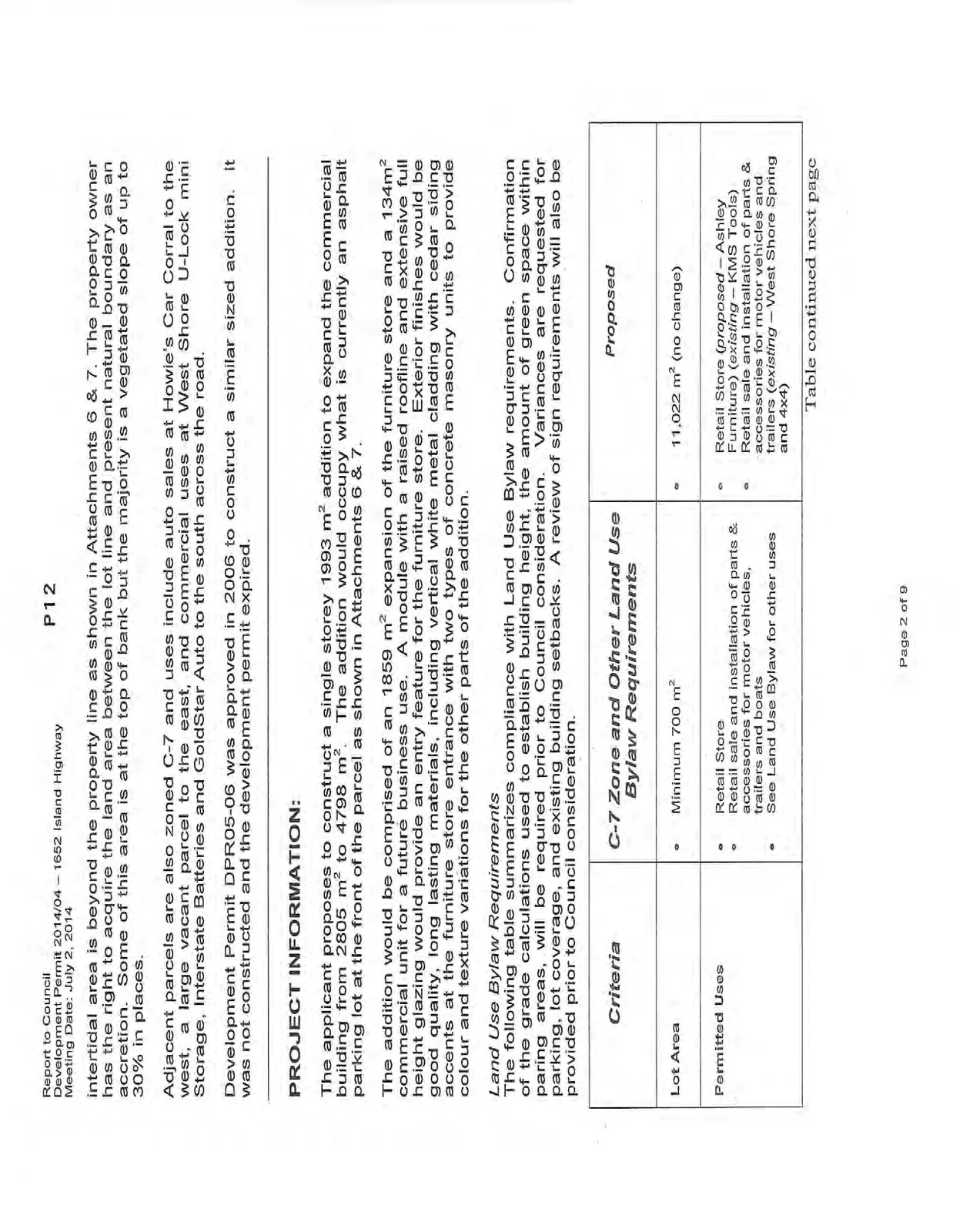
The subject property was created as part of Plan 748, which was originally surveyed and entered in 1891. The present natural boundary of the Millstream Creek / Esquimalt Harbour intertidal area is beyond the property line as shown in Attachments 6 & 7. The property owner has the right to acquire the land area between the lot line and present natural boundary as an accretion. Some of this area is at the top of bank but the majority is a vegetated slope of up to 30% in places.
Adjacent parcels are also zoned C-7 and uses include auto sales at Howie’s Car Corral to the west, a large vacant parcel to the east, and commercial uses at West Shore U-Lock mini Storage, Interstate Batteries and GoldStar Auto to the south across the road.
Development Permit DPR05-06 was approved in 2006 to construct a similar sized addition. It was not constructed and the development permit expired.
PROJECT INFORMATION:
The applicant proposes to construct a single storey 1993 m² addition to expand the commercial building from 2805 m² to 4798 m². The addition would occupy what is currently an asphalt parking lot at the front of the parcel as shown in Attachments 6 & 7.
The addition would be comprised of an 1859 m² expansion of the furniture store and a 134 m² commercial unit for a future business use. A module with a raised roofline and extensive full height glazing would provide an entry feature for the furniture store. Exterior finishes would be good quality, long lasting materials, including vertical white metal cladding with cedar siding accents at the furniture store entrance with two types of concrete masonry units to provide colour and texture variations for the other parts of the addition.
Land Use Bylaw Requirements
The following table summarizes compliance with Land Use Bylaw requirements. Confirmation of the grade calculations used to establish building height, the amount of green space within paring areas, will be required prior to Council consideration. Variances are requested for parking, lot coverage, and existing building setbacks. A review of sign requirements will also be provided prior to Council consideration.
| Criteria | C-7 Zone and Other Land Use Bylaw Requirements | Proposed |
|---|---|---|
| Lot Area | Minimum 700 m² | 11,022 m² (no change) |
| Permitted Uses | • Retail Store • Retail sale and installation of parts & accessories for motor vehicles, trailers and boats • See Land Use Bylaw for other uses |
• Retail Store (proposed – Ashley Furniture) (existing – KMS Tools) • Retail sale and installation of parts & accessories for motor vehicles and trailers (existing – West Shore Spring and 4x4) |
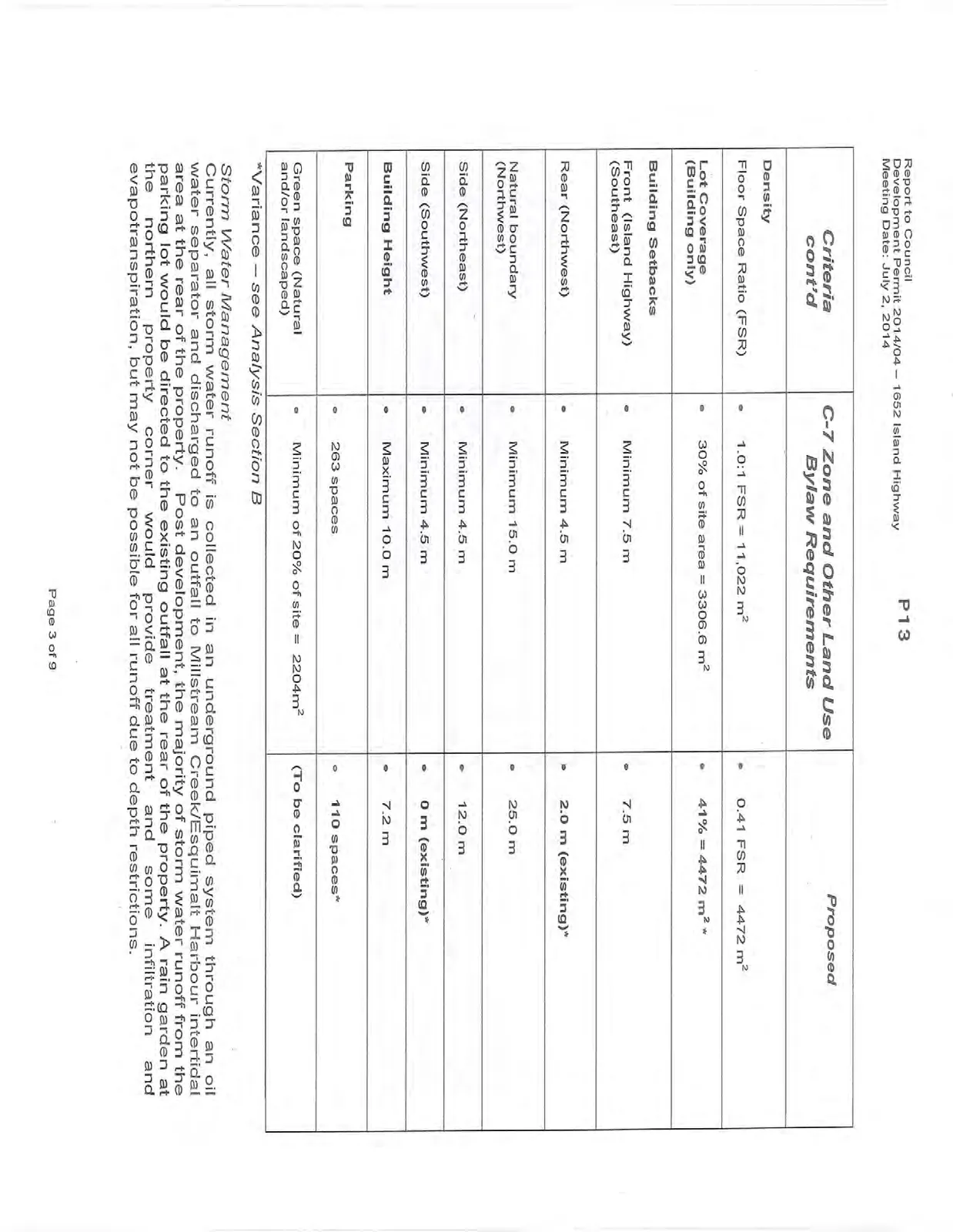
| Density | ||
| Floor Space Ratio (FSR) | 1.0:1 FSR = 11,022 m² | 0.41 FSR = 4472 m² |
| Lot Coverage (Building only) | 30% of site area = 3306.6 m² | 41% = 4472 m² * |
| Building Setbacks | ||
| Front (Island Highway) (Southeast) | Minimum 7.5 m | 7.5 m |
| Rear (Northwest) | Minimum 4.5 m | 2.0 m (existing)* |
| Natural boundary (Northwest) | Minimum 15.0 m | 25.0 m |
| Side (Northeast) | Minimum 4.5 m | 12.0 m |
| Side (Southwest) | Minimum 4.5 m | 0 m (existing)* |
| Building Height | Maximum 10.0 m | 7.2 m |
| Parking | 263 spaces | 110 spaces* |
| Green space (Natural and/or landscaped) | Minimum of 20% of site = 2204m² | (To be clarified) |
*Variance – see Analysis Section B
Storm Water Management
Currently, all storm water runoff is collected in an underground piped system through an oil water separator and discharged to an outfall to Millstream Creek/Esquimalt Harbour intertidal area at the rear of the property. Post development, the majority of storm water runoff from the parking lot would be directed to the existing outfall at the rear of the property. A rain garden at the northern property corner would provide treatment and some infiltration and evapotranspiration, but may not be possible for all runoff due to depth restrictions.
Runoff from the roof of the proposed addition would be directed to the piped system and treated by mechanical means. Additional storm water detention is not proposed as there would be no net increase in runoff. Infiltration trenches will be considered where ground conditions permit to reduce the total runoff volume and recharge groundwater.
Landscaping
The areas along the front and side lot lines would be intensively planted with shrubs and ground cover. The only lawn areas on the site would be narrow strips that would tie into the grass boulevard.
The vegetation on the slope at the rear of the property would be largely undisturbed in accordance with the biologists report because it is thick and is essential for slope stability. There are relatively low amounts of invasive species.
Frontage Improvements
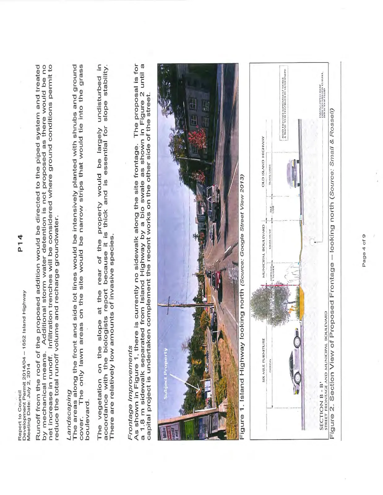
As shown in Figure 1, there is currently no sidewalk along the site frontage. The proposal is for a 1.8 m sidewalk separated from Island Highway by a bio swale as shown in Figure 2 until a capital project is undertaken complement the recent works on the other side of the street.
ANALYSIS:
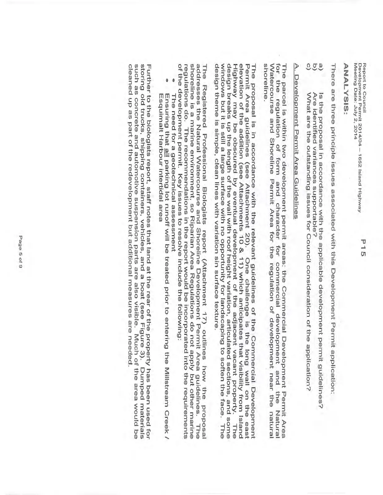
There are three principle issues associated with this Development Permit application:
a) Is the proposal in accordance with the applicable development permit guidelines? b) Are identified variances supportable? c) What are the outstanding issues for Council consideration of the application?
A. Development Permit Area Guidelines
The parcel is within two development permit areas: the Commercial Development Permit Area for the regulation of form and character for commercial development and the Natural Watercourse and Shoreline Permit Area for the regulation of development near the natural shoreline.
The proposal is in accordance with the relevant guidelines of the Commercial Development Permit Area guidelines (see Attachment 20). One challenge is the long wall on the east elevation of the addition (see Attachments 10 & 11) which anticipates that visibility from Island Highway may be obscured by eventual development of the adjacent vacant property. The design breaks up the length of the wall with roof height variation, articulated sections, and some windows but it is still a large surface with no opportunity for landscaping to soften the face. The design theme is simple, clean lines with variation sin surface texture.
The Registered Professional Biologists report (Attachment 17) outlines how the proposal addresses the Natural Watercourse and Shoreline Development Permit Area guidelines. The shoreline is a marine environment, so Riparian Area Regulations do not apply but other marine regulations do. The recommendations in the report would be incorporated into the requirements of the development permit. Key issues to resolve include the following:
- The need for a geotechnical assessment
- Ensuring that all parking lot runoff will be treated prior to entering the Millstream Creek / Esquimalt Harbour intertidal area
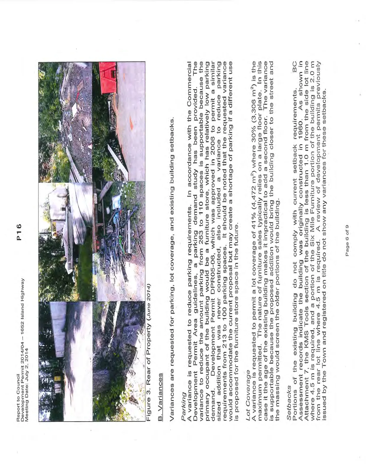
Further to the biologists report, staff notes that land at the rear of the property has been used for storing old trucks, shipping containers, vehicles, and a boat (see Figure 3). Dumped materials such as concrete and automotive suspension parts are also visible. Much of the area would be cleaned up as part of the redevelopment but additional measures are needed.
B. Variances
Variances are requested for parking, lot coverage, and existing building setbacks.
Parking
A variance is requested to reduce parking requirements. In accordance with the Commercial Development Permit Area guidelines, a parking demand study has been provided. The variance to reduce the amount parking from 263 to 110 spaces is supportable because the primary occupant of the building would be a furniture store, which has relatively low parking demand. Development Permit DPR05-06, which was approved in 2006 to permit a similar sized addition that was never constructed, also included a variance to reduce parking requirements from 213 to 100 parking spaces. It should be noted that the requested variance would accommodate the current proposal but may create a shortage of parking if a different use is proposed for the furniture store space in the future.
Lot Coverage
A variance is requested to permit a lot coverage of 41% (4,472 m²) where 30% (3,306 m²) is the maximum permitted. The nature of furniture sales typically relies on a large floor plate. In this case it the age of the existing building makes it impractical to add a second floor. The variance is supportable because the proposed addition would bring the building closer to the street and the massing would screen the older portions of the building.
Setbacks
Portions of the existing building do not comply with current setback requirements. BC Assessment records indicate the building was originally constructed in 1960. As shown in Attachment 7, the KMS Tools section of the building is less than 1.0 m from the side lot line where 4.5 m is required, and a portion of the Six Mile Furniture portion of the building is 2.0 m from the rear lot line where 4.5 m is required. A review of development permits previously issued by the Town and registered on title do not show any variances for these setbacks.
Variances should be considered to formalize portions of the existing building that do not comply with the current C-7 zone to acknowledge the siting. The proposed development does not require any modifications to these portions of the building.
C. Outstanding Issues
Staff is working with the application to finalize a number of details prior to Council consideration of the application. In general the details are not significant but are necessary to confirm that bylaw requirements or development permit area guidelines are fully addressed. These include the following:
- A geotechnical assessment of the proposal
- Ensuring that all parking lot runoff will be treated prior to entering the Millstream Creek / Esquimalt Harbour intertidal area
- More detail on storm water treatment
- Frontage improvements
- Building grade calculations
- Amount of green space (20% of lot area and 10% within parking areas required)
- Sign plan details (type and material specifications)
- Confirmation of how lighting guidelines would be addressed
- Location and screening details of outdoor solid waste and recycling storage facilities
- Replace four proposed Sugar maples with approved trees listed in the C-7 zone
Once the above information is provided, this application can be considered by Council subject to any comments from the Council meeting and notice requirements of the Local Government Act and Development Procedures Bylaw No. 730, 2009.
RECOMMENDATION:
THAT the June 25, 2014 report from the Senior Planner titled "Development Permit 2014/07 – 1652 Island Highway" be received for information.
ATTACHMENTS:
- Subject Property Map
- Letter to Mayor and Council from Omicron AEC – May 5, 2014 (8 pages)
- Six Mile Furniture (Title Sheet), Omicron AEC – May 5, 2014
- A1.1 Context Plan and Project Data and Context Photos, Omicron AEC – May 5, 2014
- A1.2 Contextual Street Photos, Omicron AEC – May 5, 2014
- Site Plan, Powell and Associates – April 4, 2014
- A2.1 Site Plan, Omicron AEC – May 5, 2014
- A2.2 Main Floor Plan, Omicron AEC – May 5, 2014
- A2.3 Roof Plan, Omicron AEC – May 5, 2014
- A3.1 Building Renderings, Omicron AEC – May 5, 2014
- A3.2 Building Elevations, Omicron AEC – May 5, 2014
- A4.1 Building Sections, Omicron AEC – May 5, 2014
- DP-C-01 Conceptual Servicing Plan, WSP Canada – April 29, 2014
- L1 Landscape Plan, Small & Rossell Landscape Architects, May 5, 2014
- L2 Landscape Cross Sections, Small & Rossell Landscape Architects, May 5, 2014
- Colour and Materials Board, Omicron AEC – May 5, 2014
- Natural Watercourse and Shoreline Memo, Aqua-Tex Scientific Consulting – May 2, 2014
- Six Mile Furniture Parking Study, Boulevard Transportation – May 1, 2014 (10 pages)
- Sustainability Checklist, Omicron AEC – May 5, 2014 (pages)
- Development Permit Guideline Review, Town of View Royal Development Services
Document Images
(6)