STORM WATER MANAGEMENT PLAN for Eagle Nest Residences
Technical report outlining the approach and strategy for managing storm water runoff for the multi-unit residential redevelopment.
STORM WATER MANAGEMENT PLAN
for
Eagle Nest Residences (#3 & 5 Helmcken Road and #1449 Burnside Road, View Royal)
Prepared for: Helmcken Rd Development BC Ltd. #200 – 1501 First Street SW Calgary, AB T2R 0W1
Prepared by: McElhanney Ltd. #500 – 3960 Quadra Street Victoria, BC V8X 4A3
Date: October 28, 2021
Table of Contents
- Introduction................................................................................................................................................... 3
- Existing Conditions ........................................................................................................................................ 4
- General Storm Water Management Approach ............................................................................................. 5
- Storm Water Management Strategy ............................................................................................................. 5 4.1. Natural, Revegetated and Landscaped Areas ....................................................................................... 5 4.2. Building and Hardscaped (Non-vehicular) Areas................................................................................... 5 4.3. Hardscaped (Vehicular Accessible) Areas.............................................................................................. 6
- Stormwater Quantity Control........................................................................................................................ 6 5.1. Pre-development Runoff....................................................................................................................... 6 5.2. Post Development Runoff ..................................................................................................................... 7 5.3. Stormwater Detention........................................................................................................................... 8
- Stormwater Quality (Treatment)................................................................................................................... 8
- Erosion and Sediment Control During Construction ..................................................................................... 8 7.1. Silt Fences-Perimeter Ditching .............................................................................................................. 9 7.2. Sediment Control Ponds...................................................................................................................... 10 7.3. Slope and Surface Protection .............................................................................................................. 10
1. Introduction
McElhanney Ltd. (McElhanney) has been retained by Helmcken Rd. Development BC Ltd. (Client) to provide a Storm Water Management Plan for the properties located at 3 and 5 Helmcken Road and 1449 Burnside Road in the Town of View Royal.
The purpose of this report is to support an application for a redevelopment on the subject property.
The development combines the three existing lots into one 1.38-hectare property. The development will include:
- 3 – four to six storey residential multi-unit buildings
- Under building parking
The site is bounded to the east and north with undeveloped land (farms). The lots to the south and west are residential townhomes and single-family dwellings.
This Storm Water Management Plan will:
- Review the existing surface drainage conditions.
- Consider the approach to be used for storm water management.
- Describe a proposed storm water management strategy.
2. Existing Conditions
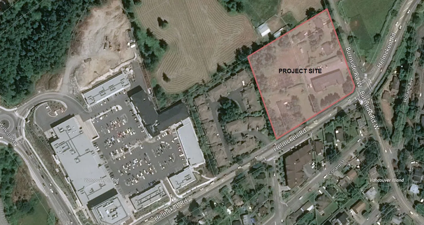
The existing site includes a residential apartment building and a couple of single family dwellings, see Figure 1.
The terrain generally slopes to the south west, from 1 to 5%, away from Burnside Road. There is an existing rock knoll near the south west corner.
Surface drainage from adjacent properties do not appear to discharge onto the property. Road drainage along Burnside Road generally flows to roadside ditches which connect to a municipal drain system. There appear to be unrecorded storm drains in the area connecting drainage from Burnside Road to Helmcken Road. Additional investigation such as camera inspection or ground penetrating radar may be required to determine details of the existing municipal drainage system.
3. General Storm Water Management Approach
The proposed developments’ Storm Water Management Plan will be a collaboration between the design professionals (Civil Engineer, Arborist, Landscape Architect, Geotechnical Engineer) and the Town of View Royals staff (Engineering, Parks, Planning). The approach taken will address and promote the following:
- Detain post-development runoff to pre-development runoff rates
- Provide storm water systems that promote ground water recharge
- Minimize impacts to storm water quality
- Minimize sedimentation and erosion, stabilize and re-vegetate impacted areas
- Consider impacts of extreme rainfall (1 in 200 year) events
4. Storm Water Management Strategy
The proposed storm water management facilities will separate rainfall on the development into three general categories:
- Natural, Revegetated and Landscaped areas
- Building and Hardscaped (non-vehicular) areas
- Hardscaped (vehicular accessible) areas
4.1. Natural, Revegetated and Landscaped Areas
Rainfall runoff in these areas will be encouraged to follow the natural terrain of the area and infiltrate into the ground. No additional runoff from pre-development conditions anticipated for these areas.
4.2. Building and Hardscaped (Non-vehicular) Areas
Rainfall runoff in these areas will be directed to area drains and landscaped area. The runoff will ultimately be directed to either of the two proposed rain gardens for detention, prior to discharge to the municipal drainage system with orifice-controlled outlets to limit flows to the 2 and 10-year existing (pre-development) rates. The intent is to utilize rain gardens to promote infiltration (to the extent possible given the soil conditions) and provide detention. Designed overflow facilities will be provided for events greater than 10-year return. Major storm events (200-year event) will be directed overland.
4.3. Hardscaped (Vehicular Accessible) Areas
Rainfall runoff in these areas will be directed to area drains and routed through oil / water separators. The runoff will ultimately be directed to either of the two proposed rain gardens for detention, prior to discharge to the municipal drainage system with orifice-controlled outlets to limit flows to the 2 and 10-year existing (pre-development) rates. The intent is to utilize rain gardens to promote infiltration (to the extent possible given the soil conditions) and provide detention. Designed overflow facilities will be provided for events greater than 10-year return. Major storm events (200-year event) will be directed overland.
Minor regrading of the existing ditch along Burnside Road is proposed. Road runoff from Burnside Road will be directed to this ditch via curb cutouts.
5. Stormwater Quantity Control
5.1. Pre-development Runoff
Calculation of the pre-development runoff is contingent on the site’s runoff coefficient value. As shown on Figure 1, the pre-development condition of the site was a mix of flat undeveloped areas, rock knoll, buildings, and gravel / asphalt driving surfaces.
Typical C Coefficients*
| Description of Area | Runoff Coefficients Range | Runoff Coefficients Selected | Contributing Area (m²) | C x A |
|---|---|---|---|---|
| *Asphalt (d/w, parking) | 0.70 - 0.95 | 0.95 | 1160 | 1102 |
| *Gravel (d/w, paths) | 0.75 | 0.75 | 1200 | 900 |
| *Buildings | 0.75 - 0.95 | 0.95 | 970 | 922 |
| *Lawns, Average 2-7% | 0.18 – 0.20 | 0.20 | 9630 | 1926 |
| *Rock knoll, 10-30%, tree cover | 0.75 | 0.75 | 800 | 600 |
| Contributing Area (ha) = | (13760 m²) 1.38 ha | |||
| Pre-development C = | 0.40 |
Based on the Rational Method, the resultant pre-development flows from the site are calculated based on the following:
Document Images
(2)