Minutes of the Council meeting held March 15, 2022
Official record of the proceedings from the View Royal Town Council meeting held on March 15, 2022.
As expected, with the post-development runoff coefficient greater than that of the pre-development, the resultant post-development flows are higher. As such, storm water detention with flow-controlled release is proposed to reduce the 2- and 10-year rainfall event peak runoff rates to match pre-development levels.
5.3. Stormwater Detention
The development is proposing two rain gardens, each with an orifice-controlled outlet to restrict the post development runoff to the peak pre-development runoff rates. The size of the orifices will be determined during detailed design as it is directly related to the onsite grading and contributing area to each rain garden.
The minimum required total detention volume, based on the controlled release rates and calculations above, are:
- 13.5 cu.m. for 1 in 2-year storm events
- 21.1 cu.m. for 1 in 10-year storm events
Based on the preliminary design, the rain garden near the Helmcken Road and Burnside Road intersection will have a storage volume of ~ 20 cu.m. (not including the detention within the soil) and the western rain garden along Helmcken Road will have a storage volume of ~ 8 cu.m. (not including the detention within the soil). These volumes exceed the necessary volume noted above.
6. Stormwater Quality (Treatment)
Storm water from the developments hardscaped (vehicular access) areas will be treated through oil / water separators prior to entering the storm water infiltration / detention system.
7. Erosion and Sediment Control During Construction
A key factor in erosion and sediment control is the interception and management of site runoff. Careful planning of construction site activities and phasing, to prevent the generation of erosion, is more effective and less expensive than downstream sediment control with sediment ponds only. Sediment ponds should be considered the last line of defense.
As outlined in the "Land Development Guidelines for Protection of Aquatic Habitat", the following general principles will be required at this site:
- Where possible, conduct earthworks activities during dry months of the year
- Stage activities to allow "green-up" or re-establishment of vegetation and minimize bare areas
- Halt construction during periods of significant precipitation and runoff
- Restrict vehicular/equipment access or provide working surfaces/roads. At each access point to the development site, a sediment pond or trap should be constructed to retain wash down water and sediments that may flow down the adjacent catchment to the access point.
- Retain existing vegetation until excavation commences, i.e. do not strip vegetation long before the following activities
- Minimize clearing and stripping areas
- Physically mark clearing boundaries on the construction site
- Seed or re-vegetate cut and fill slopes, and disturbed natural areas
- Cover temporary fills or stockpiles with sheeting or tarps and/or use silt fence surround
- Use mulches and other organic stabilizers to minimize erosion until
- Vegetation is established
- Plan seeding and planting to allow establishment before the end of the growing season
The following site-specific control measures are suggested to be included when the contractor produces the Erosion and Sediment control plan:
7.1. Silt Fences-Perimeter Ditching
Silt fences provide an effective filter for sediment laden runoff from bare soil slopes and surfaces. Silt fences are effective boundary control devices, trapping the sediment close to the erosion source and reducing the mobilization into runoff.
Silt fences should be installed along the downstream edges of activity, lower property lines and at the top of the slope to the foreshore. In temporary runoff control ditches and in proposed bio-swales, silt fences may be overwhelmed by the quantity of runoff and should be reconsidered, in favour of traps or rock berms, particularly where ditch slopes are steeper than approximately 3%.
Adequacy of the silt fence locations should be confirmed in the field, inspected and maintained on a regular basis as construction proceeds.
7.2. Sediment Control Ponds
Sediment control ponds are the last line of defense before runoff is discharged from the development site.
Sediment ponds should ideally be a minimum of 1% of the contributing catchment area and be as large as practical within the topographical constraints of the site. Catchment boundaries and proposed locations of the sediment ponds will be shown on the detailed design drawings. Adequacy of the proposed sediment ponds should be reviewed in the field.
7.3. Slope and Surface Protection
The required protection will be determined by the type of material, the grade of slope, and the expected exposure time, and shall be in accordance with the "Land Development Guidelines for Protection of Aquatic Habitat".
In dry conditions, all cut/fill and cleared natural slopes and surfaces should have erosion controls implemented within 14 days.
In wet conditions, erosion control should be implemented immediately on completion of the grading operations of the area.
Slopes exceeding 3.0 meters in height and steeper than 2H:1V should be reviewed by a Professional Engineer, to assess slope stability, erosion, and drainage control requirements.
This report has been prepared by:
McELHANNEY CONSULTING SERVICES LTD.
Ian McCall, PEng, Project Manager imccall@mcelhanney.com 250 370-9221
EAGLE NEST DEVELOPMENT
Traffic Impact Assessment Update
Author: D. Ridsdale, BA, CTech. Reviewer: N. King, P. Eng, PTOE
Prepared for: Invictus Commercial Investment Corp Our File: 2497.B01 Date: January 10, 2019
#501-740 Hillside Avenue Victoria, BC V8T 1Z4 T 250.388.9877 F 250.388.9879 wattconsultinggroup.com
TABLE OF CONTENTS
1.0 INTRODUCTION ................................................................................................... 1 2.0 EXISTING CONDITIONS ...................................................................................... 2 3.0 BACKGROUND VOLUMES AND CONDITIONS ................................................. 4 4.0 POST DEVELOPMENT CONDITIONS................................................................. 7 5.0 TRANSPORTATION DEMAND MANAGEMENT ............................................... 13 6.0 CONCLUSIONS.................................................................................................. 15 7.0 RECOMMENDATIONS....................................................................................... 16
APPENDICES
Appendix A: Synchro Background Appendix A: Synchro Background
LIST OF FIGURES
Figure 1: Study Area and Site Location...................................................................................... 1 Figure 2: 2018 Existing Volumes and Levels of Service ............................................................. 4 Figure 3: Proposed Site Plan and Access .................................................................................. 7 Figure 4: Site Trip Assignment for Peak Hours..........................................................................10
LIST OF TABLES
Table 1: 2023 Background Conditions ....................................................................................... 6 Table 2: 2033 Background Conditions ....................................................................................... 6 Table 3: AM Peak Hour Trip Generation .................................................................................... 8 Table 4: PM Peak Hour Trip Generation .................................................................................... 8 Table 5: 2023 Post Development Conditions ............................................................................11 Table 6: 2033 Post Development Conditions ............................................................................12
1.0 INTRODUCTION
Watt Consulting Group was retained by Invictus Commercial Investment to update the traffic impact assessment for the Eagle Nest development on the northwest corner of Helmcken Road/ Burnside Road West in the Town of View Royal, BC. This update assesses existing traffic conditions, post development traffic conditions for both short and long term horizon years, the proposed site access as well as Transportation Demand Management strategies for the site.
1.1 STUDY AREA
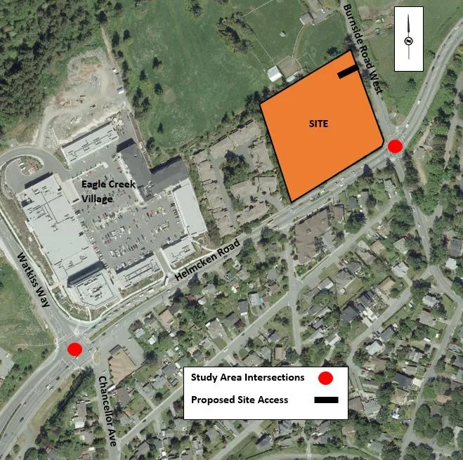
The study area for this project includes the Helmcken Road/ Burnside Road West and Helmcken Road/ Watkiss Way / Chancellor Avenue intersections. Burnside Road West within the study area is a municipal boundary between the Town of View Royal and District of Saanich. Figure 1 shows the site’s location and study area intersections.
Document Images
(3)