TOWN OF VIEW ROYAL COUNCIL REPORT: DEVELOPMENT PERMIT 2021/18 - 2000 WEST PARK LANE (WEST PARK ONE)
A staff report recommending approval for Phase 4 of the 'West Park at Thetis' development, including several variances for retaining walls and setbacks.
TOWN OF VIEW ROYAL COUNCIL REPORT
TO: Council DATE: July 14, 2022 FROM: J. Chow, Senior Planner MEETING DATE: July 19, 2022 FILE NO.: 3060-20-2021/18
DEVELOPMENT PERMIT 2021/18 - 2000 WEST PARK LANE (WEST PARK ONE)
RECOMMENDATION
THAT Development Permit 2021/18 be approved as per the July 14, 2022 report form the Senior Planner titled “Development Permit 2021/18 - 2000 West Park Lane (West Park One)”;
AND THAT Development Permit 2021/18 include the following variances: Development Permit 2021/08 addresses the following variances to Zoning Bylaw No. 900, 2014:
- Variance to the maximum the height of a retaining wall from 1.2m to 2m (Section 4.8.9)
- Variance to the retaining wall vertical height to horizontal spacing from 1:1 to 1:0.75 (Section 4.8.10)
- Variance to the front lot line setback from 6m to 5.5m (Section 13.23.1)
- Variance to the rear lot line setback from 6m to 5.4m (Section 13.23.1)
- Variance to the south side lot line setback from 4.5m to 4.1m (Section 13.23.1);
AND FURTHER THAT Development Permit 2021/18 include the following conditions:
- Roof top mechanical units are to be visually screened.
- Site and building exterior lighting is to be dark skies friendly.
- A security deposit for hard and soft on-site landscaping is required prior to building permit issuance.
- Environmental impacts and mitigation measures including steep slope and interface fire hazard management be implemented in accordance with Development Permits 2019/02 and 2020/10.
- The security deposit of $50,000 provided in Development Permit No 2019/02 to address any unsafe conditions or damage to the natural environment will apply to the works authorized in this development permit.
CHIEF ADMINISTRATIVE OFFICER’S COMMENTS
I concur with the recommendation.
DIRECTOR OF DEVELOPMENT SERVICES’ COMMENTS
I concur with the recommendation.
DIRECTOR OF ENGINEERING’S COMMENTS
I concur with the recommendation.
PURPOSE OF REPORT
- To consider approval of a development permit to construct a five-storey condominium apartment building with two levels of underbuilding parking comprising Phase 4 of the “West Park at Thetis” comprehensive development.
- To consider variances for retaining wall spacing and height and for setbacks in relation to a phased strata declaration.
BACKGROUND
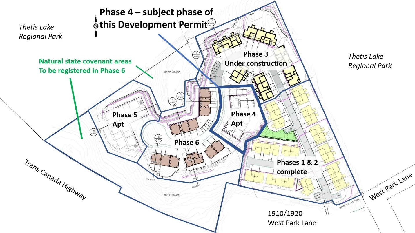
The proposed development site is part of “West Park at Thetis,” a 4.26 ha comprehensive residential development north of Trans Canada Highway and that backs on to Thetis Lake Regional Park (Attachment 1). The west half of the parcel is primarily hilly, forested terrain. It features a rocky hilltop that will be preserved by covenant. Thetis Lake Campground operated for decades on the east half of the property until 2018.
The comprehensive development was rezoned to CD-23: Comprehensive Development (Thetis Lake) in 2017 to permit a total of 350 residential units on this parcel and the adjacent Capital Regional District Housing Corporation rental apartment property at 1910/1920 West Park Lane. Access for the comprehensive development is via West Park Lane by easement over 1910/1920 West Park Lane.
Previously issued development permits relevant to this phase include:
- Development Permit 2019/02 - permitted subdivision to create this parcel and set out requirements for:
- identification of environmentally sensitive areas to be protected
- a security deposit for any unsafe conditions or damage to the natural environment
- interface fire hazard management
- Development Permit 2020/10 - authorized site grading and clearing of this phase and future phases 5-6. It also included requirements for:
- geotechnical oversight
- covenants for safety inspection and maintenance of cut slopes and retaining walls
- considering of safety, scale, and timing of blasting in regard to the earthen dam at Thetis Lake Regional Park.
The site forms Phase 4 of a phased strata as shown in Figure 1. Each of the six phases is incorporated into one strata plan (EPS8048) as buildings are completed. Phase boundaries are treated like lot lines, although once the phase completes, many of the variances will be eliminated as it becomes part of the strata plan.
This proposal was introduced at the March 8, 2022 Committee of the Whole meeting.
PROJECT INFORMATION
The proposal is for 48 units of strata condominium (apartment) development with two levels of underbuilding parking as shown in Attachments and Figures 2-3.
Unit Mix
- 24 one-bedroom
- 1 one-bedroom plus den
- 14 two-bedroom
- 9 two-bedroom plus den
The applicant has submitted the following information in support of their application:
- Site location map
- Air photo
- Letter to Mayor and Council – dhk Architects – November 25, 2021
- Architectural Drawings – dhk Architects – June 3, 2022 (updated)
- Landscape Drawings – LADR Landscape Architects – October 29, 2021
- Civil Engineering Drawings – Associated Engineering – November 25, 2021
Landscape Design
There is little space available on-site for vegetated landscaping and there are no trees to be retained at this building site because the land was cleared and regraded to accommodate gradient requirements for the central driveway and to create viable building sites. To mitigate the environmental impacts, the overall development concept will preserve two forested areas totalling nearly 1.0 ha (almost 20% of the original site) as natural state covenant areas in the final phases.
The planting scheme (Attachment 5) is predominantly ornamental species because this building site is exposed and has more urban characteristics. Native species such as vine maple, Oregon grape are integrated in suitable settings.
Parking
There are two levels of underground/partially underground parking proposed, with bicycle room and solid waste collection on the first storey, and storage lockers on the second storey.
Vehicle parking meets the zoning requirements – 60 spaces required, and 60 spaces provided. Note that 100% of the required parking spaces must be serviced by a Level 2 outlet to facilitate electric vehicle charging.
The bicycle parking also meets the zoning requirements, and all spots must have access to a 120v outlet for charging.
Lighting
The minimal landscaping requires little lighting; there are five lighting bollards at the main entrance. Development permit area guidelines call for lighting to be dark skies friendly.
ISSUES AND ANALYSIS
Key issues include the following:
- How does the proposal address the relevant development permit guidelines?
- How does the proposal comply with zoning requirements?
- How does the on-site servicing comply with overall requirements for the comprehensive development?
1. Development Permit Area Guidelines
Development is subject to the guidelines of two development permit areas: Mixed Residential and Sensitive Terrestrial Ecosystems.
Mixed Residential Development Permit Area (Form and Character) The proposal generally complies with the Mixed Residential Development Permit Area guidelines as detailed in Attachment 7.
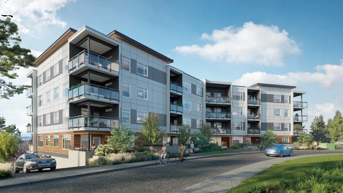
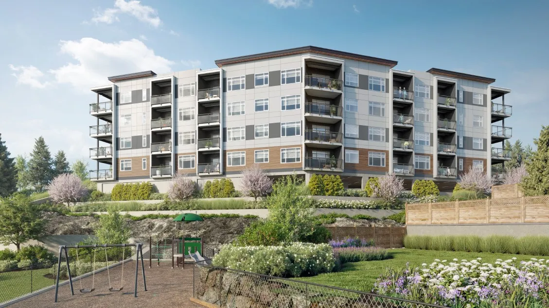
The site does not have large open spaces, and the topography requires stepping downhill to the west. The building now includes a series of roof cornice fascia projections (Figure 3) to vary the flat roofline in contrast to the hip roofs of earlier phases as shown in Figure 4 while continuing the theme of neutral colours and tones.
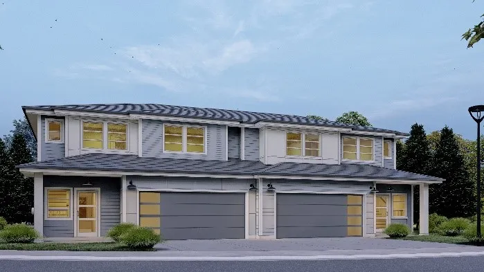
Recessed and covered balcony/outdoor space provides shelter appropriate for a rainy climate and extends the outdoor season. There is some articulation in the façade around the balconies further providing weather protection. Plans have been amended by shifting the location of a set of balconies to break up the large wall where the two wings of the building meet.
Full at-grade entrances for each unit at ground level would have been preferable; instead, more intensive landscaping has been provided for privacy from two stairwell exits from the underground parking in the front yard (Figure 2). Renderings now show the rooftop elevator extension and rooftop mechanical equipment (Figure 3). The development permit area guidelines are that the rooftop mechanical equipment be screened. This will be stated in the permit and will be addressed at the building permit stage.
Sensitive Terrestrial Ecosystems Development Permit Area (Environmental and Hazard) Approved Development Permit DP2019/02 set out environmental impact and mitigation measures including steep slope and interface fire hazard management for the comprehensive development in and will carry forward as requirements for this phase. Approved Development Permit 2020/08 allowed preclearing, blasting, and grading of this Phase 3 site with measures to:
- Protect retained trees on the periphery (and in the park)
- Address geotechnical / steep slope hazard management
- Control sediment and erosion
Interface fire hazard management requirements for the overall development were also set out in Development Permit 2019/02 and apply to this phase. These include:
- Keeping 10m low fire fuel areas between buildings and the forest edge
- Use of fire-resistant roofing and cladding materials
- Enclosed metal soffits
- Buildings are to have fire sprinkler systems
2. Zoning compliance and variances
Table 1 summarizes data for the current (Phase 4). Table 2 shows the running cumulative data for the overall development comprised of 1910/1920 Watkiss Way, Phases 1-4 of “West Park at Thetis”. Phases 5 and 6 remain to be developed in the future.
Table 1. Proposed Phase 4
| Zoning/Bylaw Requirements | Proposal | |
|---|---|---|
| Building Height | 24m, 5 storeys | 15.1m, 5 storeys |
| Site Coverage | 50% | 41% |
| Impervious Area | 50% | 59%*** |
| FSR | 1.5 | 1.4 |
| Retaining Wall height | 1.2m | 2m* |
| Retaining Wall – vertical to horizontal spacing | Min 1:1 for reinforced wall | 1:0.75* |
| Front yard setback | 6m | 5.5m** |
| Rear yard setback | 6m | 5.4m** |
| Side yard setback (south) | 4.5m | 4.1m** |
| Side yard setback (north) | 4.5m | 6.7m |
| Vehicle Parking | 60 | 60 |
| Bicycle Parking | 48 plus 6-rack at entrance | 48 plus 6-rack at entrance |
Table 2. Overall Comprehensive Development Zoning Compliance
| Section | Description – CD-23 zone | Required | Proposed |
|---|---|---|---|
| 12.23.3. | Lot Size, minimum | 4000m² | 42,580 m² |
| 12.23.3. | Total number of residential units on all lands zoned CD-23 | Max 350 | Existing: 193 + Proposed Ph. 4: 48 Total: 251 |
| 12.23.3. | Total Floor Space Ratio on all lands zoned CD-23 Total CD-23 land area: 51,930m² | 0.78:1 | Existing: 12,598m² + Proposed Ph.4: 4,852m² Floor space: 17,450m² Total CD-23 FSR: 0.34:1 |
| 12.23.3. | Floor Space Ratio on 1950 West Park Lane for Residential, Townhouse or Residential, Duplex use Lot area: 42,580m² | 0.5:1 | Existing: 7225m² + Proposed: 0m² Floor space: 7225m² Total lot FSR 0.17:1 |
| 12.23.3. | Lot Coverage, maximum | 50% (21297.6m²) | 20% (7408.92 m² + 1124m²) |
*variance required ** setback variance required to the phase boundaries; will not exist once the phase is brought into the strata. ***The impervious surface coverage (50% max. vs 59% requested) relates to the land area of the phase but is not a variance because the phase will be incorporated into the strata plan.
a. Variances for Retaining Walls The applicant requires variances for the height and spacing of retaining walls, as their heights are over the 1.2m maximum at 2m and they are stepped back less than the minimum 1:1 ratio.
4.8.10. Retaining walls must be spaced at a minimum of 1:1 height to horizontal separation ratio for reinforced walls, and a minimum of 1:2 height to horizontal separation ratio for unreinforced walls.
The proposed is a mixture of stacked boulder and concrete reinforced wall as shown in Figure 5. The stacked boulders area are terraced at the side of the building and will not be visible from the street level.
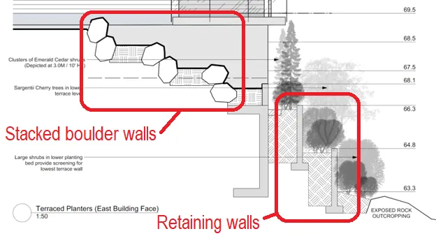
The variance to the retaining wall vertical height to horizontal spacing from 1:1 to 1:0.75 can be supported because this location is steep and because the walls will be concrete and will have shrubs that will help screen the visual extent of the wall length. A separate building permit to address the geotechnical stability of these walls will be required under the Building Bylaw because the walls are not part of the building.
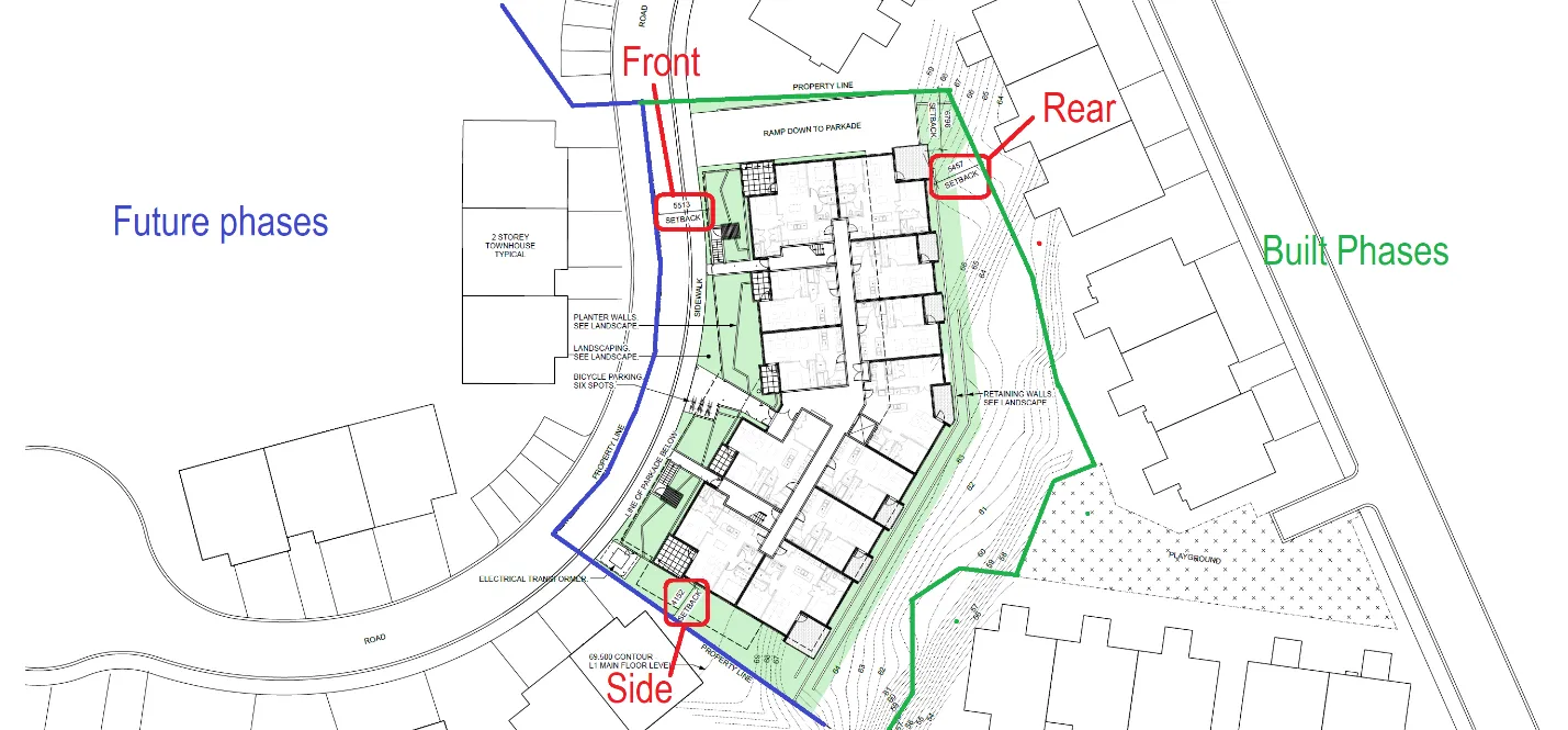
b. Variances for Setbacks The following variances relate to building siting as shown in Figure 6:
- Variance to Zoning Bylaw Section 13.23.1 front lot line setback from 6m to 5.5m
- Variance to Zoning Bylaw Section 13.23.1 rear lot line setback from 6m to 5.4m
- Variance to Zoning Bylaw Section 13.23.1 side (S) lot line setback from 4.5m to 4.1m
Phase boundaries cease to exist as each phase is completed and incorporated into a strata plan, but they are required to be treated as lot lines in the event that future phases of the comprehensive development are delayed or do not complete. These variances would not create privacy impacts on adjacent buildings and can be supported.
3. Servicing
Utility servicing
- The proposed development has been serviced with sewer, drain, hydro, and water as a condition of the creation of its parent lot. A servicing agreement is not required for the proposed development at this time.
- Prior to the issuance of the Development Permit the Applicant must confirm with the Town, through engineered calculations, that the receiving sewer and drain services and system are adequately sized for the proposed development.
- Sewer dye tests, performed by engineering staff, will be required for every new dwelling connecting to the municipal sewer system. Applicable fees will be charged at the time of each building permit application.
- Individual sewer and drain inspection chambers and water meters are recommended, but not required, at the strata’s private connection to every dwelling.
Stormwater Management
- A stormwater management plan titled “West Park at Thetis Stormwater Management Plan” prepared by Associated Engineering (AE) and dated September 2019, and the addendum to the plan by AE dated December 15, 2020, have been received and accepted by the Town.
- Per the AE stormwater management plan ongoing erosion and sediment control works will be required throughout the course of construction.
CONCLUSION
This proposal for the fourth phase of “West Park at Thetis” comprehensive development is consistent with the development concept and the guidelines of the Mixed Residential and Sensitive Terrestrial Ecosystems development permit areas. The variances to the height and spacing of retaining walls can be supported because of the rear of the site is steep; to avoid the visual impact of large blank walls, the walls are terraced and landscaped. The variances to setbacks can supported because they relate to boundaries for this phase being treated as property lines until each phase is completed the one strata plan that comprise this development. The phase is part of a comprehensive development for which infrastructure is in place at the property line with capacity to handle flows from the built-out densities entering the Towns’ sewer and storm drain systems.
RECOMMENDATION
THAT Development Permit 2021/18 be approved as per the July 14, 2022 report form the Senior Planner titled “Development Permit 2021/18 - 2000 West Park Lane (West Park One)”;
AND THAT Development Permit 2021/18 include the following variances: Development Permit 2021/08 addresses the following variances to Zoning Bylaw No. 900, 2014:
- Variance to the maximum the height of a retaining wall from 1.2m to 2m (Section 4.8.9)
- Variance to the retaining wall vertical height to horizontal spacing from 1:1 to 1:0.75 (Section 4.8.10)
- Variance to the front lot line setback from 6m to 5.5m (Section 13.23.1)
- Variance to the rear lot line setback from 6m to 5.4m (Section 13.23.1)
- Variance to the south side lot line setback from 4.5m to 4.1m (Section 13.23.1);
AND FURTHER THAT Development Permit 2021/18 include the following conditions:
- Roof top mechanical units are to be visually screened.
- Site and building exterior lighting is to be dark skies friendly.
- A security deposit for hard and soft on-site landscaping is required prior to building permit issuance.
- Environmental impacts and mitigation measures including steep slope and interface fire hazard management be implemented in accordance with Development Permits 2019/02 and 2020/10.
- The security deposit of $50,000 provided in Development Permit No 2019/02 to address any unsafe conditions or damage to the natural environment will apply to the works authorized in this development permit.
SUBMITTED BY: J. Chow, RPP, MCIP, Senior Planner
REVIEWED BY: L. Chase, RPP, MCIP, Director of Development Services
ATTACHMENTS:
- Subject Property Map
- Air Photo
- Letter to Mayor and Council – dhk Architects – November 25, 2021 (pages)
- Architectural Drawings – dhk Architects – November 2021 (15 pages)
- Landscape Drawing – LADR Landscape Architects – October 29, 2021
- Civil Engineering Drawings – Associated Engineering – November 25, 2021 (7 pages)
- Staff Review – Mixed Residential Design Guidelines (7 pages)
Document Images
(3)