Biologist’s report – Fish-KW Environmental, April 12, 2022
Environmental review of the Natural Watercourse and Shoreline Areas Development Permit Area (DPA) at the subject site.
Environmental Review for 53 Knollwood Road, Victoria, BC
Town of View Royal’s Natural Watercourse and Shoreline Areas Development Permit Area
12 April 2022
Prepared for: Jon & Echo Michiel 53 Knollwood Road, Victoria, BC V9B 1E4
Prepared by: Sara Stallard, BSc, AscT (#22338), Envr.Tech. Fish-KW Environmental 1149 Mason St, Victoria BC V8T 1A5 (250) 480-7272 sstallard@shaw.ca
Reviewed by: Lehna Malmkvist, MSc, RPBio (#1613) Swell Environmental Consulting Ltd. 480 Beach Drive, Victoria, BC V8S 2M6 (250) 217-9190
14 April 2022
Jon & Echo Michiel 53 Knollwood Road Victoria, BC V9B 1E4 via email: jon@megapower.ca
RE: Environmental Review for 53 Knollwood Road, Victoria, BC – Shoreline DPA
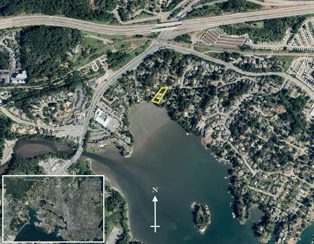
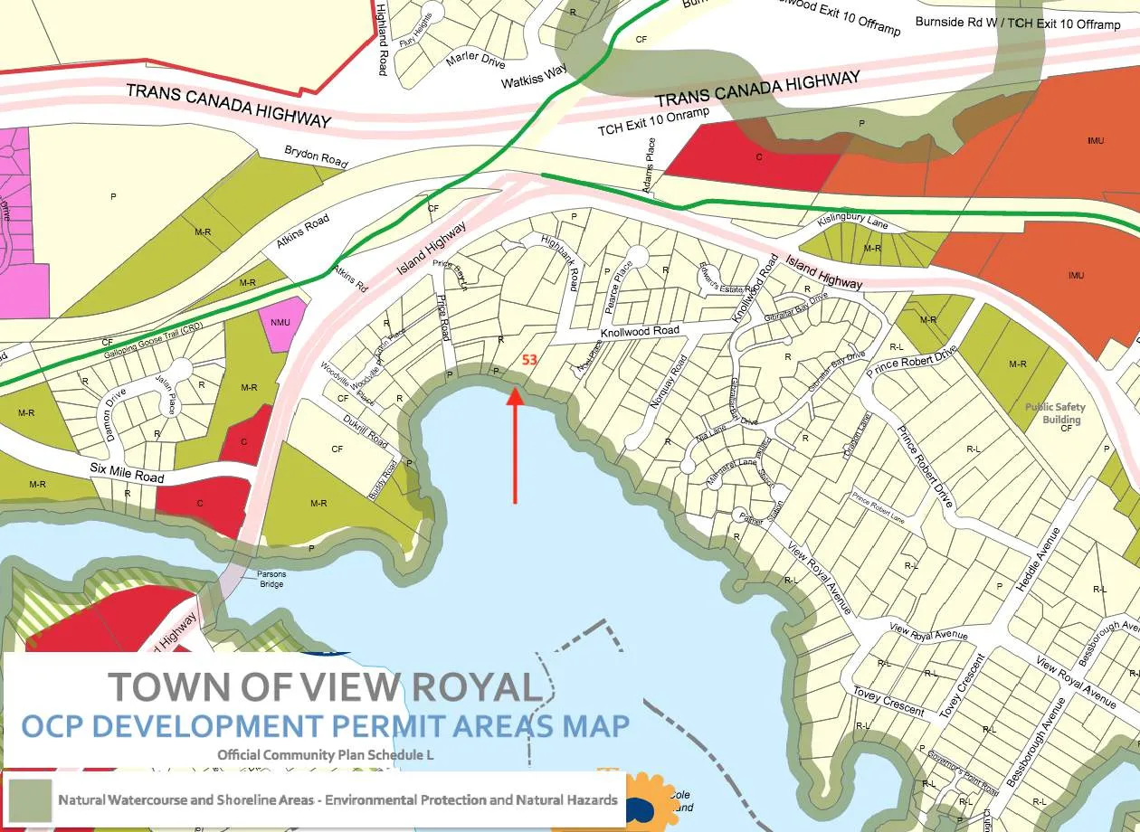
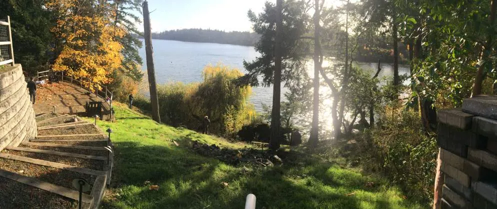
Fish-KW Environmental (Fish-KW) was engaged by Jon & Echo Michiel, owners of the property at 53 Knollwood Road, in Victoria, BC to evaluate the existing condition of the shoreline within the Town of View Royal’s Natural Watercourse and Shoreline Areas Development Permit Area (DPA) (Figures 1-4) in reference to proposed shoreline stabilisation and ecological restoration on the property¹. Multiple site visits were made between October 2021 to January 2022 to observe the current state of the site in reference to the DPA. As per View Royal’s Schedule Q of the Official Community Plan (2011) Bylaw No. 811, the site was assessed for sensitive ecosystems, red and blue listed species, wildlife trees, and all environmentally sensitive areas within the site and on the foreshore. This Environmental Review summarizes our assessment of the environmental conditions within the 15-m Natural Watercourse and Shoreline Areas DPA and potential impacts from the proposed construction and restoration work zone.
The role of Fish-KW Environmental is to assist the owner in identifying the boundaries of the DPA; evaluate the health of the ecosystems, their conservation and potential restoration requirements; communicate the benefits and importance of the ecosystems to the owner; and develop a workable balance of homeowner needs with conservation and management recommendations.
TOWN OF VIEW ROYAL GUIDELINES for NATURAL WATERCOURSE AND SHORELINE AREAS DPA
Natural Watercourse and Shoreline Areas Development Permit Area, Bylaw No. 811
According to the View Royal Official Community Plan (OCP 2011) Bylaw No. 811, the Natural Watercourse and Shoreline Areas DPA was developed for the purpose of protecting the natural environment, its ecosystems and biological diversity from development and includes all those upland and foreshore areas above and below and within 15 metres of the natural boundary of the sea.
Riparian areas and shorelines are important for their ecological value and contribution to the physical and cultural identity of View Royal. These areas support a rich diversity of flora and fauna and are integral elements of greater local and regional environmental systems. Unnecessarily disturbing these sensitive environments may harm their vitality and the ecological services they provide. This Development Permit Area has been established to ensure that the ecological values of sensitive watercourse and shoreline areas have been considered prior to development, and that measures will be taken to limit or avoid damage to these ecosystems. To the fullest extent possible all shorelines and riparian zones should be kept in a natural state and restored if they have been disturbed by development intrusions or public activity (View Royal OCP 2011).
The following Guidelines for the Natural Watercourse and Shoreline Areas DPA are applicable to the site:
General Guidelines
- Development of riparian and shoreline areas should be limited and not negatively impact the ecological health of the immediate area or impede public access.
¹ This Environmental Review relies, in part, on information provided by Ryzuk Geotechnical Engineering addressing site visits since 1996 (letter dated 16 November 2021), see Appendix 2.
- Retention of existing healthy riparian and shoreline vegetation should be maximized with any paths, structures or other constructed areas sited to minimize impact on trees and sensitive areas.
- Restoration of riparian and shoreline vegetation and habitat, including removal of invasive species, is encouraged for all properties within this Development Permit Area.
- Development should result in a net increase in native vegetation in almost all circumstances including trees, shrubs and grasses.
- For shoreline areas heavily impacted by previous development, target the restoration of ecologically appropriate vegetation for an average 15m wide (minimum 5 m) shoreline zone over 50% of the shore length.
- Riparian and shoreline area development should sensitively manage storm water, focusing on infiltration and release of storm water in ways and quantities that mimics natural patterns, avoids scouring and erosion and results in storm water free from pollutants.
- Shoreline protection measures should be limited to those necessary to prevent damage to existing structures or established uses on adjacent upland.
- In the design of new developments or re-development, the use of soft engineered and innovative alternatives to stabilizing shorelines and preventing erosion, such as bioengineering rather than traditional hard engineered measures should be used. In general, the harder the construction measure, the greater the impact on shoreline process, including sediment transport, geomorphology and biological functions. Hard" measures refer to those with solid, hard surfaces, such as concrete bulkheads, while "soft" structural measures rely on less rigid materials, such as biotechnical vegetation measures or beach enhancement. There is a range of measures varying from soft to hard that include:
- Vegetation enhancement.
- Upland drainage control.
- Biotechnical measures.
- Beach enhancement.
- Anchor trees.
- Gravel placement.
- Rock (rip rap) revetments.
- Gabions.
- Concrete groins.
- Retaining walls or bulkheads.
- Where hard measures can conclusively be shown to be the only means of effectively preventing erosion, they should be designed in consultation with a registered professional biologist, qualified environmental professionals and professional engineers, as appropriate.
- The preservation and enhancement of native trees and shrub clusters that overhang the water’s edge is strongly encouraged as these provide shade, protection and feeding habitat for fish and wildlife.
Guidelines - Specific Ocean Shoreline Types
Beach Shores may consist of broad silty/sandy beaches or gravely/blocky rubble beaches or mixed rock with beach sediment, and may be classified as either a drift-sector or pocket beach. With this type of shoreline, the following guidelines apply: i. Ensure that a minimum 15-metre setback for new buildings and structures, additions to existing buildings and structures, or the placement and removal of fill is maintained. ii. Where shore protection measures are necessary, make use of “beach nourishment” designs, which add appropriately sized material to the upper beach, creating a natural beach slope and beach armour. iii. Use of seawalls and rip rap embankments are generally not acceptable except when no alterative shore protection design is possible.
BACKGROUND INFORMATION
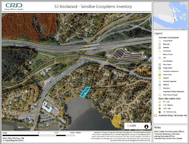
Prior to conducting the field assessment for the site, the current environmental data and information available for the area was reviewed. The CRD Natural Areas Atlas and Harbours Atlas, BC Conservation Data Centre (CDC) database, Sensitive Ecosystem Inventory (SEI) of East Vancouver Island and Gulf Islands (map sheet 92B-043), BC Fisheries Inventory Data Queries (FIDQ) and the Wildlife Tree Stewardship Program (WiTS) were reviewed for listings of environmentally sensitive ecosystems, sensitive habitat inventory mapping, rare species, red or blue-listed flora and fauna, wildlife trees, or any other pertinent environmental features.
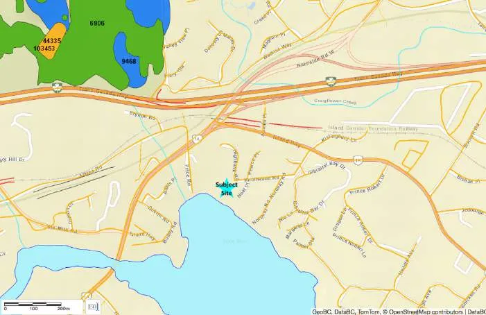
There were no environmental data points listed as occurring on this property. Five current land-based environmental data points (sensitive ecosystems and rare species) were listed within 500 m the property, all greater than 250 m distant and overlapping in some cases (Figures 5a&b). These occurrences are summarized in Appendix 1. None of these occurrences were observed on the subject site or had suitable site conditions on this existing heavily modified residential site.
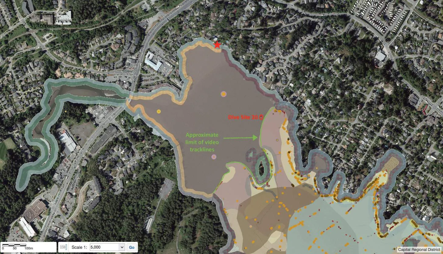
The Capital Regional District (CRD) Harbours Atlas, with data from 2000, was reviewed for intertidal and subtidal background information, supplemented with data from the original report (Archipelago Marine Resources 2004). The subject site lies in Price Bay at the very northern limit of the survey, within the extensive intertidal mudflats of the Millstream Creek Delta north of Cole Island on the northeast shoreline of Esquimalt Harbour (Figure 6). The mudflats are composed of mud and sand, and the entire bay is exposed at low tide. Marine sub- and intertidal flora and fauna (eelgrass, observed fish, other algae or invertebrates) are absent from the survey as the video tracklines do not extend into this very shallow bay. The closest dive site (~450 m southeast) observed only sand/mud with some whole shell and Graceful crab (Cancer gracilis) noted as present (ie not common or abundant). Overall Ecological Rating for the intertidal zone is Very High.
SITE ASSESSMENT
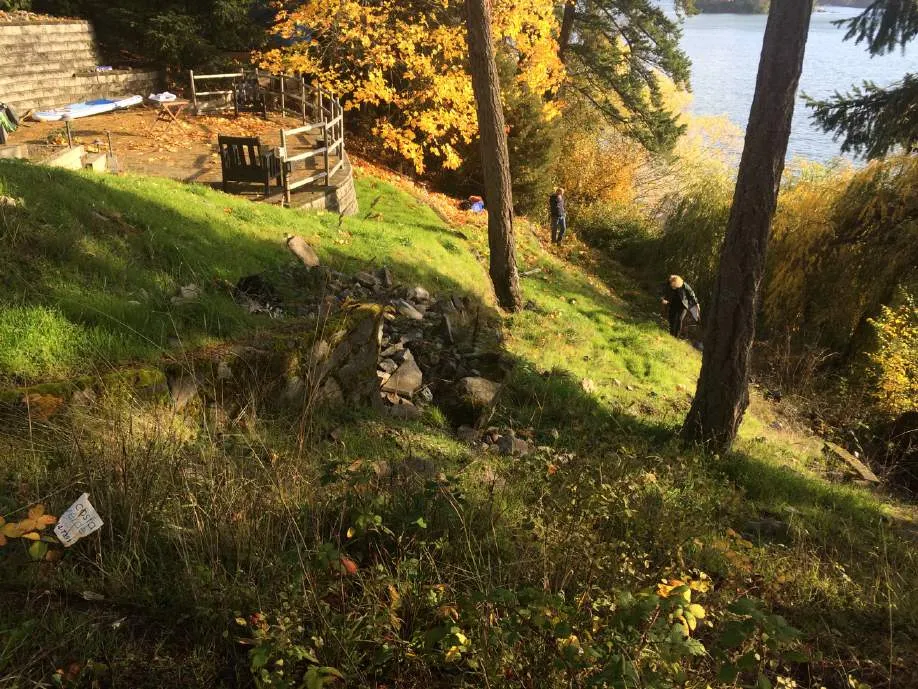
The site was visited on 7 and 26 October, 31 December 2021 and 25 January 2022 by Sara Stallard, BSc, AScT, Dipl.Env.Tech., often meeting with the current owner and contractors (Engineering and Landscaping) for the proposed project. Lehna Malmkvist, MSc, RPBio, of Swell Environmental Consulting Ltd also attended the 26 October 2021 site visit.
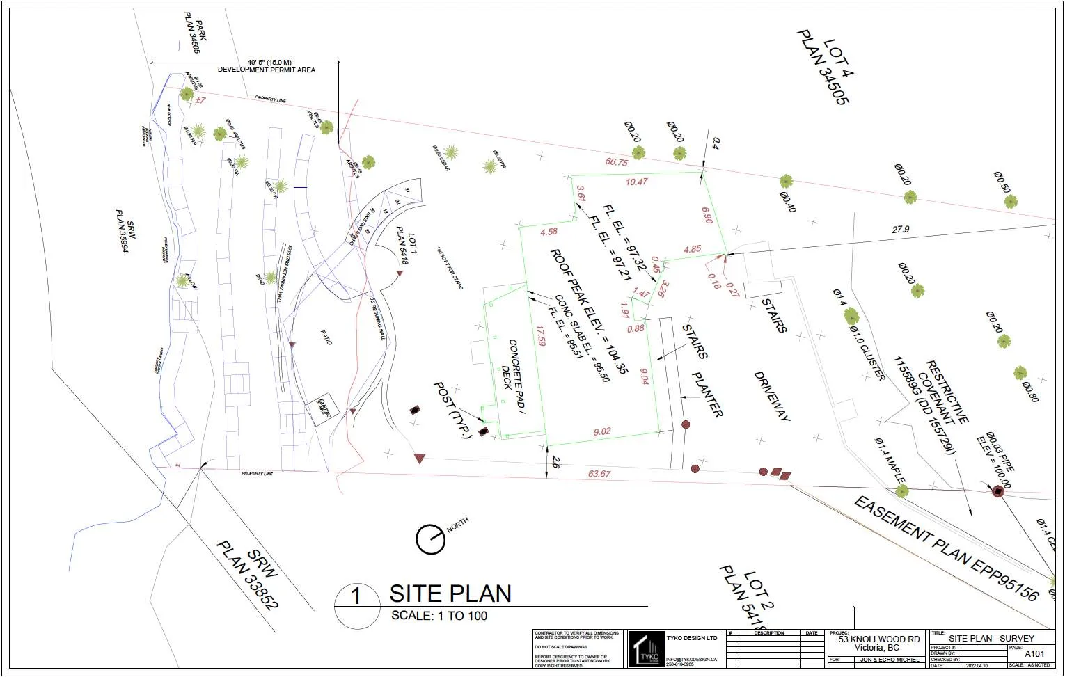
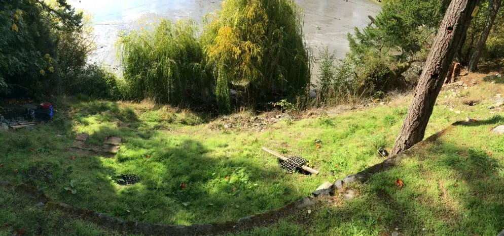
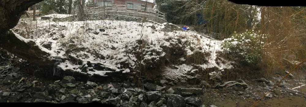
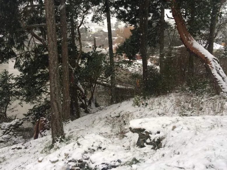
The southwestern 2/3 of this approximately 2060 m² shoreline lot has been modified by residential buildings (house and garage), driveways, patios, landscaping, and retaining walls (Photos 1-16). The steep southwest facing site slopes in a series of newer and older crumbling retaining walls to the shoreline.
Three mortared rock retaining walls were installed by previous owners prior to a significant slope failure in 1995. The history of this slope failure is summarized in a letter report by Ryzuk in Appendix 2 (dated 16 November 2021). According to Ryzuk, the retaining walls remained mostly vertical during the slope failure, although they were transported downslope approximately 2 m, along with some mature Douglas-fir trees². This full slope failure has never been fully addressed.
In 2014, the upper slope failure was partially ameliorated when a brick patio and newer Allan-block retaining wall was installed by the previous owners in consultation with Ryzuk. This is confirmed by aerial photos between 2013 and 2015 (CRD online Regional Map). Excavations in 2014 found areas of imported fill between the existing patio and Allan block wall (to remain) and the house that may have contributed to the previous (1995) slope instability of the DPA (Ryzuk).
² These mature Douglas-fir trees are the subject of an arborist report from Scotty Tree & Arborist Service dated 7 Jan 2022 in Appendix 3 and are discussed in more detail in the following sections.
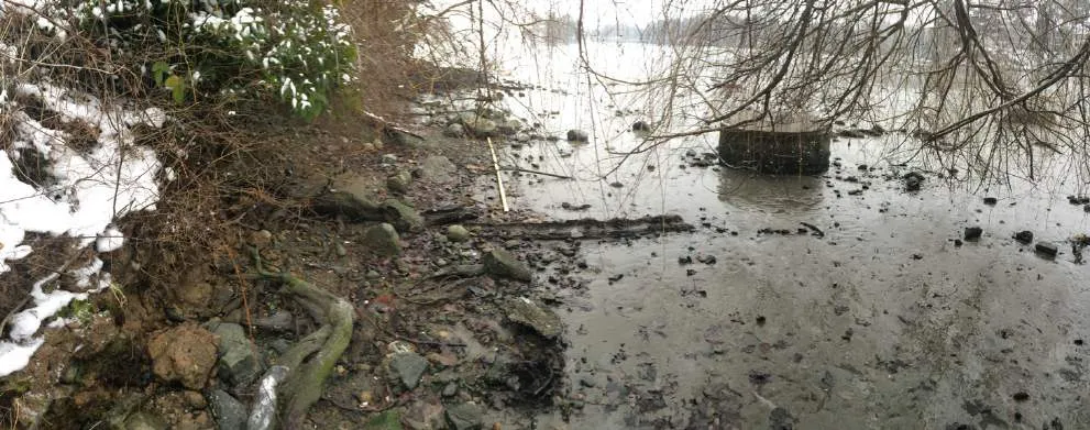
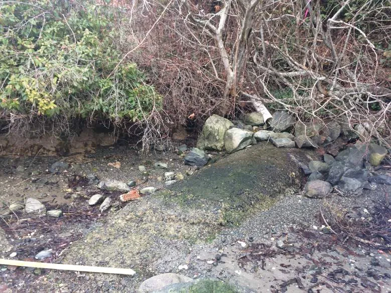
In addition to the imported fill, slope failure may have been exacerbated with leakage from a sewer lateral that extends down the slope near the eastern property line, connecting to a sewer main located on the beach at the toe of the slope (Ryzuk, Photos 9, 13). This sewer main is protected with a legal encumbrance on the shoreline below the Present Natural Boundary (PNB)(Figures 4 & 7a&b).
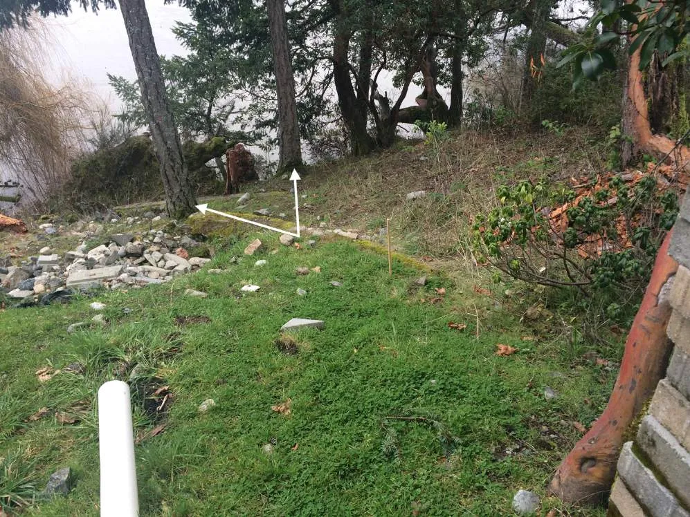
Perimeter drains are located on both the eastern and western property lines. The eastern pipe discharges at the top of the slope approximately at the DPA boundary, while the western drain is piped all the way to the foreshore and discharges onto a rock pile (Photos 3, 4, 13).
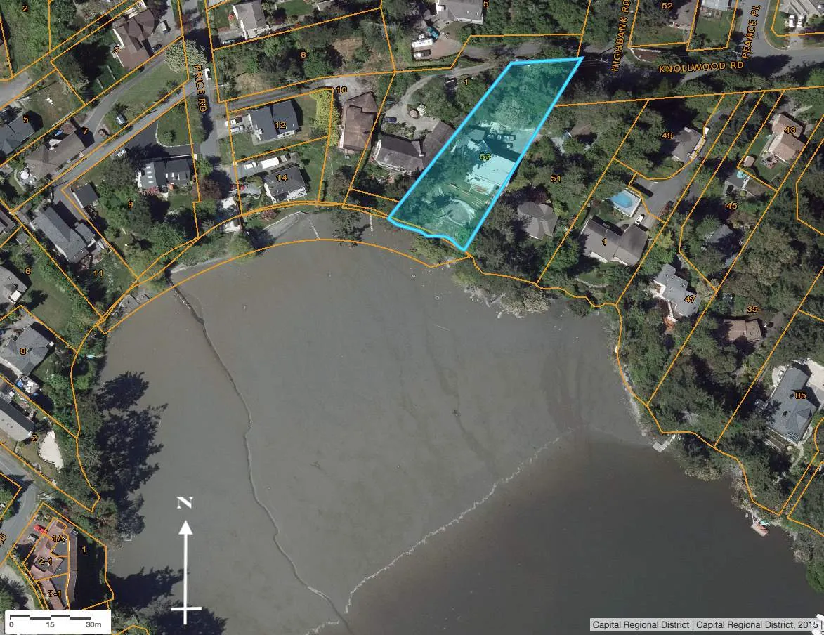
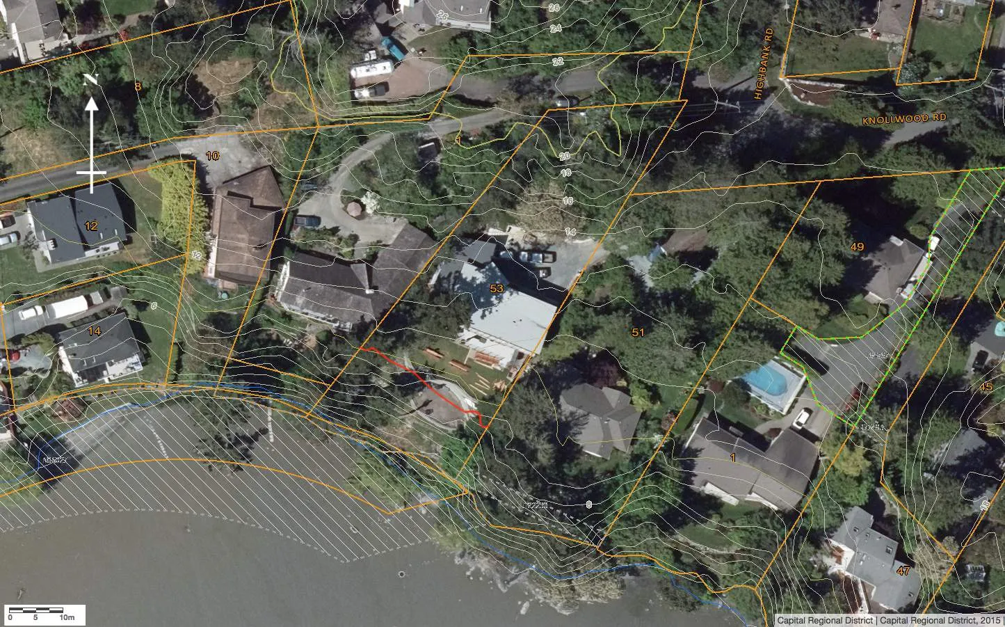
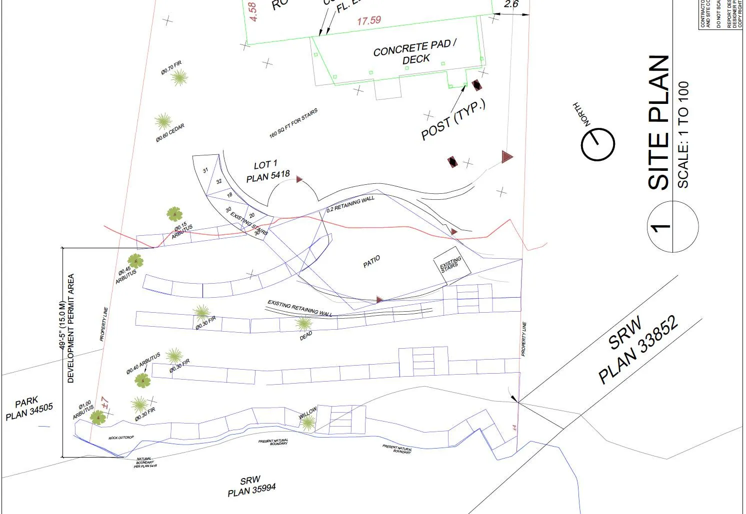
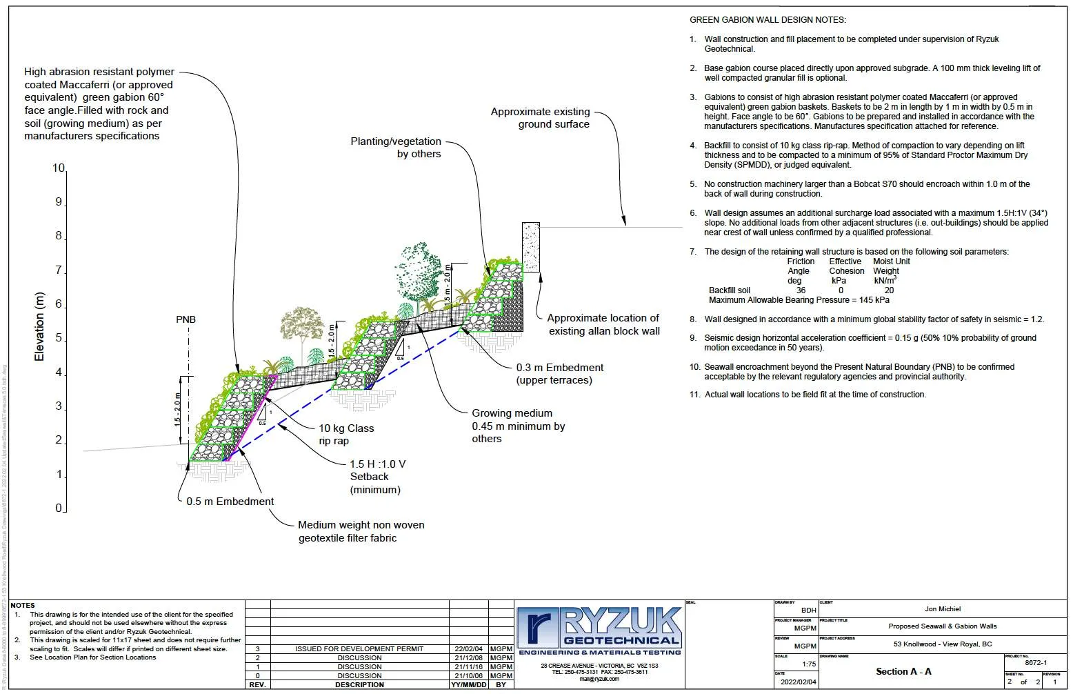
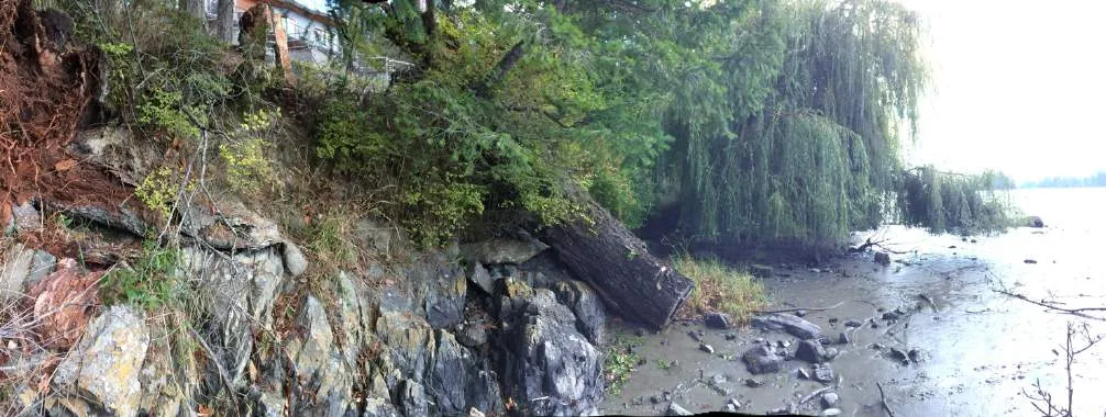
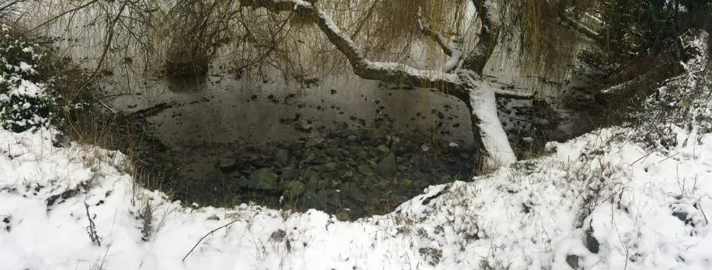
The 15-m Natural Watercourse and Shoreline Areas DPA setback includes approximately 2/3 of the backyard slope, encompassing a portion of the 2014 brick patio and newer Allan-block retaining wall on the downslope side of the patio (portion in DPA 78 m²)(Figures 4, 7-8). Below this are narrow grassy terraces supported by crumbling mortared retaining walls (constructed just prior to the 1995 slope failure). The backshore slope is approximately 8 – 10 m high from the edge of the upper back yard to the shoreline, over a horizontal distance of about 20 m (Ryzuk 2021). The slope ends in a vertical- to undercut bank of 1-2 m varying height at the shoreline of the exposed intertidal mudflats of Price Bay. Portions of exposed bedrock were observed at the western property shoreline (Photos 5, 8, 9, 13).
VEGETATION
Much of the central portion of the 15-m DPA is comprised of lawn grasses, with the remains of some ornamental and weedy species such as thistles and Himalayan blackberry (Rubus armeniacus) (Photos 1-4, 10). The fall timing of the site visits precluded a detailed list of most groundcover species. A wildlife tree (stem/trunk only) [Douglas-fir (Pseudotsuga menziesii ssp. menziesii)] in centre of the yard was leaning toward the upper slope and patio and has been removed as a hazard tree by permit from View Royal since the October site visits³ (Photos 1-2). The western and eastern property boundaries have a fringe of mature trees and shrubs, as does the shoreline edge.
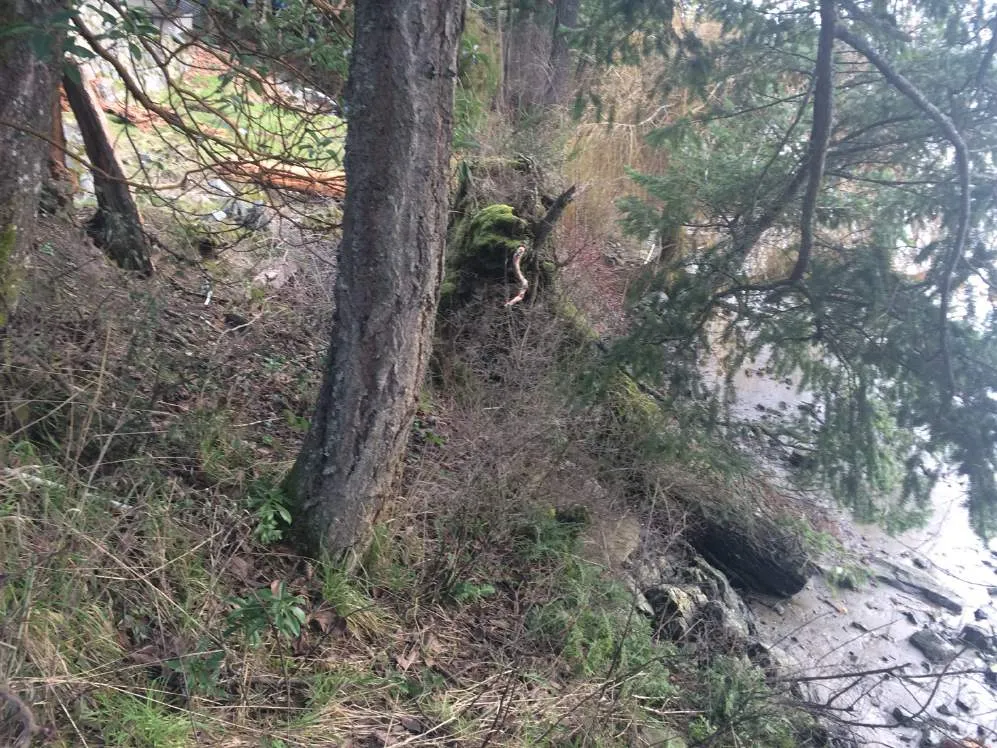
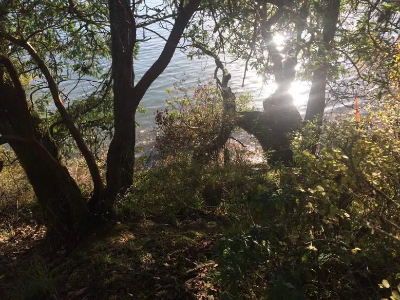
The shoreline edge is dominated by a mature willow extending horizontally over the mudflat at the centre (likely the non-native Golden willow species (Salix alba ssp. vitellina) and large arbutus trees (Arbutus menziesii) at the western edge, with juvenile Douglas-firs (Pseudotsuga menziesii ssp. menziesii), and a shrubby fringe of native willows (Salix sp.), Nootka rose (Rosa nutkana), common snowberry (Symphoricarpos albus), ocean spray (Holodiscus discolor), salal (Gaultheria shallon), and June plum (Oemleria cerasiformis), with trailing blackberry (R. ursinus), licorice fern (Polypodium glycyrrhiza), and invasive Himalayan blackberry, spurge laurel (Daphne laureola), and English ivy (Hedera helix). The remainder of the trunk of a large fallen Douglas-fir is located on the shoreline with underside of the root wad exposed on the upslope side (Photos 5-6). This shoreline vegetation overhangs the intertidal area to various extents.
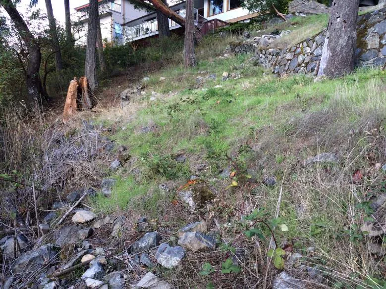
The upper property edges are fringed with juvenile and mature arbutus, Douglas-fir, grand fir (Abies grandis), bigleaf maple (Acer macrophyllum), red alder (Alnus rubra) and an unidentified conifer (juniper/cypress). The sparse understory includes salal, western trumpet honeysuckle (Lonicera ciliosa), dull Oregon-grape (Mahonia nervosa), bracken fern (Pteridium aquilinum), licorice fern, Pacific sanicle (Sanicula crassicaulis) and the invasive English holly (Ilex aquifolium), Himalayan blackberry, and spurge laurel (Photos 1-13).
A number of mature trees have been impacted by the previous slope failures and ongoing slope creep, including the horizontal golden willow, two mature Douglas-firs with fractured root plates, likely the wildlife tree and the toppled Douglas-fir on the shoreline.
³ Town of View Royal Tree Permit #2021-131.
MARINE
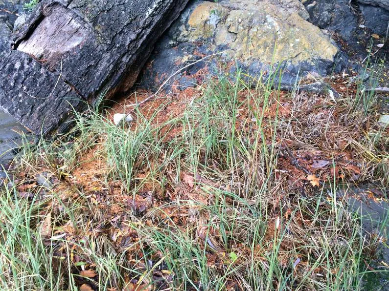
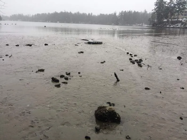
The steep shoreline sediment bluff overlies portions of exposed bedrock. Lyngby’s sedge (Carex lyngbyei) grows in scattered pockets on the mudflats at the base of the bank, mostly adjacent to the bedrock at the west end of the site (Photo 14). Non-continuous riprap is located at the base of the bank, possibly as historical shoreline armouring or as intertidal sewer line protection, which includes a cement-covered extension from the east property line and a large concrete encased manhole structure (Figure 4 & Photos 9, 13). Various debris typical of the urban marine environment is also present (tires, rusted metal, etc). The entire intertidal zone of Price Bay consists of exposed mudflats, with a greater sand component within the mud immediately adjacent to the shoreline. The intertidal survey for marine flora and fauna resulted in very few observations as the mudflat substrate is generally continuous with few scattered rocks and is too soft for foot traffic other than immediately adjacent to the shoreline.
The accessible beach, visual estimates of the remaining intertidal zone (at low tide) and the data from the Harbours Survey were used to reasonably extrapolate the composition of the remaining marine flora/fauna (Photos 9, 13-16). Detached sea lettuce (Ulva sp.), green algae (Enteromorpha sp.), brown kelp (Laminaria sp.), and red algae (Porphyra sp.) were observed, but no attached algae. No eelgrass was encountered or in any of the drift algae in the cove and because of the extensive intertidal mudflats the nearest subtidal zone for eelgrass is at least 0.5 km distant. Other than attached barnacles, no live marine fauna was observed at the immediate shoreline edge. Shells of heart cockles (Clinocardium nuttalli), littleneck clams (Protothaca staminea), varnish clams (Nuttallia obscurata), bent-nose clams (Macoma nasuta), and butter clams (Saxidomus giganteus) were observed, and it is expected that the shellfish are numerous in the extensive Price Bay mudflats. In particular, the high silt content of the nearshore beach makes this shoreline entirely unsuitable for spawning habitat of forage fish, such as Sand Lance and Surf Smelt, which require the interstitial spaces between sands and gravels for egg development.
FAUNA
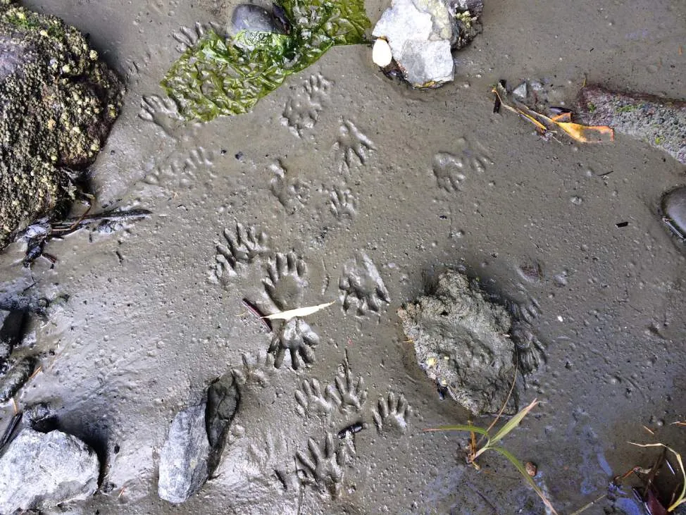
No detailed wildlife surveys were conducted; however, incidental wildlife observations on site included numerous waterfowl and Raccoon (Procyon lotor) prints in the mudflats (Photos 15 & 16). Common species such as River Otter (Lontra canadensis) and Columbia Black Tailed Deer (Odecoileous hemionus columbianus) would be expected in this area, among others. No obvious nesting activity was observed, other than previous cavities (empty) created in the wildlife tree (removed).
SURROUNDING AREA
The property is surrounded by single-family residences. The adjacent lots to the west and east are developed residential lots with similar slopes. An approximately 8 m-wide band of the shoreline property to the west is designated as a Town of View Royal municipal park (Figures 2 & 4, Photo 11).
SITE SUMMARY
The site inspections did not reveal any listed environmentally sensitive ecosystems, red or blue-listed species, or significant environmental features of this type, beyond the typical sensitivity of shoreline habitats. The single designated wildlife tree on site was leaning toward the existing structures and was removed by permit. The historically heavily impacted nature of the site, along with previous excavations and retaining structures, makes the presence of rare and uncommon species unlikely. Non-native vegetation dominates the majority of the 15-m DPA, with the exception of the slope edges and shoreline fringe. The shoreline fringe consists of mostly native trees, tall shrub species and understory, except the large horizontal non-native willow tree. Slope movement appears to have had a significant impact on many of the existing mature trees.
PROPOSED PROJECT
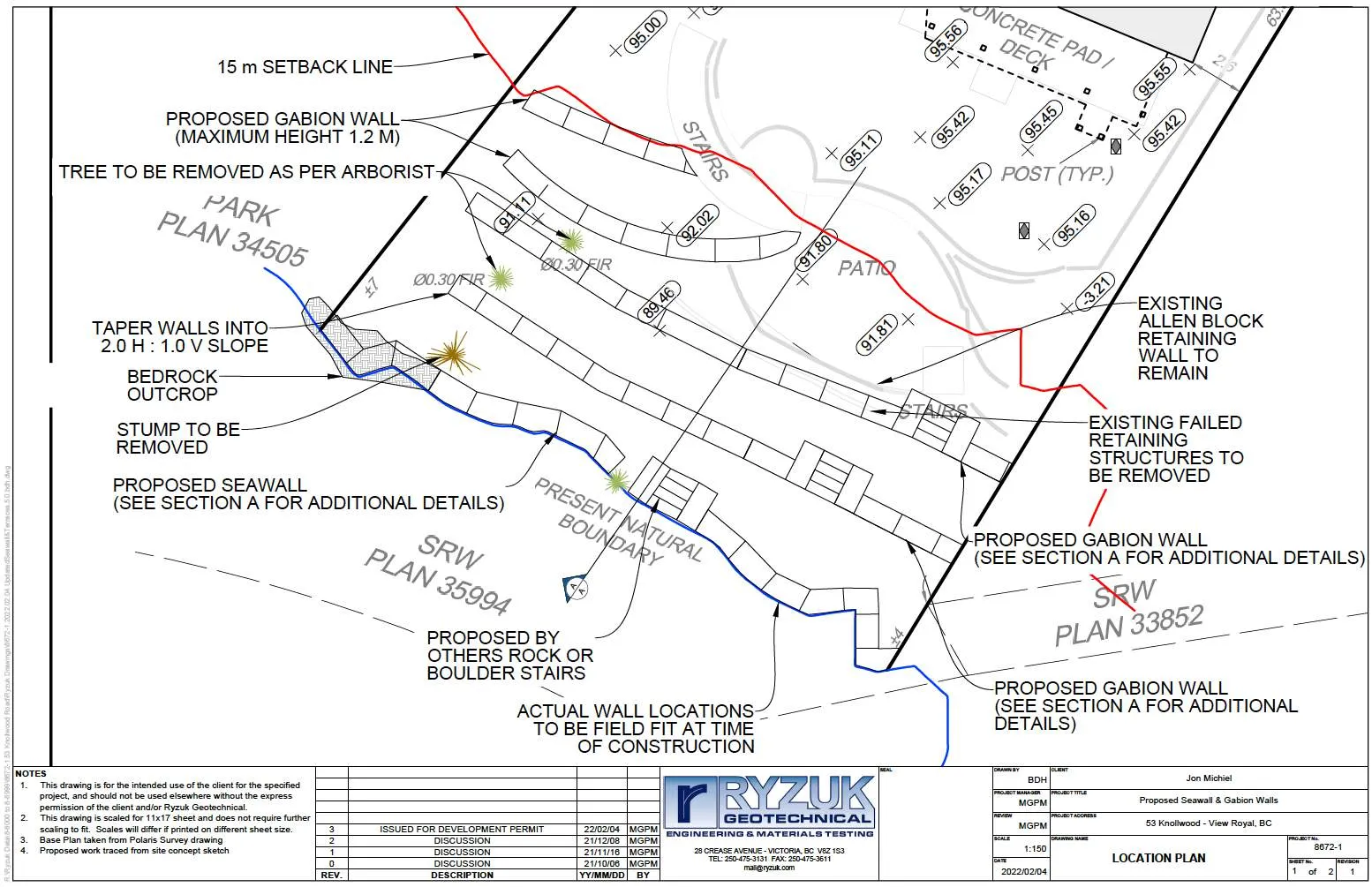
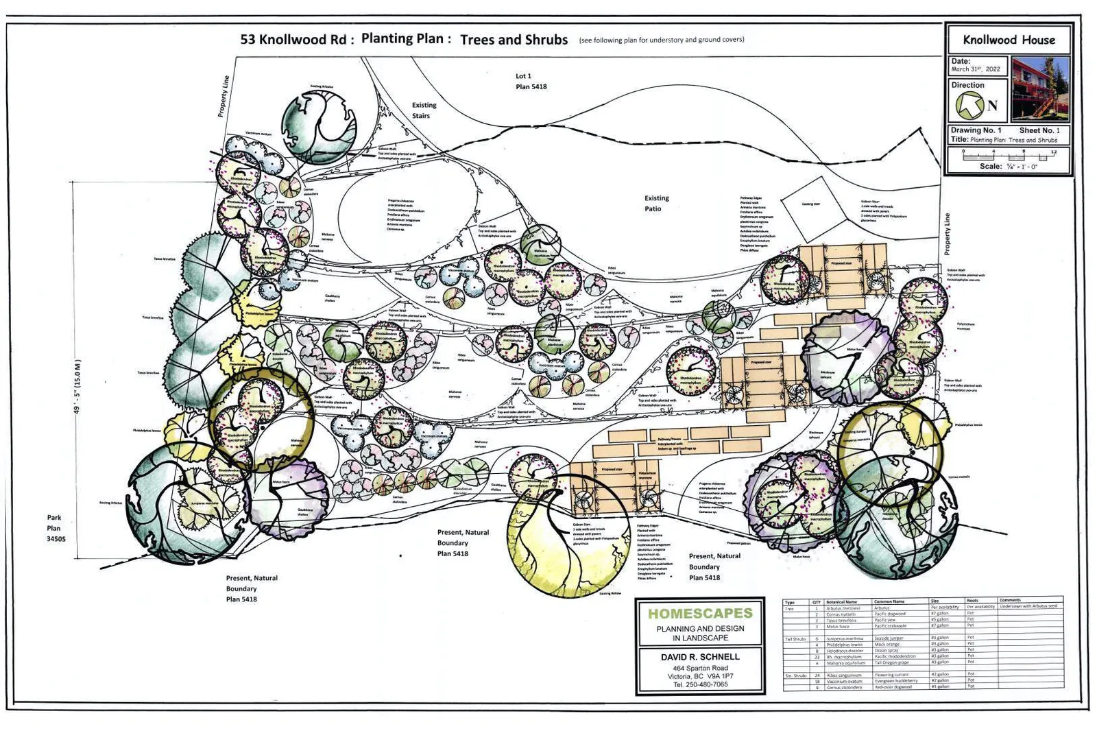
In addition to the construction of a series of vegetated gabion soil stabilization features, the owners are proposing to re-design some of the existing patios and stairs, landscaping and backyard features upslope (outside) of the DPA, between the existing patio and Allan block wall and the house. The designs outside of the DPA have not been finalised and this report addresses only the works within the Natural Watercourse and Shoreline Areas DPA (Figures 7-11 and Ryzuk Appendix 2). Within the 15-m DPA, a series of sloping and vegetated gabion walls with access steps are proposed to replace the existing lawn, ornamental and invasive vegetation, and failed retaining walls. The vegetated gabions will serve to stabilise the historical slope failures and current slope creep, remove potential imported fill that may have contributed to the previous slope instability (Ryzuk 2021), protect the existing mature trees both on the shoreline and the upland slopes to prevent the loss of more mature trees from root plate fracture, and restore approximately 85% of the DPA with all native trees, shrubs and groundcover. The perimeter drain on the east property line discharges onto a rock slab and will be re-aligned in a similar fashion. The perimeter drain on the west property line currently discharges into the upper DPA, but will be re-aligned to discharge on the bedrock portion of the shoreline.
The proposed replacement retaining structures include three rows of full site-fitted rock-filled gabion walls, starting at the PNB, to be lined with soil media to allow planting of the top and shore-facing, sloping sides with native vegetation⁴ and an additional two shorter gabions structures in the upper slope west of the existing patio and stairs (Figures 7-11). The terraces created from the gabions will be planted with a mix of native trees, tall and low shrubs, and groundcover, with an emphasis on re-creating overhanging vegetation along the shoreline for improved aquatic habitat. The landscape design, plant list, and plant densities are provided on Figures 10-11, and were developed in collaboration between the landscape designer and the biologists. The lowest wall has been designed to allow for the retention of the current mature arbutus trees (west) and the non-native willow (centre) which the owners would like to save. Although the willow is non-native, it provides habitat value such as overhanging cover and leaf-fall/insect drop to the marine ecosystem. While there are programs for removing golden willows elsewhere, the increased aquatic and shoreline habitat values represented by this overhanging mature tree outweigh the disadvantages. The shoreline and upper gabions will be field-fitted during installation to the existing areas of undulating bedrock and mature trees and tied into existing slopes at the property boundaries in order to more closely mimic the natural shoreline and site contours. The lowest gabion wall will have a relaxed slope (>60%) compared to the current undercut bank (Figures 8-9). The combination of the vegetated surface and the undulating and sloping design are expected to dissipate wave energy and reduce the commonly seen scouring impacts of older-style concrete seawalls.
The centre area of the DPA slope currently consists mainly of non-native grasses and weedy groundcover. Extensive planting with all native species across the entire slope is proposed (Figures 10-11) on and between the gabion structures. Mature trees, with the exception of two Douglas-firs designated as hazard trees by the arborist, will remain and existing native vegetation that can be salvaged will be transplanted and incorporated into the proposed planting plan. Two bylaw-protected, mature Douglas-firs (both 37 cm DBH) at the lower west edge of the slope were evaluated by Scott Mitchell (Scotty Tree & Arborist Service report dated 7 Jan 2022, Appendix 3) and are recommended for removal regardless of whether or not the shoreline stabilization proceeds:
Of particular concern is the subsiding of two Douglas Fir trees, which have shown considerable movement. One tree revealed one foot of down-slope movement, separating the root base from the surrounding soil. In both cases the root plates are cracked. This compromises the stability of the trees and presents a toppling hazard for both. Expect whole tree failures. [See marked up photos in arborist report, Appendix 3.]
⁴ Coir fibre mats or other geotextile will be used to prevent the loss of soil from the vertical faces, especially at the PNB.
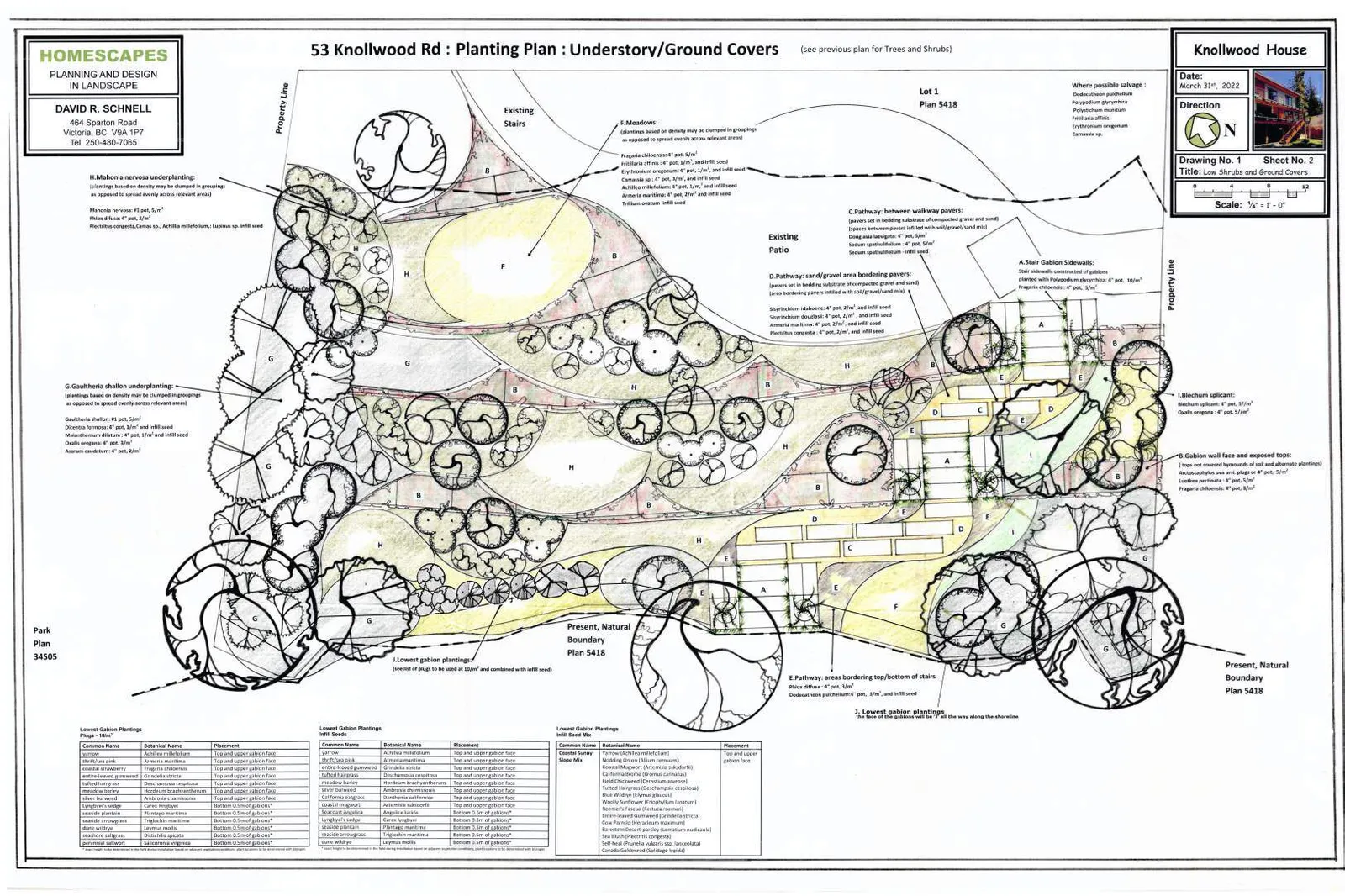
Nine trees are proposed in the planting plan, including three Pacific crabapple, three Pacific yew, two Pacific dogwoods, and one arbutus. In addition to extensive native groundcover planting, a combination of at least 96 large and medium sized native shrubs will be added to the DPA. The lowest gabion includes plugs and seeds of salt-tolerant and marine estuarine native vegetation. The patch of Lyngbye’s sedge on the west end of the shoreline will be protected during construction.
The work will be constructed during the summer Reduced Risk Fisheries Window for marine shorelines (July 1 to October 1).
The work will be conducted is such a way to minimize the impact to the shoreline and no permanent structures or land alteration are proposed below/past the PNB.
- All construction will be conducted from the landward edge of the shoreline with no equipment accessing the intertidal area. A mini 30 excavator will be used to pull back the existing slope and key in the first gabion to a depth of 0.5 m on the landward side of the PNB and material transport will be done with a T190 tracked Bobcat.
- All material will be side-cast on the landward side of the PNB and no materials will be deposited into the intertidal area.
- The dead fallen Douglas-fir trunk spanning the shoreline edge to the beach on the west edge will be cut off from the existing overturned root wad and the root wad will be removed to enable gabion construction (Photos 5 & 6). The trunk will be left to continue its function at the PNB as LWD and its final configuration (upright or horizontal in the intertidal) will depend on the field fit of the gabions at this bedrock outcrop and the capabilities of the equipment to maneuver the weight of this deadwood.
An ISA certified arborist will work with the contractor to ensure all of the tree protection measures within the report by Scotty Tree & Arborist Service are implemented during construction (Appendix 3).
POTENIAL IMPACTS OF WORK ON THE EXISTING NATURAL CONDITIONS
The project has been designed with extensive ecological considerations for the terrestrial and marine environment. The wide range of stabilization options from soft to hard engineering solutions were reviewed by Ryzuk Geotechnical, Fish-KW Environmental⁵ and the owners and the described design and restoration planting plan is the most ecologically sensitive solution to the existing failing slope, with the added benefit of re-establishing the native shoreline vegetation along this impacted shoreline.
Potential Temporary Environmental Impacts during construction include:
- Approximately 30 m² of low-growing shoreline vegetation (mix of native and non-native, invasive species) will be cleared within the DPA to accommodate the construction. The remainder of the DPA consists of grasses and weedy non-native species.
- Potential for sediment-laden runoff from the site
- Potential for spills from equipment working on site
Potential Long-term Environmental Impacts include:
- No permanent work is proposed past the present natural boundary (PNB), therefore, provided the environmental protection measures described below are implemented, no large-scale negative impacts are expected to the marine environment. The loss of some natural sediment transport or beach nourishment along this combination of sediment and rocky shoreline is not expected to impact the
⁵ Including Lehna Malmkvist of Swell Environmental Consulting Ltd.
extensive intertidal mudflats and is expected to be partially mitigated by the design of the soil layers within the rock-filled gabions, which will be fully vegetated, sloping at least 60%, and field-fitted to the existing undulating shoreline to reduce scour.
- Potential loss of one juvenile Douglas-fir⁶ at the shoreline edge if it cannot be retained or salvaged within the gabion structure (mature shoreline trees to be retained).
- The removals of two mature Douglas-fir trees (both 37 cm DBH) protected by Bylaw 695 are recommended by the arborist whether or not the shoreline stabilization proceeds. Bylaw 695 specifies two replacement trees for each tree removed. Nine trees are proposed in the planting plan, including three Pacific crabapple, three Pacific yew, two Pacific dogwoods, and one arbutus⁷. All work around the Critical Root Zone of existing trees will be done with the supervision of an ISA arborist according to the Tree Protection Plan by Scotty Tree & Arborist Service (Appendix 3).
- The total area of native plantings will increase over the existing condition and the works will include invasive species removal. Approximately 425-485 m² of native planting is proposed, roughly 85% of the DPA⁸.
- The plantings on the shoreline will provide overhanging shoreline vegetation to provide leaf fall and insect drop for food and nutrients into the marine environment, habitat for birds and small wildlife, and a protected corridor along the shoreline contiguous with the designated park area to the west⁹.
- Shoreline access for wildlife is increased through the transformation of the undercut bank to the sloping gabions.
- The retaining walls will be southwest facing and the spaces between media may provide increased habitat for reptiles.
- There will be no change to the public access to and along the foreshore.
Environmental Protection Measures including erosion and sediment control and spill prevention and response will be implemented to minimize the potential for release of deleterious substances to the marine environment. Provided that Environmental Protection Measures for construction are followed (see RECOMMENDATIONS), the project within the 15 m DPA would have no expected negative impacts and would have significant positive impacts on the existing ecological condition of the DPA backshore and foreshore, particularly for shoreline-dependent aquatic species, songbirds and other wildlife in general.
The following actions and recommendations show compliance with the Guidelines for the Natural Watercourse and Shoreline Areas DPA:
- Development of riparian and shoreline areas should be limited and not negatively impact the ecological health of the immediate area or impede public access.
⁶ The replacement trees would be covered by the current proposed planting of 9 trees. ⁷ The bylaw specifies a pot size of #5 or greater for Arbutus menziesii. The arbutus will also be under sown with prepared arbutus seed as per recommendations by local Parks Canada and Swan Lake plant specialists because of the extreme intolerance of transplanting by this species. ⁸ Areas approximate as gabions (wall areas) will be field fitted. ⁹ Vegetated coastal habitats are important breeding habitats for songbirds and they are frequently used as wintering habitats by a number of sparrow species. Shoreline trees, Douglas-firs in particular, have the potential to mature and become suitable for additional wildlife such as eagles, herons, and ospreys for nesting and perching for feeding on ocean prey including fish and waterfowl. Thick vegetation overhanging the marine environment provides an important ecological function as wildlife habitat, shading and as a food source for fish. The supralittoral (marine backshore) is an important trophic link in supplying terrestrial carbon to nearshore food webs (Romanuk and Levings 2010). The shading and protection offered by the nearshore vegetation are utilised by juvenile fish and terrestrial invertebrates are a significant food source for rearing/juvenile salmonids. Terrestrial invertebrates can make up over 50% of the stomach contents in salmonid smolts.
Development planned in the 15-m DPA includes the proposed shoreline stabilisation and ecological restoration of native coastal vegetation. The proposed slope protection works are expected to have only limited temporary impact on the shoreline and current wildlife use, provided Environmental Protection Measures regarding building materials, construction practices, and extensive replanting are followed. The increase in native vegetation throughout the DPA will provide a significant improvement on the long-term condition of the shoreline for both aquatic and terrestrial species, including fish and songbirds and wildlife in general. Fish-KW and the contractor will work together during the shore stabilisation works to ensure that native planting areas in the stabilisation works will be maximised. Public access to walk along the beach will remain unchanged.
Retention of existing healthy riparian and shoreline vegetation should be maximized with any paths, structures or other constructed areas sited to minimize impact on trees and sensitive areas. No increased development footprint (ie impervious surfaces) within the DPA is proposed, other than paving stones for the replacement pathway access to the shore within the proposed stabilisation structure. The gabion stairs and paving stone pathway will be vegetated with low-growing native vegetation simulating rocky outcrops (Figures 10-11).
Restoration of riparian and shoreline vegetation and habitat, including removal of invasive species, is encouraged for all properties within this Development Permit Area. Removal of invasive species is proposed throughout the DPA. The targeted invasive species include Himalayan blackberry, English ivy, English holly, spurge laurel, and other weedy species. The majority of the DPA impacted by the proposal consists of non-native and invasive groundcover. Coastal native vegetation removed during shore stabilisation will be salvaged where possible and augmented with extensive coastal native plantings, including significant increases in trees and shrubs (see below).
Development should result in a net increase in native vegetation in almost all circumstances including trees, shrubs and grasses. For shoreline areas heavily impacted by previous development, target the restoration of ecologically appropriate vegetation for an average 15m wide (minimum 5 m) shoreline zone over 50% of the shore length. The preservation and enhancement of native trees and shrub clusters that overhang the water’s edge is strongly encouraged as these provide shade, protection and feeding habitat for fish and wildlife. The stabilisation of this creeping slope has been designed, in part, to protect the existing mature trees both on the shoreline and the upland slopes, including Douglas-firs, arbutuses, grand fir and the golden willow (non-native), to prevent the loss of more mature trees from root plate fracture (see previous sections). Tree protection measures will be implemented for all trees on site during construction (Appendix 3). Restoration within the DPA includes the addition of 9 trees, including three Pacific crabapple, three Pacific yew, two Pacific dogwoods, and one arbutus. In addition to extensive native groundcover planting, a combination of at least 96 large and medium sized native shrubs will be added to the DPA. The lowest gabion includes plugs and seeds of salt-tolerant and marine estuarine native vegetation. The patch of Lyngbye’s sedge on the west end of the shoreline will be protected during construction. Overall, over approximately 85% of the DPA will be restored with ecologically appropriate native vegetation, particularly along the shoreline edge, significantly increasing the ecological value of the shoreline.
Riparian and shoreline area development should sensitively manage storm water, focusing on infiltration and release of storm water in ways and quantities that mimics natural patterns, avoids scouring and erosion and results in storm water free from pollutants. No increase in impervious surfaces is proposed. The perimeter drain on the east property line discharges onto a rock slab and will be re-aligned in a similar fashion. The perimeter drain on the west property line currently discharges into the upper DPA, but will be re-aligned to discharge on the bedrock portion of the shoreline.
Shoreline protection measures should be limited to those necessary to prevent damage to existing
structures or established uses on adjacent upland. The proposed shoreline protection measures have been designed to protect the existing backyard patio and stairs, mature trees and to restore the ecological function of the backshore.
In the design of new developments or re-development, the use of soft engineered and innovative alternatives to stabilizing shorelines and preventing erosion, such as bioengineering rather than traditional hard engineered measures should be used. In general, the harder the construction measure, the greater the impact on shoreline process, including sediment transport, geomorphology and biological functions. “Hard" measures refer to those with solid, hard surfaces, such as concrete bulkheads, while "soft" structural measures rely on less rigid materials, such as biotechnical vegetation measures or beach enhancement. There is a range of measures varying from soft to hard. For this project these measures have been included in the design:
- Vegetation enhancement. See above measures, including ~85% increase in native vegetation.
- Upland drainage control. See above measures, including perimeter drain re-design.
- Biotechnical measures. See below. The vegetated gabions have been developed as an integration of the biological and mechanical qualities required to stabilize this steep slope. While this list places typical gabions farther down in terms of ecological impact, this innovative design places high in the enhancement of ecological values.
- Beach enhancement. Beach enhancement is not viable on this shoreline and the addition of ‘beach nourishment’ mixes would destroy the productive biota of this section of Price Bay mudflats, including shellfish, other invertebrates and the nutrient rich biofilm that is produced on undisturbed mudflats and is a crucial food source for waterfowl.
- Anchor trees. See above measures, including protection of mature trees and addition of 9 additional native trees.
- Gravel placement. See above - beach enhancement.
- Rock (rip rap) revetments.
- Gabions.
- Concrete groins.
- Retaining walls or bulkheads.
Where hard measures can conclusively be shown to be the only means of effectively preventing erosion, they should be designed in consultation with a registered professional biologist, qualified environmental professionals and professional engineers, as appropriate. The proposed shoreline protection measure has been designed by Ryzuk Geotechnical (PEng), with input from Fish-KW (AScT) and Swell (RPBio), to address the current and continuing slope failure, replacing the existing failed retaining walls and potential imported fill that may have contributed to the previous slope instability. The proposed replacement retaining structures include site-fitted vegetated gabion walls, starting at the PNB, to be lined with soil media to allow planting of the top and shore-facing, 60% sloping sides with native vegetation. The terraces created from the gabions will also be planted with a mix of native trees, tall and low shrubs, and groundcover, with an emphasis on creating overhanging vegetation along the shoreline for improved aquatic habitat. The shoreline and upper gabions will be field-fitted during installation to the existing areas of undulating bedrock, existing mature trees and tied into existing slopes at the property boundaries in order to more closely mimic the natural shoreline and site contours. The lowest gabion wall will have a relaxed, 60% slope compared to the current undercut bank. The combination of the vegetated surface and the undulating and sloping design is expected to dissipate wave energy and reduce the commonly seen scouring impacts of older-style concrete seawalls.
The preservation and enhancement of native trees and shrub clusters that overhang the water’s edge is strongly encouraged as these provide shade, protection and feeding habitat for fish and wildlife. See above. The plantings will provide overhanging shoreline vegetation to provide leaf fall and insect drop for food and nutrients into the marine environment, habitat for birds and small wildlife, and a
protected corridor along the shoreline contiguous with the designated park area to the west.
Guidelines - Specific Ocean Shoreline Types
Beach Shores may consist of broad silty/sandy beaches or gravely/blocky rubble beaches or mixed rock with beach sediment, and may be classified as either a drift-sector or pocket beach. With this type of shoreline, the following guidelines apply: iv. Ensure that a minimum 15-metre setback for new buildings and structures, additions to existing buildings and structures, or the placement and removal of fill is maintained. No new structures are proposed in the 15-m DPA, other than the stabilisation of the slope and restoration of the native vegetation. v. Where shore protection measures are necessary, make use of “beach nourishment” designs, which add appropriately sized material to the upper beach, creating a natural beach slope and beach armour. See above - beach enhancement. vi. Use of seawalls and rip rap embankments are generally not acceptable except when no alterative shore protection design is possible. See above.
RECOMMENDATIONS for ENVIRONMENTAL PROTECTION MEASURES (EPMs) for CONSTRUCTION
The following general Environmental Protection Measures (EPMs) are recommended for work around water. Environmental Protection Measures specific to the final construction timelines, methods and materials may differ slightly.
Project Reviews will be submitted to the federal Department of Fisheries and Oceans (DFO) and to the federal Department of National Defense (DND). The following are recommended to meet the DFO requirements: Measures to Protect Fish & Fish Habitat (https://www.dfo-mpo.gc.ca/pnw-ppe/measures-mesures-eng.html):
- Maintain riparian vegetation (The golden willow tree on the shoreline will be retained, as will other native vegetation as possible; approximately 90% of the DPA will be restored with extensive native groundcover, 9 native trees, and 96 large and medium sized native shrubs.)
- Carry out works, undertakings and activities on land.
- Maintain fish passage
- Ensure proper sediment control
- Prevent entry of deleterious substances in water Additionally, any release of deleterious substances into the marine environment could be considered a harmful alteration, disruption or destruction (HADD) of fish habitat. Recommended EPMs (see below) and environmental monitoring would reduce inadvertent negative impacts to marine life.
Environmental Protection Measures During Construction
The contractor must implement environmental protection measures to ensure that the project has the minimum impact and no contaminants, such as sediment-laden water or spills, enter the marine environment.
- The work is proposed to take place within the Reduced Risk Fisheries Window for marine shorelines (July 1 to October 1).
- All of the work will be constructed from the top of slope and no work below the PNB will occur (with the exception of ESC measures below)
- Minimize tree and vegetation removal to the minimum required to construct the shoreline stabilization structures.
- Follow the ISA Certified arborist-recommendation prior to and during construction to protect retained trees during construction, including (see Appendix 3 for detail instructions):
- Arborist direction or supervision is required for excavation of the back yard.
- Remove hazardous tree #199 and adjacent Douglas-fir.
- Careful excavation is required when digging down past original grade near neighboring property lines.
- Install anti-compaction measures for access to excavation areas.
- Install protective fences that cordon off remaining property and neighboring trees.
- Remove and properly dispose of any foreign fill materials previously deposited in the DPA.
- Salvage native plants to re-use in the DPA where possible (e.g. salal, oceanspray, Nootka rose, juvenile Douglas-fir, juvenile arbutus, native willows, common snowberry, June plum, trailing blackberry, licorice fern, dull Oregon-grape, bracken fern, and western trumpet honeysuckle).
- Remove invasive species (Himalayan blackberry, English ivy, English holly, and spurge laurel) Maintenance will be required to control invasive species.
EPMs for construction are recommended as follows:
- Work will be completed during forecasted dry weather, particularly during the lower shoreline excavation and gabion installation (no work in heavy rainfall).
- Work will proceed from the upland side of the high water mark (PNB). No access for heavy equipment will occur on the shoreline.
- Exposed excavations and soil piles are to be placed away from the shoreline and covered with tarps or poly sheeting during precipitation such that sediment-laden water cannot flow into the waterbodies.
- Exposed soil will be planted as soon as possible (Fall 2022).
- Sediment fences or other measures will be installed as needed, to prevent sediment from migrating into the marine environment. A sediment fence or floating sediment curtain is suggested to contain impacts during the excavation and installation for the shoreline gabion and will be determined during construction.
- Do not direct water runoff from the site or dewatering from excavations directly into the marine environment. If dewatering of excavations is required, the Environmental Monitor must be consulted to determine where runoff can be directed.
- Existing native vegetation to be retained will be marked with highly visible flagging or snow fence and care will be taken when working around trees (as per specific arborist recommendations above).
- Ensure the materials at the work site have been secured at end of day and in rough weather.
- Ensure no tracking of sediments on to roadways from truck traffic (road sweeping and installing rock/hog fuel at entrance to minimize tracking)
- An Environmental Monitor should be present for a pre-construction site meeting, during work adjacent to the shoreline, and periodically throughout the construction period to ensure EMPs are followed.
Spill Prevention Measures will be implemented to minimize the potential for contaminants to enter the marine environment:
- Equipment will be inspected and will be power-washed/cleaned offsite prior to working adjacent to water bodies. Hydraulic fittings on equipment working near the water’s edge may require absorbent wrapping (‘diapering’ with spill pads and zip ties) if not using inherently biodegradable hydraulic fluid.
- Fuelling of any machinery or generators will occur in a designated area away from water bodies (30 m) and catchbasins. Portable generators or fuelled equipment and fuel cans should be placed in spill-proof containers sized to contain a volume greater than the fuel capacity of the equipment (e.g. plastic bin, spill trays, or impermeable containment areas such as a poly-lined bermed depression).
- Spill kits (capable of addressing the volume of fuel/oils/chemicals on site) will accompany all heavy equipment on site and operators will be trained in their use. This will include absorbent booms capable of containing leaks on the shoreline (>30 m total length).
- Ensure concrete wastes are contained (applies to work above the DPA, no concrete work within the DPA is proposed): wet concrete is not deposited into surrounding water, remove excess concrete, and do not allow water from equipment and tool cleaning to enter the environment. Any concrete pouring from the upper slope should be carefully monitored with no concrete to enter the marine environment. Wet cement is highly alkaline and can have severely adverse effects on aquatic life, including fish. Freshly poured concrete needs to be covered when rain is forecasted, or runoff needs to be isolated from waterbodies during the curing process. Cast in place concrete will not come in contact with fish-bearing waters for at least 48 hrs.
- In case of spills, the following general steps are recommended:
- Stop source of spill/prevent further spillage (turn off valves, right overturned containers)
- Block spill from reaching aquatic environment or pathways to waterbodies
- Block spill from spreading
- Call Environmental Monitors
- Clean up spilled materials
- A site run-through of spill scenarios should be discussed with the crews that will be working on site, with specific tasks assigned to personal when potential high-risk activities are planned.
Site Restoration
- Plant material must be ordered from the nursery as soon as possible to ensure it is available for the construction period (seed, plugs, and potted plants)
- Following completion of construction, implement the planting plan (Figures 10-11)
- Weed-free growing medium to be added as shown in the site plan (Figures 8-9)
- Remove and control invasive species prior to planting.
- Vegetation to be planted as per Figures 10-11. Substitutions must be approved by the QEP¹⁰
- The planted area above the intertidal area should be mulched with 10 cm composted mulch.
- Irrigation, minimum of:
- Years 1 and 2 - Watering 2/week deeply during the growing season or if plants are wilting.
- Years 3 and onwards - Water as needed to establish and wean plants off irrigation.
- Maintenance
- Invasive species removal a minimum of 4 times/growing season for a minimum of 3 growing seasons
- Temporary fencing
- Deer protection fencing may be required until the vegetation is established enough to withstand browsing (3-5 years)
- Suggested sources for native plants:
- Satinflower Nurseries (Saanich) – http://www.satinflower.ca/
- Streamside Native Plants (Bowser) – http://www.streamsidenativeplants.com/
- Premier Pacific Seeds - https://premierpacificseeds.ca/
Environmental Monitoring
Environmental monitoring is required in order to reduce the potential for inadvertent negative impacts to the environment and to ensure that environmental protection measures are properly implemented and maintained, especially during shoreline works. Environmental monitoring from the start of the project will be necessary to meet regulatory reporting requirements.
- Owner must notify Fish-KW Environmental a minimum of 4 weeks prior to the initiation of the works.
¹⁰ QEP – Qualified Environmental Professional such as Fish-KW Environmental or Swell Environmental.
- Preconstruction meeting with owner, contractor, Fish-KW Environmental, arborist and Ryzuk Geotechnical to review Project Tasks, Environmental Protection Measures and Permit Requirements.
- Site visits, periodically during key phases, as determined by the QEP, such as:
- Inspect Erosion & Sediment Control measures once they are installed
- During excavation within the 5 m shoreline area
- During initial excavation in the 15 m shoreline area
- During installation of first row of shoreline stabilization works and filling of first gabions
- During initial invasive species removal and native species planting
- During heavy rainfall (>10mm/24 hours) until the QEP is satisfied that erosion and sediment control measures are preventing sediment laden water from entering the marine environment
- Emergencies, such as spills
- To assess completion of the project
- Monitoring during construction will also consist of photos to be sent by the owner or contractor to the QEP periodically throughout the construction period to show protection of native vegetation and functioning of ESC measures. Photographs from on-site contractors during development can reduce overall monitoring costs. If needed, due to uncertainty or changes to the construction process, the QEP will schedule site visits as needed.
- Preparation of a completion report to be provided to the Town of View Royal, DFO, and DND to ensure all Development Permit, DFO and DND Project Review requirements are completed by December 31, 2022.
SUMMARY
In summary, the proposed work will not disturb any rare or endangered species or ecosystems. Provided the Environmental Protection Measures described in this review are followed, the proposed construction activities are not expected to have significant negative impacts to the current ecosystems of the 15-m DPA setback or the intertidal area of Esquimalt Harbour, or create HADD (Harmful Alteration, Disruption or Destruction) of Fish Habitat. If the restoration planting plan is implemented, the suggested restoration activities would provide significant improvement over the current conditions for this coastal bluff, in particular for aquatic species, songbirds and other wildlife.
Please do not hesitate to contact us with any questions.
Sincerely,
Sara Stallard, BSc., AscT (#22338), Envr.Tech. Fish-KW Environmental
Reviewed by: Lehna Malmkvist, MSc, RPBio (#1613) Swell Environmental Consulting Ltd.
REFERENCES
Archipelago Marine Research Ltd. 2004. Subtidal Survey of Physical and Biological Features of Esquimalt Harbour. Revised version prepared for CFB Esquimalt, Department of National Defence – Formation Environment Risk Management, Victoria, BC. Archipelago Marine Research Ltd. 2004
Green Shores for Homes. 2020. Credits and Ratings Guide. Prepared by The Stewardship Centre for British Columbia.
Romanuk, Tamara N., and Colin D. Levings. (2010). Reciprocal Subsidies and Food Web Pathways Leading to Chum Salmon Fry in a Temperate Marine-Terrestrial Ecotone. PLoS ONE, 5(4), e10073. http://doi.org/10.1371/journal.pone.0010073
Ryzuk Engineering. 2021. Proposed Retaining Walls & Pool, 53 Knollwood Road – View Royal, BC. Letter dated 6 October.
Sharp-tailed Snake Recovery Team. 2008. Recovery Strategy for the Sharp-tailed Snake (Contia tenuis) in British Columbia. Prepared for the B.C. Ministry of Environment, Victoria, BC. 27 pp.
Lowest Gabion Plantings Plugs - 10/m²
| Common Name | Botanical Name | Placement |
|---|---|---|
| yarrow | Achillea millefolium | Top and upper gabion face |
| thrift/sea pink | Armeria maritima | Top and upper gabion face |
| coastal strawberry | Fragaria chiloensis | Top and upper gabion face |
| entire-leaved gumweed | Grindelia stricta | Top and upper gabion face |
| tufted hairgrass | Deschampsia cespitosa | Top and upper gabion face |
| meadow barley | Hordeum brachyantherum | Top and upper gabion face |
| silver burweed | Ambrosia chamissonis | Top and upper gabion face |
| Lyngbye's sedge | Carex lyngbyei | Bottom 0.5m of gabions* |
| seaside arrowgrass | Triglochin maritima | Bottom 0.5m of gabions* |
| dune wildrye | Leymus mollis | Bottom 0.5m of gabions* |
| seashore saltgrass | Distichlis spicata | Bottom 0.5m of gabions* |
| perennial saltwort | Sarcocornia ambigua | Bottom 0.5m of gabions* |
Lowest Gabion Plantings 100 Seeds
| Common Name | Botanical Name | Placement |
|---|---|---|
| yarrow | Achillea millefolium | Top and upper gabion face |
| thrift/sea pink | Armeria maritima | Top and upper gabion face |
| entire-leaved gumweed | Grindelia stricta | Top and upper gabion face |
| tufted hairgrass | Deschampsia cespitosa | Top and upper gabion face |
| meadow barley | Hordeum brachyantherum | Top and upper gabion face |
| silver burweed | Ambrosia chamissonis | Top and upper gabion face |
| California Everlasting | Gnaphalium californicum | Top and upper gabion face |
| coastal mugwort | Artemisia suksdorfii | Top and upper gabion face |
| Sea-coast Angelica | Angelica lucida | Bottom 0.5m of gabions* |
| Lyngbye's sedge | Carex lyngbyei | Bottom 0.5m of gabions* |
| seaside arrowgrass | Triglochin maritima | Bottom 0.5m of gabions* |
| dune wildrye | Leymus mollis | Bottom 0.5m of gabions* |
Lowest Gabion Plantings 600 Seed Mix
| Common Name | Botanical Name | Placement |
|---|---|---|
| Coastal Seeding | Camas (Camassia leichtlinii) | Top and upper gabion face |
| Slope Mix | Nodding Onion (Allium cernuum) | Top and upper gabion face |
| Coastal Mugwort (Artemisia suksdorfii) | ||
| California Brome (Bromus carinatus) | ||
| Field Chickweed (Cerastium arvense) | ||
| Tufted Hairgrass (Deschampsia cespitosa) | ||
| Blue Wildrye (Elymus glaucus) | ||
| Woolly Sunflower (Eriophyllum lanatum) | ||
| Roemer’s Fescue (Festuca roemeri) | ||
| Prairie June Grass (Koeleria macrantha) | ||
| Gumweed (Grindelia stricta) | ||
| Low Pussytoes (Antennaria dimorpha) | ||
| Bare-stem Desert-parsley (Lomatium nudicaule) | ||
| Self-heal (Prunella vulgaris ssp. lanceolata) | ||
| Canada Goldenrod (Solidago lepida) |

APPENDIX 1. Local Environmental Data (Sensitive Ecosystems and Rare Species)
There were no environmental data points listed as occurring on this property. Five current land-based environmental data points (sensitive ecosystems and rare species) were listed within 500 m the property, all greater than 250 m distant and overlapping in some cases (Figures 5a & 5b). None of these occurrences were observed on the subject site or had suitable site conditions on this heavily modified residential site.
Rare Species occurrences:
Garry oak / California brome (Quercus garryana / Bromus carinatus) (CDC#9468)(~475 m NW of subject site) This provincially Red-listed (Endangered/Threatened) Ecological Community is listed in Thetis Lake Park and closely coincides with potential habitat for Sharp-tailed Snakes (see below). This dry, broad-leaved woodland occurrence is based on Terrestrial Ecosystem Mapping (TEM) and a field sample. This occurrence is mapped as mature and young forest and tall shrub stages. The occurrence is located within a hummocky area of Thetis Lake Regional Park and the Town of View Royal. The surrounding forest is dominated by forest, wetlands and water bodies to the north and west, by a golf course to the east, and by urban development to the south. Thetis Lake is adjacent on the west side. Highland Road passes through the occurrence and Highway 1 is located 25 m to the south. The community is associated with young and mature forest, and sparsely vegetated habitats. Terrestrial ecosystem mapping indicates that the community occurs on undulating and hummocky bedrock slopes, sometimes overlain with (thin) morainal and glaciomarine veneers. Sites tend to be well to very rapidly drained. The field sample site was an area of rolling bedrock, with shallow soil over rock, with deeper pockets (CDC iMAP). This community was not observed on this heavily modified residential site.
Rough-leaved aster (Eurybia radulina) (CDC#6906)(~475 m NW of subject site) This provincially Red-listed (Endangered/Threatened) population has not been observed since 1975 and may have been extirpated during highway construction (CDC iMAP). It is found on dry rock outcrops and open forests in the lowland zone; rare in SW BC, known only from SE Vancouver Island; S to CA (BC eFlora). The location of this listing coincides with the boundaries of the Older Forest SEI listed below. Given the extensive excavation and re-construction of the shoreline slope as a result of a 1994 slope failure, this species is highly unlikely on this heavily modified residential site.
Sharp-tailed Snake (Contia tenuis) Potential Habitat (~475 m NW of subject site and coinciding with the Garry oak / California brome occurrence described above) The Sharp-tailed Snake is a small, non-venomous, secretive animal that is a species at risk and provincially Red-listed (extirpated, endangered, facing extinction or threatened). Habitats preferred by this species are characterized by rocky talus, south-facing slopes in small forest openings, especially those in mixed Douglas-fir and arbutus ecosystems (Sharp-tailed Snake Recovery Team 2008). The subject site contains no terrain with these habitat requirements.
Sensitive Ecosystem Inventory designations: According to the SEI, “[t]hese ecosystems typically have high biodiversity and are home to many rare and endangered animals, plants and plant communities”. The SEI (Ward, et al 1998, SEI Mapsheet 92B-043) describes these rare and ecologically fragile ecosystems as follows: OF: Older Forest Ecosystems (~475 m NW of subject site and coinciding with the Rough-leaved aster occurrence described above) Older Forest ecosystems are usually conifer-dominated, occasionally deciduous, dry to moist forest types. They are generally more than 100 years, have a multi-species canopy, large woody debris - both standing and fallen - and have trees of every age. The diverse habitats found in older forests support a rich community of plant and animal species. High levels of biodiversity result from the extraordinary abundance and variety of fungi, canopy insects, soil invertebrates and lichens (many still unknown to science), all critically important parts of the forest ecosystem. Subclass OF:co (conifer-
dominated) >85% coniferous species This ecosystem community was not observed on this heavily modified residential site.
HT: Terrestrial Herbaceous Ecosystems (~250 m SE of subject site) These are non-forested ecosystems with less than 10% tree cover, generally with shallow soils and often with bedrock outcroppings. They typically occur as openings in forested areas and are vegetated with grasses and herbs and sometimes low shrubs; moss and lichen communities occur on rock outcrops. These grassy hilltops and wildflower meadows provide spectacular spring time scenes; they also provide specialized habitats, such as vernal pools and seepage zones for several rare and endangered species. Subclass HT:ro bedrock outcrops This ecosystem community and shallow bedrock topography was not observed on this heavily modified residential site.
APPENDIX 2. Ryzuk Geotechnical Report (16 November 2021)
See attached
APPENDIX 3. Scotty Tree & Arborist – Tree Impact Assessment (7 January 2022)
See attached
Document Images
(2)