OCP Review and Update – Housing Capacity Analysis and Land Use Scenarios
Urban Systems memorandum analyzing the Town's ability to meet legislated housing needs and proposing two land use scenarios.
MEMORANDUM
DATE: May 2, 2025 TO: Leanne Taylor, Director of Development Services Stirling Scory, Senior Planner FROM: Talia Mimura, Community Planner Brittany Tuttle, Community Planner FILE: 2032.0009.01 SUBJECT: OCP Review and Update – Housing Capacity Analysis and Land Use Scenarios
1.0 OVERVIEW
Amendments to the Local Government Act (LGA) in 2023/2024 require municipalities to update Official Community Plans (OCPs) and zoning bylaws by the end of 2025 to integrate 5- and 20-year housing needs accordingly. Section 473 of the LGA specifically requires an OCP to include statements and map designations outlining the approximate location, amount, type and density of residential development required to meet anticipated housing needs over a period of at least 20 years.
These housing needs are defined in the Housing Needs Assessments (HNAs) adopted by local governments since legislative changes came into effect in 2019. View Royal released the Interim Housing Needs Assessment (IHNA) in September 2024.
Urban Systems was retained by the Town of View Royal (the Town) to update the Official Community Plan which will set out the community’s land use vision for 2025. To account for the lead time required to develop and refine the OCP, View Royal is planning for growth beyond the required 20-year horizon to 2050. For simplicity, all OCP materials will henceforth refer to 20-year growth to 2050. The following memo provides an assessment of the community’s ability to meet its estimated housing need for 2050 based current and projected development trends, market conditions, and small-scale, multi-unit housing (SSMUH) provisions. Additionally, this memo provides two land use scenarios for consideration that aim to implement the vision for future growth and development in View Royal. These scenarios were prepared based on input from Town staff, initial feedback from community engagement, past direction from Council, existing market conditions and development activity, and existing land use patterns. The following memo will lay the groundwork for the development of a draft OCP that meets the legislative requirements and addresses housing needs to the year 2050.
1.1 LEGISLATIVE REQUIREMENTS FOR HOUSING
Per the legislation, the OCP must ensure that sufficient land will be designated in the OCP and zoned accordingly in the zoning bylaw to facilitate new housing development that will contribute to meeting:
- The 5-year Housing Target Order
- 5- and 20-year Housing Needs
1.1.1 Housing Target Order
On July 30, 2024, the Minister of Housing issued Ministerial Order No. M262 (Housing Target Order), under the Housing Supply Act, to British Columbia communities with the greatest housing needs¹. The Town is required to provide 585 new homes within a five-year period (from 2024-2029). The target is based on 75% of the Province’s estimated housing need in View Royal.²
1.1.2 Housing Need
The View Royal Interim Housing Needs Report (IHNR), completed in September 2024, projects a total of 842 units required over 5 years (2021 to 2026) and 2,889 over 20 years (2021 to 2041) to meet housing needs related to extreme core housing, persons experiencing homelessness, suppressed household formation, anticipated growth, rental vacancy rate adjustment, and local demand in View Royal³.
Using the 5- and 20-year housing needs calculated as part of the IHNR as a reference point, the totals of 842 units (forecasted need over 5 years from 2021 to 2026) and 2,889 units (forecasted need over 20 years from 2021 to 2041) were extended to align with the OCP time horizon of 2050. 4,189 units would be required to capture the additional growth expected between 2041 and 2050. Looking only at the span of 2041 to 2050 (10 years), 1,444.5 additional units would be required in addition to the 2,889 units required from 2021-2041 to meet the Town’s expected housing needs. These numbers are derived from reducing the 20-year total of 2,889 units to an average annual unit demand that was then multiplied out by either 10 or 29 years, as appropriate.
2.0 HOUSING CAPACITY ANALYSIS
The following section presents an analysis of housing projections for View Royal, comparing the maximum potential uptake of small-scale multi-unit housing with the projected uptake based on current zoning permissions and market conditions. It also evaluates additional anticipated residential development from current in stream development applications for residential units and additional potential development from identified test sites where higher densities than what is currently permitted were studied. Finally, these estimates are compared to View Royal’s projected housing needs for the year 2050. It is important to note that other sites not identified as part of this analysis may be viable to accommodate higher residential densities that would contribute to the Town’s housing needs.
2.1 ANALYSIS
2.1.1 Maximum SSMUH Uptake
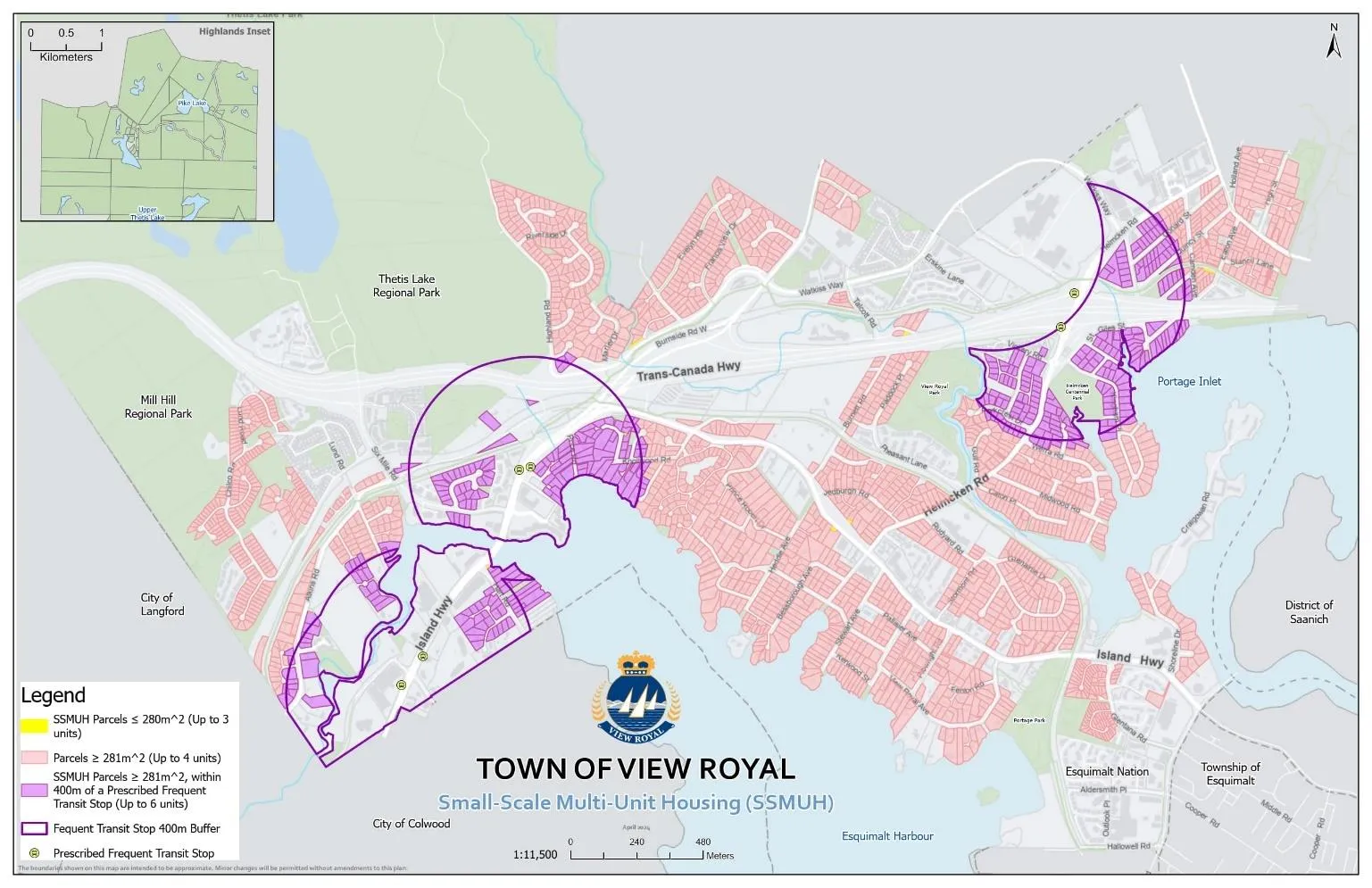
As shown in Table 1, a total of 2,127 lots in View Royal are subject to SSMUH Zoning provisions that allow up to 3-6 dwelling units per lot. If these lots were all to build out to the full zoning provisions a total of 9,255 units could be constructed. The location of these lots in the Town is shown in Figure 1. This calculation is independent of timeline, market, and other considerations.
It is unrealistic to assume that SSMUH zoning permissions will receive 100% uptake on eligible lots because:
- Existing single-detached homes would need to redevelop to accommodate 1-5 more units; and
- These lots would need to have ideal site conditions for development. This would mean an absence of topography constraints such as rock outcrops and steep slopes, along with watercourses and trees.
As such, additional analysis was undertaken to determine the potential uptake of SSMUH development in View Royal, as discussed in s. 2.1.2.
Table 1. Maximum Potential SSMUH Development in View Royal
| Total Lots | Maximum Potential Units | |
|---|---|---|
| Permit up to 3 units | 9 | 27 |
| Permit up to 4 units | 1740 | 6960 |
| Permit up to 6 units | 378 | 2268 |
| Total | 2127 | 9255 |
2.1.2 Projected SSMUH Uptake
In May 2024, the Province commissioned subject matter experts from the University of British Columbia to study the impacts of legislative changes aimed at increasing housing supply, resulting in the publication of the SSMUH and TOA Scenarios in British Columbia report (BC SSMUH Report).⁴ The BC SSMUH Report projects uptake of new housing-related zoning provisions that were implemented across the province due to legislative changes associated with SSMUH and Transit-Oriented Area requirements (Bills 44 and 47).
The BC SSMUH Report suggests that redevelopment of single-family properties will progress gradually as the industry adapts to SSMUH development and associated zoning permissions. It is anticipated that with an increased number of locations where it is profitable to redevelop single family lots, demand for this type of development will increase over time. However, at the beginning of the 10-year timespan, it is predicted that construction of multiplex development forms is low. This is due to existing labour constraints and the need for the construction industry to adapt to increased demand for these forms of housing. The study assumes that while increased costs are anticipated in the short-term when demand increases quickly before the construction industry adjusts its capacity to build new housing forms, costs will decrease over the long-term due to more efficient supply chains and more knowledgeable developers, skilled trades, and other construction professionals.
View Royal accounts for 2.78% of the Victoria CMA’s housing stock. The BC SSMUH Report forecasts a 21% to 22% net increase in residential multiplex building stock within the Victoria Census Metropolitan Area (CMA)⁵ over a 10-year timespan, based on the assumption that housing is expected to appreciate at a rate of 2% and 4% per year, respectively. In the first scenario, assuming a 2% price appreciation, an extrapolation from the BC SSMUH Report predicts a 10.5% net increase in total dwelling units (516 units) from 2024-2029 in View Royal.⁶ In a second scenario assuming a 4% price appreciation, an extrapolation from the BC SSMUH Report predicts an 11.0% net increase in total dwelling units (541 units) from 2024-2029 in View Royal. Based on the two scenarios of 2% and 4% housing price appreciation, uptake is forecasted to result in 21% - 22% net growth in total dwelling units (1,032 – 1,081 units) from 2024-2034. If this rate remains steady from 2034 to 2050, it is estimated that View Royal could experience growth of approximately 2,580-2,703 net new SSMUH units in this timeframe. This estimate is approximately 28%-29% of the maximum SSMUH build out calculated in Section 2.1.1.
Table 2. Required Number of Units to Meet Housing Need and Projected Uptake of SSMUH Permissions
| 2024-2050 | |
|---|---|
| Projected Number of Dwelling Units Required to Meet Housing Need as per IHNR | 4,189 |
| Projected Uptake of SSMUH Dwelling Units | 2,580-2,703 |
The projected uptake of SSMUH suggests that legislative changes introduced through SSMUH will not be sufficient to meet the housing needs in View Royal alone by 2050. Table 2 compares the projected SSMUH uptake of 2,580 – 2,703 units to the projected housing need of 4,189 in the year 2050. Additional action is required by the Town to create favourable conditions to permit housing and address View Royal’s forecasted housing need.
2.1.3 In Stream Residential Building Applications
As of March 2025, a total of approximately, 548 new dwelling units are expected to be completed within the next 2 years. Partial occupancy was granted for a total of 178 new dwelling units for two multi-unit buildings in June and July 2024. Two multi-unit buildings totalling 158 dwelling units are partially occupied as of February 2025. These 884 units will contribute to the Town meeting its short-term housing need of 842 units by 2027.
2.1.4 Test Scenarios
The 2025 Land Economics Study completed by Urban Systems evaluates the development viability of different mixed-use development scenarios and updates the 2021 study completed by Coriolis Consulting titled Land Economics Study: Evaluation of the Prospects for New Urban Development (Coriolis Study). Table 3 projects the number of dwelling units from viable test sites identified in these studies. The study from Coriolis identified seven viable test sites for multi-unit residential development and the study from Urban Systems identified one additional viable site for mixed-use development with retail and residential. The location of these test sites is shown in Figures 2 and 3.
Viable sites have residual land values from development that are equal to or greater than the ‘as-is’ land value. To calculate the number of units at each test site, an average gross unit size of 1,000 square feet was used. The building efficiency ratio for the test sites provided in the Coriolis Study are unknown, therefore the number of units provided in Table 3 may not account for usable square footage, potentially resulting in less units. The total number of dwelling units projected is approximately 2,238 if actual development aligns with the densities proposed in the test sites. It is important to note that allowable density permissions in the land use designations and subsequent zoning, along with future market conditions could yield a higher or lower number of dwelling units.
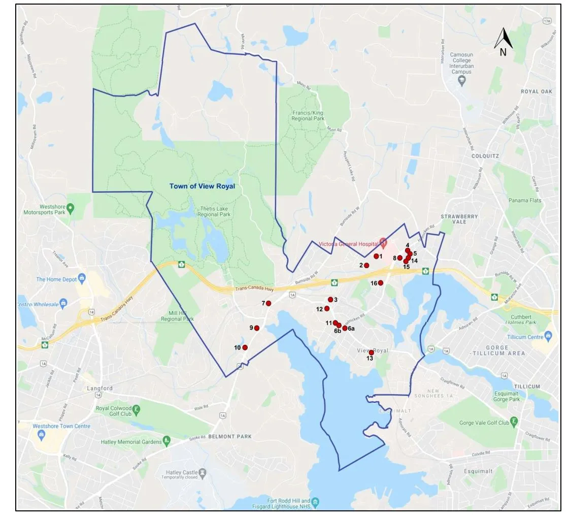
Table 3. Number of Units Projected from Test Sites
| Test Site | Neighbourhood and Road | Site Size (SF) | Structure Description | Current OCP Land Use Designation | Test FSR | Height (Storeys) | GFA (SF) | Est. No. of Units | |
|---|---|---|---|---|---|---|---|---|---|
| USL Study (2025) | 1a | Atkins Neighbourhood, Atkins Rd | 35,225 | Standard House | M-R Mixed Residential | 2.5 | 6 | 588,063 | 588 |
| Coriolis Study (2021) | 1 | Hospital Neighbourhood, Hospital Way | 299,518 | Vacant | IMU Intensive Mixed Use | 2.5 | 5 | 1,048,313 | 1048⁷ |
| 2 | Hospital Neighbourhood, Erskine Lane | 47,262 | Old single-family home | Intensive Mixed Use | 2.5 | 5 | 165,417 | 165⁷ | |
| 6b | Harbour Neighbourhood, Island Hwy | 38,261 | Older Commercial | Neighbourhood Mixed Use | 1.6 | 4 | 57,392 | 57 | |
| 8 | Hospital Neighbourhood, Chancellor Ave | 34,848 | 3 Old SFDs | Neighbourhood Mixed Use | 1.5 | 4 | 52,272 | 52 | |
| 11 | Harbour Neighbourhood, Island Hwy | 46,609 | 3 Old SFDs | Mixed Residential | 1.6 | 4 | 69,914 | 70 | |
| 12 | Harbour Neighbourhood, Island Hwy | 130,680 | Duplex, Rental | Mixed Residential | 1.6 | 4 | 196,020 | 196 | |
| 13 | Harbour Neighbourhood, Island Hwy | 40,510 | 1 Old SFD and Rental Townhouses | Mixed Residential | 1.6 | 4 | 60,765 | 61 |
⁷ The Coriolis Study determined the viability of development based on existing allowable FSR of 2.5. However, new provincial legislation requires a minimum density of 3.5 FSR and 10 storeys for lands within the TOA, which include Test Sites 1 and 2.
2.2 TRANSIT ORIENTED AREA (TOA)
View Royal is subject to the Housing Statues (Transit-Oriented Areas) Amendment Act⁸ (Bill 47) due to the existence of a prescribed transit station adjacent to the Victoria General Hospital (Figure 4). The legislation establishes minimum densities that must be allowed in relation to land zoned for any residential (or other prescribed) use in the TOAs (Table 4).
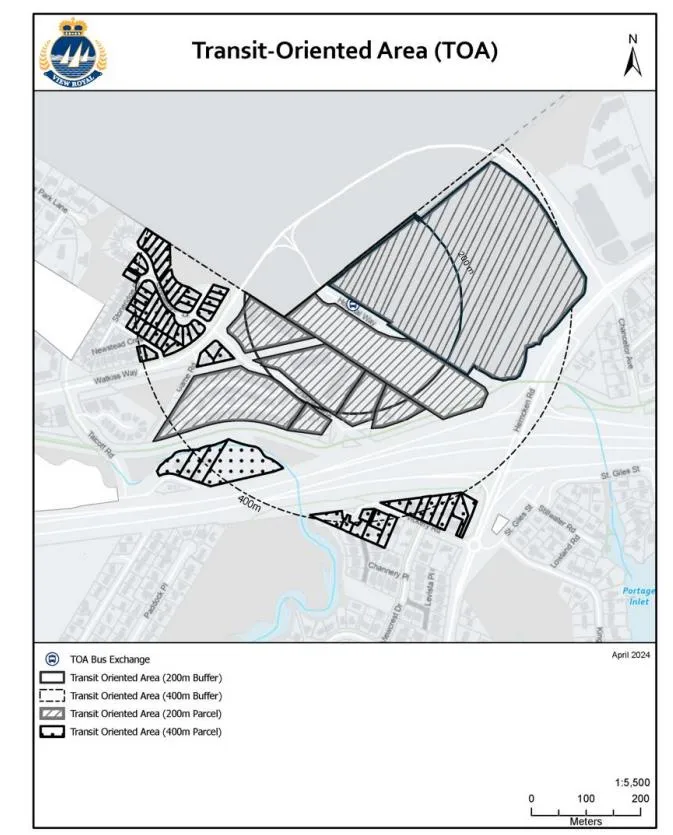
Table 4. Transit-Oriented Area Legislation for View Royal¹⁰
| Transit Hub Type | Prescribed Distance | Minimum Allowable Density (FAR) | Minimum Allowable Height (Storeys) |
|---|---|---|---|
| Prescribed Bus Exchange | 200m or less | Up to 3.5 | Up to 10 |
| 201m – 400m | Up to 2.5 | Up to 6 |
2.3 RESULTS
Based on the projected uptake of SSMUH development in View Royal, housing developments currently under construction, and the selection of test scenarios from the land economics studies, it is estimated that approximately 5,366 new dwelling units will be constructed in View Royal over the next 25 years (Table 5). The total number of dwelling units is subject to change as market and political conditions may fluctuate over the lifespan of the OCP. To put this into perspective, Section 1.1.2 highlights that a total of 4,189 dwelling units will be required over the same period to meet the Town’s overall housing demand. Based on current conditions, projected SSMUH uptake, and a selection of test scenarios with high development potential with higher permitted density than current OCP/Zoning provisions, View Royal has enough land to meet its projected housing needs (see Table 5 below). However, it is important to note that these numbers are subject to fluctuations based on evolving market conditions, policy decisions, global economic changes, and unforeseen circumstances that could impact housing needs and development trends. Additionally, considering additional density beyond the projections indicated in Table 5 is crucial to support the community’s desired increase of services and amenities.
Table 5. Analysis of Housing Needs versus Anticipated Housing Development
| Number of Units | |
|---|---|
| Projected SSMUH Uptake (to 2050) | 2,580 |
| Development In-Stream (at the time of March 2025) | 548 |
| Viable Test Scenarios | 2,238 |
| Total Potential Housing Development | 5,366 |
| 25-Year Housing Need | 4,189 |
3.0 COMMUNITY ENGAGEMENT
3.1 KEY FEEDBACK FROM COMMUNITY ENGAGEMENT
The Town facilitated two rounds of community engagement between January and early April 2025. The first round of engagement focused on community visioning for the lifespan of the OCP. A visioning survey was available for the public to engage with from late January to mid-February. The second round of engagement focused on understanding community’s perspectives related to land use, housing, and growth. The Town facilitated an online survey, open houses, and workshops throughout the month of March and into early April to seek community input on these topics.
Key themes that emerged from the first phase of engagement on community visioning that were considered when drafting the land use scenarios discussed in Section 4 include:
- Parks, Trails, and Greenspaces: Preserving and expanding parks, trails, and greenspaces was deemed essential for maintaining the quality of life and natural beauty of View Royal.
- Commercial Services and Mixed-Use Developments: There is a strong desire for more mixed-use developments that integrate commercial and residential spaces and provide more commercial services and amenities.
- Improved Transportation Connections: Enhancing transportation links throughout View Royal, including better connectivity and public transit options, was a top priority for many respondents.
- Community Spaces: The community expressed a need for more public spaces where events and gatherings can be held, strengthening the sense of community.
- Walkable Neighbourhoods: Creating walkable neighbourhoods with essential services and amenities was an important consideration for residents.
Further insights were learned during the second round of engagement on community preferences related to growth and development which were valuable considerations for the land use scenarios. Some of these preferences include:
- Strong support for expanding existing Neighbourhood Centres to include higher density residential and mixed-use development.
- Hospital Neighbourhood Centre (78%), Atkins Neighbourhood Centre (70%), Lakeside Village Neighbourhood Centre (62%), Burnside Corner Neighbourhood Centre (59%),
- Strong support for expanding existing Community Corridors to support transit use and transit-oriented development.
- Western Gateway Community Corridor (83%), Eastern Gateway Community Corridor (82%), Northern Gateway Community Corridor (76%), Helmcken-Harbour Community Corridor (61%)
- Most participants supported developing a Town Centre in View Royal, with the majority supporting the location of this at the Fort Victoria RV Park site.
- 63% of survey respondents support a Town Centre concept and 52% support the location of a Town Centre at the Fort Victoria RV Park site
- Participants indicated preferences for desirable businesses and services in mixed-use developments as restaurants or cafés (87%), health services (82%), grocery stores (64%), services (hair salons, banks, post office, professional offices, etc.) (61%), and community services (libraries, government offices, etc.) (58%)
- Further, respondents identified the types of land uses they would like to see in the Western Gateway Community Corridor as mixed-use development with commercial, light industrial, and some residential uses (51%), only commercial and light industrial uses (18%), only residential development (10%)
- Support for building heights in existing Neighbourhood Centres:
- Hospital Neighbourhood Centre (82%), Atkins Neighbourhood Centre (76%), Lakeside Village Neighbourhood Centre (68%), Burnside Corner Neighbourhood Centre (64%)
- Support for building heights in existing Community Corridors:
- Western Gateway Community Corridor (78%), Eastern Gateway Community Corridor (77%), Northern Gateway Community Corridor (73%), Helmcken-Harbour Community Corridor (61%)
4.0 LAND USE SCENARIOS
Two land use scenarios were crafted for the Town’s consideration as part of this OCP update. Following community and Council input, one scenario will be crafted to guide land use and development in View Royal to the year 2050. The two land use scenarios described in this section aim to balance the following:
- Market conditions and economic viability;
- Community vision and aspirations for future growth and development;
- Legislative requirements and the Town’s existing plans and policies; and
- Infrastructure servicing capacity, with consideration to existing capacity, anticipated upgrades, and what is possible for expanding the level of service provided by the Town.
It is important that these considerations be given equal weight when formulating land use scenarios to ensure that the Town can attract the type of development it would like to see within the lifespan of the OCP. In absence of this, land may remain vacant due to high costs of development and little opportunity for profit generation. Increased densities are therefore key to achieving a balance of the aforementioned factors, as they allow for:
- Greater revenues to be generated from the sale or lease of more units / floor area, increasing the viability of development for the land owner;
- Increased population and need for community amenities and services (e.g. parks, community gathering spaces, retail, restaurants, etc.), which in turn increases the viability of providing these desirable uses; and
- Increased tax revenue for the Town, lowering the cost of providing community amenities and services for residents and property owners.
As discussed in section 3.2, the community demonstrated support for diversifying land use within existing neighbourhood villages and along corridors to provide more community amenities and housing options. Current market conditions indicate that mixed-use commercial-residential developments must be at least 6 storeys in height to be feasible¹¹. This plays a key role in influencing how View Royal can grow in a way that supports the community’s desires for its village and corridor growth areas and was a primary consideration in formulation of the two land use scenarios discussed in this section.
The two land use scenarios are presented as follows:
- Section 4.1 provides an overview of the land use designations associated with each of the land use scenarios. This includes a description of the intent for the designation and the maximum densities that may be supported.
- Section 4.2 highlights the similarities that exist between the two scenarios, with:
- Section 4.2.1 discussing the key aspects of Scenario 1, and;
- Section 4.2.2 discussing the key aspects of Scenario 2.
4.1 PROPOSED LAND USE DESIGNATIONS
Table 6 below discusses the land use designations proposed for each of the scenarios discussed in Section 4.2. In review of these land use designations, it is important to consider that any development six storeys or above may be subject to the provision of amenity contributions. This would be applicable to development that occurs within the Urban Centre, Western Gateway Employment District Corridor, Corridor, Neighbourhood Village, and Multiple-Unit Residential land use designations. Provisions for amenity contributions will be addressed in the accordingly policy sections of the new OCP.
Table 6. Proposed Land Use Designations.
| Proposed Designation | Description | Maximum Height/Density |
|---|---|---|
| Urban Centre | Development located within a central area of the community, serviced by frequent transit that serves as future mobility hubs. Community and commercial services and amenities are provided to serve the broader View Royal community and neighbouring jurisdictions, in addition to high-density building forms. This may include mixed-use development with apartments, visitor accommodations, restaurants, retail, office spaces, and civic uses (e.g. daycares, libraries, public gathering and amenity spaces). | Up to 10 storeys* FSR max 3.5* |
| Hospital Transit-Oriented Area | Lands provincially designated as Transit-Oriented Development Area comprising the Victoria General Hospital and immediately adjacent properties. This area is serviced by the Hospital Transit Exchange providing frequent bus service and allows for medium- to high-density building forms. This may include mixed-use development with apartments, visitor accommodations, restaurants, retail, office spaces, institutional uses (i.e. hospital) and civic uses (e.g. daycares, libraries, public gathering and amenity spaces). | Up to 15 storeys FSR max 4.0 |
| Western Gateway Employment District Corridor | Lands located along the Western Gateway portion of Island Hwy between the Parsons bridge and City of Colwood boundary. This corridor is a major transportation route that serves regional and visitor needs through predominantly employment uses supported with residential. Buildings may be a mix of medium- and high-building forms. This may include, but is not limited to ground-floor commercial space in the form of retail and restaurants, visitor accommodations, artist studios, offices, distribution and repair, light manufacturing and processing, and institutional uses such as arts, innovation, and technology. Mixed-use buildings with employment and residential uses may be permitted. | Scenario #1: Up to 10 storeys FSR max 3.5* Bonus densities up to 15 storeys (up to 4.0 FSR) may be supported with provision of community amenities (e.g. park, daycare, community hall, courtyard, etc.) and additional floor space dedicated to employment land uses. Scenario #2: Up to 6 storeys FSR max 2.5 |
| General Employment | Development comprising of primarily employment-generating uses and accessory mixed-uses, such as light industrial manufacturing and processing, warehousing, professional offices, and service commercial uses. Buildings may be range of low- to medium-rise building forms, including those with large floor plates on lots with space suitable for vehicle circulation, shipping, and delivery. | Up to 6 storeys FSR max 2.5 |
| Corridor | Lands located along key transportation routes that serve local needs through a mix of residential and employment land uses. Buildings may be a mix of low- and medium-building forms. This may include, but is not limited to small shopping centres, service commercial uses, visitor accommodations, and mixed use apartments with ground-floor retail, restaurants, artist or live-work studios, and offices. | Up to 6 storeys FSR max 2.5 |
| Neighbourhood Village | Areas allowing for small-scale, mixed-use development that serve local neighbourhood needs. These areas encourage walkability through providing multi-unit housing forms and community-serving commercial and civic uses. This may include schools, offices, restaurants, retail, small grocery store and community spaces. | Up to 6 storeys FSR max 2.5 |
| Multiple Unit Residential | Residential areas allowing for low to medium-building forms, including apartments, townhouses, house-plexes, and community care facilities. | Up to 6 storeys |
| Ground-Oriented Residential | Residential areas consisting of rowhouses, townhouses, and house-plexes that are accessed via separate entrances at the ground-level. | Up to 3 storeys Min. 3 units |
| Small-Scale Multi-Unit Housing | Consists of detached and attached dwellings forms, including duplexes, secondary suites / garden suites, rowhouses, townhouses, and house-plex | Up to 3 storeys |
| Parks and Open Space | Active and passive parks, trails, natural spaces, and outdoor recreation facilities. | N/A |
| Institutional | Government buildings and publicly-owned facilities providing a range of services, amenities, and utilities for the community including health care facilities, emergency service buildings, community halls, libraries, treatment plants / facilities, and schools. | Varies |
| Rural | Lands allowing for large lot residential uses, including small-scale farming. | N/A |
| Urban Reserve | Land to be transferred to a First Nation community within the lifespan of this OCP. | N/A |
4.2 PROPOSED LAND USE SCENARIOS
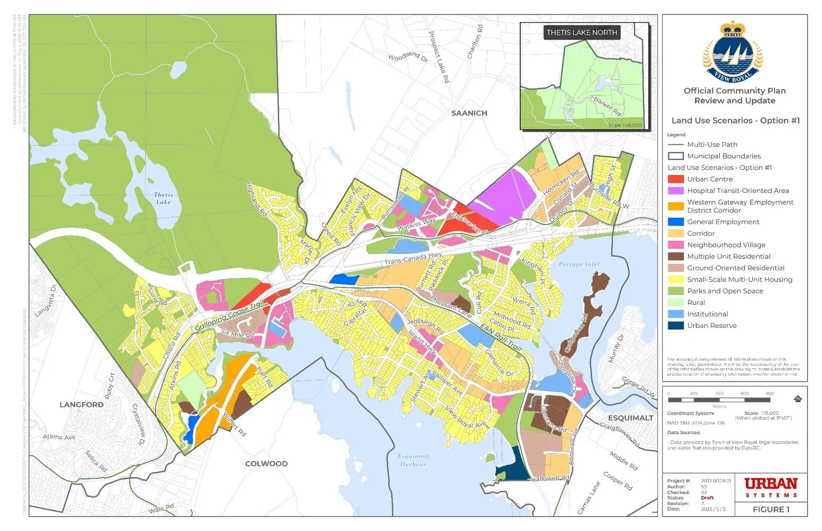
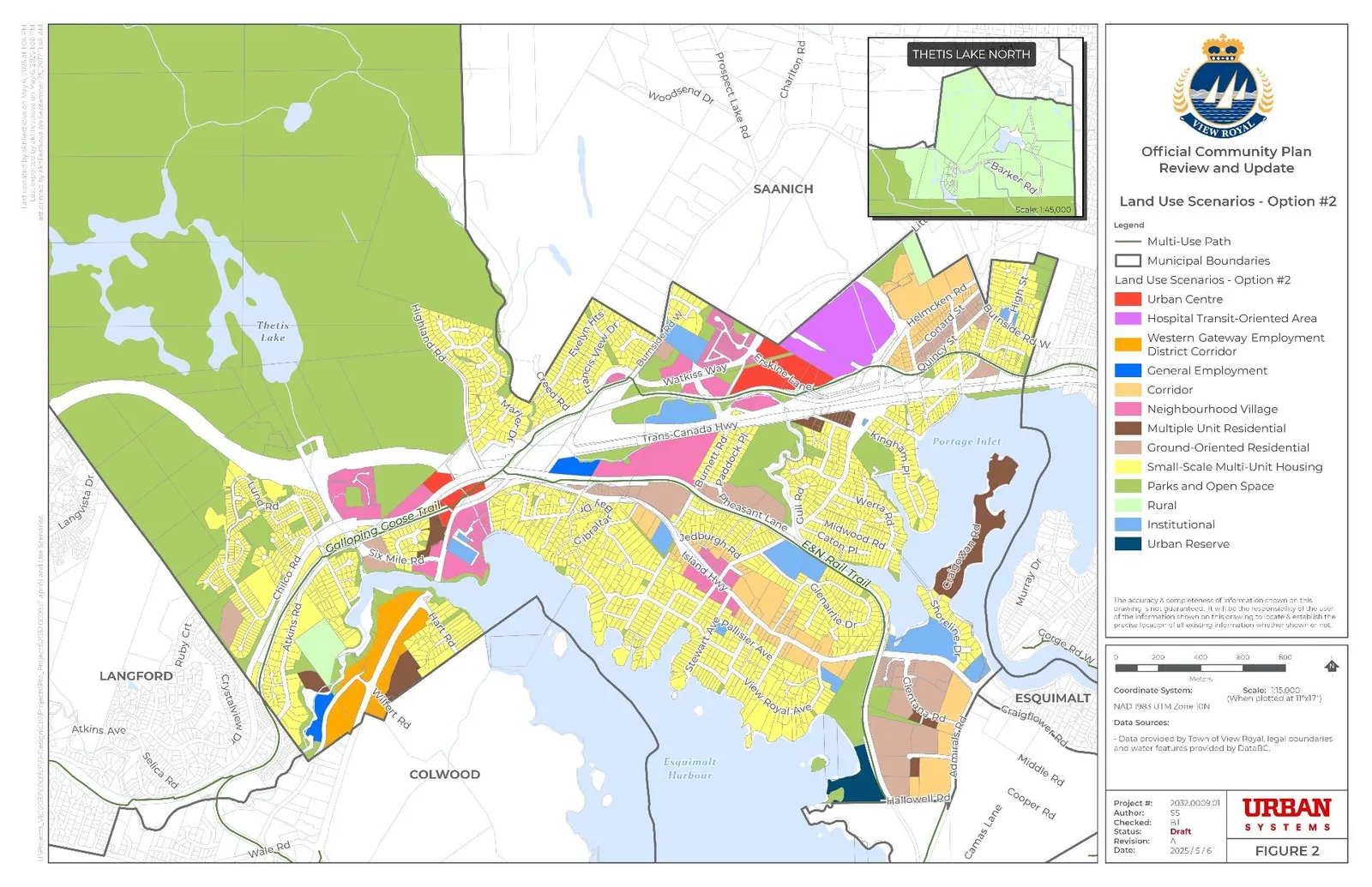
The following section introduces two proposed land use scenarios for future growth and development of View Royal for review and consideration. These scenarios aim to align with community feedback and legislative requirements while supporting the vision for View Royal's future. Key elements of both scenarios are highlighted in the following section, followed by an overview of the distinct elements of each scenario. For visual references, see Figure 5 for Land Use Scenario #1 and Figure 6 for Land Use Scenario #2.
The following are key similarities that exist between the two scenarios:
- A Hospital Transit-Oriented Area has been proposed on the site of the Victoria General Hospital and immediately adjacent properties to accommodate the provincially-legislated Transit-Oriented Development Area.
- Introduction of an Urban Centre Designation to further support compact development in areas where rapid and/or frequent transit service is provided and address the community's desire for more mixed-use development with commercial amenities and services
- This designation includes lands within the Transit-Oriented Development Area, as legislated by the Province. This builds upon an area already undergoing development near the Victoria General Hospital by transitioning density permissions from the area with a proposed designation of Hospital TOA (this encompasses lands that are within a 200 m radius of the transit exchange where densities of up to 10 storeys must be permitted) to those lands within the 200 m - 400 m radius of the transit exchange that are proposed as Neighbourhood Village. On these parcels, lower densities of up to 6 storeys must be permitted.
- A second Urban Center is proposed where Highway 1, Island Highway, Atkins Road, Galloping Goose, and the E&N Rail intersect to complement the addition of the Park and Ride facility proposed at this location, as per the Ministry of Transportation and Transit’s South Island Transportation Strategy.
- The Western Gateway Employment District Corridor proposes mixed-use development along Island Highway between Six Mile Road and the Colwood boundary. This aligns with a desire to concentrate higher densities along this corridor while allowing for flexibility to promote employment-based uses through the permission of residential units. This will ensure that opportunities to encourage and permit commercial and industrial uses are maximized by adding residential uses to increase viability.
- General Employment lands are intended to support employment-generating activities, including light industrial operations, commercial enterprises, and office spaces, and amongst others. General Employment lands do not support residential uses. 1 Adams Place is proposed as General Employment in both scenarios.
- Neighbourhood Villages are proposed at the following locations:
- Southwest of the proposed Urban Centre to account for lots that fall in the TOA catchment area and to function as a transition away form the higher densities proposed in the Urban Centre;
- North of Watkiss Way and East of Burnside Road to function as a transition away from the higher densities proposed in the Urban Centre;
- The subdivision east of Six Mile Road and Presley Place south of Thetis Lake Regional Park (Lakeside Village);
- At the intersection of Island Highway and Helmcken Road where there is existing interest in development; and
- South of the proposed Urban Centre and future Atkins Park and Ride facility near the existing CRD Water Services building
- A Corridor is proposed south of Helmcken Road between the Saanich boundary and the Galloping Goose near the Eagle Creek development and Victoria General Hospital to align with the community's desire for more mixed-use developments with commercial amenities, services, and economic growth. This designation aids in providing a gradual transition in height and density between the Hospital Transit-Oriented Area to the west and existing residential neighbourhood to the south.
- A Corridor is proposed along Island Highway, between the two E&N Rail intersections to serve the existing adjacent low density residential neighbourhoods of Helmcken and Harbour.
- Park designations remained unchanged to align with the community’s desire to preserve, protect, and expand View Royal parks, trails and greenspace, and natural environment.
- A Multiple Unit Residential designation has been introduced to permit medium-density residential development, such as apartments, -plexes, and community care facilities. It is important to note that multi-unit residential development may be constructed in the Urban Centre, Neighbourhood Village, Western Gateway Employment District Corridor, and Corridor designations, which allow the market to decide whether to develop medium-density as standalone apartments or mixed-use developments. Multiple Unit Residential has been proposed at the following locations in both scenarios:
- Along Craigowan Road to align with existing zoning permissions
- Two sites adjacent to the proposed Western Gateway Employment District Corridor to align with existing zoning permissions (one off Atkins Rd and a second off Wilfert Rd)
- Introduction of a Ground-Oriented Residential designation to support the need for diverse housing options and to allow for a more gradual transition to the single-detached housing in the existing abutting neighbourhoods. Unlike the SSMUH designation, Ground-Oriented Residential does not support single-detached homes.
- Residential and Large Lot Residential have been redesignated to Small-Scale Multi-Unit Housing. Since SSMUH already applies to most residential lot designations, extending this designation to all residential and large lot residential areas simplifies land use planning, ensures consistency in housing development regulations, and provides more housing options.
- The Rural designation remains unchanged and continues to account for land within the Agricultural Land Reserve or lots otherwise intended for large lot residential uses or small-scale farming.
- The Urban Reserve is a designation for land within View Royal that is intended to be transferred to a First Nation community within the lifespan of this OCP.
4.2.1 Scenario #1
The following are key highlights for Scenario #1 (that differ from Scenario #2):
- The redevelopment of the Fort Victoria RV Park into a Corridor would extend the proposed Corridor designation along Island Highway, between the two E&N Rail intersections allowing for continuous mixed-use development in a central area of the community and a regionally-travelled route. Similar to Scenario #2, this designation allows the opportunity for diverse housing options, including inclusive affordable housing options, and to allow for a more gradual transition to the single-detached housing in the existing abutting neighbourhood.
- The Western Gateway Employment District Corridor proposes densities up to 10 storeys with primarily employment land uses and some residential. Land use policies that encourage development beyond 10 storeys and FSR above 3.5 can unlock the potential of development in this area. Therefore, it is proposed to provide bonus densities up to 15 storeys (up to 4.0 FSR) to incentivize the provision of community amenities (e.g. park, daycare, community hall, courtyard, etc.) and additional floor space dedicated to employment land uses.
- Additional Neighbourhood Villages are proposed at the following locations:
- Intersection of View Royal Ave, South of Island Highway near the View Royal Municipal Hall; and
- At the Intersection of Shoreline Drive and Island Highway, between Shoreline Community Middle School and the Victoria Scottish Community Centre.
4.2.2 Scenario #2
The following are key highlights for Scenario #2 (that differ from Scenario #1):
- The Western Gateway Employment District Corridor proposes densities up to 6 storeys with primarily employment uses and some residential.
- Scenario #2 suggests expanding ground-oriented residential development in the Craigflower neighbourhood, while Scenario #1 proposes multi-unit residential along Island Highway in the Glentana Rd area.
- The current Fort Victoria RV park is proposed as a Neighbourhood Village allowing for a mix of commercial, residential, and civic uses to serve local neighbourhood needs. Similar to Scenario #1, this designation allows the opportunity for diverse housing options, including inclusive affordable housing options, and to allow for a more gradual transition to the single-detached housing in the existing abutting neighbourhood.
- A portion of the area around the future Atkins Park and Ride site north of the Galloping Goose is proposed as a Neighbourhood Village in Scenario #2, whereas this area is proposed as Urban Centre in Scenario #1. The proposed lower densities in Scenario #2 allow for a stronger transition in building heights between these lots and the existing residential neighbourhood located to the south of the Galloping Goose.
- The existing residential area on Damon Drive south of the Galloping Goose trail is proposed as SSMUH in Scenario #2 to acknowledge the area’s existing residential use.
- Lands to the north of Island Hwy and south of the E&N Rail Trail, west of Brunett Rd are proposed for Ground-Oriented Residential in Scenario #2 to better increase opportunities for diverse housing forms in the area while still providing density to support the proposed adjacent Neighbourhood Centre to the north at the Fort Victoria RV Park site and the Corridor along Island Highway to the east. Scenario #1 proposes these lands as Corridor.
4.3 CLOSING / NEXT STEPS
The proposed land use concepts discussed in this memo are for consideration by Town staff. These concepts will be presented to members of the community, OCP Advisory Committee, and Council for consideration and feedback to ensure proposed land use scenarios align with the aspirations and needs of View Royal's residents, businesses, and stakeholders. A preferred concept will be selected and refined after engagement with the community occurs in mid- to late May. This concept will guide the land use map for the OCP 50% draft for Council and OCP Advisory Committee review in the summer.
¹ Province of British Columbia, Ministry of Housing. Order of the Minister of Housing. Housing Supply Act. Ministerial Order No. M262. 2024. Link to BC Laws ² Ministry of Housing and Municipal Affairs. Thousands of homes on the way through housing targets in more communities. Link to news.gov.bc.ca ³ Town of View Royal. Housing Needs Assessment Report. 2024. Link to View Royal Document ⁴ von Bergmann J., Davidoff T., Huang A., Lauster, N., Somerville T. SSMUH and TOA Scenarios in British Columbia. Ministry of Housing. 2023. Link to Gov BC Document ⁵ The Victoria Census Metropolitan Area includes the Township of Esquimalt, District of Oak Bay, District of Saanich, City of Victoria, Town of View Royal, District of Central Saanich, District of North Saanich, Town of Sidney, City of Colwood, District of Highlands, City of Langford, District of Metchosin, and District of Sooke. ⁶ As the BC SSMUH Report does not specify the projection years, the following section assumes that projections begin in 2024, based on the publication date of December 2023. ⁸ Housing Statues (Transit-Oriented Areas) Amendment Act, 2023, S.B.C. 2023. C.48. ⁹ Town of View Royal. Zoning Bylaw No 900. 2014. Link to View Royal Bylaw ¹⁰ Ministry of Housing. Attachment 3: Bill 47 Transit-Oriented Development Areas Distances, transit Stations and Densities by Category. Link to Gov BC Document ¹¹ See the Town of View Royal Land Economics Study Update completed by Urban Systems in 2025 for further discussion on the viability of mixed-use developments.