STAFF REPORT: DEVELOPMENT PERMIT WITH VARIANCES APPLICATION NO. 2025-06 - 2818 SHORELINE DRIVE
Report considering a development permit with multiple variances for a residential dwelling and walkway at 2818 Shoreline Drive.
TOWN OF VIEW ROYAL COUNCIL REPORT
TO: Council
DATE: November 21, 2025
FROM: Jeff Chow, RPP, MCIP, Senior Planner
MEETING DATE: December 2, 2025
DEVELOPMENT PERMIT WITH VARIANCES APPLICATION NO. 2025-06 - 2818 SHORELINE DRIVE
RECOMMENDATION:
THAT Council authorize the issuance of Development Permit with Variances Application No. 2025-06 for 2818 Shoreline Drive in accordance with plans submitted to the Development Services Department on July 14, 2025, subject to the development meeting the regulations of Zoning Bylaw No. 900, 2014, except for the following variances:
- increase to the maximum height of a detached residential building from 7.5m to 8.0m.
- reduce the minimum front lot line setback for a principal building from 7.5m to 6.4m.
- reduce the minimum setback for an accessory structure from the rear lot line from 1.2m to 0.0m to permit an elevated wooden walkway.
- reduce the minimum setback for an accessory structure from the natural boundary of the sea from 15.0m to 0.0m to permit an elevated wooden walkway.
AND THAT Development Permit with Variances Application No.2025-06 for 2818 Shoreline Drive include the following as conditions of the development permit:
- Works are to be conducted in accordance with the recommendations of the following reports: a. “Natural Watercourse and Shoreline Development Permit Area Review for 2818 Shoreline Drive, Victoria, BC, Town of View Royal” prepared by Swell Environmental Consulting and dated July 10, 2025. b. “Tree Assessment and Development Report” prepared by Scotty Tree & Arborist and dated July 10, 2025. c. “Flood Construction Level Assessment” prepared by Ryzuk Geotechnical and dated September 22, 2023.
- A landscape security deposit of $43,000.00 for landscaping and protection of the natural environment shall be provided prior to the issuance of a building permit.
ALTERNATIVE OPTIONS:
THAT Development Permit Application with Variances Application No.2025-06 for 2818 Shoreline Drive be declined.
Should Council support this alternative option, the best practice is for Council to provide detailed reasons why it was considered that the application does not comply with the Natural Watercourse and Shorelines Development Permit Area guidelines and/or why a variance is not supported.
PURPOSE:
The purpose of this report is to consider Development Permit with Variances Application No. 2025-06 for 2818 Shoreline Drive to alter land in the Natural Shoreline and Watercourse Development Permit Area (DPA), vary height and siting requirements for a proposed detached dwelling, and vary siting requirements for a walkway.
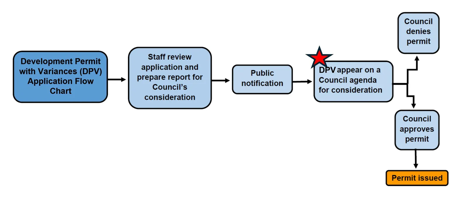
DEVELOPMENT APPLICATION PROCESS:
Figure 1 below outlines the Development Permit with Variance application process. The red star identifies where the application falls within the process.
BACKGROUND:
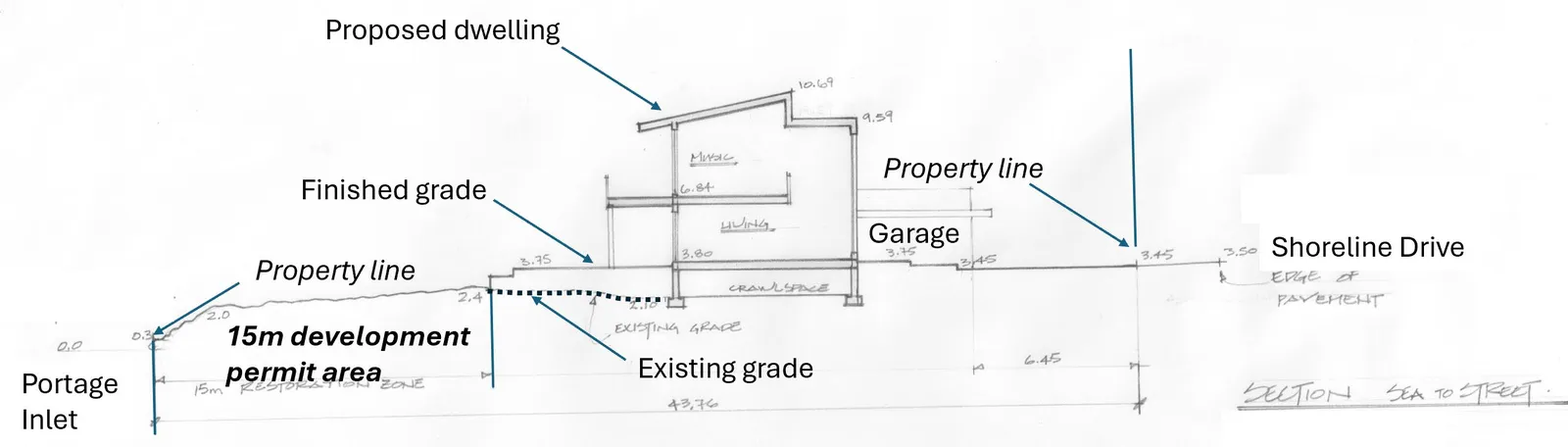
The proposal was introduced at the November 12, 2025, Council meeting. The staff report can be found in Attachment A. Supplemental information requested at the meeting is provided in this report and includes a site cross-section in Attachment B (see also Figure 2) and a contour map of the area in Attachment C (see also Figure 3) to illustrate potential sea level rise impacts in the immediate neighbourhood.
ANALYSIS:
Site Section
The site section from Attachment B is annotated in Figure 2 below to show how the grade is proposed to be raised to protect the dwelling from a 1.0m relative sea level rise that could occur by 2100.
Area Contour Map
The area contour map in Figure 3 below shows the approximate flood construction level for a 1.0m relative sea level rise. Air photographs and contour lines are less precise when examining smaller areas; however, it generally shows that the end of Shoreline Drive may not be subject to much inundation from “blue-water flooding” caused by sea level rise, high tide and storm surge as delineated by the orange line.
The 3.68m recommended Flood Construction Level is the elevation of the underside of a floor system that is considered by the applicant’s professional engineer to withstand a 1.0m relative sea level rise. That can be achieved by either siting livable building floor areas in the areas above the Flood Construction Level contour (white dashed line in Figure 3) and/or constructing a higher flood resistant foundation in areas below the Flood Construction Level contour.
Document Images
(1)