Report to Council: Re: DP with Variances Application No. 2025-06 - 2818 Shoreline Drive
A staff report from the Senior Planner recommending that Council authorize the issuance of a Development Permit with Variances for 2818 Shoreline Drive.
Report to Council Re: DP with Variances Application No. 2025-06 - 2818 Shoreline Drive Meeting Date: December 2, 2025
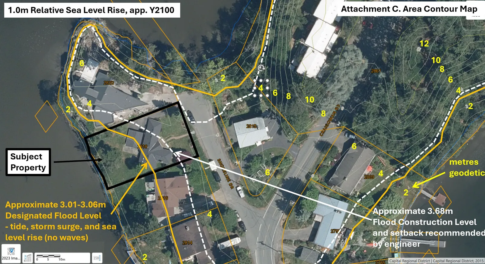
Figure 3: Area contour map
The Adjacent Property Impact Review form evaluating offsite impacts can be found in Attachment D.
Notice of this meeting to consider this application was made in accordance with Development Procedures Bylaw No.730, 2009. Staff recommends that Development Permit with Variance 2025-06 for 2818 Shoreline Drive be approved.
Impacts and implications can be summarized as follows:
Community Impact:
The two-storey building would not be out of scale in the neighbourhood because the raised, finished grade would be nearly level with the road. The siting of garage would not be obtrusive in this location near the end of a cul-de-sac.
Should the application proceed, a notice will be prepared and distributed to all properties within 100m of the subject property and outline the variances requested.
Financial Implications:
There are no financial implications for the Town.
Inter-governmental Relations Impact:
n/a
ALIGNMENT:
The recommended option aligns with the Town’s following core guiding documents as follows:
Strategic Plan: n/a
Official Community Plan:
- Policy NE1.5 Aquatic and Riparian Resources and Ecosystems
- Policy NE1.6 Native Trees and Vegetation
- Policy IS2.1 Environmentally Sensitive Design
Ensure that infrastructure and services are designed and located to be sensitive to surrounding land uses, and reduce or eliminate adverse impacts to the natural environment. Design considerations should include:
- Utilizing natural features and systems such as trees, vegetation, and riparian areas for natural stormwater absorption and treatment.
- Mimicking and incorporating natural systems.
Other Policy Documents: n/a
PUBLIC PARTICIPATION GOAL:
The desired level of public participation for the recommended option is:
- Inform
- Consult
- Involve
- Collaborate
- Empower
- N/A
TIME CRITICAL:
There are no timing considerations for the Town.
CONCURRENCE:
| Role | Initials | Comments |
|---|---|---|
| Chief Administrative Officer | SS | I concur with the recommendation. |
REVIEWED BY:
| Role | Initials |
|---|---|
| Director of Corporate Administration | n/a |
| Director of Finance & Technology | n/a |
| Director of Development Services | LT |
| Director of Engineering | n/a |
| Director of Protective Services | n/a |
ATTACHMENTS:
A. Report dated October 24, 2025, from the Senior Planner titled “Development Permit with Variances Application No. 2025-06 - 2818 Shoreline Drive” B. Site Section C. Area contour map D. Adjacent Property Impact Review