TOWN OF VIEW ROYAL COMMITTEE OF THE WHOLE REPORT: DEVELOPMENT PERMIT WITH VARIANCES APPLICATION NO. 2025-06 - 2818 SHORELINE DRIVE
A detailed report evaluating the development proposal at 2818 Shoreline Drive against the Town's guidelines for shoreline protection and zoning requirements.
TOWN OF VIEW ROYAL COMMITTEE OF THE WHOLE REPORT
TO: Committee of the Whole FROM: J. Chow, RPP, MCIP, Senior Planner DATE: October 24, 2025 MEETING DATE: November 12, 2025
DEVELOPMENT PERMIT WITH VARIANCES APPLICATION NO. 2025-06 - 2818 SHORELINE DRIVE
RECOMMENDATION:
THAT the Committee recommend that Council, after giving notice, consider the following motion:
THAT Council authorize the issuance of Development Permit with Variances Application No. 2025-06 for 2818 Shoreline Drive in accordance with plans submitted to the Development Services Department on July 14, 2025, subject to the development meeting the regulations of Zoning Bylaw No. 900, 2014, except for the following variances:
- Increase to the maximum height of a detached residential building from 7.5m to 8.0m.
- Reduce the minimum front lot line setback for a principal building from 7.5m to 6.4m.
- Reduce the minimum setback for an accessory structure from the rear lot line from 1.2m to 0.0m to permit an elevated wooden walkway.
- Reduce the minimum setback for an accessory structure from the natural boundary of the sea from 15.0m to 0.0m to permit an elevated wooden walkway.
AND THAT Development Permit with Variances Application No.2025-06 for 2818 Shoreline Drive include the following as conditions of the development permit:
- Works are to be conducted in accordance with the recommendations of the following reports: a. “Natural Watercourse and Shoreline Development Permit Area Review for 2818 Shoreline Drive, Victoria, BC, Town of View Royal” prepared by Swell Environmental Consulting and dated July 10, 2025. b. “Tree Assessment and Development Report” prepared by Scotty Tree & Arborist and dated July 10, 2025. c. “Flood Construction Level Assessment” prepared by Ryzuk Geotechnical and dated September 22, 2023.
- A landscape security deposit of $43,000.00 for landscaping and protection of the natural environment shall be provided prior to the issuance of a building permit.
ALTERNATIVE OPTIONS:
THAT Development Permit Application with Variances Application No.2025-06 for 2818 Shoreline Drive be declined.
Should Council support this alternative option, the best practice is for Council to provide detailed reasons why it was considered that the application does not comply with the Natural Watercourse and Shorelines Development Permit Area guidelines and/or why a variance is not supported.
PURPOSE:
The purpose of this report is to introduce Development Permit with Variances Application No. 2025-06 for 2818 Shoreline Drive to alter land in the Natural Shoreline and Watercourse Development Permit Area (DPA), vary height and siting requirements for a proposed detached dwelling, and vary siting requirements for a walkway.
DEVELOPMENT APPLICATION PROCESS:
Figure 1 below outlines the Development Permit with Variance application process. The red star identifies where the application falls within the process.
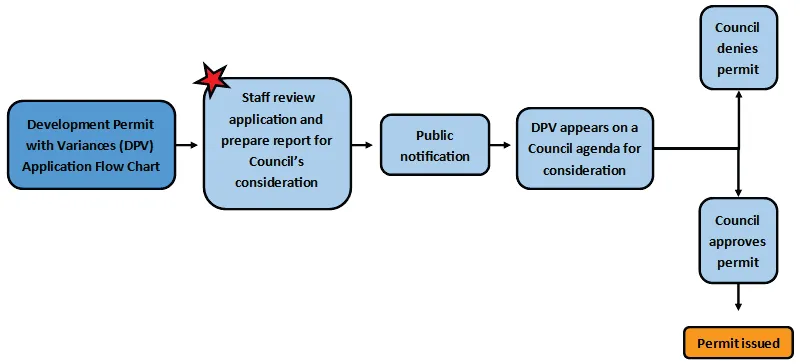
Figure 1: Development Permit with Variances (DPV) application process
BACKGROUND:
The 1087m² subject property is a waterfront parcel situated on Portage Inlet as shown in Figure 2. The shore is a shallow mudflat. A 1950s-era dwelling has been decommissioned for relocation off site.
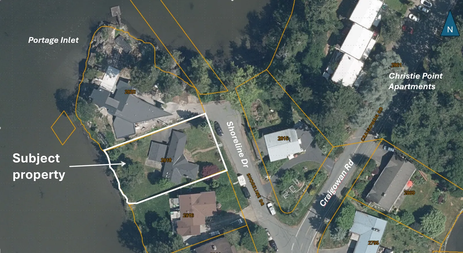
Figure 2. Property location air photo, 2023
As shown in Figure 3, the rear yard is primarily lawn with ornamental plants. There are four trees in the rear yard: two Douglas firs, one Deodar Cedar and a Garry oak with a pronounced lean (see Figure 4).
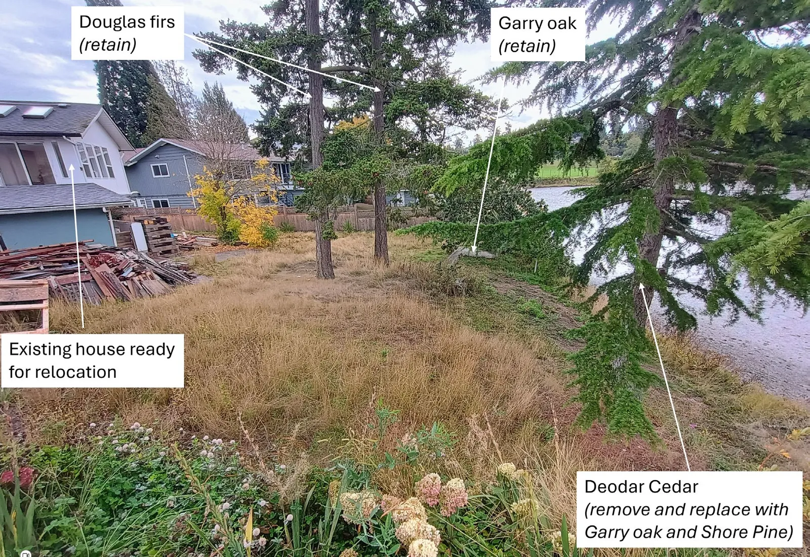
Figure 3. View of rear yard development permit area, 2025
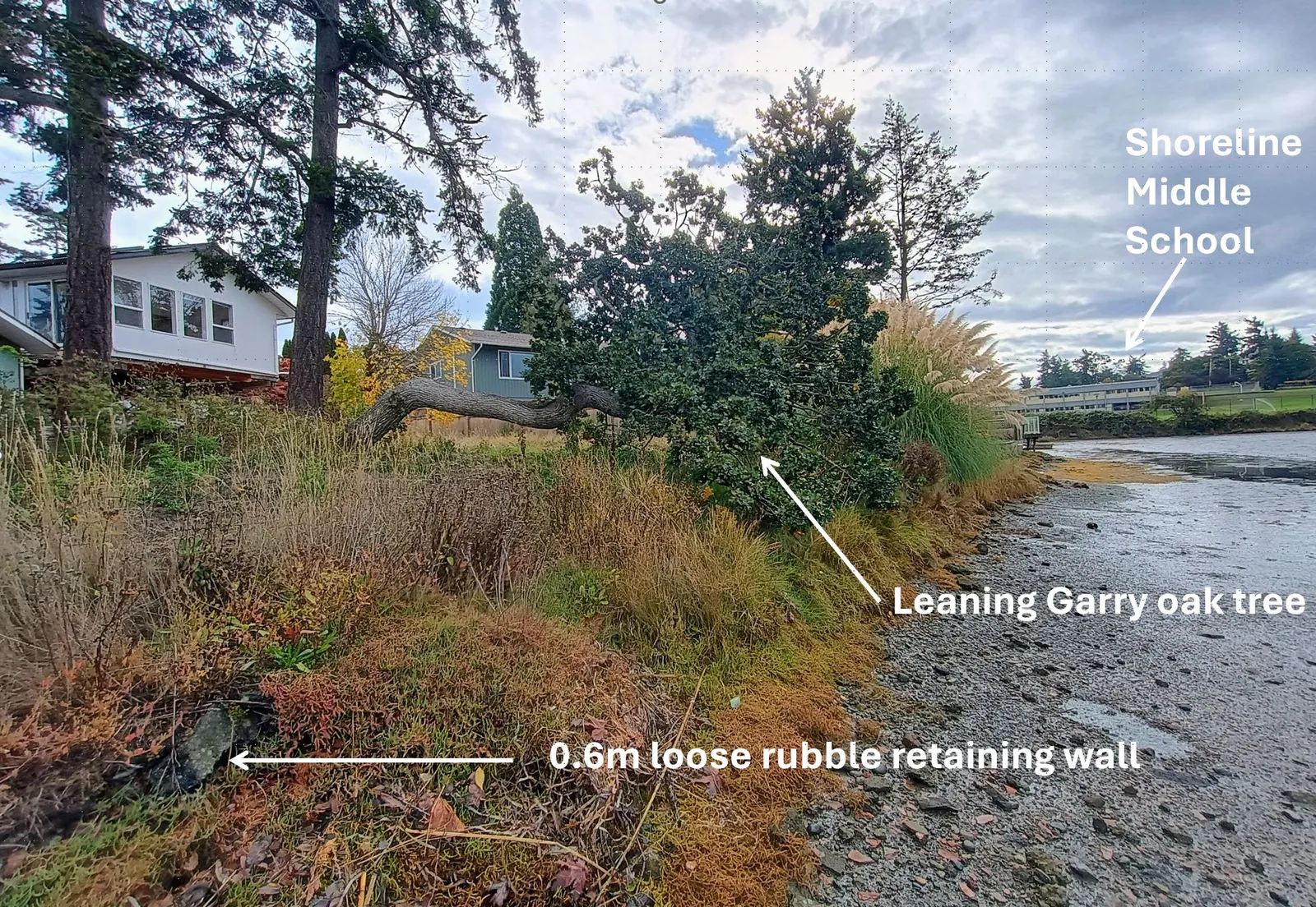
Figure 4. View along Portage Inlet shoreline
DESCRIPTION OF PROPOSAL
The applicant proposes to alter land within the Natural Watercourse and Shoreline DPA and construct a new dwelling (Attachments 2 and 5).
Proposed works within the DPA are shown in Figure 5 and are as follows:
- Remove ornamental plantings and lawn in rear yard.
- Replant 93.3% of land within the development permit area with native plants and salt tolerant plants (near the natural boundary).
- Construct a 0.6m wide elevated wooden walkway (< 0.4m high) and gravel path on 6.7% of the land within the DPA for shore and yard access, respectively.
- Remove one non-native Deodar cedar and replace with one Garry oak and one Shore pine along the north property line. The replacement trees are native species suited to the location.
- Install a storm water infiltration trench & overflow lawn basin, or alternatively a drain rock-lined dry riverbed.
- Repair a 0.6m high rubble retaining wall (see Figure 4) along the natural boundary with hand-placed rocks to create planting pockets.
- Construct a retaining wall up to 1m tall along the south boundary where the adjacent property is lower.
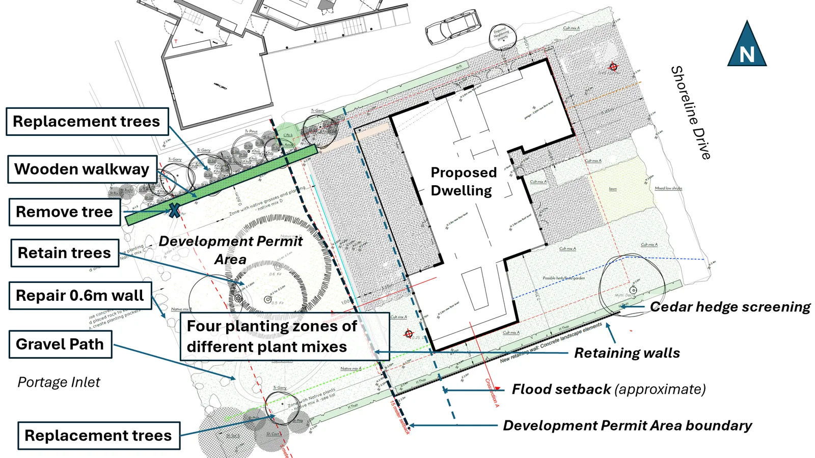
Figure 5. Proposed site work
Variances to Zoning Bylaw requirements are also requested as follows:
- Increase the maximum building height from 7.5m to 8.0m for the principal dwelling.
- Reduce the front lot line setback from 7.5m to 6.4m for a principal dwelling.
- Permit a structure (0.6m wide wooden walkway) within 0m of the natural boundary and the rear lot line.
The Zoning Bylaw requires a security deposit for landscaping and screening installation to ensure that all such works are completed in accordance with the approved development permit. If the development permit is approved, a works and services agreement and a tree permit will be required prior to building permit issuance.
ANALYSIS:
Development Permit Area Guidelines
The Natural Watercourse and Shoreline DPA applies to the area within 15m of the natural boundary of the sea. On this property it covers much of the rear yard. A summary of how the proposal addresses the DPA guidelines can be found in Attachment 6. The proposal can be supported because it would substantially comply with guidelines by:
- Restoring 93% of land within the DPA with native species and ecologically appropriate vegetation. This would be almost double the DPA target of 50% of the shore length.
- Siting the elevated wooden walkway and gravel path to minimize impact on trees and sensitive areas.
- Managing storm water by using an infiltration trench and overflow lawn basin or alternatively a drain rock lined dry riverbed to sensitively manage storm water by focusing on infiltration and release of storm water in ways and quantities that mimics natural patterns, avoids scouring and erosion, and results in fewer pollutants entering the sea.
- Repairing loose areas in the approximately 0.6m high retaining wall with hand placed rocks. The work would be minor and would have little environmental impact.
- Retaining the leaning Garry oak that overhangs the waters edge would be preserved as strongly encouraged in the DPA guidelines to provide shade, protection and feeding habitat for fish and wildlife.
Variances
1. Variance to increase the permitted height of a building from 7.5m to 8.0m
The height variance is requested to address coastal flood hazards. The submitted Flood Level Risk Assessment prepared by Ryzuk Geotechnical (Attachment 4) recommends a 3.46m (CGVD28) flood construction level, which is the minimum elevation for the underside of a building’s floor system for habitable space. Most of the lot has a grade less than 3.46m.
The proposal includes raising the grade of the land that is outside of the DPA by approximately 0.68 m to avoid flooding as shown in Figure 6 and 7 below. In this case, the building height is measured from the existing grade because it would be lower than the finished grade. The variance is requested so that a two-storey building can be built.
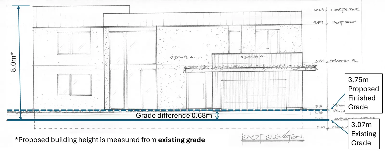
Figure 6. Existing and Finished Average Grade (View from Shoreline Drive)
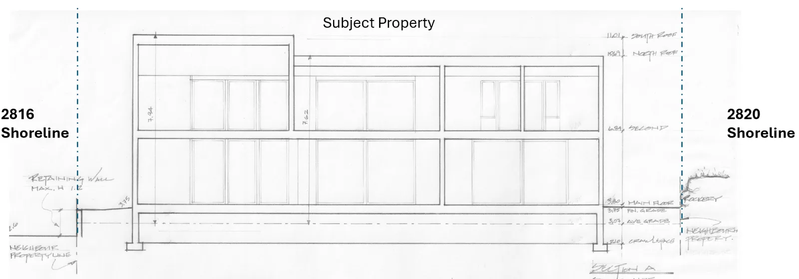
Figure 7. Site section (view from Shoreline Drive)
The requested variance is supportable for the following reasons:
a. The building would be two stories and fairly level with the road: the main floor grade of the building would be 3.8m compared to Shoreline Drive, which ranges from 3.2 to 3.8m along the property frontage. b. Impacts to adjacent properties are anticipated to be minor, as follows: i. The subject property and proposed dwelling will still be lower than the adjacent property at 2820 Shoreline. ii. The building would be screened from the adjacent lower property at 2816 Shoreline Drive by a new cedar hedge to minimize overlook. iii. By raising the front yard of the subject property, the grade difference with the adjacent property at 2816 Shoreline Drive would be increased by 0.68m at most as shown in Figure 7. If the property 2816 Shoreline Drive were to be redeveloped in the future, the grade of that property could also be expected to be raised an equivalent amount to meet the recommended Flood Construction Level.
2. Variance to reduce front lot line setback for a principal building from 7.5m to 6.4m
The requested variance to site the attached garage, as shown in Figure 8, can be supported for the following reasons:
a. The majority of the dwelling would be sited approximately 11m from the front lot line, exceeding the R-1 zone minimum setback of 7.5m. b. No significant streetscape impacts in this location are anticipated by siting the garage 1.1m closer to the road because the subject property is the second to last property at the end of the cul-de-sac. The majority of buildings along Shoreline have a setback of approximately 7.5m. In addition, native plants and grass would be planted in the front yard to soften the streetscape appearance. c. The Flood Risk Level Assessment recommends a flood setback of 19-22m from the present natural boundary to reduce risk. This is more restrictive than the Zoning Bylaw’s minimum setback of 15m from the natural boundary of the sea because it shifts building envelope closer to Shoreline Drive. d. The garage driveway is not required for on-site parking, but the proposed length of 6.4m can accommodate most vehicles. For example, the minimum length of a required parking space in the Zoning Bylaw is 5.5m.
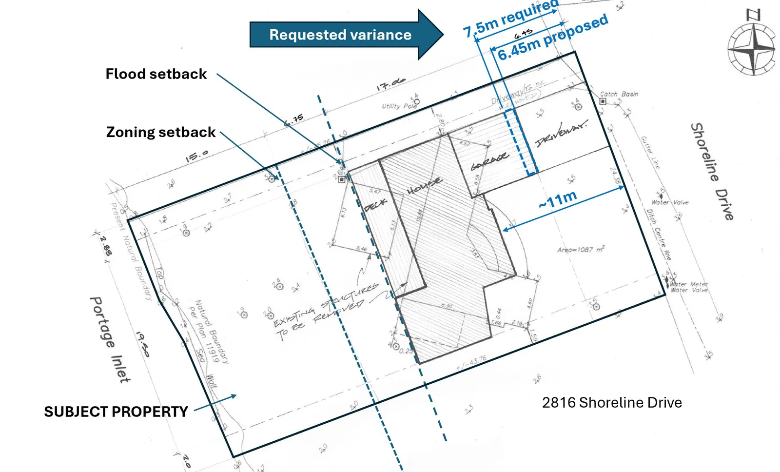
Figure 8. Requested siting variance
3. Variances to site an accessory structure on the rear lot line and the natural boundary of the sea.
The applicant proposes to construct a 0.6m wide elevated wooden walkway through the DPA as shown in Figure 5 above. The Zoning Bylaw requires accessory structures to be set back 1.2m from the rear lot line. It also requires that accessory structures not be located within 15m from the natural boundary of the sea. There are two variances to facilitate the construction of the wooden walkway because the rear lot line is a fixed lot line on the subdivision plan defining the extent of the parcel, while the natural boundary of a watercourse is dynamic and can change over time.
The raised walkway would provide access from the higher part of the property to the shoreline as coastal inundation and sea level rise shifts the natural boundary upland over time. The requested variances can be supported because no impacts to adjacent properties are anticipated.
Neighbour Correspondence
The applicant provided correspondence from two abutting property owners indicating their support for the application (Attachment 8).
Impacts and implications can be summarized as follows:
Community Impact: The two-storey building would not be out of scale in the neighbourhood because the raised, finished grade would be nearly level with the road. The siting of garage would not be obtrusive in this location near the end of a cul-de-sac.
Should the application proceed, a notice will be prepared and distributed to all properties within 100m of the subject property and outline the variances requested.
Financial Implications: There are no financial implications for the Town.
Inter-governmental Relations Impact: n/a
ALIGNMENT:
The recommended option aligns with the Town’s following core guiding documents as follows:
Strategic Plan: n/a
Official Community Plan: Policy NE1.5 Aquatic and Riparian Resources and Ecosystems Policy NE1.6 Native Trees and Vegetation Policy IS2.1 Environmentally Sensitive Design Ensure that infrastructure and services are designed and located to be sensitive to surrounding land uses, and reduce or eliminate adverse impacts to the natural environment. Design considerations should include:
- Utilizing natural features and systems such as trees, vegetation, and riparian areas for natural stormwater absorption and treatment.
- Mimicking and incorporating natural systems
Other Policy Documents: n/a
PUBLIC PARTICIPATION GOAL:
The desired level of public participation for the recommended option is: [X] Consult
TIME CRITICAL:
There are no timing considerations for the Town.
| CONCURRENCE: | Initials | Comments |
|---|---|---|
| Chief Administrative Officer | SS | I concur with the recommendation. |
| REVIEWED BY: | Initials |
|---|---|
| Director of Corporate Administration | n/a |
| Director of Finance & Technology | n/a |
| Director of Development Services | LT |
| Director of Engineering | IL |
| Director of Protective Services | n/a |
ATTACHMENTS:
- Letter to Mayor and Council, August 1, 2025
- “Natural Watercourse and Shoreline Development Permit Area Review for 2018 Shoreline Drive, Victoria, BC, Town of View Royal” prepared by Swell Environmental Consulting and dated July 10, 2025
- “Tree Assessment and Development Report” prepared by Scotty Tree & Arborist and dated July 10, 2025
- Flood Construction Level Assessment – Ryzuk Geotechnical, September 22, 2023
- Building Plans - Ronan Design June 6, 2025
- Natural Watercourse and Shoreline Development Permit Area
- Property Impact Review
- Correspondence from Neighbours, July 26/28, 2025
Document Images
(1)