Annual Report 2023 - COMMUNITY PROFILE & STATISTICS
Overview of the Town's demographics, geography, and municipal services provided by the Town and the Capital Regional District.
COMMUNITY PROFILE
The Town of View Royal is located on southern Vancouver Island, approximately six kilometers west of Victoria, British Columbia. On December 5, 1988 – with a population of less than 5,000 – the Town of View Royal was incorporated and became its own distinct municipality comprising approximately 2,500 hectares of land. The municipality encompasses McKenzie, Pike, Prior and Thetis Lakes and portions of Esquimalt Harbour and Portage Inlet and is situated adjacent to the established jurisdictions of the City of Colwood, Township of Esquimalt, Esquimalt First Nation, District of Highlands, City of Langford, District of Saanich and Songhees First Nation.
The Town of View Royal acknowledges with respect that it is within the unceded traditional territories of the Lekwungen peoples, known today as the Esquimalt and Songhees Nations, and that their historic connections to these lands continue to this day.
STATISTICS
- 13,219 POPULATION*
- 14.33KM² LAND AREA
- 5,294 HOUSEHOLDS*
- 72 MUNICIPAL PARKS & 2 REGIONAL PARKS
- 30.5KM BIKE LANES
- 27.3KM TRAILS
*as per 2023 BC Stats Estimate
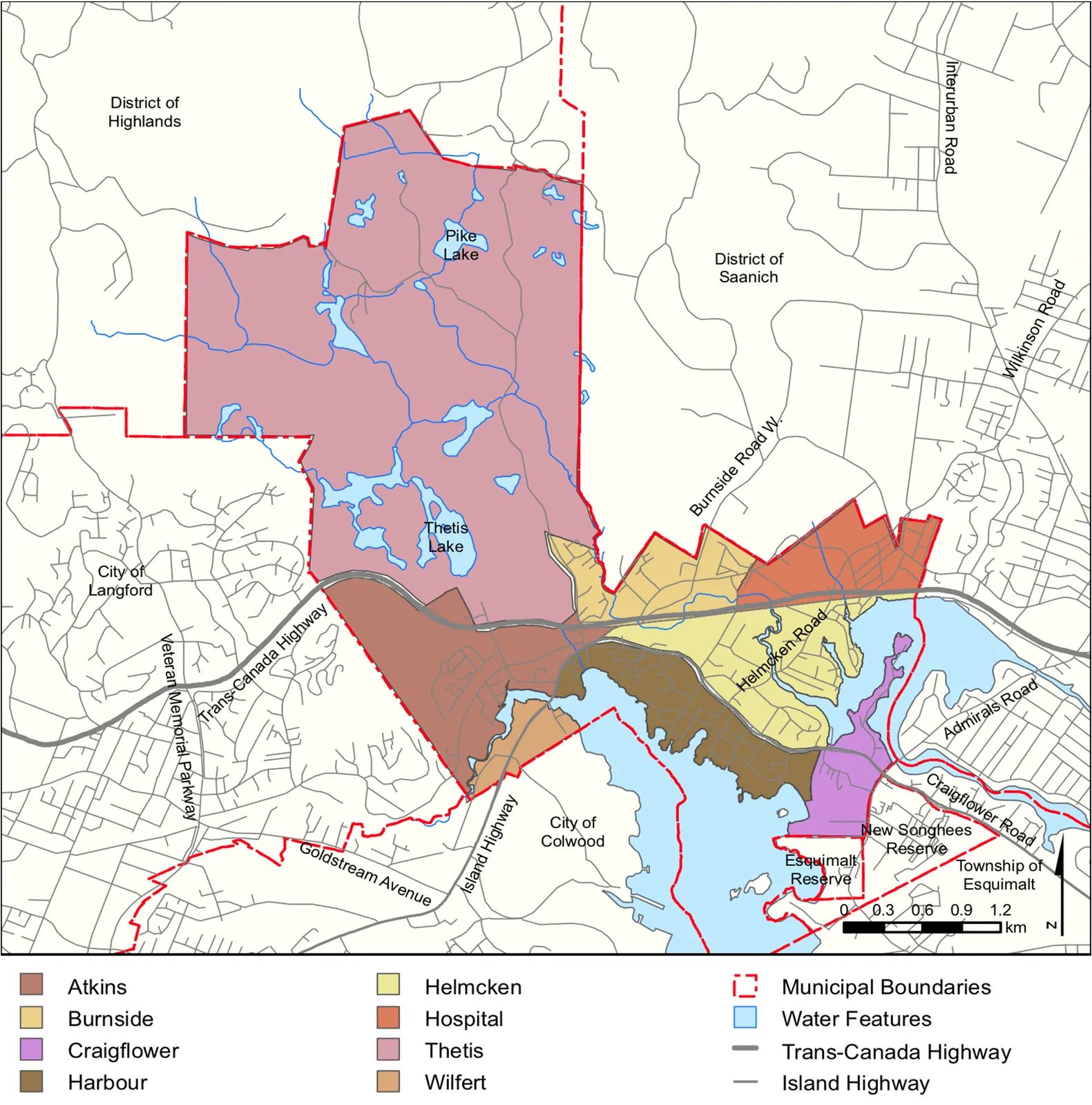
PRECINCTS
View Royal is divided into eight distinct precincts based on such factors as topography, major transportation corridors, natural environment and the age of housing stock.
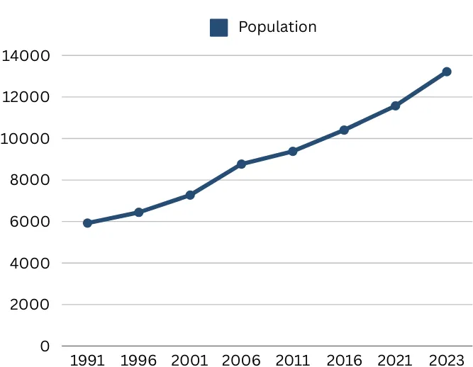
POPULATION GROWTH & DEVELOPMENT
The Town has experienced significant growth and development while still maintaining much of its small town character. The Town has 270ha of remaining residential-zoned land within the Urban Containment Boundary.
Census Data
- 1991: 5,925
- 1996: 6,441
- 2001: 7,271
- 2006: 8,768
- 2011: 9,381
- 2016: 10,408
- 2021: 11,575
- 2023: 13,219*
*as per 2023 BC Stats Estimate
SUMMARY OF SERVICES & OPERATIONS
TOWN OF VIEW ROYAL SERVICES
The Town of View Royal is responsible for the provision of a wide variety of local services and programs. These include:
- Transportation network (e.g. roads, bridges, street cleaning, sidewalks)*
- Stormwater management
- Garbage/household food waste collection
- Sanitary sewer collection system
- Parks, recreation and cultural facilities
- West Shore Royal Canadian Mounted Police (RCMP)
- Fire protection and inspection
- Emergency preparedness planning
- Land use planning
- Building permits
- Business licensing
- Bylaw establishment and enforcement
- Economic development
- Heritage and revitalization
*excludes Admirals Road, Six Mile Road and the Trans Canada Highway (Highway 1) which are controlled by the Ministry of Transportation & Infrastructure.
TOWN SERVICES PROVIDED BY THE CAPITAL REGIONAL DISTRICT
- Animal control
- Sewer system management
- Water management
- Recycling & Blue Box Program
TOWN SERVICES PROVIDED BY OTHER ORGANIZATIONS
- School system (Provincial Government and Local School Boards)
- Social and health programs (Provincial Government)
- Hospital care system (Provincial Government)
- Real property assessments (B.C. Assessment)
- Library collection and distribution system (Greater Victoria Public Library; Town is a part owner of the Downtown Branch)
- Planning and the management of public transit (Victoria Regional Transit System)
Document Images
(1)