Remove Stillwater and Thomas Drive Road ends from Capital project C-114 and Strategy 18 of 2017 Parks Master plan
Supporting documentation and rationale from Councillor Rogers for his motion to redirect funding from road ends to Watkiss Park.
Remove Stillwater and Thomas Drive Road ends from Capital project C-114 and Strategy 18 of 2017 Parks Master plan ($125k).
Suggestion: re-direct $125k to Watkiss Park for 2023 improvements.
STILLWATER: little viewpoint benefit nor water access in the sensitive Hospital Creek estuary
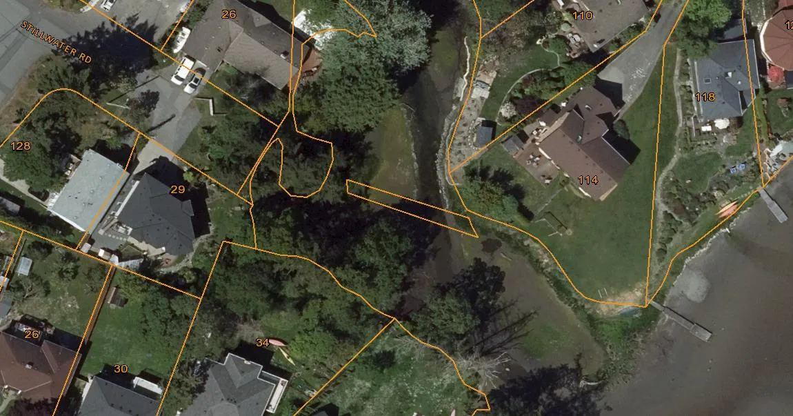
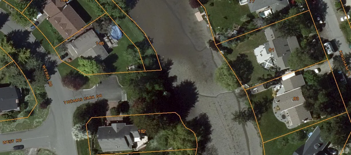
Thomas Road access to a narrow channel that is inaccessible due to summer low tides. It is just 370m away from Centennial Park trail and view points. 200m from Midwood road end.
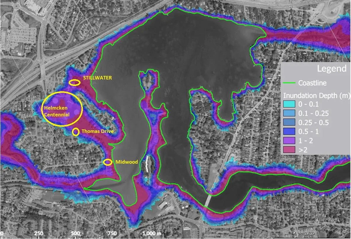
CRD Sea Level Rise projections (2020)
Prudent fiscal management says we should complete both the Coastal Adaptation Plan (N-089) and Centennial parks Master Plan first. The N-089 report shows tsunami risks to Esquimalt harbour / Millstream. Below shows the sea level rise predictions for Portage Inlet and implications to our parks, roads and sewer / storm water infrastructure. (CRD repot 2020)
IMPORTANCE OF PRESERVING CRITICAL NATURAL HABITATS (CONSULT WITH Gorge Waterways Initiative team). Information extract:
Victoria Harbour Migratory Bird Sanctuary
Victoria Harbour Migratory Bird Sanctuary (MBS) is located in urban Greater Victoria, near the southern tip of Vancouver Island, British Columbia. It is home to approximately 270 bird species including seabirds, waterbirds and shorebirds, notably in winter. This site supports over 75 species of animals and plants of federal and provincial conservation concern. It covers 30 km of Victoria's remarkable coastline and encompasses several unique natural areas.
Importance of the sanctuary: migratory birds and other wildlife
Victoria Harbour Migratory Bird Sanctuary, the first bird sanctuary in Pacific Canada, is located along a busy wildlife corridor around the southern tip of Vancouver Island, in Juan de Fuca Strait, in the heart of the Salish Sea. It lies in traditional Lekwungen (Songhees and Esquimalt First Nations) territory, in “the place to smoke herring”. It also lies next to five municipalities in the Capital Regional District of British Columbia (BC): Victoria, Oak Bay, Esquimalt, Saanich and View Royal.
This sanctuary provides critical habitat and is home for valuable wildlife including birds, fishes, mammals, molluscs, crustaceans, plants and other organisms including several federally designated species at risk. Though this sanctuary is located adjacent to a bustling city, it remains an important roosting and overwintering site for a large number of migratory bird species that use this vital habitat either seasonally or year-round.
Migratory Bird Sanctuaries, such as Victoria Harbour, are established for the protection and conservation of migratory birds. Whether these areas are used for feeding, resting or nesting, they play an important role in the survival of many species. Activities that could harm migratory birds, their nests or their eggs are prohibited. Portions of the MBS are designated as provincial ecological reserves and are not open to the public; they are governed by additional sets of regulations. Please ensure that you are aware of how you can help protect this sanctuary and please read the restrictions, including those on firearms and hunting, which are in place to conserve the wildlife that call it home. Dogs and cats must not be allowed to run at large inside Migratory Bird Sanctuaries.
Time to review the 2017 PARKS MASTER PLAN rationale and budget for “road ends”
- Sea level rise impacts was not on the radar in 2017… now it needs to be
- Victoria Migratory Bird Sanctuary is even more critical factor now
- Crane Place, Midwood, Price Road, Beaumont have been done
- Heddle / Tovey Crescent does need better kayak access
- What more is needed for Dukrill and Price Road (latter done recently)
- ADD View Royal pump station road end to the list of road ends.
- Stillwater and Thomas Road do not need any ecological restoration… natural as is.
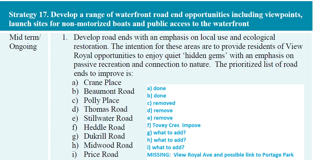
Strategy 17. Develop a range of waterfront road end opportunities including viewpoints, launch sites for non-motorized boats and public access to the waterfront
| Timing | Strategy Item | Status / Updates |
|---|---|---|
| Mid term/ Ongoing | 1. Develop road ends with an emphasis on local use and ecological restoration. The intention for these areas are to provide residents of View Royal opportunities to enjoy quiet ‘hidden gems’ with an emphasis on passive recreation and connection to nature. The prioritized list of road ends to improve is: a) Crane Place b) Beaumont Road c) Polly Place d) Thomas Road e) Stillwater Road f) Heddle Road g) Dukrill Road h) Midwood Road i) Price Road |
a) done b) done c) removed d) remove e) remove f) Tovey Cres improve g) what to add? h) what to add? i) what to add? MISSING: View Royal Ave and possible link to Portage Park |
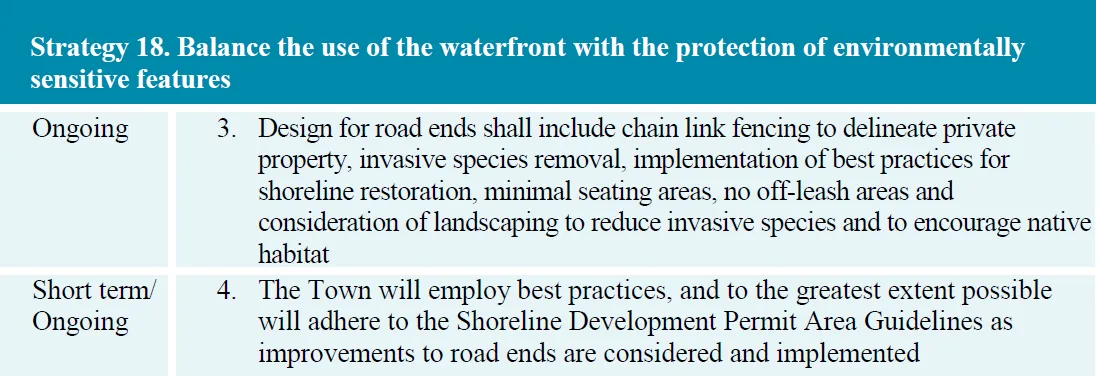
Strategy 18. Balance the use of the waterfront with the protection of environmentally sensitive features
| Timing | Strategy Item |
|---|---|
| Ongoing | 3. Design for road ends shall include chain link fencing to delineate private property, invasive species removal, implementation of best practices for shoreline restoration, minimal seating areas, no off-leash areas and consideration of landscaping to reduce invasive species and to encourage native habitat |
| Short term/ Ongoing | 4. The Town will employ best practices, and to the greatest extent possible will adhere to the Shoreline Development Permit Area Guidelines as improvements to road ends are considered and implemented |
From 2017 Parks Master Plan… 2 missing: Shoreline Drive and View Royal Ave.

Note: Since 2017 Plan, there have been significant developments. For example…
- Major development in Erskine / Watkiss area, calling for more park recreation space
- Atkins / 6 Mile / Chilco still does not have an off-leash amenity
- View Royal Park got a new playground, bike track plus toilet, drinking fountain
- Little Road ALR property was acquired
- Built two kayak access points; more toilets, and additional trails
John Roger, March 2, 2023