Geotechnical Review Report - New Access Stair and Dock, 302 Bessborough Avenue
A geotechnical assessment confirming the bedrock slope is suitable for the proposed construction and is free from global instability.
New Access Stair and Dock
302 Bessborough Avenue – View Royal, BC
Bayshore Planning Services Inc. 6499 Genoa Bay Road Duncan, BC V9L 5Y3
January 27, 2023 File No: 11517-1
Attn: Sharon Horsburgh (By E-mail: sharon@bayshoreplanning.com)
Re: New Access Stair and Dock 302 Bessborough Avenue – View Royal, BC
As requested, we attended the site on January 12th, 2023 to provide a geotechnical assessment of the slope at the foreshore for the proposed replacement of the shoreline access stairs and addition of a gangway for a private moorage. We understand the foreshore of the proposed site is located within the Town of View Royal Environmental Protection and Natural Hazard Development Permit Area (DPA) as per the Official Community Plan April 2011 and includes the upland and foreshore areas above and below and within 15 metres of the natural boundary of the sea. The following letter summarizes the results of our investigation and associated recommendations as related to the proposed development. Our work has been carried out in accordance with, and is subject to, the previously provided Terms of Engagement.
The site is located on the southeasterly facing shoreline within a small embayment on the Esquimalt Harbour. It is bounded by Bessborough Avenue to the northwest, by similar single family residential development to the northeast and southwest and by the shoreline to the southeast. The property is accessed by an asphalt surfaced driveway off Bessborough Avenue which leads to the main residence centrally located on the parcel. Behind the home there is a level area with a patio, wooden deck and several outdoor storage buildings. Beyond the rear level area shallow, grass and moss-covered bedrock continues for roughly 7 m to the crest of steep bedrock slopes above the foreshore.
The foreshore slope continues across the property line to the northeast for roughly 50 m and to the southwest for roughly 200 m. The subject slope is roughly 12 m high and comprised of bedrock with a cover of grass and moss. The lower 10 m of the slope is inclined at between 50 and 55 degrees from horizontal with some localized near vertical portions and some narrow benching near the base. The upper 2 m of slope is shallower and sloped at approximately 25 degrees from horizontal. The upper portion contains several bedrock benches roughly 0.5 m in height. Cemented stone stairs lead down to a wooden fence and gate at the slope crest. A wooden and metal railing fence provides a barrier to prevent access from this area to the steeper portion of the lower slope. We expect that there is a veneer of soil atop the bedrock in the upper portion of the slope, which vegetation is rooted in. There is a large conifer which resides near the slope crest with a vertical trunk (no pistol butting) indicating no surficial soil creep on the slopes and stability of such.
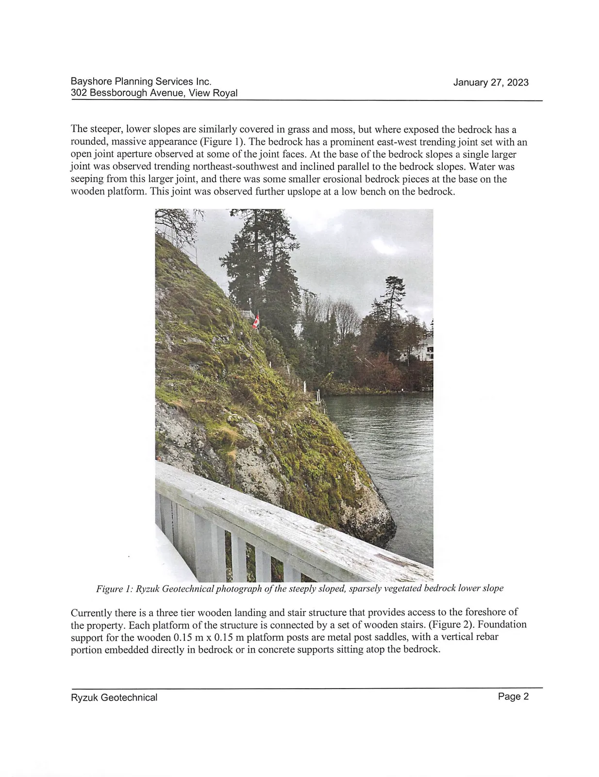
The steeper, lower slopes are similarly covered in grass and moss, but where exposed the bedrock has a rounded, massive appearance (Figure 1). The bedrock has a prominent east-west trending joint set with an open joint aperture observed at some of the joint faces. At the base of the bedrock slopes a single larger joint was observed trending northeast-southwest and inclined parallel to the bedrock slopes. Water was seeping from this larger joint, and there was some smaller erosional bedrock pieces at the base on the wooden platform. This joint was observed further upslope at a low bench on the bedrock.
Currently there is a three tier wooden landing and stair structure that provides access to the foreshore of the property. Each platform of the structure is connected by a set of wooden stairs. (Figure 2). Foundation support for the wooden 0.15 m x 0.15 m platform posts are metal post saddles, with a vertical rebar portion embedded directly in bedrock or in concrete supports sitting atop the bedrock.
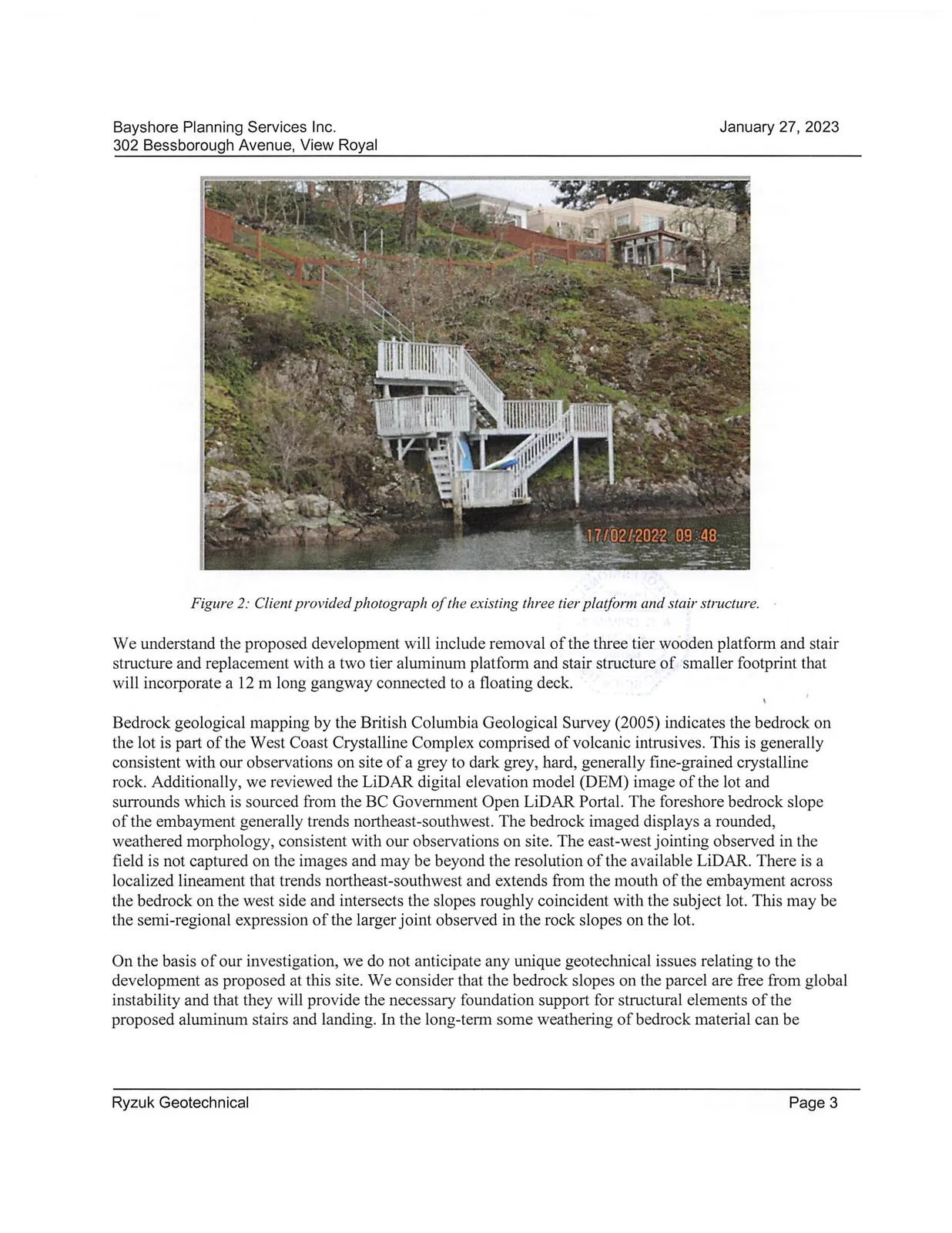
We understand the proposed development will include removal of the three tier wooden platform and stair structure and replacement with a two tier aluminum platform and stair structure of smaller footprint that will incorporate a 12 m long gangway connected to a floating deck.
Bedrock geological mapping by the British Columbia Geological Survey (2005) indicates the bedrock on the lot is part of the West Coast Crystalline Complex comprised of volcanic intrusives. This is generally consistent with our observations on site of a grey to dark grey, hard, generally fine-grained crystalline rock. Additionally, we reviewed the LiDAR digital elevation model (DEM) image of the lot and surrounds which is sourced from the BC Government Open LiDAR Portal. The foreshore bedrock slope of the embayment generally trends northeast-southwest. The bedrock imaged displays a rounded, weathered morphology, consistent with our observations on site. The east-west jointing observed in the field is not captured on the images and may be beyond the resolution of the available LiDAR. There is a localized lineament that trends northeast-southwest and extends from the mouth of the embayment across the bedrock on the west side and intersects the slopes roughly coincident with the subject lot. This may be the semi-regional expression of the larger joint observed in the rock slopes on the lot.
On the basis of our investigation, we do not anticipate any unique geotechnical issues relating to the development as proposed at this site. We consider that the bedrock slopes on the parcel are free from global instability and that they will provide the necessary foundation support for structural elements of the proposed aluminum stairs and landing. In the long-term some weathering of bedrock material can be expected but we consider that periodic inspection for such and routine maintenance will mitigate the associated risk.
We have not been provided detail of the structural design required for foundation elements to the proposed structure but expect that such may utilize similar support methodology, involving dowel and saddle connection or dowelled concrete footings upon approved bedrock. We can provide recommendations related to dowel installation and grouting as well as bearing resistance as needed.
We recommend that we review provided support at the time of design and we attend site at the time of construction once the vegetation has been removed, to assess the bedrock slopes for discontinuities or unfavorable jointing. We recommend that foundation elements be offset by a minimum of 1 m from the large joint observed near the base of the slopes behind the existing stairs. Additionally, stormwater disposal on the slope should be directed away from future footing locations.
We trust the preceding is suitable for your purposes at present. If you have any questions, or require anything further, please do not hesitate to contact us.
Yours very truly, Ryzuk Geotechnical
Tony Grimison, P.Geo. Intermediate Geoscientist
Scott Currie, P. Eng. Senior Review Engineer
Document Images
(2)