Appendix A. Private Recreational Dock Construction Plans and Section View
Detailed technical construction drawings including plan views, section views, and details for the existing and proposed dock structure.
Marine Habitat Review Esquimalt Harbour
Private Recreational Dock
August 2022
Bayshore Planning Services Inc. Storm Coast Diving
APPENDICES
Appendix A. Private Recreational Dock Construction Plans and Section View
Overall Plan View
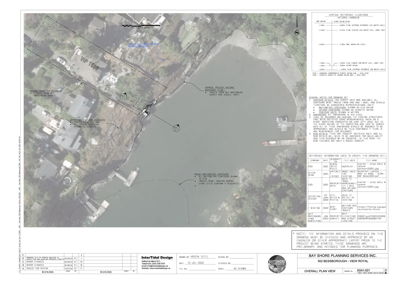
VERTICAL REFERENCE ELEVATIONS VICTORIA HARBOUR
| GSC DATUM | CHART DATUM (C+S) | |
|---|---|---|
| +1.90m | +3.80m | *EHWL (EXTREME RECORDED HIGH WATER LEVEL) |
| +1.20m | +3.10m | *HHWL (HIGHER HIGH WATER LEVEL, LARGE TIDE) |
| +0.00m | +1.90m | *MSL (MEAN SEA LEVEL) |
| -1.90m | -0.00m | *LLWL (LOWER LOW WATER LEVEL, LARGE TIDE) |
| -1.90m | -0.00m | *CHART DATUM |
| -2.40m | -0.50m | *ELWL (EXTREME RECORDED LOW WATER LEVEL) |
| *CHS = CANADIAN HYDROGRAPHIC SERVICE DATUM (LW. = 0.0m CHS) | ||
| *GSC = GEODETIC SURVEY OF CANADA DATUM (MSL = 0.0m GSC) |
GENERAL NOTES FOR DRAWING SET
- CONTOUR DETAILS: NO SURVEY DATA WAS AVAILABLE. ALL CONTOURS WERE TRACED FROM CRD AND I-BOAT, AND SHOULD THEREFORE BE CONSIDERED REPRESENTATIONAL ONLY:
- BATHYMETRIC CONTOURS: SHOWN AS CHS DATUM
- UPLAND CONTOURS: SHOWN AS GEODETIC DATUM
- CONTOUR UNITS: SHOWN IN METERS
- DIMENSIONS: ALL DIMENSIONS IN mm U.N.O.
- LEVEL OF ACCURACY ON EXISTING: THE EXISTING STRUCTURES HAVE BEEN SKETCHED USING MEASUREMENTS TAKEN ON A SHORT INSPECTION CONDUCTED ON JUNE 27TH 2022. DUE TO THE SHORT NATURE OF THE INSPECTION AND LACK OF SURVEY DATA ALL OF THESE DIMENSIONS SHOULD BE ASSUMED TO BE APPROXIMATE AND SHOULD BE FIELD CONFIRMED IF THERE IS ANY REQUIREMENT FOR ACCURACY.
- NEW DETAILS: THESE ARE CONCEPT SKETCHES ONLY, AND ALL NEW DETAILS WILL NEED TO BE ASSESSED FOR BUILD-ABILITY AND THEN DESIGNED BY AN ENGINEER... AT THIS POINT THE NEW FEATURES ARE ONLY A ROUGH CONCEPT.
REFERENCE INFORMATION USED TO CREATE THIS DRAWING SET:
| COMPANY | DATE | DESCRIPTION | FILE USED | FILE NAME |
|---|---|---|---|---|
| CRD | 2021 | AERIAL ORTHO PHOTO | UNDERLAY | overall - prop bdry & upland contour(2021).jpg |
| KEVIN SENN | 2021 | WATERLOT LICENCE | IMAGE USED FOR EXISTING TRACE | Waterlot Licence - 2021 to 2026 - SENN - 302 Bess(650).pdf |
| CRD | 2021 | PROPERTY DATA | APPROXIMATE LOT LINES AND UPLAND CONTOURS | overall - prop bdry & upland contour(2021).jpg |
| INTERTIDAL DESIGN | 27 JUNE 2022 | SITE NOTES & PHOTOS | USED TO SKETCH IN EXISTING | |
| I BOATING | 2022 | BOAT CHART | BATHYMETRIC CONTOURS TRACED | https://fishing-app.gpsnauticalcharts.com |
| WEY MAYENBURG LAND SURVEYING | JAN 2023 | PROPERTY SURVEY | ELEVATIONS AND STRUCT. LOCATING | 230007.jan272023.23038430092993560801.PDF |
- NOTE: THE INFORMATION AND DETAILS PROVIDED ON THIS DRAWING MUST BE CHECKED AND APPROVED BY AN ENGINEER OR OTHER APPROPRIATE EXPERT PRIOR TO THE PROJECT BEING STARTED. THESE DRAWINGS ARE PRELIMINARY, AND INTENDED FOR PLANNING PURPOSES.
BAY SHORE PLANNING SERVICES INC. 302 BESSBOROUGH - VIEW ROYAL Drawing No.: K041-001 Revision: D
Plan View - Exist. Details
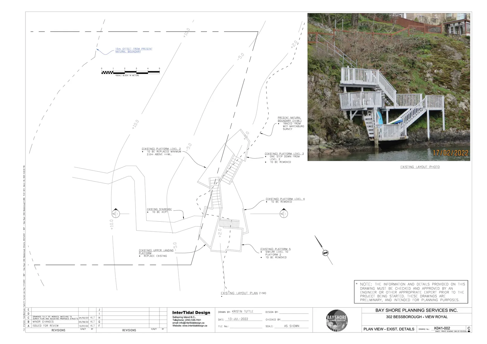
- NOTE: THE INFORMATION AND DETAILS PROVIDED ON THIS DRAWING MUST BE CHECKED AND APPROVED BY AN ENGINEER OR OTHER APPROPRIATE EXPERT PRIOR TO THE PROJECT BEING STARTED. THESE DRAWINGS ARE PRELIMINARY, AND INTENDED FOR PLANNING PURPOSES.
BAY SHORE PLANNING SERVICES INC. 302 BESSBOROUGH - VIEW ROYAL Drawing No.: K041-002 Revision: C
Existing Section at A-A
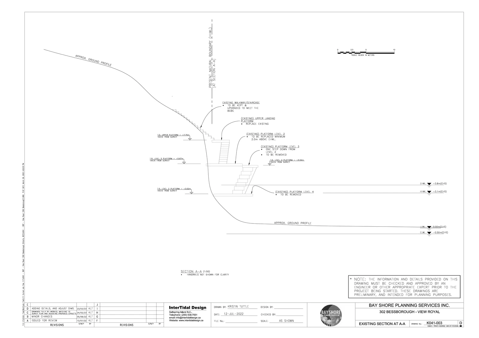
SECTION A-A (1:50)
HANDRAILS NOT SHOWN FOR CLARITY
NOTE: THE INFORMATION AND DETAILS PROVIDED ON THIS DRAWING MUST BE CHECKED AND APPROVED BY AN ENGINEER OR OTHER APPROPRIATE EXPERT PRIOR TO THE PROJECT BEING STARTED. THESE DRAWINGS ARE PRELIMINARY, AND INTENDED FOR PLANNING PURPOSES.
BAY SHORE PLANNING SERVICES INC. 302 BESSBOROUGH - VIEW ROYAL Drawing No.: K041-003 Revision: D
Plan View - New Details
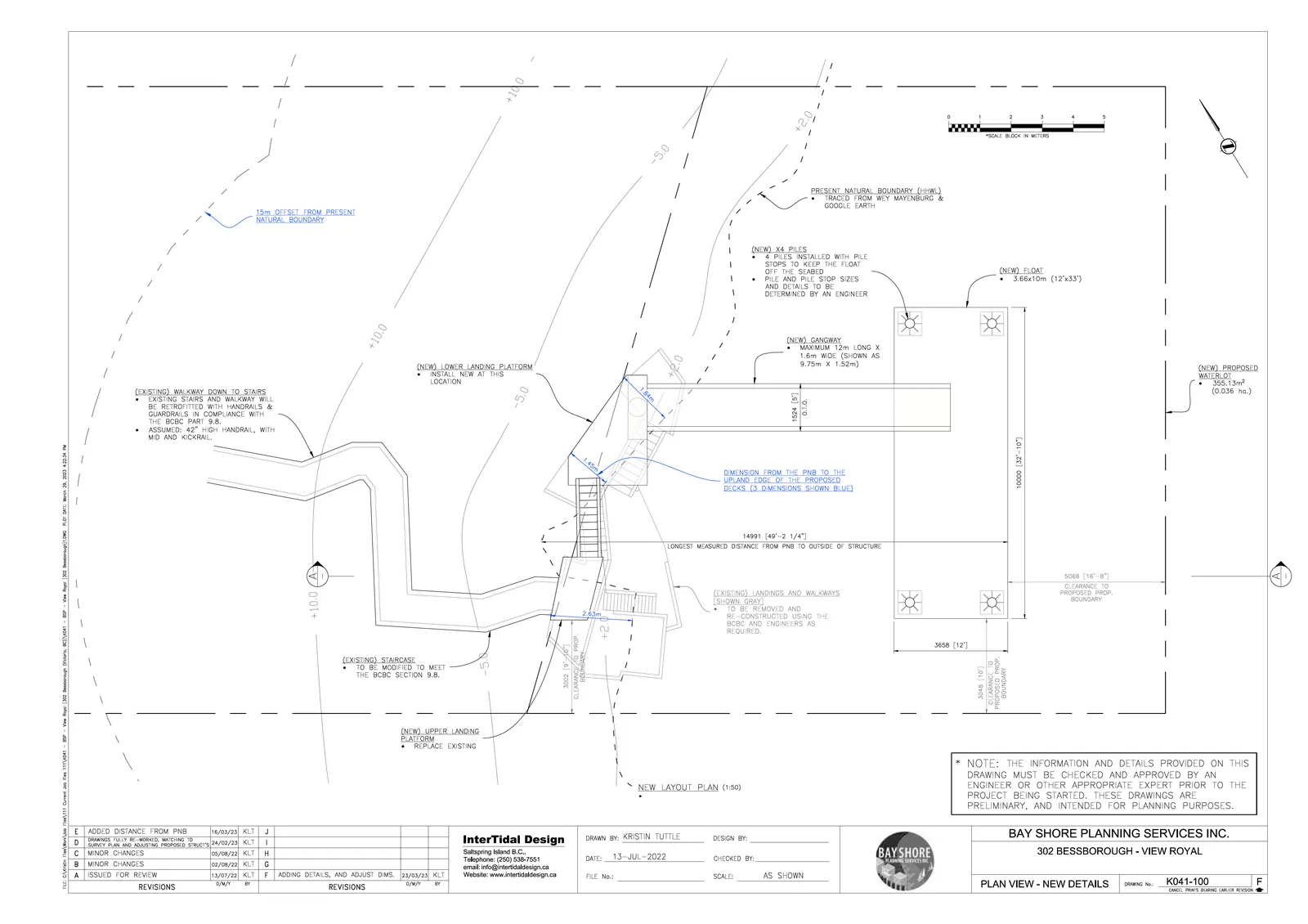
PROPOSED DIMENSIONS:
- (NEW) GANGWAY: MAXIMUM 12m LONG X 1.6m WIDE (SHOWN AS 9.75m X 1.52m)
- (NEW) FLOAT: 3.66x10m (12'x33')
- (NEW) PROPOSED WATERLOT: 355.13m² (0.036 ha.)
- LONGEST MEASURED DISTANCE FROM PNB TO OUTSIDE OF STRUCTURE: 14991 [49'-2 1/4"]
- CLEARANCE TO PROPOSED PROP. BOUNDARY: 5068 [16'-8"]
- DIMENSION FROM THE PNB TO THE UPLAND EDGE OF THE PROPOSED DECKS (3 DIMENSIONS SHOWN BLUE): 1.84m, 1.45m, 2.63m.
EXISTING TO BE REMOVED/MODIFIED:
- EXISTING LANDINGS AND WALKWAYS (SHOWN GRAY) TO BE REMOVED AND RE-CONSTRUCTED USING THE BCBC AND ENGINEER'S AS REQUIRED.
- EXISTING STAIRCASE TO BE MODIFIED TO MEET THE BCBC SECTION 9.8.
- EXISTING WALKWAY DOWN TO STAIRS WILL BE RETROFITTED WITH HANDRAILS & GUARDRAILS IN COMPLIANCE WITH THE BCBC PART 9.8. ASSUMED: 42" HIGH HANDRAIL, WITH MID AND KICKRAIL.
BAY SHORE PLANNING SERVICES INC. 302 BESSBOROUGH - VIEW ROYAL Drawing No.: K041-100 Revision: F
New Section at A-A
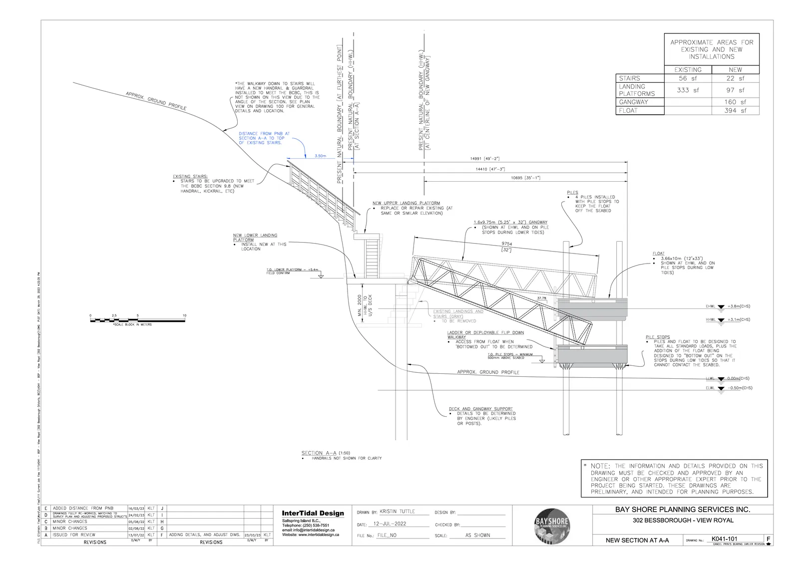
APPROXIMATE AREAS FOR EXISTING AND NEW INSTALLATIONS
| EXISTING | NEW | |
|---|---|---|
| STAIRS | 56 sf | 22 sf |
| LANDING PLATFORMS | 333 sf | 97 sf |
| GANGWAY | 160 sf | |
| FLOAT | 394 sf |
CONSTRUCTION NOTES:
PILES: 4 PILES INSTALLED WITH PILE STOPS TO KEEP THE FLOAT OFF THE SEABED.
FLOAT: 3.66x10m (12'x33'). SHOWN AT THWL AND ON PILE STOPS DURING LOW TIDES.
PILE STOPS: PILES AND FLOAT TO BE DESIGNED TO TAKE ALL STANDARD LOADS, PLUS THE ADDITION OF THE FLOAT BEING DESIGNED TO "BOTTOM OUT" ON THE STOPS DURING LOW TIDES SO THAT IT CANNOT CONTACT THE SEABED. T.O. PILE STOPS = MINIMUM 500mm ABOVE SEABED.
LADDER: LADDER OR DEPLOYABLE FLIP DOWN WALKWAY. ACCESS FROM FLOAT WHEN "BOTTOMED OUT" TO BE DETERMINED.
GANGWAY: 1.6x9.75m (5.25" x 32') GANGWAY (SHOWN AT EHWL AND ON PILE STOPS DURING LOWER TIDES).
SECTION A-A (1:50): HANDRAILS NOT SHOWN FOR CLARITY.
NOTE: THE INFORMATION AND DETAILS PROVIDED ON THIS DRAWING MUST BE CHECKED AND APPROVED BY AN ENGINEER OR OTHER APPROPRIATE EXPERT PRIOR TO THE PROJECT BEING STARTED. THESE DRAWINGS ARE PRELIMINARY, AND INTENDED FOR PLANNING PURPOSES.
BAY SHORE PLANNING SERVICES INC. 302 BESSBOROUGH - VIEW ROYAL Drawing No.: K041-101 Revision: F