Town of View Royal Active Transportation Network Plan
A comprehensive strategic plan outlining the Town's 10-year roadmap for improving pedestrian and cycling infrastructure, including roles for an AT Coordinator.
...successful and timely implementation and coordination of active transportation improvements. The full time Active Transportation Coordinator position is envisioned to encompass the following:
- Serve as the public face to AT efforts
- Coordinate ATNP improvements
- Review designs to improve AT accommodation
- Oversee bike parking improvements and code updates
- Oversee education and encouragement efforts
- Oversee monitoring and deliver progress updates to Council
- Coordinate Active Transportation planning and improvements with regional partners including BC Transit
- Project manage active transportation improvements
If the Town is not able to fund a dedicated Active Transportation Coordinator position, then consideration should be given to a more general position within the Town’s engineering department. The staff member could have active transportation responsibilities in their job description and provide additional support to the department based on current and future priorities.
5.5.4 Amenities
Public Bike Parking
The provision of convenient, safe and secure bicycle parking is critical to ensure the successful use of cycling as a viable mode of transportation, as research has shown that a lack of appropriate bicycle parking is one of the primary deterrents in adoption and ongoing use. Bicycle parking can be categorized as either short-term or long-term, and it is important to note that not all bicycle parking is equally sufficient - factors such as supply, location, comfort, and design will determine whether end-point facilities are adequate for users’ needs. The BC Active Transportation Guide lists the key guiding principles for the development of a high-quality bicycle parking program:
- Convenience: Provision of bicycle parking in convenient and intuitive locations, adjacent to key destinations. Weather protection should be provided when possible to encourage all-weather cycling.
- Safety and Secure: Bicycle parking should be securely installed to the pavement and be located in well-lit and highly-visible locations.
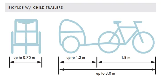
- Functional: Bicycle parking should consider different bicycle types, including cargo bicycles, bicycles with trailers, etc. Clearance from buildings, street furniture, vegetation, and other bicycle racks should be considered so that the design is intuitive and functional. Bicycle racks should be oriented so that bicycles are positioned parallel to the curb.
- Accessible: Bicycle parking should not become an obstacle to other users, including pedestrians and motor vehicles. Bicycle racks must be placed within the furnishing zone allowing for a wide pedestrian through zone so that they do not become a barrier to people using mobility aids, and must be easily detectable by visually impaired people. Bicycle parking spaces should be located close or within fire zones, loading zones, bus zones, passenger loading zones, accessible on-street parking spaces, or any other area where pedestrian will require frequent access.
- Aesthetics: Bicycle parking can match the design of the surrounding streetscape, however design functionality must be prioritized over aesthetic appeal.
Short-Term Bike Parking
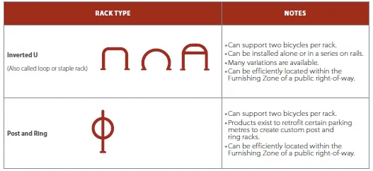
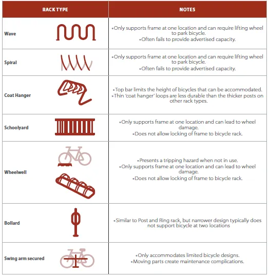
Short-term bike parking is appropriate for use in public spaces, such as on streets within commercial or retail areas, or adjacent to facilities and services that are typically used for a short time (up to 4 hours), such as gymnasiums, libraries, healthcare facilities and other civic services. Rack selection for short-term bike parking is important, and the BC Active Transportation Design Guide recommends the ‘Inverted U’ and ‘Post and Ring’ rack types due to their universal application and sound design. Conversely, there are several rack types that are frequently used that do not meet performance criteria for a variety of reasons and are to be avoided (as shown in the image at-right).
Non-Standard Bike Parking Considerations
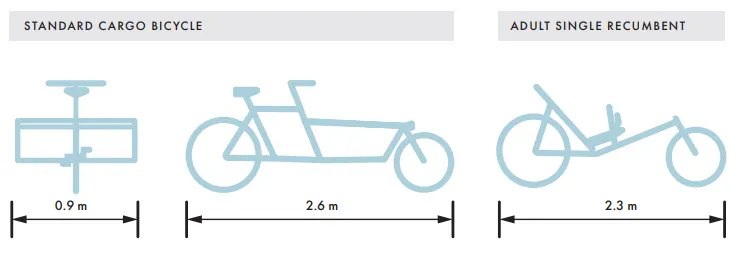
There are several emergent forms of non-standard bicycle that are now in frequent use across the Capital Regional District (including the Town of View Royal), such as cargo bikes, bicycle rickshaws, recumbent bikes, etc. These bicycles are typically longer, wider, and heavier than standard bicycles and are not always compatible with traditional bike racks. The BC Active Transportation Design Guide does not recommend that racks for non-standard bicycle parking be installed for on-street use, but are better placed within covered bicycle shelters, parkades, or outside community facilities.
Bike Parking Retrofit Program
Based on the design guidance outlined above, it is recommended that the Town of View Royal establish a bike parking retrofit program. The purpose of the program is two-fold: (1) allow the Town to retrofit, over time, all of its municipally-owned short-term bike parking to align with the BC Active Transportation Design Guide and (2) work with business and commercial property owners to encourage them to install or retrofit short-term bike parking to align with best practices. The Town will need to explore to incentive approaches to help get buy-in from the private sector, which could include tax breaks or other financial mechanisms.
Wayfinding
Wayfinding refers to all of the infrastructure and systems associated with helping individuals to correctly orient themselves within their environment and conveniently reach their intended destination. Wayfinding enables better trip planning and can reduce fear associated with navigating complex urban environments, thereby encouraging broader participation in active transportation from a wider range of users. Wayfinding can also be used to encourage exploration, by increasing awareness of services, supportive infrastructure, and other points of interest along a route.
The BC Active Transportation Design Guide contains recommendations for the design and placement of wayfinding signage to address the needs of both pedestrians and cyclists, as these differ considerably.
Pedestrian Recommended Wayfinding:
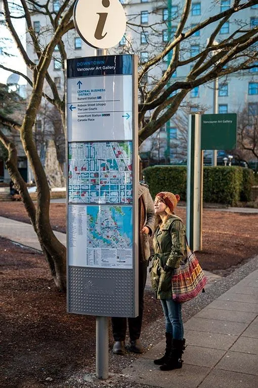
Pedestrian Monoliths (large or small) – These typically contain a considerable amount of information featured on a map of the immediate surroundings, and sometimes include additional maps at differing scales detailing the larger area beyond. Monoliths should identify a myriad of different landmarks relevant for different user groups, accompanied by directions and accessibility aids. Monoliths work best in more urban settings, such as plazas or other open spaces, as they have the capacity to convey more information than other types of wayfinding signage.
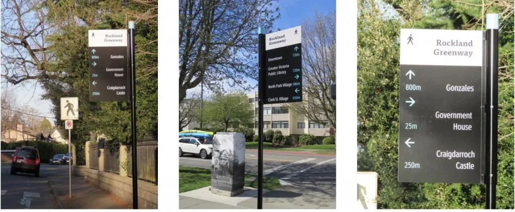
Pedestrian Fingerposts – These are typically used when it is more appropriate to provide simple directional information to limited points of interest, and work best in less dense areas where a map would be excessive.
Pedestrian Wayfinding Placement
The BC Active Transportation Design Guide recommends the following criteria for placement of pedestrian wayfinding signage:
- On streets with high levels of pedestrian traffic.
- At intersections or junction points to help with route decision-making.
- Where there is lighting to ensure the information is readable in darker conditions and in the winter months.
Cycling Recommended Wayfinding:
Decision Signage – Used on the approach to a ‘decision point’, which could present as an intersection or deviation along a path. Decision signage is used to indicate the most effective path to one or several points of interest using simple directional arrows.
Confirmation Signage – Used after a decision point, and at regular intervals along a given path to confirm that an active transportation user is travelling in the right direction to reach their destination.
Special Situation Signage – Varied signage used in specific circumstances to navigate complex or confusing areas.
It is recommended that the Township develop a dedicated wayfinding strategy to determine specific contextual requirements for pedestrian and cycling wayfinding in View Royal.
5.5.5 Maintenance
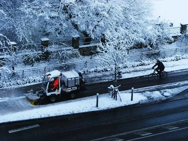
Active transportation facilities, like roads, must be maintained to facilitate travel. And even though View Royal—and Greater Victoria more broadly—does not see the same levels of snow as other parts of Canada, there are still hazards that impact the ability for one to use a sidewalk or cycling facility including glass or debris, potholes and cracked surfaces, and leaves, for example.
The Town currently has a street and sidewalk maintenance program. This includes routine maintenance of street light and traffic light repairs, street sign repairs, sidewalk maintenance, pothole repairs, street sweeping, ice and snow clearing, and ditch and boulevard maintenance. What is currently missing, however, is maintenance of existing cycling facilities.
Therefore, as the Town looks to implement the short-term priority projects outlined in the ATNP, it should ensure a robust maintenance program is in place that includes maintenance of all active transportation facilities. This includes:
- Sweeping and removing gravel, debris, and leaves; trimming adjacent vegetation; and adjusting bollards and other elements related to protected bike lane delineators.
- In the fall and winter months, it is critical to clear and remove debris and snow
- and treat and remove ice or slippery conditions.
- There are also asset management activities, which can include repairing pavement surfaces and other road surface appurtenances such as utility covers; replacing worn pavement markings, signs, and signals; mitigating locations with pooling water or drainage issues; replacing broken delineators; maintaining street and path lighting; and repairing and maintaining equipment that is used to maintain cycling facilities.
5.5.6 Policies & Bylaws
Speed Limit Establishment Policy
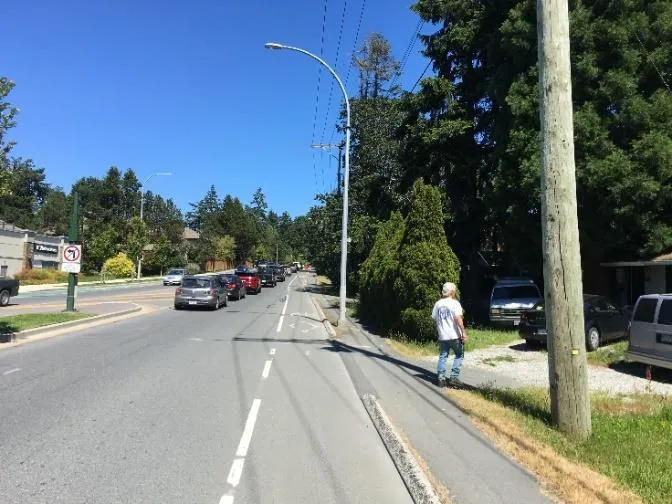
As outlined in the View Royal ATNP Baseline Conditions Report, vehicle speed limits are important to understand as they impact the overall comfortability of active users. While higher speeds do not necessarily cause collisions to occur, higher speeds do result in more severe collisions particularly for vulnerable road users. By contrast, lower speeds can give vehicle drivers more time and greater control, which improves road safety and lower the overall impact if a collision does occur.¹⁸ Therefore, understanding posted and operating speed limits—and where they differ in the street network—can help inform the types of activity transportation facilities that could be considered.
Feedback from the open house
Several of the open house participants noted that vehicle speeding continues to be a major concern. Participants would like the Town to focus on reducing posted speed limits on residential / collector roads to make active transportation more comfortable for all users.
Within the capital region and across BC, municipalities are undertaking different approaches to address concerns about the speed travelled on streets including “speeding” and road safety more broadly. “Vision Zero”, which is a strategy focused on eliminating all traffic fatalities and severe injuries while increasing safe, health, equitable mobility for all, is one key initiative in looking at the relationship of speed and safety. A summary of different approaches on adjusting posted speed limits is provided below:
- City of Victoria | all local streets in the City are going to change from 50 km/h to 30 km/h. Reducing the posted speed limit from the provincial default speed of 50 km/h to 30 km/h will require significant new signage to legally set the posted speed limit. The City’s program, which will be rolled out in May 2023, will be implemented on a neighbourhood-by-neighbourhood basis starting with the Hillside Quadra neighbourhood.
- District of Saanich | the District adopted a Speed Limit Establishment Policy in July 2022. The policy provides guidance for staff to determine the appropriate speed limits on all streets under Saanich’s jurisdiction and control. The policy identifies two categories of streets: Type A streets are streets without continuous yellow centre lines and/or streets where a Neighbourhood Bikeway exists or is proposed in the District’s Active Transportation Plan. All Type A streets would have a maximum speed limit of 30 km/h. Type B streets have a continuous yellow centre line and/or streets that are not in the Type A Streets category. As of April 2023, the District has approved the speed limit reduction on nine priority corridors where the speed limit will be reduced from 50 km/h to 40 km/h or 30 km/h depending on the road.
- Township of Esquimalt | The Township is currently in the process of considering reduced speed limits on Major Roads to 40 km/h with all other roads to 30 km/h. Both Admirals Road and Craigflower Road, which connect to View Royal, are proposed to be posted at 40 km/h. The Township is planning to install new speed limit signs over the next year starting with its “gateways” and major roads.
All three municipalities above are taking a slightly different approach to changing posted speed limits to try to address speeding and road safety. The pros / cons of each are hard to assess as each program / policy is in its preliminary stages and lessons learned will be available over time. One key lesson that will be important to consider / understand is the actual impact that changing posted speed limits alone has on driver speeds. Changing driver behaviours often requires more than just signage and paint. Therefore, blanket policies without consideration for type of street, street function, adjacent land use, and lane / street width may not yield the desired outcomes of safer and more comfortable roads for all users.
Posted vs. Operating Speeds
Posted speed limits are the maximum speed drivers are permitted to travel on the road in ideal conditions.
Operating speeds are based on the 85th percentile speed of actual drivers. Drivers use inputs including lane width, width of corridor, proximity to hazards, adjacent land use, and other visual cues to determine their ‘comfortable’ speed on a street. This speed may not match the posted speed limit.
That said, it is recommended that the Town of View Royal explore the development of a Speed Limit Establishment Policy. It would be intended to provide an overall framework to help staff determine the appropriate posted speed limits on all streets under the Town’s jurisdiction and control.
It is recommended that the Speed Limit Establishment Policy consider the following:
- All local streets within the Town—without a continuous yellow centre line—could have a default posted speed limit of 30 km/h.
- The Town’s arterial roads and/or collector roads could be considered for a lower speed limit of 40 km/h. This could be determined by: a. A safe speed study, which would rely on a technical analysis of existing speeds and assessment of street geometry, street widths (with and without parking utilized), and adjacent land uses to determine the posted speed limit.
- Consider reducing the speed on all corridors / streets where a short-term priority project has been identified (as outlined in Section 5.4.1 and 5.4.2), as a trial to determine if lower posted speeds reduce operating speeds and improve comfort / safety for active transportation users (both real and perceived).
Bicycle Parking Zoning Bylaw Amendment
The Town’s Zoning Bylaw has requirements for bicycle parking including both “Class 1” and “Class 2”. The bylaw also includes a requirement that all Class 1 bicycle parking spaces be energized to facilitate charging. Beyond these regulations, the bicycle parking requirements fall short of best practices.
Given the importance of bicycle parking to the success of any active transportation network, it is recommended that the Town update its Zoning Bylaw to align with best practices and the guidance outlined in the BC Active Transportation Design Guide.
Some specific considerations that should be referred to within an update include:
- Long-term & Short-term Bicycle Parking: Replace the terminology “Class 1 and Class 2” bike parking. The following definitions could be adopted:
- Long-term Bicycle Parking | also referred to as “Class A” or “Class I” bicycle parking, this refers to a secure weather protected bicycle parking facility used to accommodate long-term parking, such as for residents or employees, usually within a room or covered, fenced area.
- Short-term Bicycle Parking | also referred to as “Class B” or “Class II” bicycle parking, this refers to a short-term visitor bicycle parking facility, which may offer some security and be partially protected from the weather.
- Refer to the BC Active Transportation Design Guide for direction on type, material, and layout of bicycle parking – it is a comprehensive document that details best practices for location and accessibility, and can be adapted for local context.
- Plan for non-standard bicycle configurations: Given the rapid uptake of non-standard (or oversized) bicycles, it is imperative that they be planned for and factored into any amendment to the Zoning Bylaw, as they have storage requirements that are generally not addressed by standard bicycle parking facilities. The Capital Region Local Government Electric Vehicle + Electric Bike Infrastructure Planning Guide contains specific parking guidelines for e-bikes, and the BC Active Transportation Design Guideline provides guidance for other forms of non-standard bicycles – based on these two documents, in general the following should be considered:
- Oversized (or non-standard) bike parking spaces should have a minimum distance of 3.0m in length and 0.9m in width.
- At least 10% of the required long-term and short-term bicycle parking spaces should be designed as oversized spaces.
- All oversized bike parking spaces should be provided as ground anchored racks. Oversized bicycles, especially electric cargo bikes, are heavy, long, and challenging to park in a vertical bike rack.
- At least 50% of the required long-term oversized bike parking spaces should have access to a 110V wall receptable for charging.
- Provide for cycling end-of-trip facilities: Many communities have adopted specific requirements for the provision of end-of-trip facilities that contribute to the comfort of active transportation users, such as showers, change rooms, personal lockers, and bike maintenance stations. It is recommended that the Town of View Royal consider making the provision of such facilities a requirement where appropriate.
6.0 IMPLEMENTATION STRATEGY
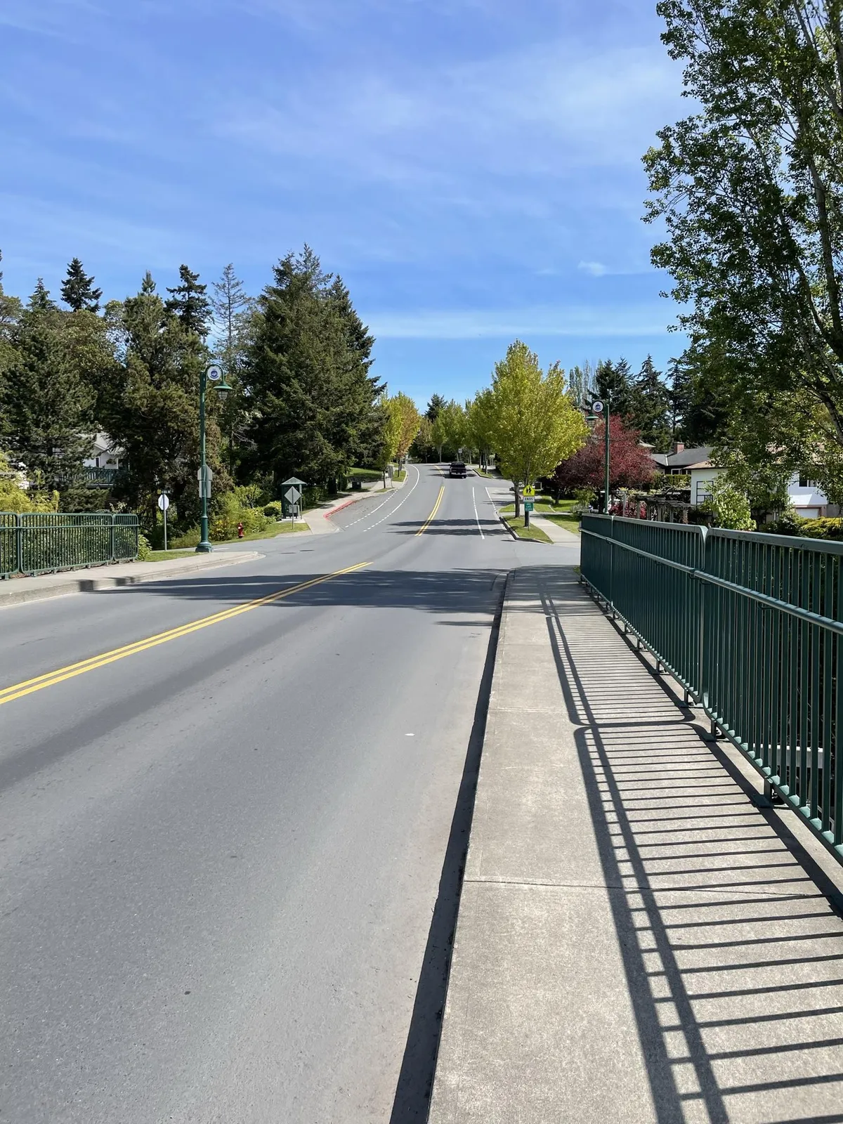
The implementation strategy includes details on the cost estimates for the short-term projects, an overall action plan for each of the recommendations in the ATNP, and the different funding opportunities available to pay for the facility improvements.
6.1 Short-term Priority Capital Projects
Table 10 below provides an order of magnitude (Class D)¹⁹ cost estimate for all the short-term infrastructure improvements identified in Section 5.4. The cost estimates are based on concept level information using unit rates for linear works and improvements. The actual costs for implementation for each project could vary and will be confirmed through additional engagement and the detailed design stage. The total level of investment for the short-term projects is approximately $11,013,200.
Table 10. Short-term Project Cost Estimates
| Action ID & Project Name | Class D Cost Estimate (2023 $) |
|---|---|
| 1A Admirals Road (Island Hwy to Hallowell Rd) | $3,742,300 |
| 1B Island Highway (E&N Rail Trail to Admirals Rd) | $335,000 |
| 1C Helmcken Interchange (Watkiss Way to Vickery Rd) | $1,973,500 |
| 1D Helmcken Road (Watkiss Way to Burnside Rd) | $1,166,500 |
| 1E Watkiss Way (roundabout to Helmcken Rd) | $893,600 |
| 1F Burnside Road (Helmcken Rd to Saanich border) | $414,600 |
| 1G Vickery Road / St. Giles Road | $73,000 |
| 1H Six Mile Road (Island Hwy to Thetis Lake) | $1,037,800 |
| 1I Jedburgh Road (12 Jedburgh Rd to Helmcken Rd) | $192,100 |
| 1J Chancellor Avenue (Helmcken Rd to Galloping Goose Regional Trail) | $447,800 |
| 1K Glentana Road (Island Hwy to Admirals Rd) | $365,600 |
| 1L Talcott Road (Galloping Goose Regional Trail to Eagle View Elementary) | $193,400 |
| 1M Island Highway (Wilfret Rd to Hart Rd) | $178,000 |
| Total | $11,013,200 |
¹⁹ Class D (2023 dollars) cost estimates are based on concept level information using unit rates for linear works and intersection improvements. Cost estimates include 25% engineering and communications as well as 50% contingency. Cost do not include property and other significant impacts. Class D cost estimates should not be used for budgeting purposes.
6.2 Action Plan
Table 11 includes the action plan for the 37 recommended actions, which is organized into four distinct categories, as follows:
- Active Transportation Facilities
- Intersection Improvements
- Bus Stop Upgrades
- Programs + Policies
Each action is guided by the following:
- Timeframe | The immediate term refers to 1-3 years; short to medium-term is 3-7 years; and long-term refers to 7-10 years. The overall prioritization of the action(s) may change over time due to shifting priorities at the Town. The timeframe outlined below should serve as the guiding framework to help the Town with project planning and capital planning.
- Partners | The Town of View Royal is responsible for the majority of actions but collaboration with other organizations / stakeholders.
- Implementation Approach | There are different ways to implement an action including (1) capital project; (2) operational / maintenance; (3) technical study; (4) policy / regulatory; and (5) education / programming / advocacy.
Table 11. ATNP Action Plan Summary
| Action | Timeframe | Partners | Implementation Approach |
|---|---|---|---|
| Active Transportation Facilities | |||
| 1A Implement Admirals Road pedestrian and cycling facilities from Island Hwy to Hallowell Rd | Immediate | MOTI | Capital project |
| 1B Implement Island Highway off-street multi-use pathway from E&N Rail Trail to Admirals Rd | Short-medium | Shoreline Middle School | Capital project |
| 1C Implement Helmcken Interchange pedestrian and cycling facilities from Watkiss Way to Vickery Rd | Short-medium | MOTI | Capital project |
| 1D Implement Helmcken Road (multiple improvements) from Watkiss Way to Burnside Rd) | Immediate | N/A | Capital project |
| 1E Implement Watkiss Way cycling facilities from roundabout to Helmcken Rd | Short-medium | N/A | Capital project |
| 1F Implement Burnside Road sidewalk facilities from Helmcken Rd to Saanich border | Immediate | District of Saanich | Capital project |
| 1G Implement Vickery Road / St. Giles Road bicycle boulevard | Immediate | N/A | Capital project |
| 1H Implement Six Mile Road multi-use pathway from Island Hwy to Thetis Lake | Immediate | N/A | Capital project |
| 1I Implement Jedburgh Road sidewalk facilities from 12 Jedburgh Rd to Helmcken Rd | Immediate | N/A | Capital project |
| 1J Implement Chancellor Avenue pedestrian and cycling facilities from Helmcken Rd to Galloping Goose | Short-medium | Capital Regional District (CRD) | Capital project |
| 1K Implement Glentana Road multi-use pathway | Short-medium | N/A | Capital project |
| 1L Implement Talcott Road multi-use pathway from Galloping Goose to Eagle View Elementary | Short-medium | Eagle View Elementary | Capital project |
| 1M Implement Island Highway sidewalk facilities | Immediate | N/A | Capital project |
| Intersection Improvements (Major) | |||
| 2A Conduct intersection review of Burnside Road W / Helmcken Road | Immediate | District of Saanich | Technical study |
| 2B Conduct intersection review of Helmcken Road / Watkiss Way | Immediate | MOTI | Technical study |
| 2C Conduct intersection review of Helmcken Road / Island Highway | Immediate | N/A | Technical study |
| 2D Conduct intersection review of Admirals Road / Island Highway | Immediate | Township of Esquimalt, MOTI | Technical study |
| 2E Conduct intersection review of Admirals Road / Hallowell Road | Immediate | Township of Esquimalt, MOTI | Technical study |
| Intersection Improvements (Minor) | |||
| 2F Conduct review of Galloping Goose Regional Trail / Talcott Road crossing | Short-medium | CRD | Technical study |
| 2G Conduct review of Galloping Goose Regional Trail / Atkins Road crossing | Short-medium | CRD | Technical study |
| 2H Conduct review of E&N Rail Trail / Burnett Road crossing | Short-medium | CRD | Technical study |
| 2I Conduct review of E&N Rail Trail / Adams Place | Immediate | CRD | Technical study |
| 2J Conduct review of Galloping Goose Regional Trail / Camden Avenue crossing | Short-medium | CRD | Technical study |
| 2K Conduct review of E&N Rail Trail / Island Highway / Colwood Interchange | Immediate | CRD, MOTI | Technical study |
| Bus Stop Upgrades | |||
| 2L Work with BC Transit to upgrade six bus stops within the Town with more passenger amenities | Immediate | BC Transit | Capital project |
| Programs & Policies | |||
| 3A Continue to support and promote the Ready, Step, Roll program | Immediate | CRD | Education / programming / advocacy |
| 3B Support bicycle skills training | Short-medium | Capital Bike | Education / programming / advocacy |
| 3C Support Bike to Work/School Week | Immediate | Capital Bike | Education / programming / advocacy |
| 3D Develop a standalone active transportation page on Town website | Immediate | N/A | Education / programming / advocacy |
| 3E Develop an “Amazing Places” walking tour | Immediate | N/A | Education / programming / advocacy |
| 3F Advocate for regional trail widening | Short-medium | CRD | Education / programming / advocacy |
| 3G Hire an active transportation coordinator | Immediate | N/A | Operational / maintenance |
| 3H Bike parking retrofit program | Short-medium | N/A | Policy / regulatory |
| 3I Undertake wayfinding strategy | Short-medium | N/A | Technical study |
| 3J Maintain active transportation network | Ongoing | N/A | Operational / maintenance |
| 3K Explore the development of a Speed Limit Establishment Policy | Short-medium | West Shore RCMP | Policy / regulatory & Technical study |
| 3L Update bicycle parking requirements in zoning bylaw to reflect best practices | Immediate | N/A | Policy / regulatory |
6.3 Funding Opportunities
The projected cost for the short-term priority projects is $11,013,200. Even though this represents a significant cost for the Town, active transportation infrastructure represents fraction of the costs associated with traditional road infrastructure. There are multiple ways the Town could pay for its new active transportation infrastructure including through its own municipal budget, through the development process, and provincial / federal grants.
6.3.1 Capital Planning
The Town’s current Financial Plan (2022-2026) supports the enhancement of livability in View Royal through investments in roads, parks and trails, fire services equipment, and technology. The Town revisits and updates its Financial Plan each year based on emerging and shifting priorities. As identified in the 2022-2026 Financial Plan, close to 44% of total capital spending is funded from Casino revenue or Community Works funds reserve funds.
According to the Financial Plan, a total of $11,301,650 has been allocated to transportation for several improvements including pedestrian lighting improvements, new sidewalks, intersection and roundabouts, and general roadway improvements. The Town should revisit the capital plan transportation budget in its existing Financial Plan and reallocate funding for the short-term priority projects identified in Section 5.4. Further, each of the short-term priority projects should be considered in the Town’s subsequent Financial Plan to ensure they are not lost.
6.3.2 Private Development
As the Town continues to grow, it will be important to leverage active transportation investments during the planning of new development projects. For example, there are several growth areas identified in the Town’s OCP Land Use Designation map where additional residential and commercial density is encouraged including (1) Commercial, (2) Neighbourhood Mixed Use, and (3) Intensive Mixed Use. The Town has the ability, through bylaws and policies, to request financial contributions for active transportation infrastructure including sidewalks, cycling facilities, and multi-use pathways.
For all new development applications along roads where an active transportation facility has been recommended (either in the short-term or ultimate networks), the Town should refer the applicant to the design guidelines as outlined in Section 5.3 and request a financial contribution to build part of the facility as part of frontage and roadway improvements.
6.3.3 BC Active Transportation Infrastructure Grant Program
The B.C. Active Transportation Infrastructure Grants Program offers two grant options for Indigenous governments and local governments, including municipalities, regional districts, and Islands Trust. Specifically, the Active Transportation Infrastructure Grant allows eligible governments to apply for a maximum of two grants if they satisfy the following criteria (based on the 2022 intake):
- Projects previously funded prior to 2022/23, or prior to 2021/22 for projects with budgets over $1M, must be completed by application submission date.
- Project is part of an active transportation network plan or equivalent
- Project can begin construction once provincial funding has been announced
- Projects will be completed by March 2025 (projects under $1 million) or by March 2026 (projects over $1 million)
- Projects are open to the public
The grant program typically requires that projects be “shovel-ready”. If the Town acts quickly on moving forward with the short-term priority projects, it can position itself to apply for funding for the next grant intake (2023-2024), which opens September 1, 2023. The program guidelines²⁰ provide the specific detail on what constitutes as a “shovel-ready” project, which includes the following:
- The Cost Estimate submitted with the Grant Application must be Class A-C and current or forecasted to proposed construction date
- All project design work is complete
- Community consultation is complete
The province cost-shares to a maximum of $500,000 per project and the Town would be eligible for 70% of the provincial funding.
²⁰ The full list of requirements for a “shovel-ready” project are provided on the BC government website here: https://www2.gov.bc.ca/gov/content/transportation/funding-engagement-permits/funding-grants/active-transportation-infrastructure-grants
6.3.4 Green Municipal Funds
The Green Municipal Fund (GMF) is a program administered by the Federation of Canadian Municipalities intended to help Canadian communities expand their sustainability initiatives. Since 2000, the GMF has deployed $900M in financing to 1,250+ sustainability initiatives and a further $1 billion has been committed to the fund through the Federal 2019 budget.
The specific GMF initiative that is relevant to View Royal is the “Capital Project Transportation Networks Commuting Options”, which is a combined loan and grant funding program for capital projects that reduce pollution by improving transportation systems and networks. This program covers several topics including bike paths, walking and cycling networks that promote accessibility and safety, and evaluation of active transportation infrastructure, among others.
7.0 NEXT STEPS
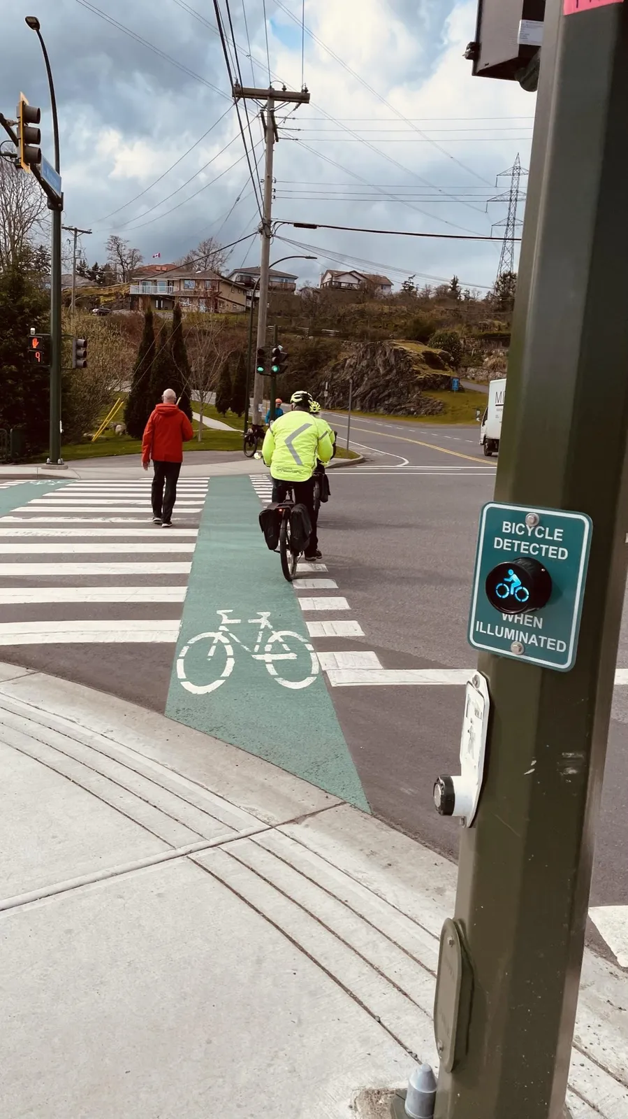
The Town of View Royal has an opportunity to make significant improvements to its active transportation network plan. Whether it begins to implement one of the 13 short-term priority infrastructure projects or adopt supporting programs / policies to encourage more active transportation—the Town now has a 10-year roadmap to make active transportation more viable, accessible, and safe for View Royal residents and visitors.
To capitalize on the ATNP and move toward quicker implementation of the short-term priority projects, the Town should continue to monitor and apply for provincial and federal funding. With 13 short-term infrastructure projects, the Town could obtain grants once it has a more detailed design for each one. For some of the larger projects that require coordination with different jurisdictions, View Royal must continue to work with its partners such as MOTI, BC Transit, and the CRD to provide safer and more convenient walking and cycling at trail crossings, transit stop locations, and on bridges, underpasses, and overpasses. This includes ensuring facilities meet current design standards in terms of width, clearance, and appropriate railings.
While it continues to advance these projects, the Town should also start to “pick at the low hanging fruit” and make changes to its current zoning bylaw and policies to help support more active transportation. Importantly, this 10-year plan must be a living document. The Town will need to revisit it periodically to ensure it is following the ATNP vision and objectives / targets. The Town should update the plan in 5 years (2028) to revisit the short-term priority project and continue to identify how it can improve active transportation options for the View Royal community.
Document Images
(1)