Council Meeting/Documents/B.C. LAND SURVEYOR’S SITE PLAN OF: LOT 15, SECTION 91, ESQUIMALT DISTRICT, PLAN 12112
Appendix
B.C. LAND SURVEYOR’S SITE PLAN OF: LOT 15, SECTION 91, ESQUIMALT DISTRICT, PLAN 12112
March 3, 2015Pages 138–1391 section
Detailed technical site plan showing proposed lot lines, building envelopes, staging areas, and setbacks for the 25 Stillwater Road subdivision.
October 31, 201425 Stillwater RoadLot 15, Plan 12112Proposed Lot A: 620 m2Proposed Lot B: 602 m2
B.C. LAND SURVEYOR’S SITE PLAN OF: LOT 15, SECTION 91, ESQUIMALT DISTRICT, PLAN 12112
FOR SUBDIVISION DISCUSSION PURPOSES
- MUNICIPALITY: Town of View Royal
- PID No.: 004-954-980
- ZONING: R1-B
- SITE AREA: 1227 m²
- SCALE: 1 : 150
- FILE: 11065 - 37
- DWG/DATE: 11065pt/ 2014-10-31
- Surveyor: Brad Cunnin Land Surveying, 4100 - 407 Swift Street, Victoria, BC V8W 1S2
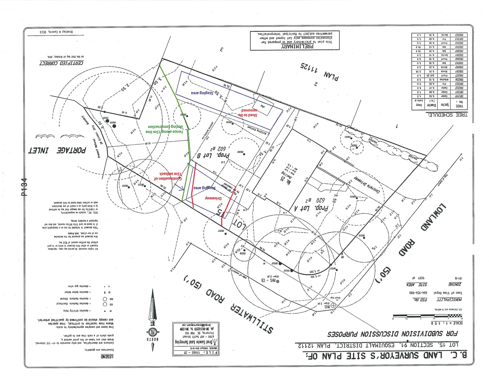
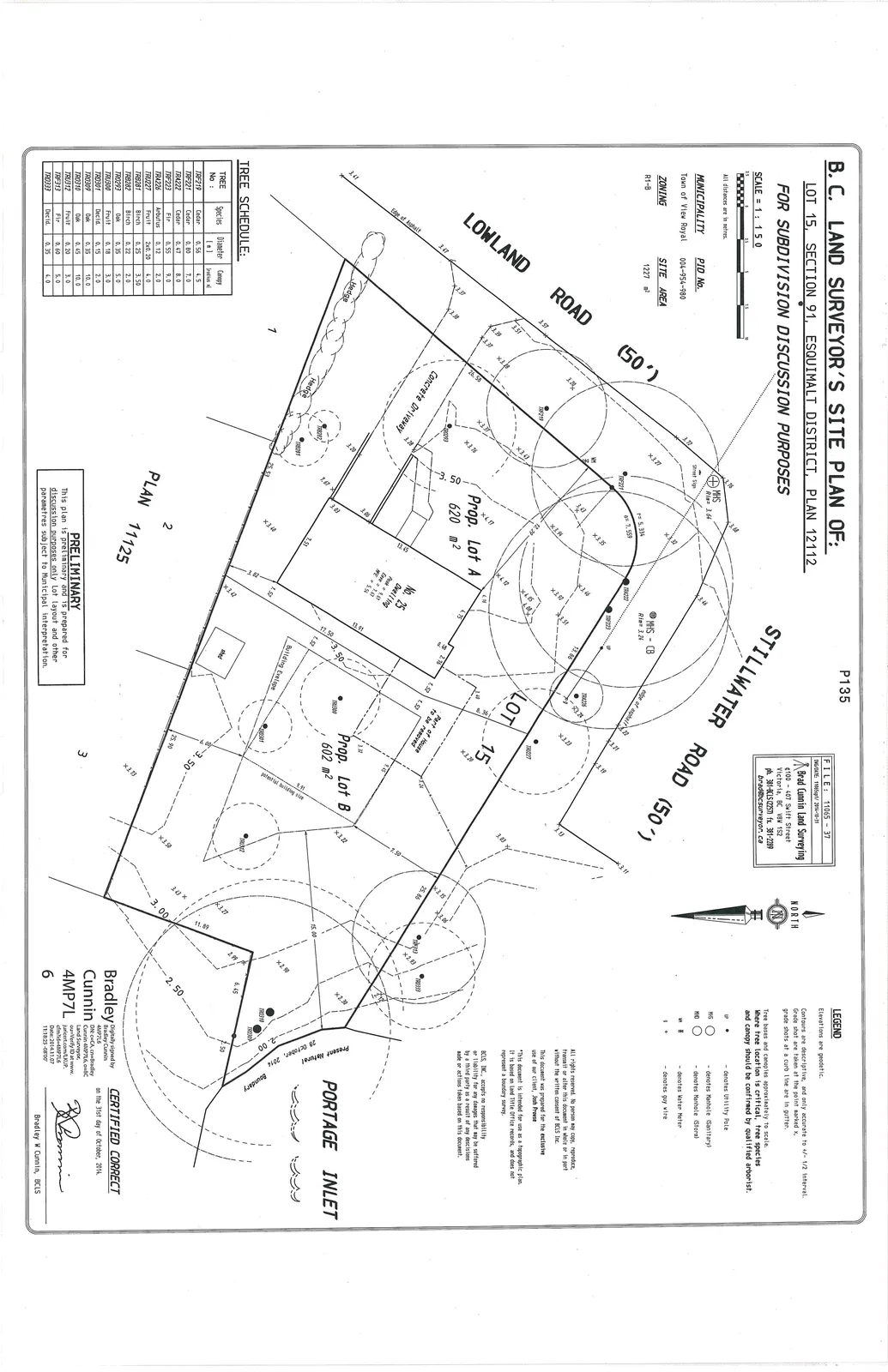
TREE SCHEDULE
| TREE No. | Species | Diameter (m) | Canopy (radius m) |
|---|---|---|---|
| TRF219 | Cedar | 0.56 | 4.5 |
| TRF221 | Cedar | 0.80 | 7.0 |
| TRF222 | Cedar | 0.47 | 8.0 |
| TRF223 | Fir | 0.55 | 9.0 |
| TRA226 | Arbutus | 0.12 | 2.0 |
| TRU227 | Fruit | 2x0.20 | 4.0 |
| TRB281 | Birch | 0.25 | 3.5 |
| TRB282 | Birch | 0.22 | 2.0 |
| TR0293 | Oak | 0.35 | 5.0 |
| TRU300 | Fruit | 0.18 | 3.0 |
| TRD301 | Decid. | 0.15 | 2.0 |
| TR0309 | Oak | 0.35 | 10.0 |
| TR0310 | Oak | 0.45 | 10.0 |
| TRU312 | Fruit | 0.20 | 3.0 |
| TRF313 | Fir | 0.60 | 5.0 |
| TRD333 | Decid. | 0.35 | 4.0 |
LEGEND
- Elevations are geodetic.
- Contours are descriptive, and only accurate to +/- 1/2 interval. Grade shot are taken at the point marked x, grade shots at a curb line are in gutter.
- Tree bases and canopies approximately to scale. Where tree location is critical, tree species and canopy should be confirmed by qualified arborist.
- UP: denotes Utility Pole
- MHS: denotes Manhole (Sanitary)
- MHO: denotes Manhole (Storm)
- WM: denotes Water Meter
- g: denotes guy wire
SITE PLAN NOTES AND DISCLAIMERS
- All rights reserved. No person may copy, reproduce, transmit or alter this document in whole or in part without the written consent of BCLS Inc.
- This document was prepared for the exclusive use of our client, Josh Prowse.
- This document is intended for use as a topographic plan. It is based on Land Title Office records, and does not represent a boundary survey.
- BCLS, INC. accepts no responsibility or liability for any damages that may be suffered by a third party as a result of any decisions made or actions taken based on this document.
- PRELIMINARY: This plan is preliminary and is prepared for discussion purposes only. Lot layout and other parameters subject to Municipal Interpretation.
SURVEYED SITE FEATURES
- Prop. Lot A: 620 m²
- Prop. Lot B: 602 m²
- No. 25 Dwelling:
- Peak = 8.61
- Eave = 7.15
- FFE = 5.54
- Structures to be Removed: Part of existing house, shed.
- Construction Details (from Image 1 annotations):
- Staging area (identified in two locations)
- Driveway
- Continuation of 7.5m setback
- Fence along 7.5m line during construction
- Adjacent Roads: Stillwater Road (50'), Lowland Road (50')
- Adjacent Waterway: Portage Inlet
Page 138–139
Extracted from: 2015 03 03 Council Agenda