Tree Inventory Report and Recommendations for the Proposed Development at 102 Atkins Road
Arborist report assessing the health and retention suitability of trees on the property to accommodate a proposed nine-home development.
Tree Inventory Report and Recommendations for the Proposed Development at 102 Atkins Road, View Royal, British Columbia.
Prepared by: Dr. Julian A. Dunster, R.P.F., R.P.P., ISA Certified Arborist ASCA Registered Consulting Arborist # 378 ISA Tree Risk Assessment Qualified BC Wildlife Danger Tree Assessor Honourary Life Member ISA + PNWISA
October 31, 2014
Background
The parcel of land at 1092 Atkins Road is being considered for rezoning and redevelopment. Dunster & Associates Environmental Consultants Ltd. have been asked to review tree conditions, and assist with design and layout of the new development. The goal of the project is to place nine new homes within the existing parcel in a manner that also ensures:
i) the development is not readily visible from the Galloping Goose trail and Atkins Road ii) development can take place without compromising the health and safety of the trees planned for retention.
The site has been visited several times by Julian Dunster. Numbered tags have been placed on trees and match the survey plans. The details below are current as of October 2104.
Existing Conditions and Inventory Details
Figure 1 shows an aerial view of the site and adjacent properties (digital information supplied by View Royal).
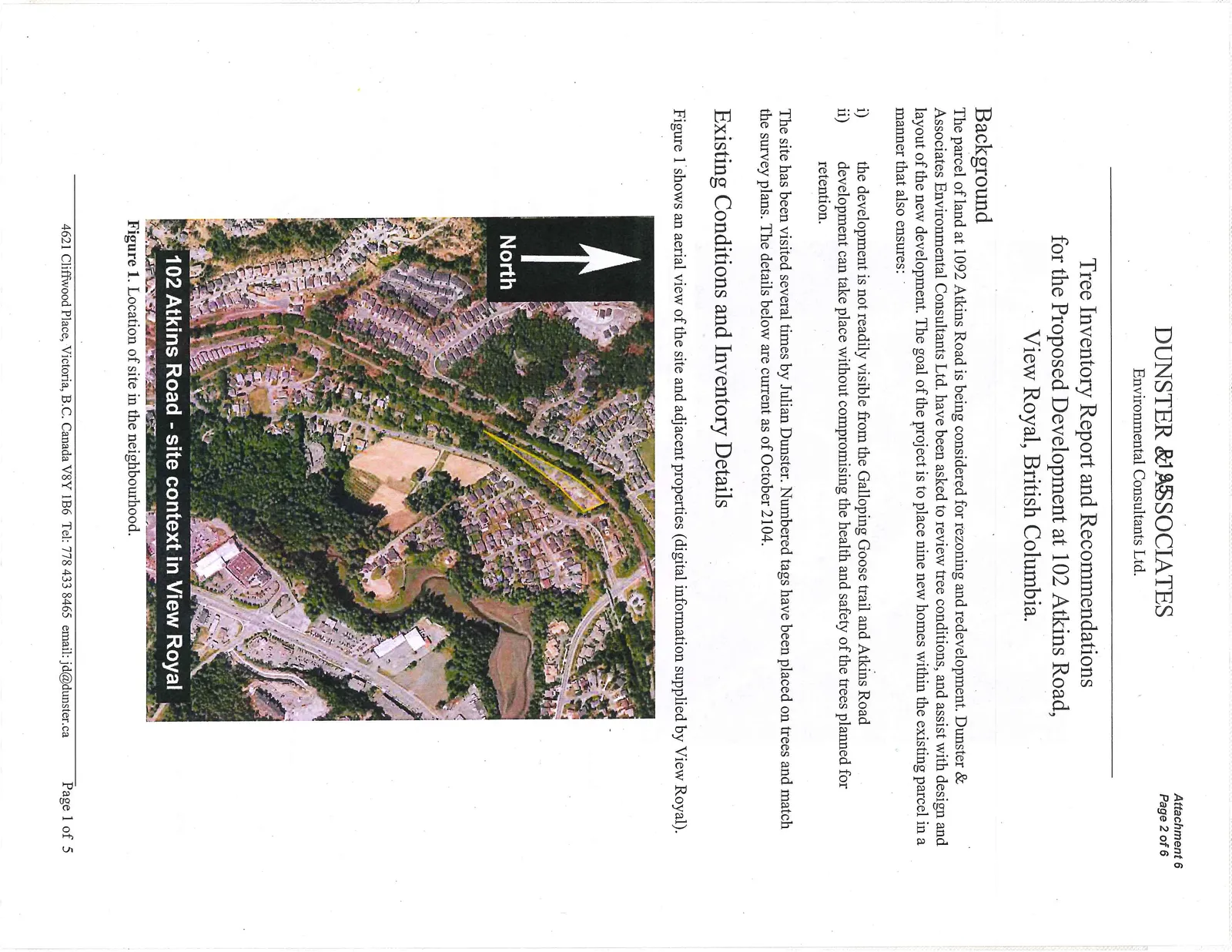
Figure 2 is a close up view of the site.
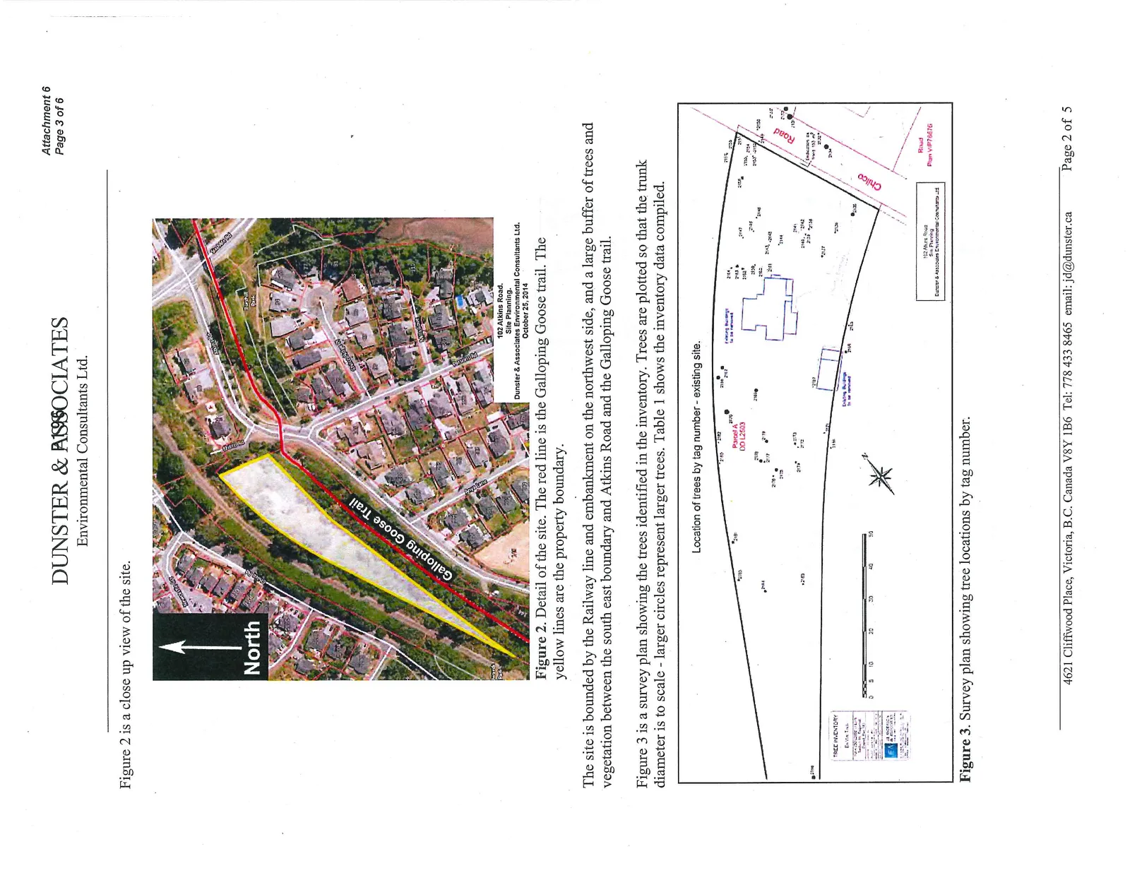
The site is bounded by the Railway line and embankment on the northwest side, and a large buffer of trees and vegetation between the south east boundary and Atkins Road and the Galloping Goose trail.
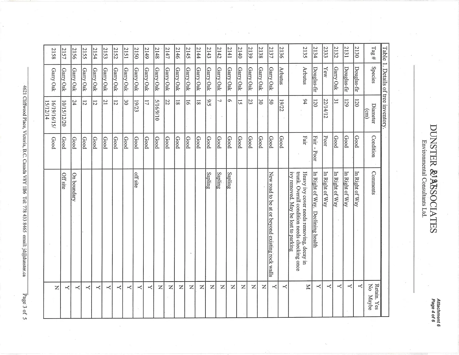
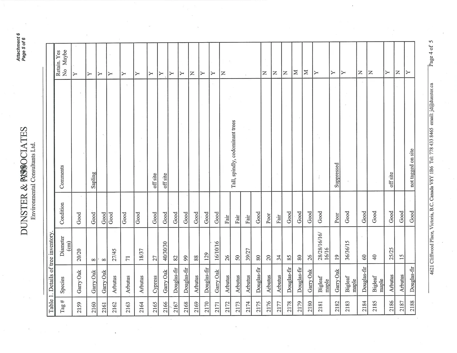
Figure 3 is a survey plan showing the trees identified in the inventory. Trees are plotted so that the trunk diameter is to scale - larger circles represent larger trees. Table 1 shows the inventory data compiled.
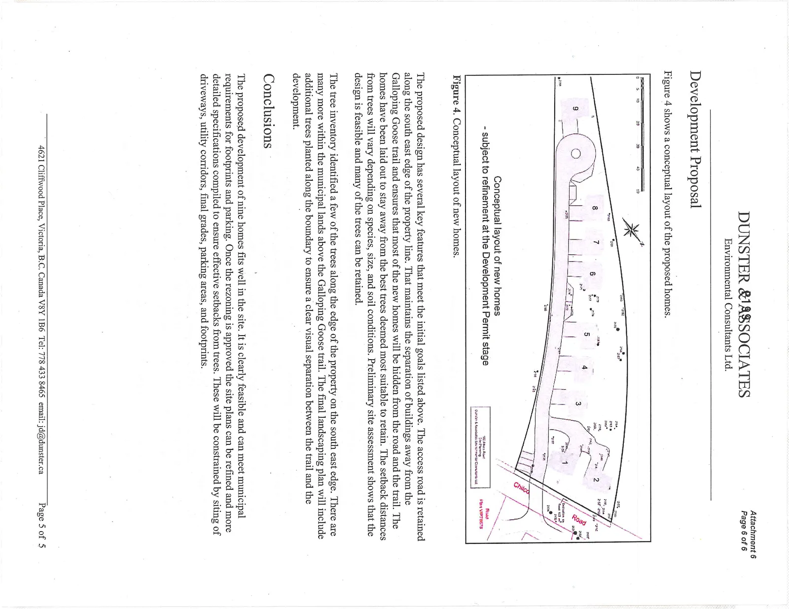
Table 1. Details of tree inventory.
| Tag # | Species | Diameter (cm) | Condition | Comments | Retain (Yes/No/Maybe) |
|---|---|---|---|---|---|
| 2130 | Douglas-fir | 120 | Good | In Right of Way | Y |
| 2131 | Douglas-fir | 129 | Good | In Right of Way | Y |
| 2132 | Garry Oak | 31 | Good | In Right of Way | Y |
| 2333 | Yew | 22/14/12 | Poor | In Right of Way | Y |
| 2134 | Douglas-fir | 120 | Fair - Poor | In Right of Way. Declining health | Y |
| 2135 | Arbutus | 94 | Fair | Heavy ivy cover needs removing, decay in trunk. Overall condition needs checking once ivy removed. May be lost to parking | M |
| 2136 | Arbutus | 19/22 | Good | Y | |
| 2137 | Garry Oak | 50 | Good | New road to be at or beyond existing rock walls | Y |
| 2138 | Garry Oak | 30 | Good | N | |
| 2139 | Garry Oak | 23 | Good | N | |
| 2140 | Garry Oak | 15 | Good | N | |
| 2141 | Garry Oak | 6 | Good | Sapling | N |
| 2142 | Garry Oak | 7 | Good | Sapling | N |
| 2143 | Garry Oak | 9/5 | Good | Sapling | N |
| 2144 | Garry Oak | 18 | Good | N | |
| 2145 | Garry Oak | 16 | Good | N | |
| 2146 | Garry Oak | 18 | Good | N | |
| 2147 | Garry Oak | 22 | Good | N | |
| 2148 | Garry Oak | 5/16/9/10 | Good | N | |
| 2149 | Garry Oak | 17 | Good | Y | |
| 2150 | Garry Oak | 19/23 | Good | off site | Y |
| 2151 | Garry Oak | 30 | Good | Y | |
| 2152 | Garry Oak | 12 | Good | Y | |
| 2153 | Garry Oak | 21 | Good | Y | |
| 2154 | Garry Oak | 12 | Good | Y | |
| 2155 | Garry Oak | 12 | Good | Y | |
| 2156 | Garry Oak | 24 | Good | On boundary | Y |
| 2157 | Garry Oak | 10/15/12/20 | Good | Off site | Y |
| 2158 | Garry Oak | 16/19/16/15/ 15/12/14 | Good | N | |
| 2159 | Garry Oak | 20/20 | Good | Y | |
| 2160 | Garry Oak | 8 | Good | Sapling | Y |
| 2161 | Garry Oak | 8 | Good | Y | |
| 2162 | Arbutus | 27/45 | Good | Y | |
| 2163 | Arbutus | 71 | Good | Y | |
| 2164 | Arbutus | 18/37 | Good | Y | |
| 2165 | Cypress | 27 | Good | off site | Y |
| 2166 | Garry Oak | 40/30/30 | Good | off site | Y |
| 2167 | Douglas-fir | 82 | Good | Y | |
| 2168 | Douglas-fir | 99 | Good | Y | |
| 2169 | Arbutus | 88 | Good | N | |
| 2170 | Douglas-fir | 129 | Good | Y | |
| 2171 | Garry Oak | 16/10/16 | Good | Y | |
| 2172 | Arbutus | 26 | Fair | N | |
| 2173 | Arbutus | 50 | Fair | Tall, spindly, codominant trees | |
| 2174 | Arbutus | 39/27 | Fair | ||
| 2175 | Douglas-fir | 80 | Good | ||
| 2176 | Arbutus | 20 | Poor | N | |
| 2177 | Arbutus | 34 | Fair | N | |
| 2178 | Douglas-fir | 85 | Good | N | |
| 2179 | Douglas-fir | 80 | Good | M | |
| 2180 | Garry Oak | 26 | Good | M | |
| 2181 | Bigleaf maple | 28/28/16/16/ 16/16 | Good | Y | |
| 2182 | Garry Oak | 19 | Poor | Suppressed | Y |
| 2183 | Bigleaf maple | 36/36/15 | Good | Y | |
| 2184 | Douglas-fir | 60 | Good | N | |
| 2185 | Bigleaf maple | 40 | Good | N | |
| 2186 | Arbutus | 25/25 | Good | off site | Y |
| 2187 | Arbutus | 15 | Good | N | |
| 2188 | Douglas-fir | Good | not tagged on site | Y |
Development Proposal
Figure 4 shows a conceptual layout of the proposed homes.
The proposed design has several key features that meet the initial goals listed above. The access road is retained along the south east edge of the property line. That maintains the separation of buildings away from the Galloping Goose trail and ensures that most of the new homes will be hidden from the road and the trail. The homes have been laid out to stay away from the best trees deemed most suitable to retain. The setback distances from trees will vary depending on species, size, and soil conditions. Preliminary site assessment shows that the design is feasible and many of the trees can be retained.
The tree inventory identified a few of the trees along the edge of the property on the south east edge. There are many more within the municipal lands above the Galloping Goose trail. The final landscaping plan will include additional trees planted along the boundary to ensure a clear visual separation between the trail and the development.
Conclusions
The proposed development of nine homes fits well in the site. It is clearly feasible and can meet municipal requirements for footprints and parking. Once the rezoning is approved the site plans can be refined and more detailed specifications compiled to ensure effective setbacks from trees. These will be constrained by siting of driveways, utility corridors, final grades, parking areas, and footprints.
Document Images
(3)