TOWN OF VIEW ROYAL COUNCIL REPORT - DEVELOPMENT VARIANCE PERMIT 2015/03 – 130 Burnett Road
Staff report recommending the decline of a variance request to increase fence height along the side property line adjacent to the E&N Rail Trail.
TOWN OF VIEW ROYAL COUNCIL REPORT
TO: Mayor and Council DATE: April 1, 2015 FROM: Jeff Chow, MCIP RPP, Senior Planner MEETING DATE: April 7, 2015 FILE NO.: 3090-20-2015/03
DEVELOPMENT VARIANCE PERMIT 2015/03 – 130 Burnett Road
RECOMMENDATION
THAT Development Variance Permit 2015/03 be declined.
CHIEF ADMINISTRATIVE OFFICER'S COMMENTS
I concur with the recommendation.
DIRECTOR OF DEVELOPMENT SERVICES' COMMENTS
I concur with the recommendation.
PURPOSE OF REPORT
To present an application for a Development Variance Permit to permit a maximum fence height of 2.5m along the side property line where 2.0m is the maximum permitted.
BACKGROUND
The 700m² subject property is a single family residential lot located on Burnett Road directly adjacent to the E&N rail right-of-way (see Attachment 1). Construction of Phase 2 of the E&N Rail Trail between Four Mile Bridge and the Island Highway / Burnside Road West intersection began in the summer of 2014. The trail is being built by the Capital Regional District within the E&N rail right-of-way between the railway tracks and the side lot line of the subject property.
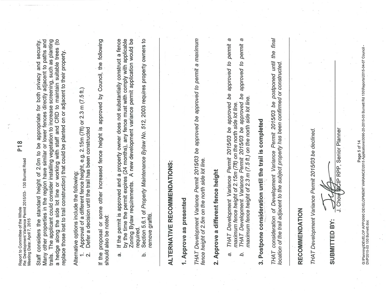
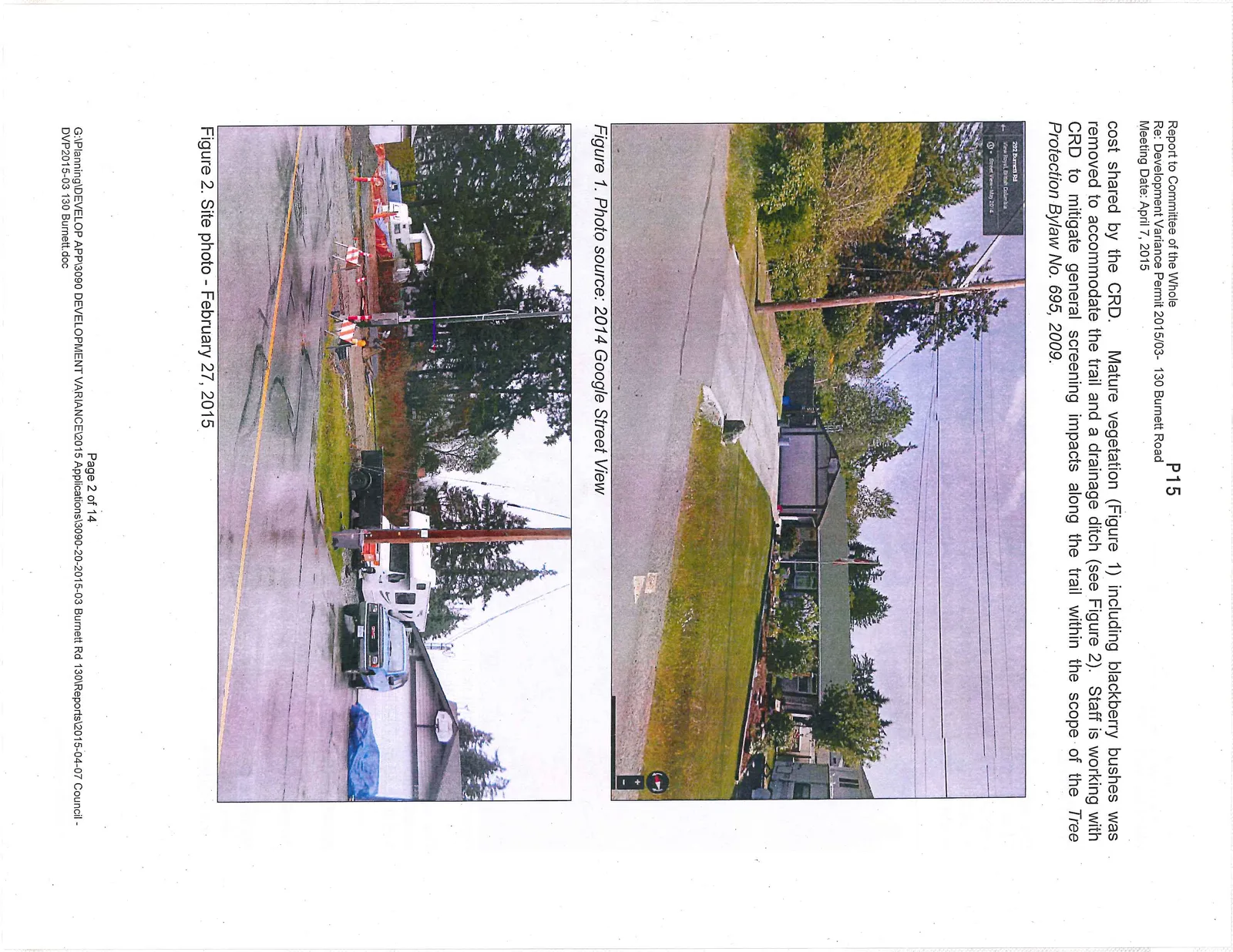
The CRD has advised that generally the trail construction has already been designed to maximize distance from adjoining properties, so replacement fences would not be provided or cost shared by the CRD. Mature vegetation (Figure 1) including blackberry bushes was removed to accommodate the trail and a drainage ditch (see Figure 2). Staff is working with CRD to mitigate general screening impacts along the trail within the scope of the Tree Protection Bylaw No. 695, 2009.
PROPOSAL
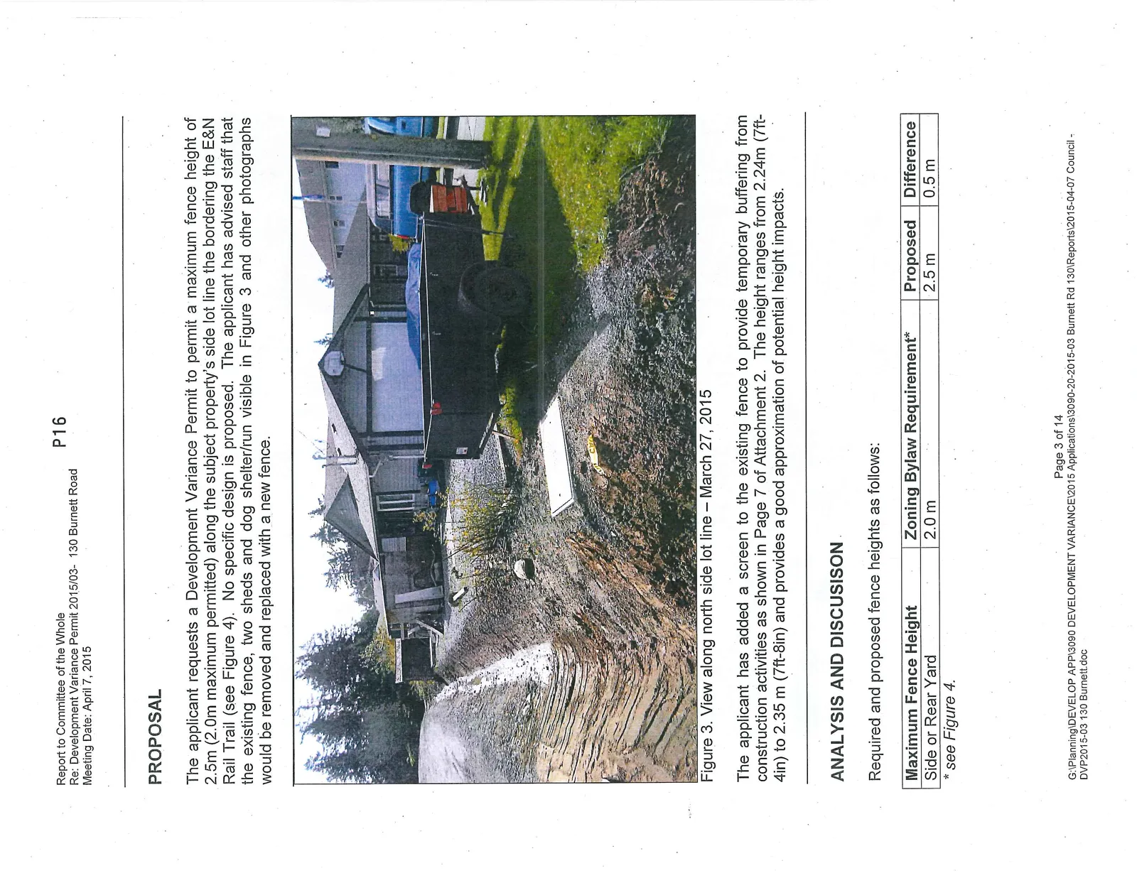
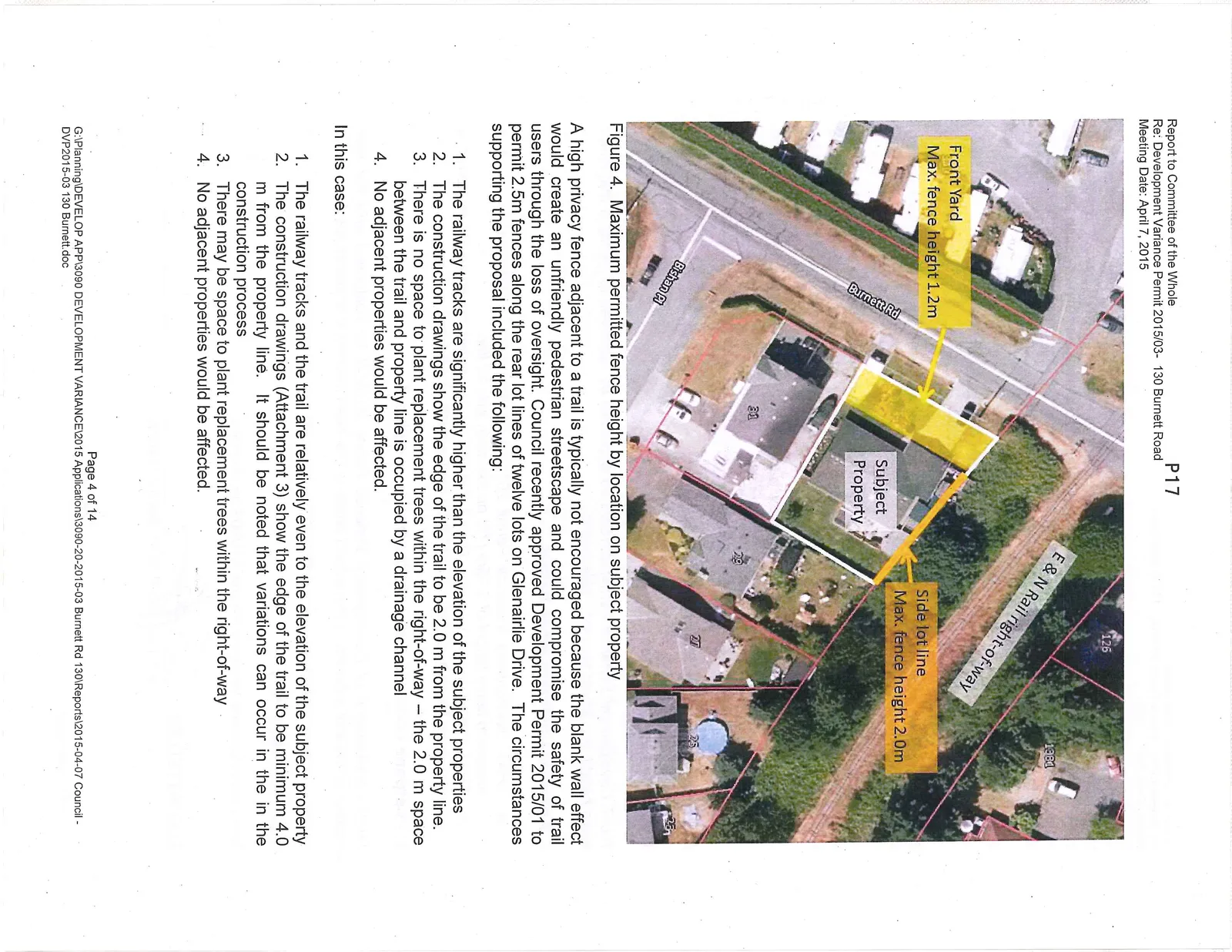
The applicant requests a Development Variance Permit to permit a maximum fence height of 2.5m (2.0m maximum permitted) along the subject property’s side lot line the bordering the E&N Rail Trail (see Figure 4). No specific design is proposed. The applicant has advised staff that the existing fence, two sheds and dog shelter/run visible in Figure 3 and other photographs would be removed and replaced with a new fence.
The applicant has added a screen to the existing fence to provide temporary buffering from construction activities as shown in Page 7 of Attachment 2. The height ranges from 2.24m (7ft-4in) to 2.35 m (7ft-8in) and provides a good approximation of potential height impacts.
ANALYSIS AND DISCUSSION
Required and proposed fence heights as follows:
| Maximum Fence Height | Zoning Bylaw Requirement* | Proposed | Difference |
|---|---|---|---|
| Side or Rear Yard | 2.0 m | 2.5 m | 0.5 m |
* see Figure 4.
A high privacy fence adjacent to a trail is typically not encouraged because the blank wall effect would create an unfriendly pedestrian streetscape and could compromise the safety of trail users through the loss of oversight. Council recently approved Development Permit 2015/01 to permit 2.5m fences along the rear lot lines of twelve lots on Glenairlie Drive. The circumstances supporting the proposal included the following:
- The railway tracks are significantly higher than the elevation of the subject properties
- The construction drawings show the edge of the trail to be 2.0 m from the property line.
- There is no space to plant replacement trees within the right-of-way – the 2.0 m space between the trail and property line is occupied by a drainage channel
- No adjacent properties would be affected.
In this case:
- The railway tracks and the trail are relatively even to the elevation of the subject property
- The construction drawings (Attachment 3) show the edge of the trail to be minimum 4.0 m from the property line. It should be noted that variations can occur in the in the construction process
- There may be space to plant replacement trees within the right-of-way
- No adjacent properties would be affected.
Staff considers the standard height of 2.0m to be appropriate for both privacy and security. Many other properties in the region have similar or lower fences directly adjacent to paths and trails. The applicant could consider installing vegetation to increase screening, such as planting a hedge along the side lot line or working with staff and CRD to maintain suitable trees (to replace those lost to trail construction) that could be planted on or adjacent to their property.
Alternative options include the following:
- Approval of a different fence height, e.g. 2.15m (7ft) or 2.3 m (7.5 ft.)
- Defer a decision until the trail has been constructed
If the proposal or some other increased fence height is approved by Council, the following should also be noted:
a. If the permit is approved and a property owner does not substantially construct a fence by the time the permit expires (24 months), any fence must comply with applicable Zoning Bylaw requirements. A new development variance permit application would be required. b. Section 5.6.1 of Property Maintenance Bylaw No. 512, 2003 requires property owners to remove graffiti.
ALTERNATIVE RECOMMENDATIONS:
1. Approve as presented THAT Development Variance Permit 2015/03 be approved to permit a maximum fence height of 2.5m on the north side lot line.
2. Approve a different fence height a. THAT Development Variance Permit 2015/03 be approved to permit a maximum fence height of 2.15m (7ft) on the north side lot line. b. THAT Development Variance Permit 2015/03 be approved to permit a maximum fence height of 2.3 m (7.5 ft.) on the north side lot line.
3. Postpone consideration until the trail is completed THAT consideration of Development Variance Permit 2015/03 be postponed until the final location of the trail adjacent to the subject property has been confirmed or constructed.
RECOMMENDATION
THAT Development Variance Permit 2015/03 be declined.
SUBMITTED BY: J. Chow MCIP RPP, Senior Planner
Document Images
(2)