COUNCIL REPORT: DEVELOPMENT PERMIT 2015/09 AND COVENANT AMENDMENT - 2429 Chilco Road
Staff report recommending the enclosure of a drainage channel and the removal of wildfire protection covenants on certain lots.
TOWN OF VIEW ROYAL
Council Report
| TO: | Mayor & Council | DATE: | July 16, 2015 |
| FROM: | J. Chow, Senior Planner | MEETING DATE: | July 21, 2015 |
| FILE NO.: | 3060-20-2015/09 |
DEVELOPMENT PERMIT 2015/09 AND REQUEST TO AMEND A COVENANT ON 2429 Chilco Road (Thetis Vale Phase 6)
RECOMMENDATIONS:
That the July 16, 2015 report from the Senior Planner titled “Development Permit Application 2015/09 and Request to Amend a Covenant on 2429 Chilco Road (Thetis Vale Phase 6)” be received.
CHIEF ADMINISTRATIVE OFFICER’S COMMENTS:
I concur with the recommendation.
DIRECTOR OF DEVELOPMENT SERVICES’ COMMENTS:
I concur with the recommendation.
DIRECTOR OF PROTECTIVE SERVICES’ COMMENTS:
I concur with the recommendation.
PURPOSE OF REPORT:
The purpose of this report is to introduce the following:
- A development permit application to allow enclosure of a drainage channel.
- A request to remove covenant requirements for wildfire protection for ten lots.
BACKGROUND:
The 3.06 hectare subject property is located north of Chilco Road and south of Trans-Canada Highway. It is known as Phase 6 of the Thetis Vale development. Land use to the south on Cahilty Lane and Thetis Vale Crescent is detached single family housing. The abutting parcel to the west is currently forested but has been rezoned for single family residential subdivision as Thetis Vale Phase 7. The portion of Chilco Road west of this property is closed to vehicular traffic.
In April 2011, the parcel was rezoned from Rural: A-1 to Comprehensive Development – 19 (Mixed Residential): CD-19. Subzones apply to various parts of the parcel that permit the development of a mixed residential development including 19 single family lots and two multifamily lots that would have a total of 22 units of strata duplex housing.
1. Development Permit history
The parcel is within two development permit areas: the Mixed Residential Development Permit Area for the regulation of form and character of multifamily development and the Terrestrial Sensitive Ecosystems Development Permit Area for the protection of the natural environment. Development Permits 2014/10 and 2014/12 were approved this year for the form and character of development on the two multifamily lots and to require fire-resistant construction. Development Permit 2010/15 was approved to allow subdivision and protect the natural environment. The concept plan included preservation of a drainage channel through the site as shown in Attachment 3.
2. Covenant FB408215
In April 2011, the parcel was rezoned from Rural: A-1 to CD-19: Comprehensive Development (Mixed Residential) A covenant was registered at that time to secure amenities including park dedication, trail construction, sidewalk construction, and a $50,000 contribution towards the Chilco Trails project. The covenant also includes requirements to register a covenant on Proposed Lots 1-10 on the western edge of the site with regard to Town’s FireSmart Guidelines and Urban Wildfire Plan. Measures include:
- 10 m fuel modification zones around structures on certain lots (i.e. kept clear of flammable vegetation and other materials)
- Pruning, trimming or removal of trees and bushes for fire protection
- Planting of native fire resistant species
- Installation of sprinkler systems in houses as necessary
- Management Plan for fire safety during land clearing and construction
PROPOSAL:
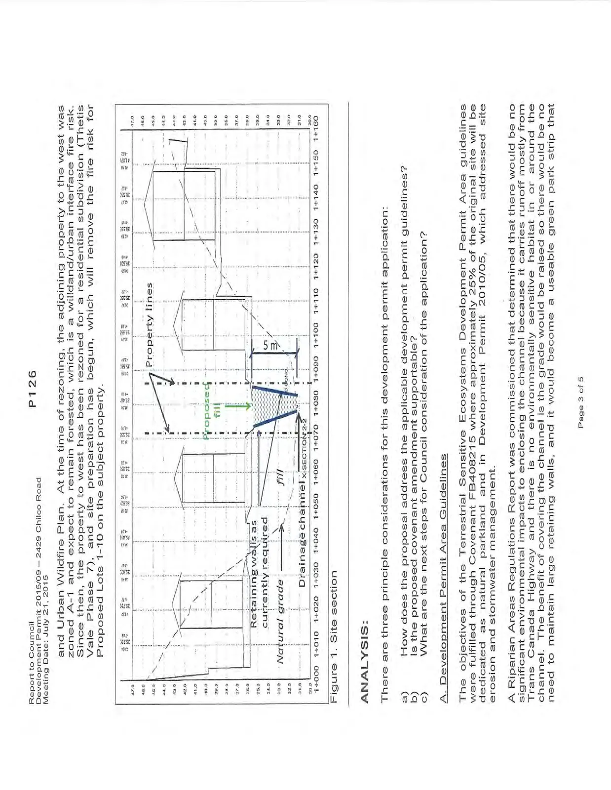
An amendment to Development Permit 2010/15 is proposed to enclose a drainage channel as shown in Figure 1 and Attachment 4. In preparing detailed servicing plans for subdivision it was determined that there would be issues for maintenance of the drainage channel in terms of access and operational costs for the Town.
Substantial amounts of fill are needed on the lots adjacent to the drainage channel so that houses would accessible to the road. As consequence retaining walls up to five metres would be needed on either side of the drainage channel as shown in Figure 1. It was found that access to maintain the drainage would be problematic for the Town.
An amendment to Covenant FB408215 is requested to remove the requirement to register a covenant on Proposed Lots 1-10 with regard to Town’s FireSmart Guidelines and Urban Wildfire Plan. At the time of rezoning, the adjoining property to the west was zoned A-1 and expect to remain forested, which is a wildland/urban interface fire risk. Since then, the property to west has been rezoned for a residential subdivision (Thetis Vale Phase 7), and site preparation has begun, which will remove the fire risk for Proposed Lots 1-10 on the subject property.
ANALYSIS:
There are three principle considerations for this development permit application:
a) How does the proposal address the applicable development permit guidelines? b) Is the proposed covenant amendment supportable? c) What are the next steps for Council consideration of the application?
A. Development Permit Area Guidelines
The objectives of the Terrestrial Sensitive Ecosystems Development Permit Area guidelines were fulfilled through Covenant FB408215 where approximately 25% of the original site will be dedicated as natural parkland and in Development Permit 2010/05, which addressed site erosion and stormwater management.
A Riparian Areas Regulations Report was commissioned that determined that there would be no significant environmental impacts to enclosing the channel because it carries runoff mostly from Trans Canada Highway and there is no environmentally sensitive habitat in or around the channel. The benefit of covering the channel is the grade would be raised so there would be no need to maintain large retaining walls, and it would become a useable green park strip that would provide another pedestrian route through the site. It would save the Town from the greater expense that would otherwise be required to maintain the challenging slopes around the channel.
The channel does drain into fish bearing water, so work can only be done during summer months. Given the staff acknowledgement of the benefits of covering the channel, the applicant has taken the initiative to enclose the drain during the fisheries window with supervision from a registered professional biologist.
B. Covenant amendment
The proposed covenant amendment can be supported because the wildland/urban interface fire hazard will no longer exist for Proposed Lots 1 to 10.
C. Next steps
Council may consider the application at an upcoming meeting following notification of residents and owners of nearby properties as required by the Local Government Act and Development Procedures Bylaw No. 730, 2009, and pending the receipt of any additional relevant information that may be requested by Council arising from this report. In the case of the covenant amendment, it was enacted as part of rezoning which required a 400m notification radius. A Council meeting to make a decision on the covenant amendment therefore requires a 400m notification radius.
RECOMMENDATION:
That the July 16, 2015 report from the Senior Planner titled “Development Permit Application 2015/09 and Request to Amend a Covenant on 2429 Chilco Road (Thetis Vale Phase 6)” be received.
SUBMITTED BY: Jeff Chow, MCIP, RPP, Senior Planner
REVIEWED BY: Lindsay Chase, MCIP, RPP, Director of Development Services
ATTACHMENTS:
- Subject Property Map
- Letter to Mayor and Council from MH Johnston & Associates – June 22, 2015
- Grading Plan 2450-00-C.107 – Associated Engineering, May 6, 2015
- Typical Cross Sections 2450-00-XS101 – Associated Engineering, May 6, 2015
Document Images
(3)