Strathcona Forestry Consulting: Interface Fire Hazard Assessment – 2601 Herbate Road
Professional forester's report on wildfire risk and required FireSmart mitigation measures.
Margaret Symon, RPF PCP Strathcona Forestry Consulting PO Box 457 Shawnigan Lake, BC V0R 2Wo
To: Jeff Chow, Development Services Town of View Royal buildingpermits@viewroyal.ca
cc: James Trueit 2601 Herbate Road
25/05/2015
Re: Interface Fire Hazard Assessment at Building Permit – 2601 Herbate Road
Background: In accordance with the Town of View Royal Development Permit Area guidelines for wildfire, James Trueit retained Strathcona Forestry Consulting to conduct an interface wildfire threat assessment of 2601 Herbate Road prior to building permit. Mr. Trueit is planning to construct a new single-family home on the property.
The interface (wildland urban interface/wildland residential interface), describes any area where combustible wildland fuels are found adjacent to homes or other buildings. Fuel may occur at the interface, where development and wildland vegetation meet at a well-defined boundary, or in the intermix, where development and wildland fuels intermingle with no clearly defined boundary (as at the subject area, which is located within Thetis Lake Regional Park).
Hazard Assessment: This report describes the vegetation, terrain, and local infrastructure at the subject property, and provides recommendations that will assist the property owner to reduce the risk of wildfire. Assessment criteria are based on Rating Wildfire Threats in British Columbia (https://ground.hpr.for.gov.bc.ca/ratingthreats.htm), FireSmart (FireSmart, Protecting Your Community From Wildfire (Second Edition. Partners in Protection Partners in Protection, 2003 www.partnersinprotection.ab/ca), and the Home Owners FireSmart Manual (BC Edition). Fire behavior modeling is standardized with the Canadian Forest Fire Danger Rating System (CFFDRS). FireSmart Fuel Zones are described in Appendix 1. Fuel Types listed in this assessment are customized from the CFFDRS Fuel Type list for applicability in south coastal BC (see Appendix 2). This assessment conforms to fire hazard planning authorized by Section 3(2) of the BC Fire Services Act.
Field Inspection: Strathcona Forestry Consulting conducted the wildfire hazard assessment on May 13, 2015. Mr. Trueit provided a site tour of the property. Weather was sunny and warm.
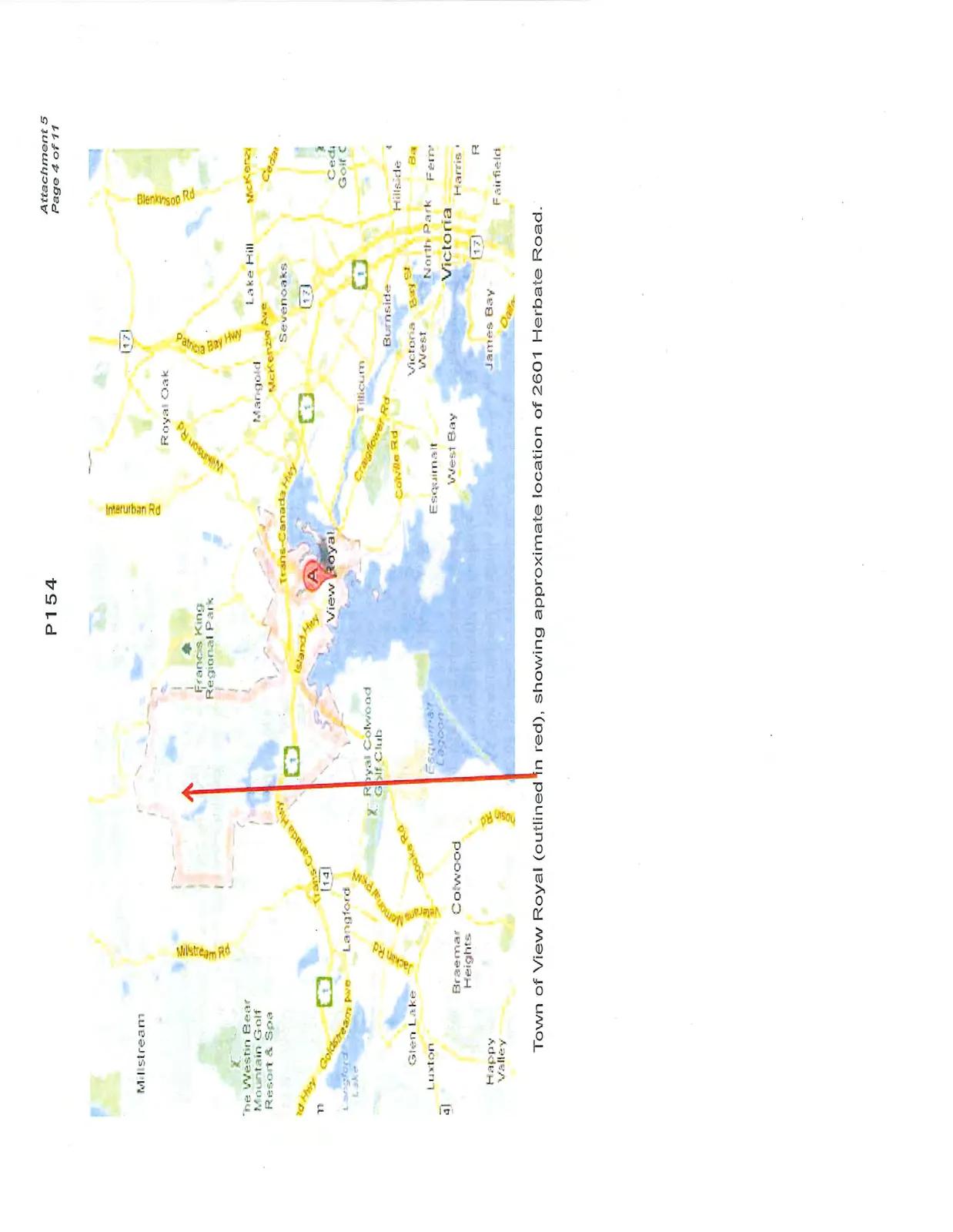
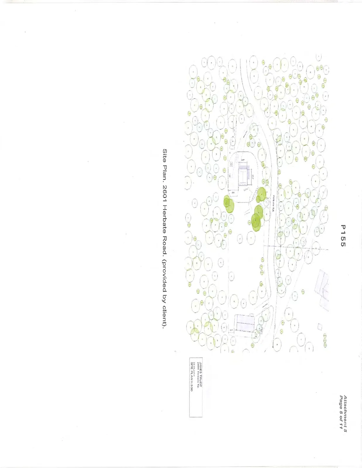
Location and Description of Subject Property: The subject property at 2601 Herbate Road is located in a small rural neighbourhood at the north end of Thetis Lake Regional Park (map pg. 4; site plan pg. 5). The property is accessed the TransCanada Highway via Watkiss Way, Highland Road, and Barker Road. The subject property is 1.2 acres.
The subject property is located in low hilly terrain. Aspect is variable.
The subject property and surrounding area are classified in the Coastal Douglas-fir moist maritime (CDFmm) biogeoclimatic subzone, which represents the mildest climate in Canada. Common soils are well-drained Brunisols. Vegetation cover consists of open second growth coniferous cover (with minor arbutus component) classified as Fuel Type C-5 (moderately well-stocked coniferous stands; tree crowns separated from ground; more or less continuous needle litter). The proposed building envelope is in a partially cleared area (mossy rock outcropping: modified Fuel Type C-2). Extensive stands of mature second-growth coniferous forest in Thetis Lake Park surround the subject property.
Prevailing winds are southeasterly/southwesterly. Under warm dry conditions, a fire start at the subject property or adjacent lands would spread rapidly to the surrounding forest stands at Thetis Lake Regional Park. Conversely, a fire start at Thetis Lake Park has potential to spread to homes at the north end of the park.
Fire Suppression. View Royal Fire/Rescue is a composite fire department that operates from 280 Island Highway. According to View Royal Fire/Rescue, response time to the subject property is "over 10 minutes" (phone conversation with VRF/R Duty Officer. May 20, 2015). Fire department response time is the elapsed time, in minutes, from when the first fire fighting unit is dispatched to when the first fire fighting unit arrives at the emergency scene. Fire department intervention time is crucial in determining the consequences of a fire in terms of deaths, injuries, and loss of property and damage to the environment. An early aggressive and offensive primary interior attack on a working fire is usually the most effective strategy to reduce the loss of lives and property damage.
Mutual Aid. Fire Departments within CRD fire protection areas operate under a mutual aid agreement with other fire departments within (and outside) the region. In the case of a serious fire, mutual aid from adjoining fire departments (i.e., Colwood) benefits fire suppression by pooling manpower and resources (water supply, water tenders, etc.).
Wildfires. CRD Fire Departments automatically respond to structure fires and small easily accessible bush fires. Assistance from the Wildfire Management Branch is requested when larger brush fires and/or forest fires occur in the area.
Water Supply. An adequate and reliable water supply for firefighting is an essential part of a community's fire protection system. The BC Building Code states all structures (proposed and existing) within interface areas should have a water supply for firefighting purposes that meets requirements of either the FUS (Fire Underwriters Survey) or the National Fire Protection Association (NFPA).
The subject property will not be serviced by community piped water; there are no hydrants in the area.
In fire protection areas served by a community water system, water supply for fire protection generally consists of a piped system in common with domestic potable water. Where no adequate or reliable water distribution system exists (as at the subject area), minimum specifications for fireflow may be based on NFPA standards.
In areas not served by community water systems, the Wildfire Management Branch generally recommends a minimum of 2500 gallons for on-site emergency fireflow. In this situation, the applicant is planning to install a gravity fed 2500 gallon tank. There is already a 500 gallon tank on site.
Access. FireSmart infrastructure and access increase the resident and firefighter safety, and facilitate quick response by firefighters. All developments should have sufficient access for emergency vehicles, including 2-way road access in and out of any site, and safe driveway access. Local government standards for roads and driveways generally follow the Geometric Design Guide for Canadian Roads (www.tac-atc). Mr. Trueit is planning to develop a short, gently sloping gravel driveway at the east end of the subject property. There is a wide turnaround at the end of Herbate Road.
Wildland Urban Interface Wildfire Threat Assessment Results: Scoring from the WUI Wildfire Threat Worksheet (from Rating Wildfire Threats in British Columbia) rates the subject property with a High Wildfire Threat. Under the MFLNRO Wildfire Threat Rating system, ratings of High and Extreme are unacceptable. Ratings must be low or moderate for an area to be considered safe. The rating reflects biophysical and development characteristics of the general area (hilly topography, intermix >1 structure/ha, continuous forest fuels in the general area, no current water supply at new lot).
This report contains recommendations to reduce the fire threat rating to acceptable levels.
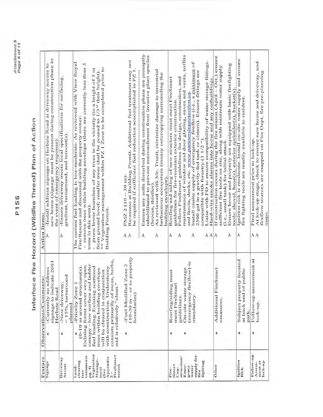
Hazard Assessment Checklist: FireSmart comments and recommendations for action are outlined in the checklist on pg. 6. Photos are shown in Appendix 3.
Interface Fire Hazard (Wildfire Threat) Plan of Action
| Feature | Observations/Comments | Action Items |
|---|---|---|
| Signage | Currently no address signage to indicate 2601 Herbate Road | Install address signage on Herbate Road at driveway access to new home (signage must be present during construction phase in the event of emergency response). |
| Driveway Access | New driveway, < 15%, turnaround planned | Ensure driveway meets local specifications for surfacing, gradient, turnaround, and turnout(s). |
| Land-clearing (see comments pg. 4) Vegetation Management (See Appendix 2 - FireSmart zones) | Priority Zone 1 (0-10 m around structure(s). Existing forest cover very open canopy - low surface and ladder fuel loading. Existing scattered trees within building envelope will be cleared in conjunction with construction. Understorey consists primarily of moss, herbs, and is relatively "clean." | The current fuel loading is low-moderate. As reviewed with View Royal Fire/Rescue and discussed with the property owner: - remove trees within building envelope (there are currently less than 5 trees in this area). - prune lower branches of any trees in the vicinity (to a height of 3 m from ground level; smaller trees shall be pruned to 1/3rd their height). **Vegetation management within PZ 1 Zone to be completed prior to Building Permit. |
| Fuel Modified Zone 2 (10-30 m - or to property boundaries) | FMZ 2 (10 - 30 m): Re-assess at Building Permit. Additional fuel treatment may not be required if sufficient fuel reduction accomplished in PZ 1. |
|
| Ensure any soils disturbed during construction phase are promptly rehabilitated to prevent encroachment from invasive plant species (broom, thistles). As reviewed with Mr. Trueit, minimize damage to terrestrial herbaceous ecosystem (mossy outcropping surrounding the building envelope). |
||
| FireSmart Construction/Emergency water supply for fire fighting | Roofing/siding must meet FireSmart guidelines. On-site water storage (emergency fireflow) is mandatory. |
Roofing and siding of new structure must meet FireSmart guidelines for fire-resistant exterior construction. Follow FireSmart guidelines for design, construction, and maintenance of window and door glazing, eaves and vents, soffits and fascia, decks, etc. www.partnersinprotection.ca Install onsite supply of emergency fireflow (i.e., a minimum of 2500 gal in a gravity-fed tank or cistern). Ensure fittings are compatible with forestry (1 1/2 "). Liaise with FD to ensure compatibility of water storage fittings. Hard-wire smoke alarms into home and any outbuildings. |
| Other | Additional FireSmart measures. | If construction occurs during the fire season (April - Oct.) ensure sufficient fire tools on site, along with minimum water supply (i.e., small tank) for initial attack. Ensure home and property are equipped with basic firefighting tools: shovel, hose(s), exterior sprinkler(s), bucket(s). |
| Ignition Risk | Subject property located at back end of public park. | Ignition risk is moderate. Install on-site water supply and ensure fire fighting tools are readily available to resident. |
| Follow-up Assessment at lock-up | Follow-up assessment at lock-up. | Final assessment prior to lock-up. At lock-up stage, check to ensure new home and driveway, and fireflow sources are mapped on Fire Dept. fire pre-planning maps. |
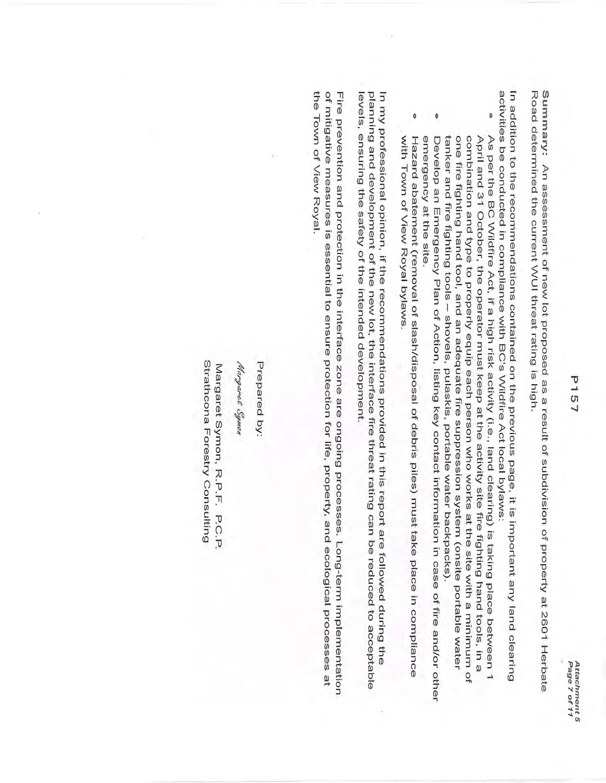
Summary: An assessment of new lot proposed as a result of subdivision of property at 2601 Herbate Road determined the current WUI threat rating is high.
In addition to the recommendations contained on the previous page, it is important any land clearing activities be conducted in compliance with BC's Wildfire Act local bylaws:
- As per the BC Wildfire Act, if a high risk activity (i.e., land clearing) is taking place between 1 April and 31 October, the operator must keep at the activity site fire fighting hand tools, in a combination and type to properly equip each person who works at the site with a minimum of one fire fighting hand tool, and an adequate fire suppression system (onsite portable water tanker and fire fighting tools – shovels, pulaskis, portable water backpacks).
- Develop an Emergency Plan of Action, listing key contact information in case of fire and/or other emergency at the site.
- Hazard abatement (removal of slash/disposal of debris piles) must take place in compliance with Town of View Royal bylaws.
In my professional opinion, if the recommendations provided in this report are followed during the planning and development of the new lot, the interface fire threat rating can be reduced to acceptable levels, ensuring the safety of the intended development.
Fire prevention and protection in the interface zone are ongoing processes. Long-term implementation of mitigative measures is essential to ensure protection for life, property, and ecological processes at the Town of View Royal.
Prepared by: Margaret Symon Margaret Symon, R.P.F. P.C.P. Strathcona Forestry Consulting
Appendix 1. FireSmart Interface Priority Zones
In interface areas, FireSmart advocates the establishment and maintenance of Fuel Management Zones* extending outward from structures and along access routes:
- Priority Zone 1 (0-10 m).
- Priority Zone 2 (10-30 m).
- Priority Zone 3 (30-100 m).

Priority Zone 1 (0-10 m): The main objective of vegetation management is to create an environment that will not support fire. Vegetation management focuses on fuel removal, conversion, and reduction.
Priority Zone 2 (10-30 m): Where treatment in PZ 1 is not sufficient to significantly reduce the fire hazard due to fuel loading, extend the fuel modified area with a variety of thinning and pruning actions.
Priority Zone 3 (30-100 m): Where fuel modification in PZ1 and PZ2 is insufficient to protect structures and/or property, FireSmart advocates treatment in Priority Zone 3 with a variety of thinning and pruning actions in order to create an environment that will not support high-intensity crown fires.
*Setback Zone distances may be extended depending on aspect, slope, fuel loading, etc.
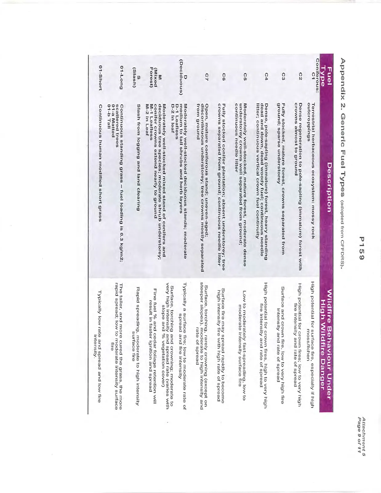
Appendix 2. Generic Fuel Types (adopted from CFFDRS).
| Fuel Type | Description | Wildfire Behaviour Under High Wildfire Danger |
|---|---|---|
| Coniferous: C1 | Terrestrial herbaceous ecosystem: mossy rock outcroppings | High potential for surface fire, especially if high moss/lichen |
| C2 | Dense regeneration to pole-sapling (immature) forest with crowns almost to ground | High potential for crown fires; low to very high fire intensity and rate of spread |
| C3 | Fully stocked, mature forest, crowns separated from ground; sparse understorey | Surface and crown fire, low to very high fire intensity and rate of spread |
| C4 | Dense, pole-sapling (immature) forest, heavy standing dead and down, dead woody fuel; continuous needle litter; continuous vertical crown fuel continuity | High potential for crown fires, high to very high fire intensity and rate of spread |
| C5 | Moderately well-stocked, mature forest, moderate dense understorey crowns well separated from ground; continuous needle litter | Low to moderately fast-spreading, low to moderate intensity surface fire |
| C6 | Fully stocked conifer plantation; absent understorey; tree crowns separated from ground; continuous needle litter | Surface fire may spread rapidly to become high intensity fire with high rate of spread |
| C7 | Open, mature coniferous stand; uneven-aged; discontinuous understorey; tree crowns mostly separated from ground | Surface, torching, rarely crowning (except on steeper slopes), moderate to high intensity and rate of spread |
| D (Deciduous) | Moderately well-stocked deciduous stands; moderate medium to tall shrubs and herb layers D-1 Leafless D-2 In leaf |
Typically a surface fire; low to moderate rate of spread and fire intensity |
| M (Mixed Forest) | Moderately well-stocked mixed stand of conifers and deciduous tree species; moderate shrub understorey; conifer crowns extend nearly to ground M-1 Leafless M-2 In Leaf |
Surface, torching and crowning; moderate to very high intensity and spread rate (varies with slope and % vegetation cover) Fine fuel % and cedar foliage retention will result in faster ignition and spread |
| S (Slash) | Slash from logging and land clearing | Rapid spreading, moderate to high intensity surface fire |
| O1-Long | Continuous standing grass - fuel loading is 0.3 kg/m2; scattered trees O1-a Matted O1-b Tall |
The taller, and more cured the grass, the more rapid spread; low to moderate intensity surface fire |
| O1-Short | Continuous human modified short grass | Typically low rate and spread and low fire intensity. |
Appendix 3. Photos.
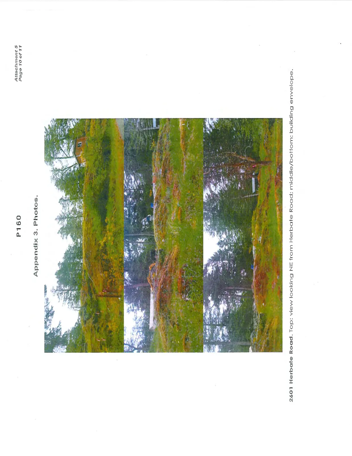
2601 Herbate Road. Top: view looking NE from Herbate Road; middle/bottom: building envelope.
Limitations
This report provides an assessment of WUI hazard and risk. Evaluation is based on professional judgment. The investigation involved a field observation. Recommended treatment pertains only to the particular site as disclosed at the time of inspection. The report was prepared considering site-specific circumstances and conditions. It is intended only for use by the client for the purpose for which it was commissioned and for use by local government regulating the activities to which it pertains.
Document Images
(7)