Aqua-Tex Scientific Consulting: Biological Assessment – 263 View Royal Avenue
Ecological review of the shoreline impact of the proposed deck addition.
To: Jeff Chow, MCIP, CPP, Senior Planner, Town of View Royal CC: Giuseppe Martino, Homeowner Lot 6, Block 13, Section 27, Esquimalt District, Plan 1688 (262 View Royal Avenue) From: Wm. Patrick Lucey, B.Sc., B.A., M.Sc., R.P. Bio., CBiol., MSB, Sr. Aquatic Ecologist Tracy Motyer, B.Sc., RB Tech., Aquatic Technologist Date: June 3rd, 2015 Re: Proposed deck construction within Shoreline Development Permit Area File: 1TB:Users:Patrick:Documents:Projects:263 View Royal Avenue Martino:RiparianDPDeckCottage150602.doc
Dear Jeff:
Aqua-Tex has been retained by Mr. Giuseppe (Joe) Martino, the Homeowner at 263 View Royal Avenue, to review the potential effect(s) on foreshore riparian health of a deck attached to a small cottage, adjacent to the marine shoreline. The following are our observations made during a site visit June 1, 2015, and recommendations arising from that site visit. I would be pleased to discuss our findings and recommendations with you at your convenience should you have any questions.
- Our site review has lead to our recommendation that, if constructed as recommended, the proposed deck will not have any adverse effects on the riparian vegetation and should be a permitted structure within the Development Permit Area.
Background
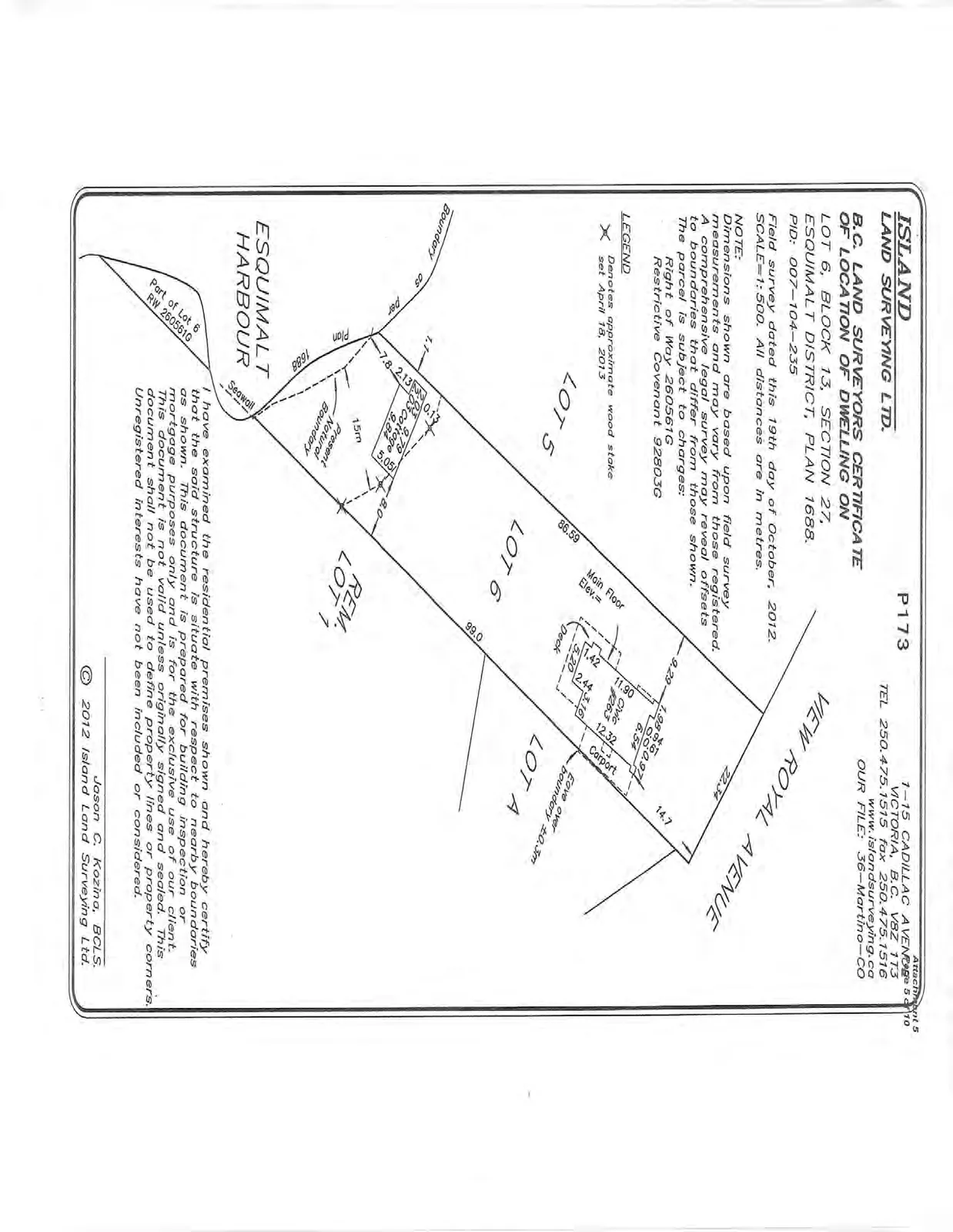
The site has two residential dwellings – shown in the appended survey drawing – including a small cottage adjacent to the marine foreshore. A narrow trail leads from the upper elevation of the site, adjacent to the main house, to the shoreline and provides access to the cottage and the beach.
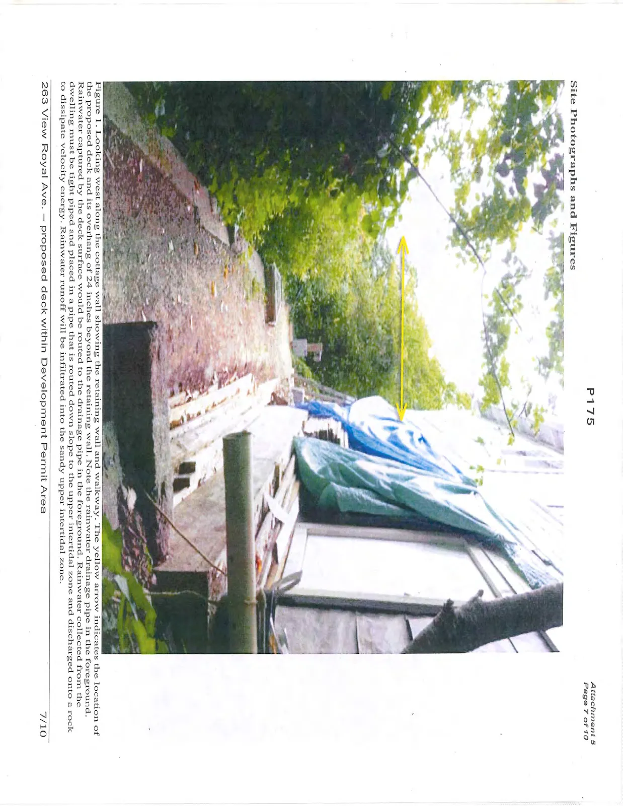
The cottage is being renovated and the homeowner has requested authorization to install a deck projecting beyond the dwelling on the southern side of the cottage. The proposed deck would project over an existing retaining wall and would extend approximately 24 inches beyond the retaining wall over the riparian vegetation. The proposed deck location is within the Shoreline DP Area, which requires an assessment of the effect of the deck on the riparian plant community health and its functional condition.
The following are our observations and findings with respect to the proposed deck installation and rainwater management considerations; observations on the trail are also included. Recommendations arising from the site visit are included at the end of the memo; photographs of the site relating to the deck, rainwater management, and trail are appended at the end of the memo.
Observations and Findings
The cottage lies within the 15-metre shoreline setback approximately parallel to the marine shoreline (see site survey drawing). The cottage has a concrete retaining wall seaward of the dwelling foundation, with a narrow walkway between the dwelling wall and the retaining wall (Figure 1). Discussion with the homeowner indicated a Geotechnical Engineer, with Ryzuk Geotechnical, confirmed the retaining wall is structurally sound and the deck supports can be located within the walkway provided the deck support posts are placed on bearing ground material.
The image in Figure 1 shows the proposed deck height and width (approximately 2 metres beyond the dwelling wall). Note that the deck will be well above the riparian vegetation, consisting of a medium height shrub plant community (2 metres in height, measured from the ground); the deck will not shade the vegetation given the southern aspect of the dwelling. The deck will extend beyond the walking path by approximately 24 inches and, thus, will not interfere with rainwater falling on the plants – the deck would not create a dry soil condition adjacent to the retaining wall by reducing soil moisture. Historical soil moisture conditions will be maintained as the majority of the rainfall consists of on-shore winds coming from the south.
Given that the existing cottage dwelling lies within the 15-metre shoreline setback, the proposed deck would also lie within this management zone. The site review sought to address the question of whether the deck would result in adverse effects on the riparian vegetation, would be a neutral structure, or would provide benefits to the steep slope plant community and slope soils.
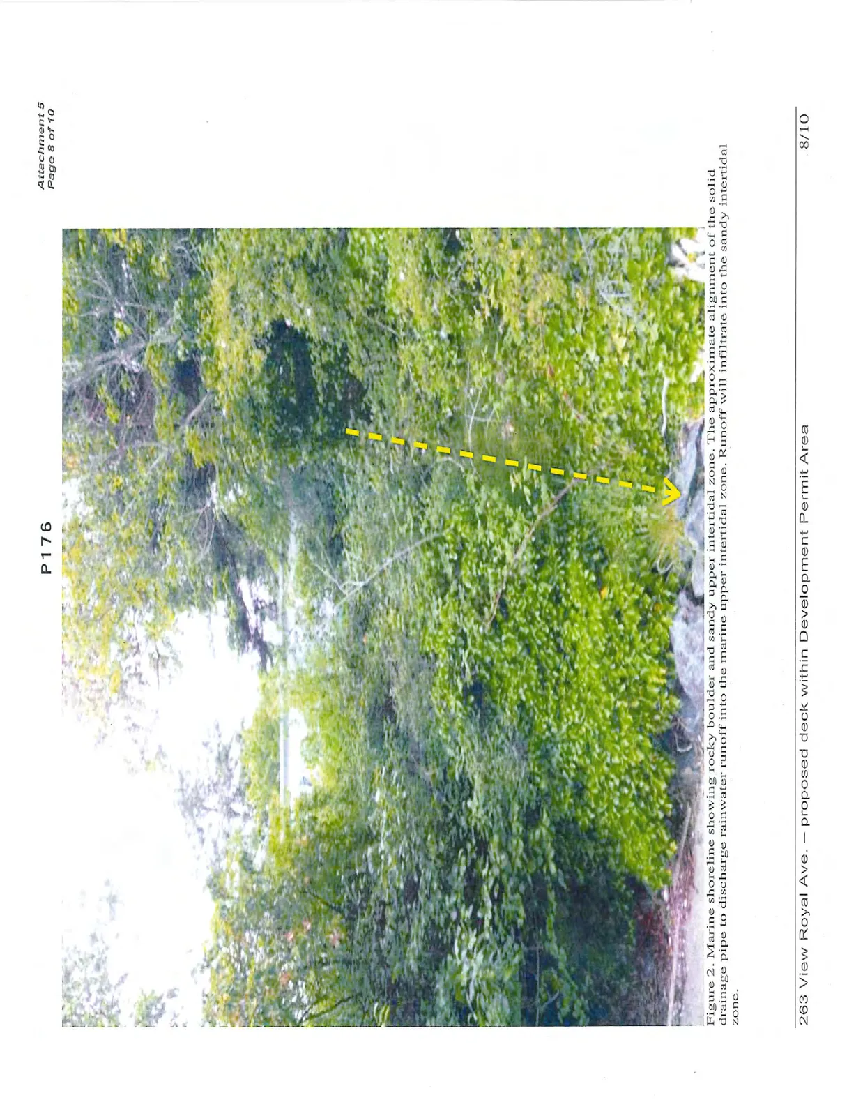
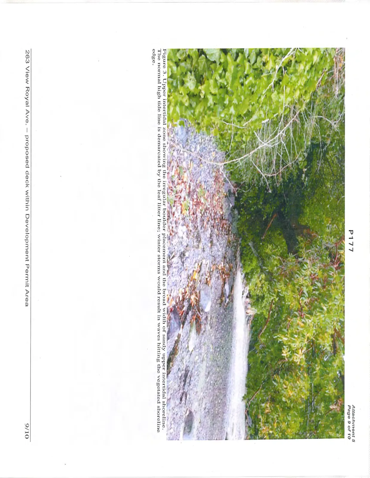
The deck surface will capture rainwater keeping the walkway dry. The deck is proposed to be sloped to the east with a drainage pipe at the eastern end of the deck. The rainwater runoff flow from the deck must be connected to the peripheral drainage pipe (Figure 1) and all drainage flows routed into a solid pipe placed on the surface of the slope leading to the upper intertidal zone. Runoff discharge must be discharged onto a rock to break up energy and permit runoff to infiltrate into the sandy shoreline (Figure 2; Figure 3). The rainwater from the dwelling roof, recently re-shingled with asphalt shingles, should be captured via roof gutters and downspouts routed into the solid piping leading to the marine shoreline. Rainwater runoff must not be permitted to be discharged directly onto the steep slope soils as that would result in soil erosion, potential slope slumping, and a loss of slope vegetation. The dense vegetation, and their root systems, on the slope are providing important soil stability.
The rainwater runoff from the dwelling roof and deck does not contain any significant pollutants and, thus, does not require treatment. The perimeter drainage runoff consists of near surface runoff from the surrounding soils and does not require treatment. Since the runoff from the cottage dwelling site is being discharged directly into the upper intertidal zone there are no marine shoreline erosion concerns; the runoff velocity can be dissipated by discharging the flows onto an existing boulder (Figure 2). The solid drainage pipe should be laid directly onto the slope soils and not buried in a trench as constructing the trench would result in the disturbance of vegetation roots and could destabilize slope soils. The upper intertidal sandy materials are restructured with each high tide cycle and freshwater runoff (surficial and near surface ground water) from the adjacent slopes discharges into the upper intertidal as part of the natural hydrological process.
The vegetation on the banks (Table 1), especially that adjacent to the marine shoreline (Figure 3) provides important nutrient inputs and food resources for marine fisheries that use the upper intertidal zone during high water periods. This is an important nutrition resource zone for forage fish, salmonids smolts and other small fish. The slope vegetation consists of a mixed plant community (Table 1) with a number of invasive species. The homeowner has been cutting ivy growing on trees on the site and it is recommended that this management practice be continued.
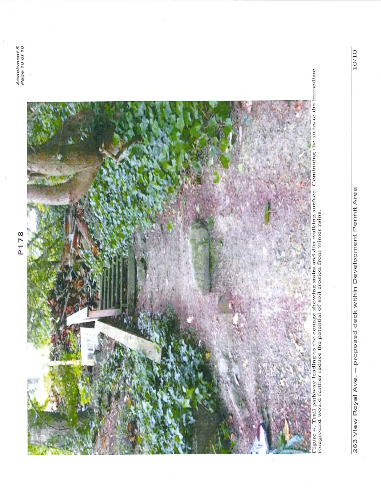
The trail leading to the cottage consists of a set of stairs and a dirt path (Figure 4). The over hanging tree canopy functions to intercept rainwater, preventing erosion of the pathway. No evidence of erosion from rainwater runoff was noted and it is recommended that where practical stairs be constructed to further reduce the potential for erosion by rainwater runoff.
Recommendations
- The proposed deck will not adversely affect the slope vegetation, will not interfere with plant growth, will not result in a loss of rainwater to reduce soil moisture, and will maintain slope vegetation root systems to stabilize slope soils.
- The deck should be permitted to be constructed as recommended.
- The deck must have rainwater routed directly into a solid drainage pipe, also capturing perimeter drainage flows, and be discharged directly into the upper intertidal zone’s sandy materials.
- The rainwater drainage runoff must be discharged directly onto a boulder at the upper extremity of the sandy shoreline.
- Trail steps can be constructed to further minimize runoff erosion potential.
Site Survey Drawing
Plant List
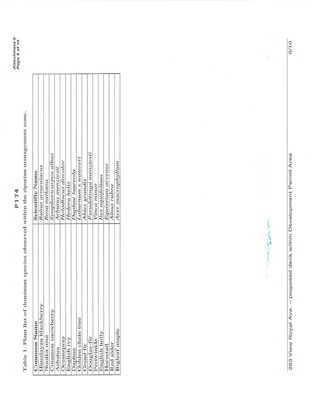
Table 1. Plant list of dominant species observed within the riparian management zone.
| Common Name | Scientific Name |
|---|---|
| Himalayan blackberry | Rubus armeniacus |
| Nootka rose | Rosa nutkana |
| Common snowberry | Symphoricarpos albus |
| Arbutus | Arbutus menziesii |
| Oceanspray | Holodiscus discolor |
| English ivy | Hedera helix |
| Daphne | Daphne laureola |
| Golden chain tree | Laburnum x watereri |
| Grand fir | Abies grandis |
| Douglas-fir | Pseudotsuga menziesii |
| Periwinkle | Vinca minor |
| English holly | Ilex aquifolium |
| Horsetail | Equisetum arvense |
| Red alder | Alnus rubra |
| Bigleaf maple | Acer macrophyllum |
Site Photographs and Figures
Document Images
(5)