Staff Report: Development Permit No. 2015/06 – 290 Wilfert Road (COHO Phase 2)
Senior Planner report recommending approval of amendments to the site and landscaping plans for COHO Phase 2.
TOWN OF VIEW ROYAL
Council Report
TO: Mayor and Council DATE: June 10, 2015 FROM: J. Chow, Senior Planner MEETING DATE: June 16, 2015 FILE NO.: 3060-20-2015/06
DEVELOPMENT PERMIT NO. 2015/06 - 290 WILFERT ROAD (COHO PHASE 2)
RECOMMENDATIONS:
That Development Permit 2015/06 be approved.
CHIEF ADMINISTRATIVE OFFICER'S COMMENTS:
I concur with the recommendation.
DIRECTOR OF DEVELOPMENT SERVICES' COMMENTS:
I concur with the recommendation.
PURPOSE OF REPORT:
The purpose of this report is to present an application to amend Development Permit 2010/06 to allow changes to parking and landscaping. No variances are required.
BACKGROUND:
The subject property is a 2.16 ha (5.34 ac) property located on a rocky bluff behind a commercial plaza on Island Highway whose tenants include Burger King and McKays Electronic Experts. The site is bordered on the east by residential properties on Lloyd Place to the east and on the south by Department of National Defence (DND) lands that are in the City of Colwood.
Development Permit 2010/06 was approved in June 2010 to construct 98 units of multifamily housing comprised of two 49-unit four storey apartment condominium buildings connected by underground parking. Several development permit amendments were subsequently approved for the following:
- Site modifications to create a lower slope adjacent to the driveway (due to unstable rock);
- Refinements to outdoor amenity spaces in Phase 1; and
- Form and Character development permit for Phase 2, reducing the number of units from 49 to 44.
The Phase 1 building is complete. The Phase 2 building is under construction. The proposal was introduced at the June 9, 2015 Committee of the Whole meeting.
PROPOSAL:
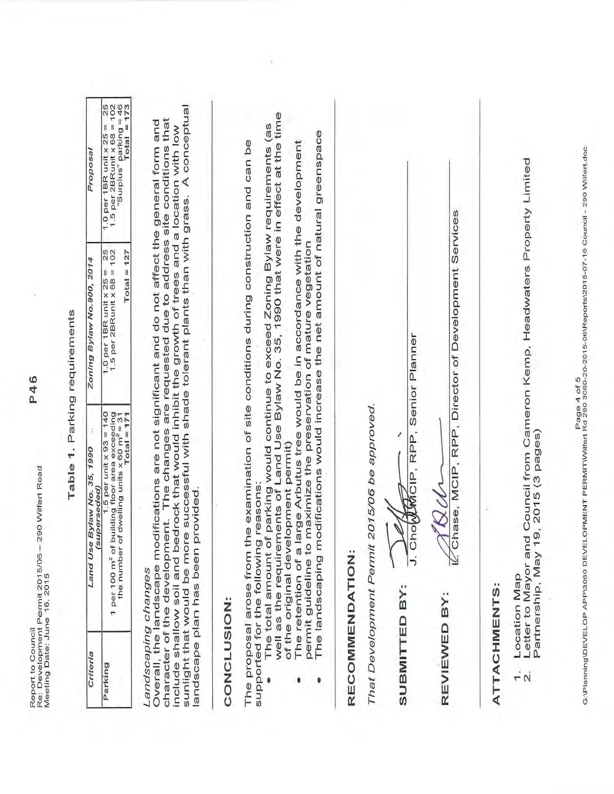
The proposal is to amend the site and landscaping plans for Phase 2, which is the second and final building of the Coho Condominiums multifamily residential development. Requested changes of note are shown in Figure 1 and Attachments 2-10 and include the following:
- Reduction of total parking from 177 to 173 spaces (147 required);
- Relocation of 8 to 15 proposed trees from north and south ends of the Phase 2 building to central landscaping area;
- Replacement of approximately 60 m² of lawn on top of the parking structure at the northeast end of the Phase 2 building with shade tolerant plants; and
- Replacement of approximately 35m² of lawn on top of the parking structure at the north end of the Phase 2 building with an expanded patio area.
No changes to the buildings are proposed.
ANALYSIS:
The key issues include: A. How does the proposal address the development permit area guidelines? B. Are the proposed changes supportable?
A. Development Permit Area Guidelines
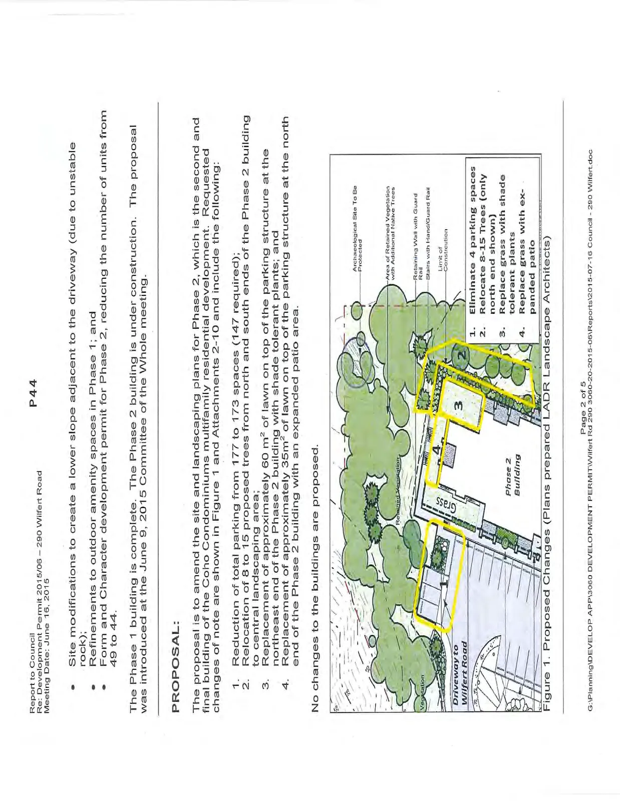
The only issue relating to the relevant Mixed Residential Development Permit Area guidelines is the elimination of four parking spaces. This would allow a large Arbutus tree (Figure 1) to be retained, which is supported by the guidelines. If the proposal is not supported, construction of the parking spaces would require retaining structures in the root zone of the tree, likely necessitating its removal.
B. Are the proposed changes supportable?
Elimination of Four Parking Spaces
As shown in Table 1, the elimination of four parking spaces would leave the site with total parking that would continue to exceed requirements of both the current Zoning Bylaw and the superseded Land Use Bylaw. The reason for the excess parking is that the Development Permit 2010/06 was originally approved for 98 units, which has since been reduced to 93 units with Phase 2.
Table 1. Parking requirements
| Criteria | Land Use Bylaw No. 35, 1990 (superseded) | Zoning Bylaw No. 900, 2014 | Proposal |
|---|---|---|---|
| Parking | 1.5 per unit x 93 = 140 1 per 100 m² of building floor area exceeding the number of dwelling units x 60 m² = 31 Total = 171 |
1.0 per 1BR unit x 25 = 25 1.5 per 2BR unit x 68 = 102 Total = 127 |
1.0 per 1BR unit x 25 = 25 1.5 per 2BR unit x 68 = 102 "Surplus" parking = 46 Total = 173 |
Landscaping changes
Overall, the landscape modifications are not significant and do not affect the general form and character of the development. The changes are requested due to address site conditions that include shallow soil and bedrock that would inhibit the growth of trees and a location with low sunlight that would be more successful with shade tolerant plants than with grass. A conceptual landscape plan has been provided.
CONCLUSION:
The proposal arose from the examination of site conditions during construction and can be supported for the following reasons:
- The total amount of parking would continue to exceed Zoning Bylaw requirements (as well as the requirements of Land Use Bylaw No. 35, 1990 that were in effect at the time of the original development permit)
- The retention of a large Arbutus tree would be in accordance with the development permit guideline to maximize the preservation of mature vegetation
- The landscaping modifications would increase the net amount of natural greenspace
RECOMMENDATION:
That Development Permit 2015/06 be approved.
SUBMITTED BY: J. Chow, MCIP, RPP, Senior Planner
REVIEWED BY: L. Chase, MCIP, RPP, Director of Development Services
ATTACHMENTS:
- Location Map
- Letter to Mayor and Council from Cameron Kemp, Headwaters Property Limited Partnership, May 19, 2015 (3 pages)
Document Images
(2)