Transportation Impact Assessment - Hallowell Road / E&N Trail
A detailed engineering assessment of the traffic impacts related to removing weight restrictions and completing the rail trail.
Hallowell Road – E&N Trail
Town of View Royal, B.C.
Transportation Impact Assessment
FINAL REPORT
Prepared For: Capital Regional District
Prepared By: Adept Transportation Solutions
June 18, 2015
Adept Transportation Solutions 2426 Mill Bay Road, Mill Bay, BC V0R 2P4 (778) 678-1020
Table of Contents
- INTRODUCTION ................................................................................................. 2
- BACKGROUND ................................................................................................... 2
- PROJECT DEFINITION ........................................................................................ 3
- STUDY AREA .................................................................................................... 4
- PROJECT METHODOLOGY ................................................................................. 4
- EXISTING CONDITIONS ...................................................................................... 5
- ROADS / INTERSECTIONS .................................................................................. 5
- TRAFFIC VOLUMES .......................................................................................... 7
- CYCLING TRAFFIC VOLUMES ........................................................................... 11
- TRUCKING ..................................................................................................... 11
- ANALYSIS ........................................................................................................ 13
- THETIS COVE DEVELOPMENT ......................................................................... 13
- TRIO LANDSCAPE SUPPLY ............................................................................... 14
- ESQUIMALT NATION TRAFFIC ........................................................................ 15
- TOTAL FUTURE TRAFFIC ON HALLOWELL ROAD .............................................. 15
- PERFORMANCE MEASURES ............................................................................ 15
- Volume to Capacity (v/c) ........................................................................... 15
- Level of Service (LOS) ................................................................................ 16
- EXISTING INTERSECTION PERFORMANCE ......................................................... 18
- FUTURE TOTAL TRAFFIC INTERSECTION PERFORMANCE ................................. 19
- MODAL SHIFT TO E&N RAIL TRAIL ................................................................. 20
- CONCLUSION ................................................................................................... 20
- RECOMMENDATIONS ....................................................................................... 21
INTRODUCTION
At the request of the Capital Regional District (CRD), Adept Transportation Solutions (Adept) has been engaged to undertake an assessment of the impacts to the Hallowell Road area adjacent local road network as a result of the potential closure of Thomas Road that is being considered due to the Admirals Road upgrades currently planned by the Ministry of Transportation & Infrastructure.
BACKGROUND
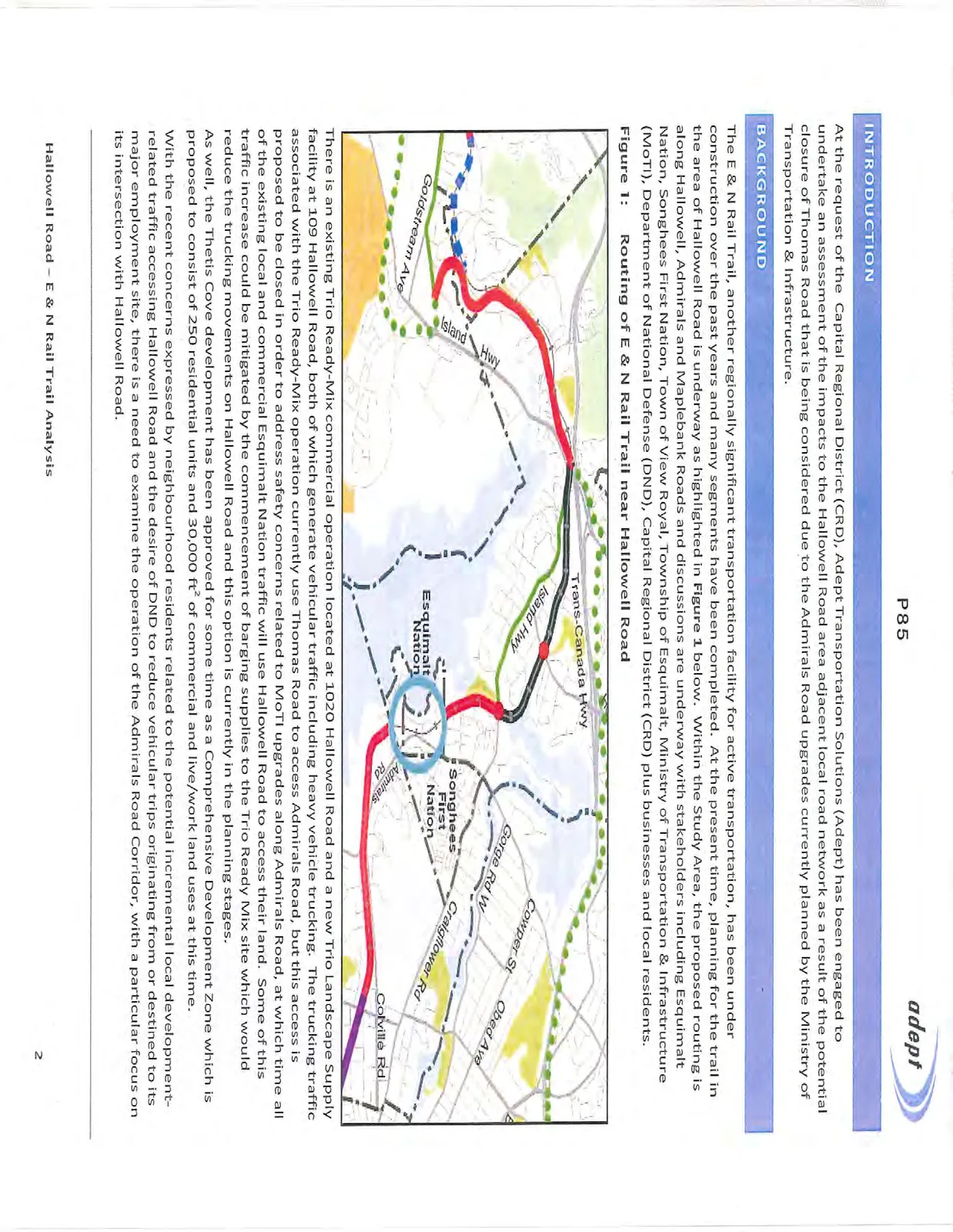
The E & N Rail Trail, another regionally significant transportation facility for active transportation, has been under construction over the past years and many segments have been completed. At the present time, planning for the trail in the area of Hallowell Road is underway as highlighted in Figure 1 below. Within the Study Area, the proposed routing is along Hallowell, Admirals and Maplebank Roads and discussions are underway with stakeholders including Esquimalt Nation, Songhees First Nation, Town of View Royal, Township of Esquimalt, Ministry of Transportation & Infrastructure (MoTI), Department of National Defense (DND), Capital Regional District (CRD) plus businesses and local residents.
There is an existing Trio Ready-Mix commercial operation located at 1020 Hallowell Road and a new Trio Landscape Supply facility at 109 Hallowell Road, both of which generate vehicular traffic including heavy vehicle trucking. The trucking traffic associated with the Trio Ready-Mix operation currently use Thomas Road to access Admirals Road, but this access is proposed to be closed in order to address safety concerns related to MoTI upgrades along Admirals Road, at which time all of the existing local and commercial Esquimalt Nation traffic will use Hallowell Road to access their land. Some of this traffic increase could be mitigated by the commencement of barging supplies to the Trio Ready Mix site which would reduce the trucking movements on Hallowell Road and this option is currently in the planning stages.
As well, the Thetis Cove development has been approved for some time as a Comprehensive Development Zone which is proposed to consist of 250 residential units and 30,000 ft² of commercial and live/work land uses at this time.
With the recent concerns expressed by neighbourhood residents related to the potential incremental local development-related traffic accessing Hallowell Road and the desire of DND to reduce vehicular trips originating from or destined to its major employment site, there is a need to examine the operation of the Admirals Road Corridor, with a particular focus on its intersection with Hallowell Road.
PROJECT DEFINITION
The focus of the project is to address the transportation-related impacts from the following changes:
- Increased traffic on Hallowell Road generated from:
- Trio Landscape Supply;
- re-routed local Esquimalt Nation traffic from Thomas to Hallowell Roads which would include Trio Ready-Mix traffic; and
- the mixed-use Thetis Cove development;
- This would include the effect of the incremental traffic from Hallowell Road on the Aldersmith Place / Cooper Road / Admirals Road intersection in terms of operational performance as it is the only unsignalized intersection between Craigflower Road and Hallowell Road; and
- Potential conversion of single-occupant vehicles (SOV) to cycling trips on the E & N Rail Trail and the impact on Level of Service at the Admirals Road intersections.
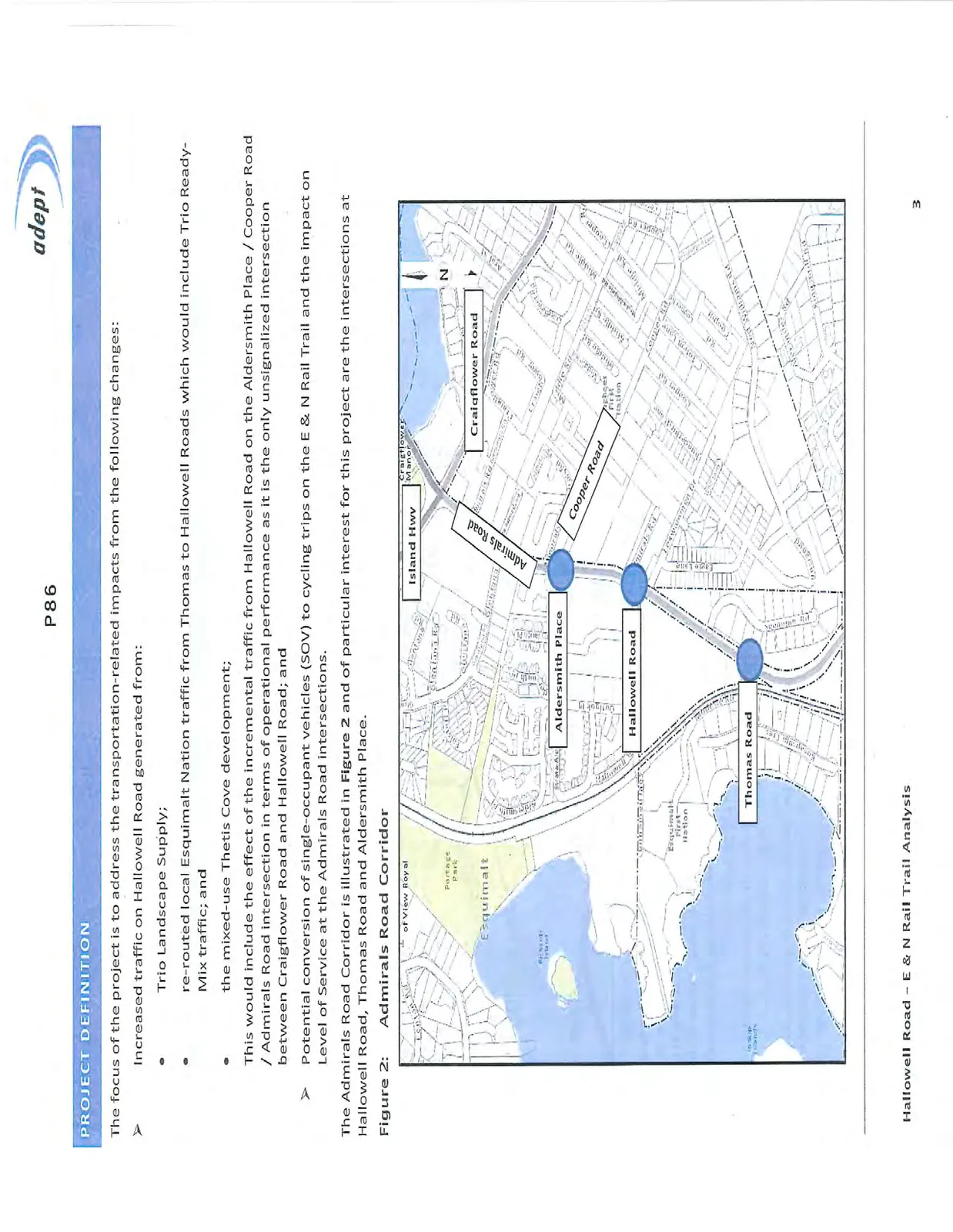
The Admirals Road Corridor is illustrated in Figure 2 and of particular interest for this project are the intersections at Hallowell Road, Thomas Road and Aldersmith Place.
STUDY AREA
While the Admirals Road corridor is illustrated in Figure 2, the focus of this study is the intersections of Thomas Road, Hallowell Road and Aldersmith Place / Cooper Road with Admirals Road.
PROJECT METHODOLOGY
A summary of the project methodology included the following tasks / activities:
- Data Acquisition / Review:
- Acquire relevant reports / documentation with respect to vehicular traffic volumes in the Admirals Road Corridor including the previous reports on the Thetis Cover development and Admirals Road Corridor Study undertaken for MoTI in 2009 by MMM Group;
- Conduct traffic volume movement counts at Thomas Road, Hallowell Road, Aldersmith Place and Craigflower Road - Island Highway intersections with Admirals Road. Counts to be scheduled to cover the AM and PM peak periods. Counts at Thomas and Hallowell Roads are also to include existing gravel / concrete truck movements as well as non-commercial local traffic; and
- Acquire information about existing trucking movements on Hallowell Road and the operation of Trio Ready Mix and Trio Landscape Supplies. There is the potential for barging materials for Trio Ready Mix but it is not known at this time when or if that option could be implemented.
- Update Traffic Models
- Compile and analyze traffic volume data acquired to identify Average Weekday AM and PM Peak Hours and update traffic models to reflect current traffic volumes which would include Trio Ready Mix and Trio Landscape Supplies traffic / trucking volumes; and
- Calibrate model and generate intersection performance measures for baseline conditions.
- Analysis
- After models are developed and calibrated, run models with Thetis Cove traffic volumes included to compare intersection operation performance;
- If necessary, run models including re-routed traffic volumes to Hallowell Road associated with the closure of Thomas Road; and
- Undertake sensitivity analysis related to modal shifts of converting SOV (DND employees) to cyclists using the E & N Rail Trail.
- Reporting
- Compile project process and results in a Draft written report for Client review and comment by June 10, 2015 with the Final Report to be provided by June 13, 2015.
EXISTING CONDITIONS
It is first necessary to understand the operation of the Admirals Road Corridor which has been studied many times over the past years for various proposed land use developments as well as operational issues along the corridor related to congestion as well as accident rates¹. The following sections detail the analysis of recent vehicular, cycling and trucking traffic volume data in the Admirals Road corridor and using the Study Area intersections.
ROADS / INTERSECTIONS
The primary roads of interest in this study are Admirals Road, Hallowell Road, Aldersmith Place / Cooper Road and Thomas Road. The following section provides more details about these components of the local road network.
Admirals Road
Admirals Road between Craigflower Road – Island Highway and Maplebank Road is under the jurisdiction of MoTI and is classified as a Provincial Arterial. The cross-section of Admirals Road in the southbound (SB) direction is 2 travel lanes south of Craigflower Road – Island Highway to Hallowell Road where the curb lane becomes a right turn (RT) lane. South of Hallowell Road there is a single SB lane. There are separate LT lanes at Glentana Road as well as Aldersmith Place – Cooper Road and separate RTs lanes into Canadian Tire and Nelson Square.
In the northbound (NB) direction, there is a single NB lane south of Hallowell Road up to Craigflower Road – Island Highway. There are separate LT lanes at Hallowell Road, Aldersmith Place – Cooper Road and Glentana Road with double LT lanes as Craigflower Road – Island Highway. There are no separate RT lanes and the NB lane at Craigflower Road – Island Highway is a shared through – RT lane.
Hallowell Road
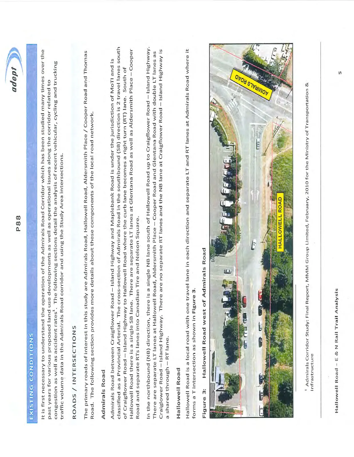
Hallowell Road is a local road with one travel lane in each direction and separate LT and RT lanes at Admirals Road where it forms a T intersection as shown in Figure 3.
¹ Admirals Corridor Study: Final Report, MMM Group Limited, February, 2010 for the Ministry of Transportation & Infrastructure
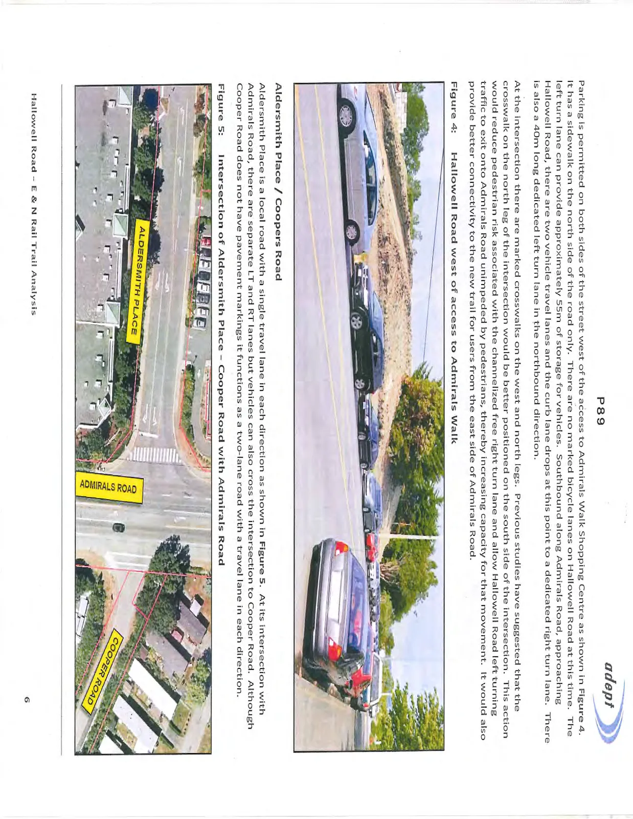
Parking is permitted on both sides of the street west of the access to Admirals Walk Shopping Centre as shown in Figure 4. It has a sidewalk on the north side of the road only. There are no marked bicycle lanes on Hallowell Road at this time. The left turn lane can provide approximately 55m of storage for vehicles. Southbound along Admirals Road, approaching Hallowell Road, there are two vehicle travel lanes and the curb lane drops at this point to a dedicated right turn lane. There is also a 40m long dedicated left turn lane in the northbound direction.
At the intersection there are marked crosswalks on the west and north legs. Previous studies have suggested that the crosswalk on the north leg of the intersection would be better positioned on the south side of the intersection. This action would reduce pedestrian risk associated with the channelized free right turn lane and allow Hallowell Road left turning traffic to exit onto Admirals Road unimpeded by pedestrians, thereby increasing capacity for that movement. It would also provide better connectivity to the new trail for users from the east side of Admirals Road.
Aldersmith Place / Coopers Road
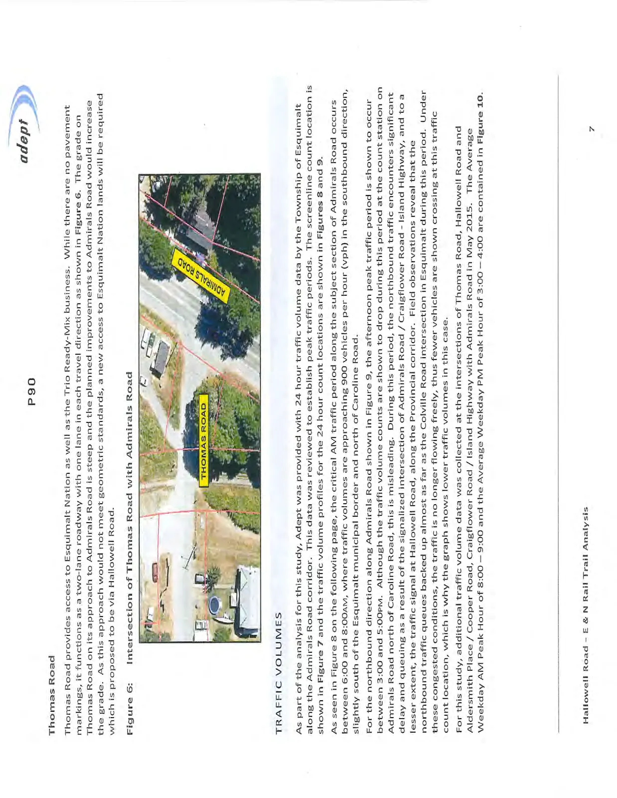
Aldersmith Place is a local road with a single travel lane in each direction as shown in Figure 5. At its intersection with Admirals Road, there are separate LT and RT lanes but vehicles can also cross the intersection to Cooper Road. Although Cooper Road does not have pavement markings it functions as a two-lane road with a travel lane in each direction.
Thomas Road
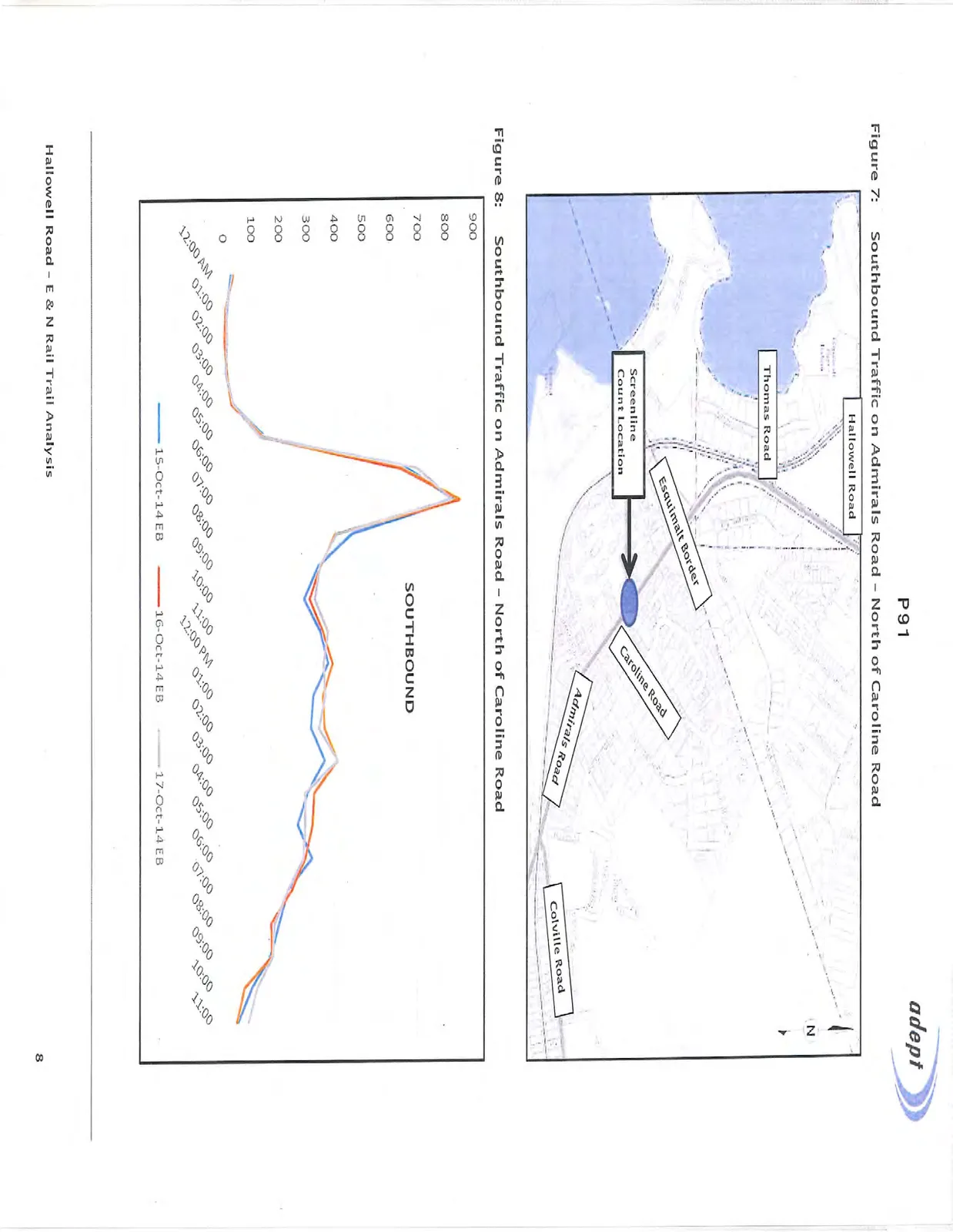
Thomas Road provides access to Esquimalt Nation as well as the Trio Ready-Mix business. While there are no pavement markings, it functions as a two-lane roadway with one lane in each travel direction as shown in Figure 6. The grade on Thomas Road on its approach to Admirals Road is steep and the planned improvements to Admirals Road would increase the grade. As this approach would not meet geometric standards, a new access to Esquimalt Nation lands will be required which is proposed to be via Hallowell Road.
TRAFFIC VOLUMES
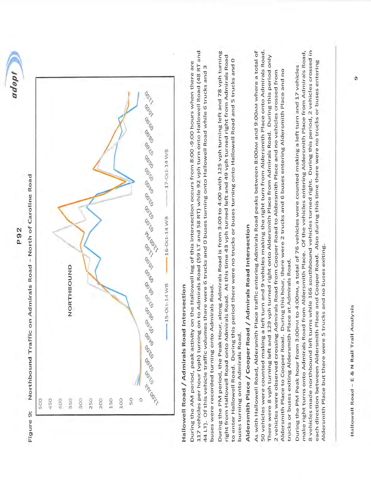
As part of the analysis for this study, Adept was provided with 24 hour traffic volume data by the Township of Esquimalt along the Admirals Road corridor. This data was reviewed to establish peak traffic periods. The screenline count location is shown in Figure 7 and the traffic volume profiles for the 24 hour count locations are shown in Figures 8 and 9.
As seen in Figure 8 on the following page, the critical AM traffic period along the subject section of Admirals Road occurs between 6:00 and 8:00AM, where traffic volumes are approaching 900 vehicles per hour (vph) in the southbound direction, slightly south of the Esquimalt municipal border and north of Caroline Road.
For the northbound direction along Admirals Road shown in Figure 9, the afternoon peak traffic period is shown to occur between 3:00 and 5:00PM. Although the traffic volume counts are shown to drop during this period at the count station on Admirals Road north of Caroline Road, this is misleading. During this period, the northbound traffic encounters significant delay and queuing as a result of the signalized intersection of Admirals Road / Craigflower Road - Island Highway, and to a lesser extent, the traffic signal at Hallowell Road, along the Provincial corridor. Field observations reveal that the northbound traffic queues backed up almost as far as the Colville Road intersection in Esquimalt during this period. Under these congested conditions, the traffic is no longer flowing freely, thus fewer vehicles are shown crossing at this traffic count location, which is why the graph shows lower traffic volumes in this case.
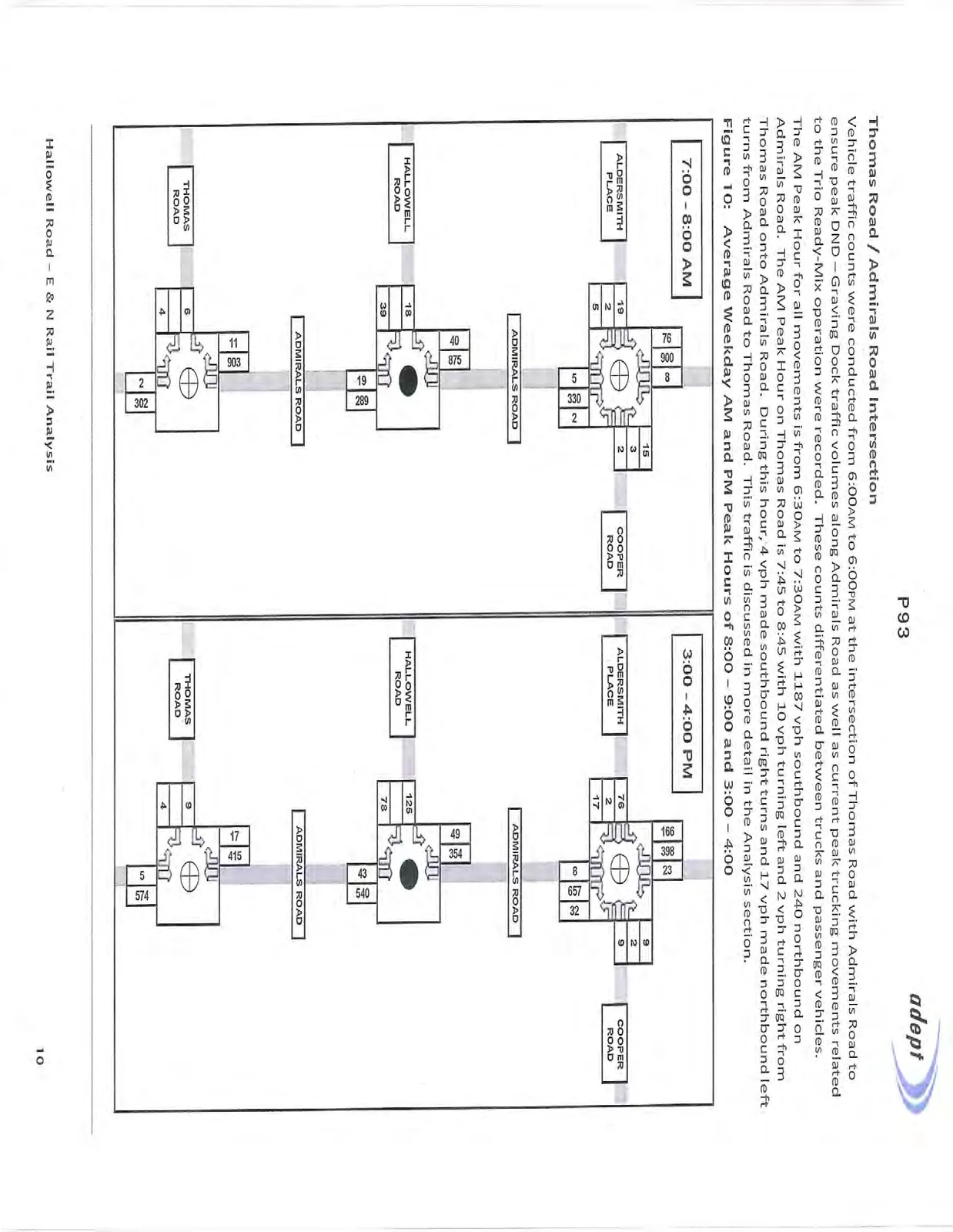
For this study, additional traffic volume data was collected at the intersections of Thomas Road, Hallowell Road and Aldersmith Place / Cooper Road, Craigflower Road / Island Highway with Admirals Road in May 2015. The Average Weekday AM Peak Hour of 8:00 – 9:00 and the Average Weekday PM Peak Hour of 3:00 – 4:00 are contained in Figure 10.
Hallowell Road / Admirals Road Intersection
During the AM period, peak activity on the Hallowell leg of this intersection occurs from 8:00 -9:00 hours when there are 117 vehicles per hour (vph) turning on to Admirals Road (59 LT and 58 RT) while 92 vph turn onto Hallowell Road (48 RT and 44 LT). Of this vehicle traffic volumes there were 6 trucks and 0 buses turning onto Hallowell Road while 6 trucks and 3 buses were recorded turning onto Admirals Road.
During the PM period, the Peak Hour, along Admirals Road is from 3:00 to 4:00 with 125 vph turning left and 78 vph turning right from Hallowell Road onto Admirals Road. At this time 43 vph turned left and 49 vph turned right from Admirals Road to enter Hallowell Road. During this period there were no trucks or buses turning onto Hallowell Road and 5 trucks and 0 buses turning onto Admirals Road.
Aldersmith Place / Cooper Road / Admirals Road Intersection
As with Hallowell Road, Aldersmith Place traffic entering Admirals Road peaks between 8:00AM and 9:00AM where a total of 50 vehicles were counted making a left turn and 9 vehicles making the right turn from Aldersmith Place onto Admirals Road. There were 8 vph turning left and 129 vph turned right onto Aldersmith Place from Admirals Road. During this period only 2 vehicles were observed crossing Admirals Road from Cooper Road to Aldersmith Place and no vehicles crossed from Aldersmith Place to Cooper Road. During this hour, there were 2 trucks and 6 buses entering Aldersmith Place and no trucks or buses exiting Aldersmith Place at Admirals Road.
During the PM Peak hour from 3:00PM to 4:00PM, a total of 76 vehicles were counted making a left turn and 17 vehicles make right turns onto Admirals Road from Aldersmith Place. Of the vehicles entering Aldersmith Place from Admirals Road, 8 vehicles made northbound left turns while 166 southbound vehicles turned right. During this period, 2 vehicles crossed in each direction between Aldersmith Place and Cooper Road. Also during this time there were no trucks or buses entering Aldersmith Place but there were 5 trucks and no buses exiting.
Thomas Road / Admirals Road Intersection
Vehicle traffic counts were conducted from 6:00AM to 6:00PM at the intersection of Thomas Road with Admirals Road to ensure peak DND – Graving Dock traffic volumes along Admirals Road as well as current peak trucking movements related to the Trio Ready-Mix operation were recorded. These counts differentiated between trucks and passenger vehicles.
The AM Peak Hour for all movements is from 6:30AM to 7:30AM with 1187 vph southbound and 240 northbound on Admirals Road. The AM Peak Hour on Thomas Road is 7:45 to 8:45 with 10 vph turning left and 2 vph turning right from Thomas Road onto Admirals Road. During this hour, 4 vph made southbound right turns and 17 vph made northbound left turns from Admirals Road to Thomas Road. This traffic is discussed in more detail in the Analysis section.
CYCLING TRAFFIC VOLUMES
Cyclist volumes along Hallowell Road and Admirals Road were recorded during the traffic counts. The data recorded, as described in more detail below, indicates that there are a significant number of cyclists currently commuting along the E&N Rail Trail alignment, including Hallowell Road during the AM and PM commuter peak periods. With the continued development of the E&N Rail Trail, it is likely that these numbers will increase over time as has been seen with the cycling traffic on the Galloping Goose Regional Trail.
Thomas Road
As discussed earlier, traffic volumes were collected between the hours of 6:00AM and 6:00PM in order to ensure the peak DND commuter traffic was captured along with the typical peak traffic. Over the course of the study period, 298 cyclists were recorded along Admirals Road in the southbound direction and 305 cyclists were recorded in the northbound direction past Thomas Road. During the AM Peak Period, 210 cyclists passed Thomas Road between 6:15AM and 7:45AM. In the northbound direction, 218 cyclists were recorded passing Thomas Road between 2:25PM and 5:00PM with a spike occurring between 4:00PM and 4:15PM with 101 cyclist recorded during that 15 minute period. Given the recorded activity, it is assumed that the majority of these cyclists could be attributed to DND / Shipyard employees.
Hallowell Road
During the observed AM Peak period (7:00AM – 9:00AM), 119cyclists were observed along Hallowell Road. Of these, 104 traveled eastbound and turned right onto Admirals Road while two cyclists turned left onto Admirals Road. No cyclists were recorded turning right onto Hallowell Road from Admirals Road and 4 cyclists were recorded turning left onto Hallowell Road from Admirals Road. 25 cyclists were recorded along Admirals Road in the southbound direction past Hallowell Road and 11 turned right from Admirals Road. In the northbound direction along Admirals Road, 11 cyclists were recorded passing Hallowell Road and 9 turned left onto Hallowell Road.
During the PM Peak observation period (4:00PM – 6:00PM), 239 cyclists were recorded along Hallowell Road. Of these, 186 turned left from Admirals Road, 0 turned right. 29 cyclists made a right turn from Hallowell Road onto Admirals Road and 14 turned left.
Along Admirals Road, 48 cyclists continued past Hallowell Road in the northbound direction and 12 cyclists passed in the southbound direction.
The data recorded indicates that there is a significant number of cyclists currently commuting along the E&N Rail Trail alignment, including Hallowell Road during the AM and PM commuter peak periods. With the continued development of the E&N Rail Trail, it is likely that these numbers will increase over time as has been seen with the Galloping Goose Regional Trail.
TRUCKING
The existing businesses with accesses on Hallowell Road that generate trucking movements are Thrifty Foods in the Admirals Walk Shopping Centre (1495 Admirals Road), Reliable Controls (120 Hallowell) and Trio Landscape Supplies (109 Hallowell). Trio Ready Mix has an address of 1020 Hallowell Road but its trucking traffic is currently routed to Admirals Road via Thomas Road. Of the existing truck traffic on Hallowell Road, most can be attributed to Thrifty Foods.
Thrifty Foods is within the Admirals Walk shopping centre but its receiving loading bays are accessed via Hallowell Road. They receive a variety of delivery vans / trucks in the 1 – 5 tonne range. As well, six Thrifty Foods semi tractors with 42 foot trailers per week typically deliver from 9:00PM to 10:00PM, outside of regular peak commuter traffic periods. Other trucks with up to 53 foot trailers deliver approximately 24 loads / week and begin deliveries at 6:00AM and cease by noon.
Reliable Controls has approximately 6 deliveries per day by the large cube vans used by UPS, Purolator and Fedex. A larger delivery truck will service their facility every one or two months.
Trio Landscape Supplies is a new commercial land use development on the southwest corner of the Admirals Road / Hallowell Road intersection which provides a full range of soils, mulch and aggregate products. It is expected to generate a maximum of 250 two-way trips per day when an Ellice Recycling Depot component is operational next year on the Esquimalt Nation site. Of these anticipated vehicle trips there could be an average or two tandem axle trucks delivering supplies per day and 1 walk-in trailer truck per week for hauling recyclable products.
The site has been designed to accommodate all anticipated traffic layby requirements on-site so there will be no queuing or storage on Hallowell Road. In addition, the site layout has been designed to accommodate a right-in / right-out access on Admirals Road which MoTI has indicated they have no objection to, but permission for such an access has not been requested at this time.
Trio Ready Mix provides ready mix concrete service and concrete related materials to its customers. It is located on Esquimalt Nation lands and is accessed from Admirals Road via its intersection at Thomas Road.
Trucking movements involve three different types of vehicles: B trains (80 feet long) for delivery of cement; quad tractors (50 feet long) for delivery of gravel and the tandem tandems which are standard concrete trucks. Average conditions would result in 1 to 2 cement B trains / day or 2 to 4 directional trips entering and exiting the site; 8 – 13 quad tractors / day or 16 – 26 directional trips; and 20 concrete trucks / day or 40 directional trips. The existing average weekday trucking volumes recorded at the Thomas Road / Admirals Road intersection are summarized in Figure 11 below and illustrate the volume of trucking traffic currently using Thomas Road. It should be noted that no trucks were recorded entering or exiting Thomas Road during the observation period of 3:00 – 6:00PM.
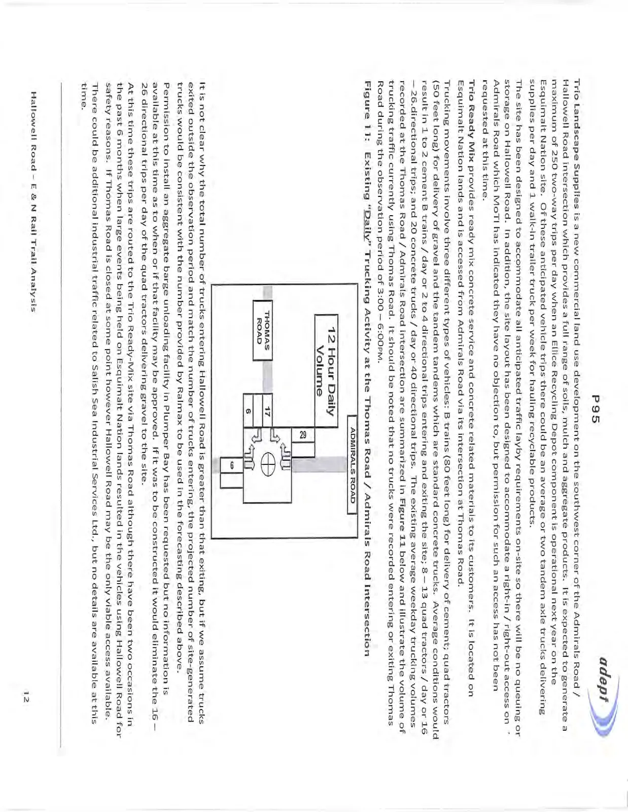
It is not clear why the total number of trucks entering Hallowell Road is greater than that exiting, but if we assume trucks exited outside the observation period and match the number of trucks entering, the projected number of site-generated trucks would be consistent with the number provided by Ralmax to be used in the forecasting described above.
Permission to install an aggregate barge unloading facility in Plumper Bay has been requested but no information is available at this time as to when or if that facility may be approved. If it was to be constructed it would eliminate the 16 – 26 directional trips per day of the quad tractors delivering gravel to the site.
At this time these trips are routed to the Trio Ready-Mix site via Thomas Road although there have been two occasions in the past 6 months when large events being held on Esquimalt Nation lands resulted in the vehicles using Hallowell Road for safety reasons. If Thomas Road is closed at some point however Hallowell Road may be the only viable access available. There could be additional industrial traffic related to Salish Sea Industrial Services Ltd., but no details are available at this time.
ANALYSIS
The traffic volumes associated with existing conditions are used in micro-simulation modeling software Synchro / SimTraffic to evaluate the operational performance of intersections in a road network or corridor. The outputs of the modeling software must be interpreted in the context of the operational conditions of the network and the impact that systemic congestion may have on vehicular delay and the network’s ability to accommodate vehicular traffic if the arrival rates at intersections are greater than the departure rates.
As well there are current or proposed land use developments which need to be evaluated in terms of their potential impact on the existing conditions such as the Thetis Cove development and the new Trio Landscape Supply business when it becomes fully operational. These land uses are discussed in more detail in the following sections.
THETIS COVE DEVELOPMENT
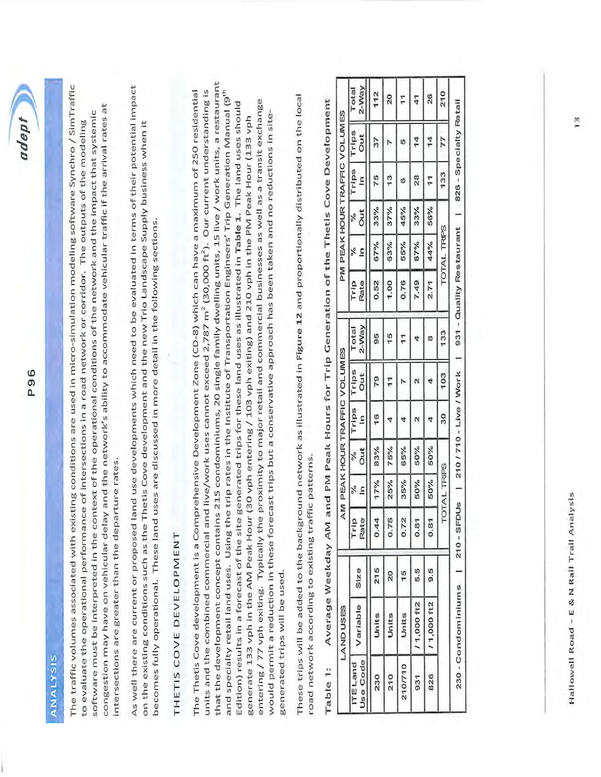
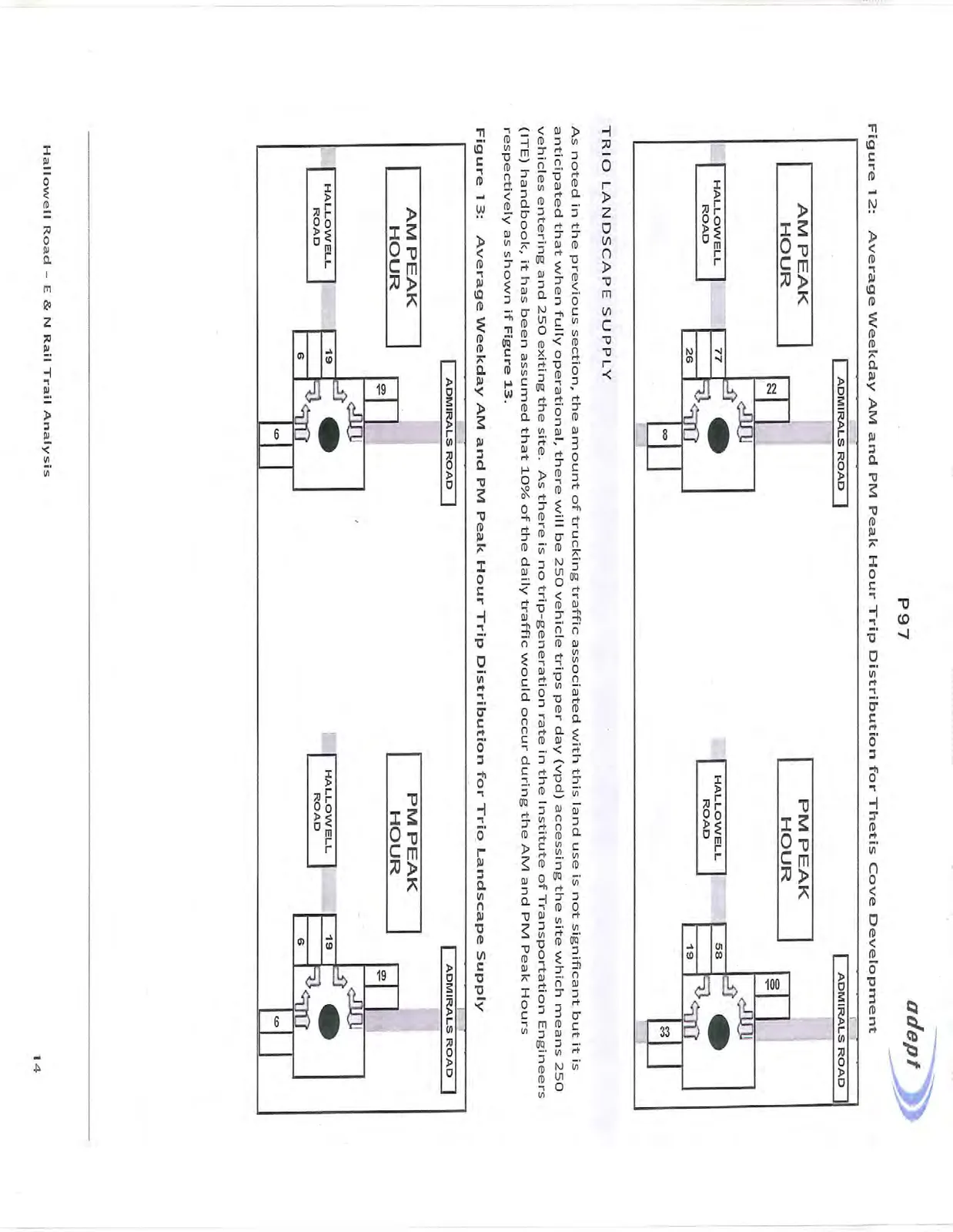
The Thetis Cove development is a Comprehensive Development Zone (CD-8) which can have a maximum of 250 residential units and the combined commercial and live/work uses cannot exceed 2,787 m² (30,000 ft²). Our current understanding is that the development concept contains 215 condominiums, 20 single family dwelling units, 15 live / work units, a restaurant and specialty retail land uses. Using the trip rates in the Institute of Transportation Engineers' Trip Generation Manual (9th Edition) results in a forecast of the site generated trips for these land uses as illustrated in Table 1. The land uses should generate 133 vph in the AM Peak Hour (30 vph entering / 103 vph exiting) and 210 vph in the PM Peak Hour (133 vph entering / 77 vph exiting. Typically the proximity to major retail and commercial businesses as well as a transit exchange would permit a reduction in these forecast trips but a conservative approach has been taken and no reductions in site-generated trips will be used.
These trips will be added to the background network as illustrated in Figure 12 and proportionally distributed on the local road network according to existing traffic patterns.
Table 1: Average Weekday AM and PM Peak Hours for Trip Generation of the Thetis Cove Development
| LAND USES | Variable | Size | AM PEAK HOUR TRAFFIC VOLUMES | PM PEAK HOUR TRAFFIC VOLUMES | ||||||||
|---|---|---|---|---|---|---|---|---|---|---|---|---|
| ITE Land Use Code | Trip Rate | % In | % Out | Trips In | Trips Out | Total 2-Way | Trip Rate | % In | % Out | Trips In | ||
| 230 | Units | 215 | 0.44 | 17% | 83% | 16 | 79 | 95 | 0.52 | 67% | 33% | 75 |
| 210 | Units | 20 | 0.75 | 25% | 75% | 4 | 11 | 15 | 1.00 | 63% | 37% | 13 |
| 210/710 | Units | 15 | 0.72 | 35% | 65% | 4 | 7 | 11 | 0.76 | 55% | 45% | 6 |
| 931 | / 1,000 ft2 | 5.5 | 0.81 | 50% | 50% | 2 | 2 | 4 | 7.49 | 67% | 33% | 28 |
| 826 | / 1,000 ft2 | 9.5 | 0.81 | 50% | 50% | 4 | 4 | 8 | 2.71 | 44% | 56% | 11 |
| TOTAL TRIPS | 30 | 103 | 133 | TOTAL TRIPS | 133 |
230 - Condominiums | 210 - SFDUs | 210 / 710 - Live / Work | 931 - Quality Restaurant | 826 - Specialty Retail
TRIO LANDSCAPE SUPPLY
As noted in the previous section, the amount of trucking traffic associated with this land use is not significant but it is anticipated that when fully operational, there will be 250 vehicle trips per day (vpd) accessing the site which means 250 vehicles entering and 250 exiting the site. As there is no trip-generation rate in the Institute of Transportation Engineers (ITE) handbook, it has been assumed that 10% of the daily traffic would occur during the AM and PM Peak Hours respectively as shown if Figure 13.
ESQUIMALT NATION TRAFFIC
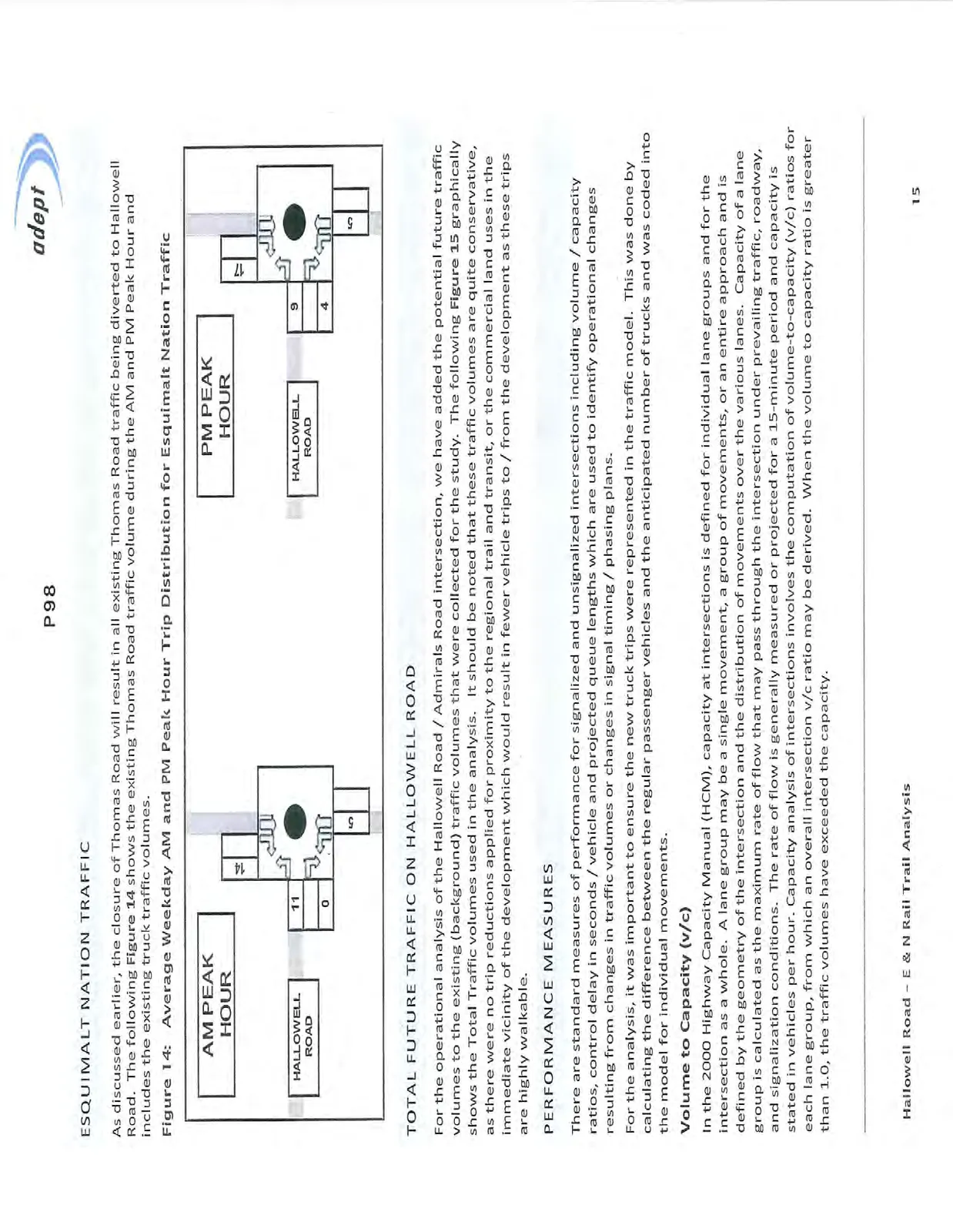
As discussed earlier, the closure of Thomas Road will result in all existing Thomas Road traffic being diverted to Hallowell Road. The following Figure 14 shows the existing Thomas Road traffic volume during the AM and PM Peak Hour and includes the existing truck traffic volumes.
TOTAL FUTURE TRAFFIC ON HALLOWELL ROAD
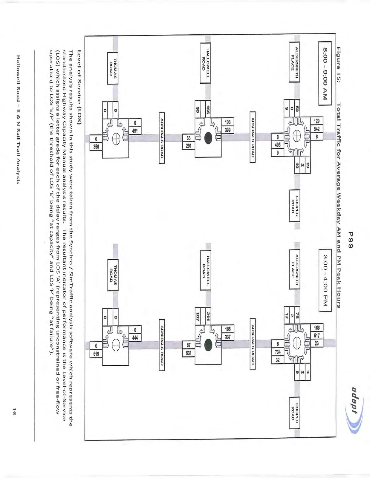
For the operational analysis of the Hallowell Road / Admirals Road intersection, we have added the potential future traffic volumes to the existing (background) traffic volumes that were collected for the study. The following Figure 15 graphically shows the Total Traffic volumes used in the analysis. It should be noted that these traffic volumes are quite conservative, as there were no trip reductions applied for proximity to the regional trail and transit, or the commercial land uses in the immediate vicinity of the development which would result in fewer vehicle trips to / from the development as these trips are highly walkable.
PERFORMANCE MEASURES
There are standard measures of performance for signalized and unsignalized intersections including volume / capacity ratios, control delay in seconds / vehicle and projected queue lengths which are used to identify operational changes resulting from changes in traffic volumes or changes in signal timing / phasing plans.
For the analysis, it was important to ensure the new truck trips were represented in the traffic model. This was done by calculating the difference between the regular passenger vehicles and the anticipated number of trucks and was coded into the model for individual movements.
Volume to Capacity (v/c)
In the 2000 Highway Capacity Manual (HCM), capacity at intersections is defined for individual lane groups and for the intersection as a whole. A lane group may be a single movement, a group of movements, or an entire approach and is defined by the geometry of the intersection and the distribution of movements over the various lanes. Capacity of a lane group is calculated as the maximum rate of flow that may pass through the intersection under prevailing traffic, roadway, and signalization conditions. The rate of flow is generally measured or projected for a 15-minute period and capacity is stated in vehicles per hour. Capacity analysis of intersections involves the computation of volume-to-capacity (v/c) ratios for each lane group, from which an overall intersection v/c ratio may be derived. When the volume to capacity ratio is greater than 1.0, the traffic volumes have exceeded the capacity.
Level of Service (LOS)
The analysis results shown in this study were taken from the Synchro / SimTraffic analysis software which represents the standardized Highway Capacity Manual analysis results. The resultant indicator of performance is the Level-of-Service (LOS) which assigns a letter grade for each of the delay ranges from LOS 'A' (representing unconstrained or free-flow operation) to LOS 'E/F' (the threshold of LOS 'E' being "at capacity" and LOS 'F' being "at failure").
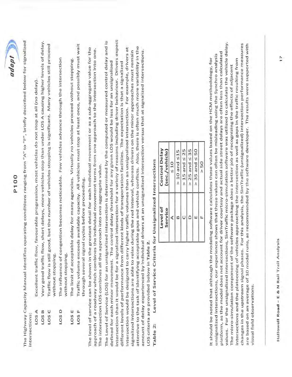
The Highway Capacity Manual identifies operating conditions ranging from “A” to “F”, briefly described below for signalized intersections:
- LOS A: Excellent traffic flow, favourable progression, most vehicles do not stop at all (no delay).
- LOS B: Very good traffic flow, short delays, more vehicles stop than under LOS A causing higher levels of delay.
- LOS C: Traffic flow is still good, but the number of vehicles stopping is significant. Many vehicles still proceed without stopping.
- LOS D: The influence of congestion becomes noticeable. Few vehicles advance through the intersection without stopping.
- LOS E: The limit of acceptable delay for many agencies. Virtually no vehicles proceed without stopping.
- LOS F: Traffic volume exceeds available capacity. All vehicles must stop at least once, and possibly must wait through several signal cycles before proceeding.
The level of service can be shown in the greatest detail for each individual movement or as a sub-aggregate value for the approach of a roadway which combines the individual movement terms from one approach to the intersection into one. The intersection LOS combines all the approach into one aggregate value.
The Level of Service (LOS) for an unsignalized intersection is determined by the computed or measured control delay and is defined for each minor movement. The control delay threshold for any given LOS would be less for an unsignalized intersection than it would be for a signalized intersection for a variety of reasons including driver behaviour. Drivers expect different levels of performance from different kinds of transportation facilities. The expectation is that a signalized intersection would be designed to carry higher traffic volumes than an unsignalized intersection. For example, drivers at signalized intersections are able to relax during the red interval, whereas drivers on the minor approaches must remain attentive to the task of identifying acceptable gaps and vehicle conflicts. Also, there is often much more variability in the amount of delay experienced by individual drivers at an unsignalized intersection versus that at signalized intersections. LOS criteria are provided below in Table 2.
Table 2: Level of Service Criteria for Unsignalized Intersections
| Level of Service | Control Delay (sec./vehicle) |
|---|---|
| A | ≤ 10 |
| B | > 10 and ≤ 15 |
| C | > 15 and ≤ 25 |
| D | > 25 and ≤ 35 |
| E | > 35 and ≤ 50 |
| F | > 50 |
It should be noted that although the modeling software calculates these values based on the HCM methodology, for unsignalized intersections, our experience shows that these values can often be misleading using the Synchro analysis platform, as the model does not account for driver courtesy and actual side street delays are often less than calculated values. For the unsignalized intersections, SimTraffic micro-simulation software was utilized to calculate the vehicle delay. The micro-simulation component of the software package does a better job of recognizing the effects of adjacent intersections and the platooning of vehicles approaching the intersection as well as gaps in the traffic resulting from changes in the upstream signal phases. For this analysis, the SimTraffic (unsignalized) intersection performance measures are based on an average of 10 model runs, as recommended by the software developer. The results were supported with visual field observations.
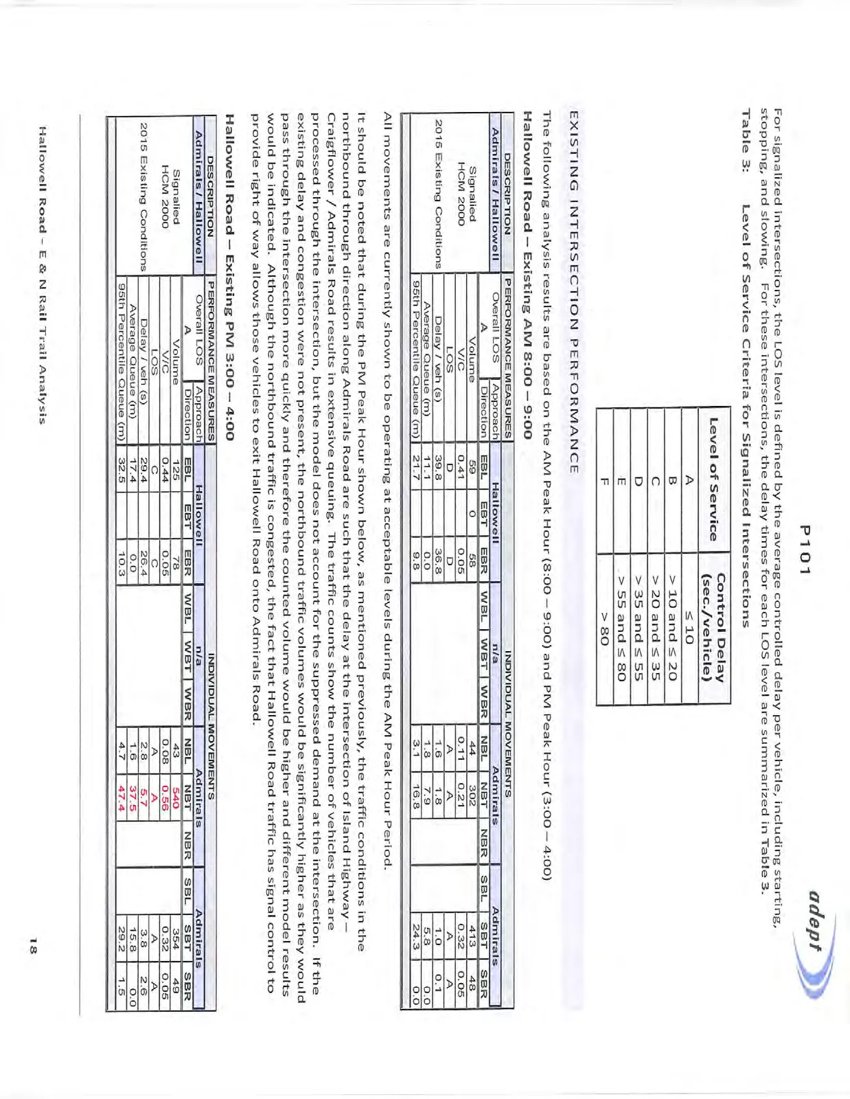
For signalized intersections, the LOS level is defined by the average controlled delay per vehicle, including starting, stopping, and slowing. For these intersections, the delay times for each LOS level are summarized in Table 3.
Table 3: Level of Service Criteria for Signalized Intersections
| Level of Service | Control Delay (sec./vehicle) |
|---|---|
| A | ≤ 10 |
| B | > 10 and ≤ 20 |
| C | > 20 and ≤ 35 |
| D | > 35 and ≤ 55 |
| E | > 55 and ≤ 80 |
| F | > 80 |
EXISTING INTERSECTION PERFORMANCE
The following analysis results are based on the AM Peak Hour (8:00 – 9:00) and PM Peak Hour (3:00 – 4:00)
Hallowell Road – Existing AM 8:00 – 9:00
| DESCRIPTION | PERFORMANCE MEASURES | INDIVIDUAL MOVEMENTS | ||||||||
|---|---|---|---|---|---|---|---|---|---|---|
| Admirals / Hallowell | Overall LOS | Approach | Hallowell | n/a | Admirals | Admirals | ||||
| A | Direction | EBL | EBT | EBR | WBL | WBT | WBR | NBL | NBT | |
| Signalled HCM 2000 | Volume | 59 | 0 | 58 | 44 | 302 | ||||
| V/C | 0.41 | 0.05 | 0.11 | 0.21 | ||||||
| LOS | D | D | A | A | ||||||
| 2015 Existing Conditions | Delay / veh (s) | 39.8 | 36.8 | 1.6 | 1.8 | |||||
| Average Queue (m) | 11.1 | 0.0 | 1.8 | 7.9 | ||||||
| 95th Percentile Queue (m) | 21.7 | 9.8 | 3.1 | 16.8 |
All movements are currently shown to be operating at acceptable levels during the AM Peak Hour Period.
It should be noted that during the PM Peak Hour shown below, as mentioned previously, the traffic conditions in the northbound through direction along Admirals Road are such that the delay at the intersection of Island Highway – Craigflower / Admirals Road results in extensive queuing. The traffic counts show the number of vehicles that are processed through the intersection, but the model does not account for the suppressed demand at the intersection. If the existing delay and congestion were not present, the northbound traffic volumes would be significantly higher as they would pass through the intersection more quickly and therefore the counted volume would be higher and different model results would be indicated. Although the northbound traffic is congested, the fact that Hallowell Road traffic has signal control to provide right of way allows those vehicles to exit Hallowell Road onto Admirals Road.
Hallowell Road – Existing PM 3:00 – 4:00
| DESCRIPTION | PERFORMANCE MEASURES | INDIVIDUAL MOVEMENTS | ||||||||
|---|---|---|---|---|---|---|---|---|---|---|
| Admirals / Hallowell | Overall LOS | Approach | Hallowell | n/a | Admirals | Admirals | ||||
| A | Direction | EBL | EBT | EBR | WBL | WBT | WBR | NBL | NBT | |
| Signalled HCM 2000 | Volume | 125 | 78 | 43 | 540 | |||||
| V/C | 0.44 | 0.05 | 0.08 | 0.56 | ||||||
| LOS | C | C | A | A | ||||||
| 2015 Existing Conditions | Delay / veh (s) | 29.4 | 26.4 | 2.8 | 5.7 | |||||
| Average Queue (m) | 17.4 | 0.0 | 1.6 | 37.5 | ||||||
| 95th Percentile Queue (m) | 32.5 | 10.3 | 4.7 | 47.4 |
Aldersmith Place – AM 8:00 – 9:00 Future Total
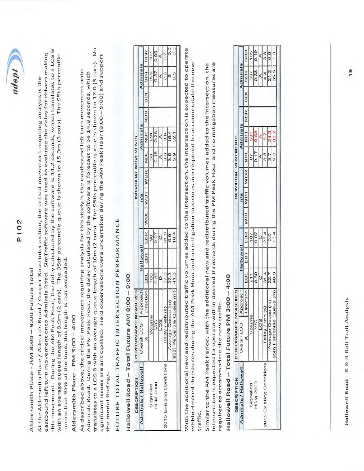
At the Aldersmith Place / Admirals Road / Cooper Road intersection, the critical movement requiring analysis is the eastbound left turn movement onto Admirals Road. SimTraffic software was used to evaluate the delay for drivers making this movement. During the AM Peak Hour, the delay calculated by the software is 14.2 seconds, which translates to a LOS B with an average queue length of 8.9m (2 cars). The 95th percentile queue is shown to 15.9m (3 cars). The 95th percentile means that 95% of the time, this length is not exceeded.
Aldersmith Place – PM 3:00 – 4:00
As described above, the critical movement requiring analysis for this study is the eastbound left turn movement onto Admirals Road. During the PM Peak Hour, the delay calculated by the software is forecast to be 14.8 seconds, which translates to a LOS B with an average queue length of 10m (2 cars). The 95th percentile queue is shown to 17.0 (3 cars). No significant issues are anticipated. Field observations were undertaken during the AM Peak Hour (8:00 – 9:00) and support the model findings.
FUTURE TOTAL TRAFFIC INTERSECTION PERFORMANCE
Hallowell Road – Total Future AM 8:00 – 9:00
| DESCRIPTION | PERFORMANCE MEASURES | INDIVIDUAL MOVEMENTS | ||||||||
|---|---|---|---|---|---|---|---|---|---|---|
| Admirals / Hallowell | Overall LOS | Approach | Hallowell | n/a | Admirals | Admirals | ||||
| A | Direction | EBL | EBT | EBR | WBL | WBT | WBR | NBL | NBT | |
| Signalled HCM 2000 | Volume | 166 | 90 | 63 | 291 | |||||
| V/C | 0.59 | 0.07 | 0.15 | 0.28 | ||||||
| LOS | D | C | A | A | ||||||
| 2015 Existing Conditions | Delay / veh (s) | 37.8 | 31.6 | 3.3 | 3.6 | |||||
| Average Queue (m) | 27.3 | 0.0 | 3.5 | 15.4 | ||||||
| 95th Percentile Queue (m) | 41.6 | 10.4 | 5.9 | 32.1 |
With the additional new and redistributed traffic volumes added to the intersection, the intersection is expected to operate within desired thresholds during the AM Peak Hour and no mitigation measures are required to accommodate the new traffic.
Similar to the AM Peak Period, with the additional new and redistributed traffic volumes added to the intersection, the intersection is expected to operate within desired thresholds during the PM Peak Hour and no mitigation measures are required to accommodate the new traffic.
Hallowell Road – Total Future PM 3:00 – 4:00
| DESCRIPTION | PERFORMANCE MEASURES | INDIVIDUAL MOVEMENTS | ||||||||
|---|---|---|---|---|---|---|---|---|---|---|
| Admirals / Hallowell | Overall LOS | Approach | Hallowell | n/a | Admirals | Admirals | ||||
| A | Direction | EBL | EBT | EBR | WBL | WBT | WBR | NBL | NBT | |
| Signalled HCM 2000 | Volume | 211 | 107 | 87 | 531 | |||||
| V/C | 0.60 | 0.07 | 0.17 | 0.58 | ||||||
| LOS | C | C | A | A | ||||||
| 2015 Existing Conditions | Delay / veh (s) | 31.4 | 25.4 | 3.8 | 5.7 | |||||
| Average Queue (m) | 22.7 | 0.0 | 3.7 | 24.3 | ||||||
| 95th Percentile Queue (m) | 40.3 | 10.4 | 9.3 | 33.7 |
MODAL SHIFT TO E&N RAIL TRAIL
Earlier in the report, the number of cyclists recorded on Hallowell and Admirals Road were briefly discussed. A total of 603 cyclists were recorded travelling northbound and southbound on Admirals Road between 6:00 AM and 6:00PM with peak hours of cyclists occurring at 6:45AM – 7:45AM and 4:30PM – 5:30PM with 159 and 182 cyclists respectively. As expected, there is a significant directional bias to the trips with 94% of the trips being southbound in the AM Peak Hour and 93% of the trips being northbound in the PM Peak Hour.
What is also significant about these figures is the modal shift that it represents. Based on previous peak commuter period occupancy counts along Island Highway in View Royal, private vehicle occupancy rate was determined at approximately 1.2 persons / vehicle and as such the current cycling volumes are the equivalent to 133 and 151 vehicles in the AM and PM Peak Hours respectively.
The CRD has long stressed the benefits of modal shifts and participation in active transportation which are integral components to lowering green house gas emissions and embarking on a more sustainable approach for society as a whole. In this instance there are also significant benefits to the employment base of DND and CFB Esquimalt and the Esquimalt Graving Dock in participating and encouraging these activities.
As an example, a shift of 600 vehicle drivers and passengers to cycling is the equivalent of 500 less vehicles on the road. While the amount of existing congestion on Admirals Road would not be eliminated it could dramatically reduce delays that drivers are currently experiencing at intersections which are operating at Level of Service E and F during the PM Peak period.
CONCLUSION
With respect to traffic operations:
- The amount of new truck traffic anticipated on Hallowell Road, west of the Thrifty Foods / Trio Landscape Supply driveways will consist of the existing truck traffic currently using Thomas Road which is not anticipated to be significant;
- The existing Hallowell Road corridor is currently shared with vehicle traffic and cyclists. The new traffic generated by the Trio Ready-Mix commercial operation and the anticipated Thetis Cove development traffic will create additional safety risk for cyclists. The construction of the proposed E&N Trail parallel to Hallowell Road will separate pedestrians and cyclists from the roadway and reduce risk to these vulnerable road users;
- Along Admirals Road, significant delay and congestion are currently present, particularly during the PM Peak Period due mainly to the significant traffic volumes associated with the commuter traffic from CFB Esquimalt and Esquimalt Graving Dock in Esquimalt. This condition is attributed to a high percentage of Single Occupant Vehicles competing for green signal time at the signalized intersection of Admirals Road / Island Highway – Craigflower Road. Similar queuing issues are present along the Craigflower Road approach to Admirals Road as commuters from areas to the east, including Downtown Victoria, travel to destinations in the west with the Westshore communities being a primary destination.
- A notable amount of cyclist activity was recorded along Hallowell Road and Admirals Road corresponding with the peak DND – Shipyards commuter traffic periods. It is anticipated that once the E&N Trail is complete, there could be significant growth in cyclist and pedestrian traffic along the corridor. The existing traffic conditions along Admirals Road could improve somewhat if significant mode splits result during commuter traffic periods.
- With the additional development-related traffic anticipated at the Hallowell Road and Aldersmith Place intersections with Admirals Road as a result of the network modifications, the analysis indicates that the operational performance indicators at the Admirals Road intersections are expected to within acceptable thresholds and no mitigation measures are required.
RECOMMENDATIONS
As a result of the traffic analysis contained in this study, the following recommendations are outlined below:
- Relocate the existing Admirals Road crosswalk at Hallowell Road to the south leg of the intersection to improve pedestrian safety and reduce left turn delays from Hallowell Road onto Admirals Road;
- Consider adding dedicated bike lanes on both sides of Admirals Road between Craigflower Road - Island Highway to Hallowell Road;
- As per previous reports, consideration should be given for the installation of a traffic signal at the intersection of Aldersmith Place / Admirals Road to improve side street egress and pedestrian crossing safety. MoTI may wish to undertake a formal warrant analysis if this has not been done to date;
- At the new Trio Landscape Supply driveway, implement crossing measures to ensure that all vehicle operators know that trail traffic is present and extreme caution should be used. Green conflict paint along the trail crossing and appropriate signage to caution exiting traffic of the trail is recommended. Additionally, clear sight lines will need to be ensured at the driveway access for trail users as well as vehicles entering or exiting the site;
- That the CRD continue efforts to develop the E&N Trail segment along Hallowell Road and Admirals Road;
- That the CRD develop a program in conjunction with DND and other major employers in the same area to encourage alternate mode travel;
- That the CRD work with the Town of View Royal and other Westshore municipalities to explore additional Park & Ride locations to further encourage trip chaining and a shift away from the single occupant vehicle for commuter cyclists and pedestrians.
With respect to the new heavy truck traffic anticipated along Hallowell Road, the following recommendations are as follows:
- A staging area on or directly adjacent the Trio Landscape and Ready-Mix sites will need to be established to ensure that trucks do not park on Hallowell Road while waiting to deliver or receive materials;
- Restrict engine compression brake usage on municipal roads;
- Conduct regular vehicle safety inspections;
- An inventory of existing road surface condition along Hallowell Road should be undertaken to ensure roadways are restored to original condition by Ralmax as required;
- The CRD Code of Practice for “Construction and Development Activities” could be used by Ralmax to minimize dust and mud impacts on the local roads;
- That Trio Ready-Mix and Landscape Supply be responsible for ongoing maintenance of the street and trail to ensure immediate response in the event of debris tracking; and,
- That the commercial sites be designed to minimize noise impacts to the local residential neighbourhood.
Document Images
(10)