Appendix
Appendix: Master Transportation Plan 2008 Design Concept Map
June 23, 2015Page 1091 section
Aerial map overlay showing future signalization and lane improvements for the Admirals Road corridor.
Exhibit A6Bunt & Associates
View Royal Transportation Plan: Admirals Road South of Island Highway
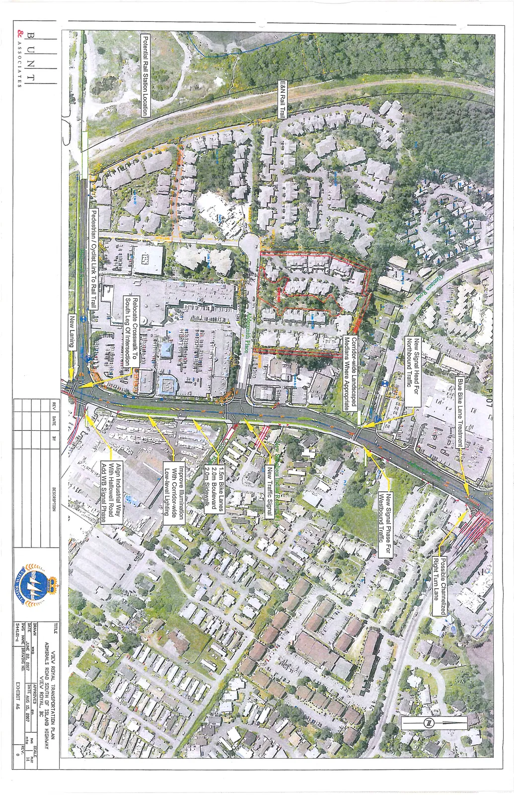
Map Features and Annotations
- Blue Bike Lane Treatment: Located at the northern intersection with Island Highway.
- Possible Channelized Right Turn Lane: At the intersection with Island Highway.
- New Signal Head For Northbound Traffic: At the intersection of Admirals Road and Glentana Road.
- New Signal Phase For Westbound Traffic: At the intersection of Admirals Road and Glentana Road.
- Corridor-wide Landscaped Medians Where Appropriate: Along the center of Admirals Road.
- New Traffic Signal: At the intersection of Admirals Road and Aldersmith Place.
- 1.5m Bike Lanes, 2.0m Boulevard, 2.0m Sidewalk: Cross-section specifications for the Admirals Road corridor.
- Improve Illumination With Corridor-wide Low-level Lighting: Along the Admirals Road corridor.
- Align Industrial Way With Hallowell Road, Add WB Signal Phase: Realignment and signalization at the southern end of the corridor.
- Relocate Crosswalk To South Leg Of Intersection: At the Admirals Road and Aldersmith Place intersection.
- Pedestrian / Cyclist Link To Rail Trail: Connecting the E&N Rail Trail to the southern intersection area.
- New Laning: Proposed at the intersection of Admirals Road and Industrial Way/Hallowell Road.
- Potential Rail Station Location: Identified along the E&N Rail Trail.
- E&N Rail Trail: Running parallel to Admirals Road on the western side.
- Glentana Road: Intersecting Admirals Road from the east.
- Aldersmith Place: Intersecting Admirals Road from the west.
Project Information
| REV | DATE | BY | DESCRIPTION |
|---|---|---|---|
| Field | Detail |
|---|---|
| TITLE | VIEW ROYAL TRANSPORTATION PLAN, ADMIRALS ROAD SOUTH OF ISLAND HIGHWAY, VIEW ROYAL, BC |
| DRAWN | wwg |
| DATE | JUNE 22, 2007 |
| APPROVED | en |
| DATE | AUG 15, 2007 |
| DWG NAME / DRAWING NO. | 5441.01-c / EXHIBIT A6 |
| SCALE | nts |
| PLOT | 1:1 |
| REV | 0 |
Page 109
Extracted from: 2015 06 23 Council Agenda