Staff Report: Environmental Development Permit No. 2011/16 – 2101 Munn Road
Report recommending approval of a development permit for an accessory building for a proposed telecommunications tower with environmental conditions.
PLANNING & DEVELOPMENT REPORT
TO: Mayor & Council DATE: May 9, 2012 FROM: Jeff Chow, Senior Planner MEETING: May 15, 2012 FILE NO: 3060-20-2011/16
ENVIRONMENTAL DEVELOPMENT PERMIT NO. 2011/16
2101 MUNN ROAD
RECOMMENDATION:
THAT Development Permit No. 2011/16 be approved to permit construction of an accessory building for a proposed telecommunications tower at 2101 Munn Road as per the plans attached to the May 9, 2012 report from the Senior Planner;
AND THAT Committee of the Whole recommend to Council that Development Permit 2011/16 include the following conditions:
- Qualified Environmental Professional (QEP) to be on-site during disturbances associated with the tower construction and site laydown;
- If removal of the six Garry oaks is necessary, replacement Garry oaks are to be replanted within 100 m of the site at a ratio of no less than 3:1;
- Three nesting boxes (size and location to be determined by QEP) are to be provided to mitigate tree loss in the area required for the tower and site laydown;
- Any disturbed areas are to be replanted with native plants under the supervision of the QEP; and
- Financial security to ensure that development permit requirements are met.
CHIEF ADMINISTRATIVE OFFICER'S COMMENTS:
I concur with the recommendation.
DIRECTOR OF DEVELOPMENT SERVICES' COMMENTS:
I concur with the recommendation.
PURPOSE OF REPORT
The applicant is seeking Council's approval of an Environmental Development Permit to construct a wireless telecommunications facility. The consultation process required by Industry Canada for the proposed telecommunications tower will be presented in a separate report.
SUMMARY
The application is for an Environmental Development Permit to construct a wireless telecommunications facility within the Sensitive Terrestrial Ecosystems Development Permit Area. The proposal is in accordance with the development permit area guidelines. A study by Cascadia Biological Services found that within 50 m of the facility site there are no riparian areas, no red or blue listed plant species, and no stick-nests or other environmentally significant attributes as defined by the BC Conservation Data Centre. It is recommended that the application be approved with conditions as recommended in the Registered Professional Biologists Report.
BACKGROUND
The 32 ha parcel is located north of Thetis Regional Park on the municipal boundary shared with the District of Highlands. It is one of one of several owned by BC Hydro that buffer a power station. The facility would be sited in the northwest corner of the parcel directly south of a major overhead power line transmission corridor.
The application is for the construction of an antenna tower, an accessory building to store cellular equipment, and a backup generator as shown in Figure 1. It should be noted that telecommunication towers are regulated by Industry Canada and the applicant has undertaken a public consultation process in accordance with Industry Canada guidelines and will conclude it with the Town of View Royal as the local land use authority.
The parcel is subject to the Sensitive Terrestrial Ecosystems Development Permit Area for the protection of the natural environment and protection of development from hazardous conditions. A study by Cascadia Biological Services found that within a 50 m of the facility site, there are no riparian areas, no red or blue listed plant species, and no stick nests or other environmentally significant attributes as defined by the BC Conservation Data Centre.
UPDATED INFORMATION
Following the January 10, 2012 Committee of the Whole meeting and the subsequent public consultation process, the plans have been updated as follows:
1. Antenna Height
The antenna height has been reduced by 5 from 60 m to 55 m minimize visual impacts while still preserving the tower’s functions. This has no implications for the development permit.
2. Site Layout
The tower was intended to be located inside a square footprint with a chain link fence. The north corner of the compound has been shifted back (See Figure 1) to make the area of the compound smaller and to reduce any potential impact on the root zones of adjacent trees to be retained, such as the Garry oak and Arbutus tree cluster to the north.
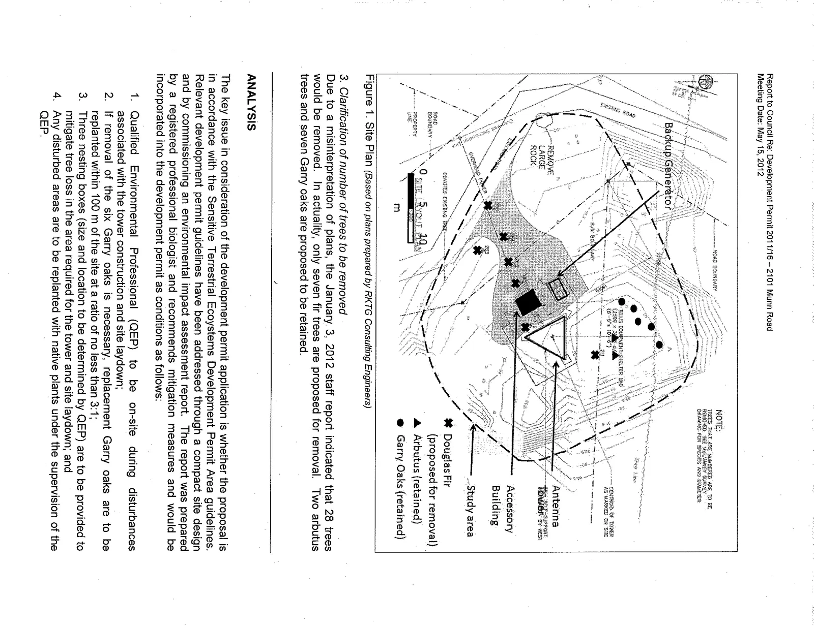
Figure 1. Site Plan (Based on plans prepared by RKTG Consulting Engineers)
3. Clarification of number of trees to be removed
Due to a misinterpretation of plans, the January 3, 2012 staff report indicated that 28 trees would be removed. In actuality, only seven fir trees are proposed for removal. Two arbutus trees and seven Garry oaks are proposed to be retained.
ANALYSIS
The key issue in consideration of the development permit application is whether the proposal is in accordance with the Sensitive Terrestrial Ecosystems Development Permit Area guidelines. Relevant development permit guidelines have been addressed through a compact site design and by commissioning an environmental impact assessment report. The report was prepared by a registered professional biologist and recommends mitigation measures and would be incorporated into the development permit as conditions as follows:
- Qualified Environmental Professional (QEP) to be on-site during disturbances associated with the tower construction and site laydown;
- If removal of the six Garry oaks is necessary, replacement Garry oaks are to be replanted within 100 m of the site at a ratio of no less than 3:1;
- Three nesting boxes (size and location to be determined by QEP) are to be provided to mitigate tree loss in the area required for the tower and site laydown;
- Any disturbed areas are to be replanted with native plants under the supervision of the QEP.
The permit would include financial security to ensure that the terms of the development permit are met. It is also recommended that this application be considered at a future Council meeting in conjunction with the Industry Canada land use consultation process for the proposed telecommunications tower that the applicant is currently undertaking.
RECOMMENDATION
THAT Committee of the Whole recommend to Council that Development Permit No. 2011/16 be approved to permit construction of an accessory building for a proposed telecommunications tower at 2101 Munn Road as per the plans attached to the January 3, 2012 staff report;
AND THAT Committee of the Whole recommend to Council that Development Permit 2011/16 include the following conditions:
- Qualified Environmental Professional (QEP) to be on-site during disturbances associated with the tower construction and site laydown;
- If removal of the six Garry oaks is necessary, replacement Garry oaks are to be replanted within 100 m of the site at a ratio of no less than 3:1;
- Three nesting boxes (size and location to be determined by QEP) are to be provided to mitigate tree loss in the area required for the tower and site laydown;
- Any disturbed areas are to be replanted with native plants under the supervision of the QEP; and
- Financial security to ensure that development permit requirements are met.
SUBMITTED BY: Jeff Chow, Senior Planner
REVIEWED BY: Lindsay Chase, Director of Development Services
ATTACHMENTS
- CRD Context Plan
- Location plan
- Letter to L. Chase from Chad Martatt (Dec. 6, 2011, 6 pages)
- Environmental Assessment - Cascadia Biological Services (Nov. 27, 2011, 6 pages)
- Key Plan - B19-3027-100 - Robertson Kolbeins Teevan G Associates Ltd. (May 4, 2012)
- Site Plan - B19-3027-101 - RKTG Associates Ltd. (May 4, 2012)
- Compound Layout Plan - B19-3027-102.1 - RKTG Associates Ltd. (May 4, 2012)
- Section Through Site (South East Elev.) - B19-3027-103 - RKTG Associates Ltd. (May 4, 2012)
- Antenna Orientation Plan - B19-3027-104 - RKTG Associates Ltd. (May 4, 2012)
- Antenna Orientation Plan - B19-3027-105 - RKTG Associates Ltd. (May 4, 2012)
- Tree Survey - McIlvaney Riley Land Surveying Inc. (August 2011)
Document Images
(3)