Appendix
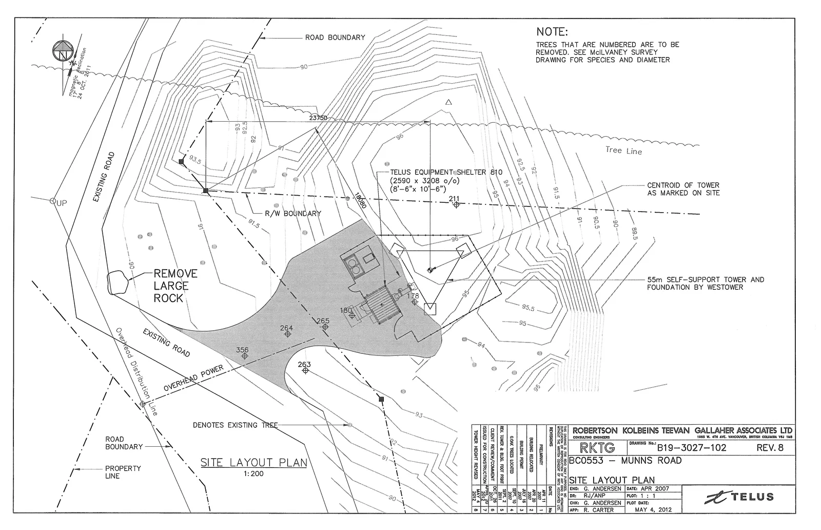
Site Layout Plan - Drawing B19-3027-102
May 15, 2012Page 861 section
Technical layout showing the precise location of the tower foundation and equipment shelter.
1:200 scale
SITE LAYOUT PLAN - MUNNS ROAD
General Notes
- TREES THAT ARE NUMBERED ARE TO BE REMOVED. SEE McILVANEY SURVEY DRAWING FOR SPECIES AND DIAMETER
Site Plan Details
- Scale: 1:200
- Project Name: RKTG BC0553 — MUNNS ROAD
- Proposed Infrastructure:
- TELUS EQUIPMENT SHELTER 810 (2590 x 3208 o/o) (8'-6" x 10'-6")
- 55m SELF-SUPPORT TOWER AND FOUNDATION BY WESTOWER
- CENTROID OF TOWER AS MARKED ON SITE
- Site Features and Markers:
- Road Boundary
- Property Line
- R/W Boundary
- Existing Road
- Overhead Power / Overhead Distribution Line
- Tree Line
- Denotes existing tree (marked with numbered symbols like 356, 264, 263, 265, 180, 178, 211)
- Action: REMOVE LARGE ROCK
Revision History
| No. | Revision | Date |
|---|---|---|
| 1 | PRELIMINARY | APR 11, 2007 |
| 2 | BUILDING RELOCATED | JUNE 20, 2007 |
| 3 | BUILDING PERMIT | JULY 18, 2007 |
| 4 | COORD. TREES LOCATED | SEPT 10, 2007 |
| 5 | REV. TOWER & BLDG. FOOT PRINT | SEPT 21, 2007 |
| 6 | CLIENT REVIEW/COMMENT | OCT 26, 2007 |
| 7 | ISSUED FOR CONSTRUCTION | APR 3, 2012 |
| 8 | TOWER HEIGHT REVISED | MAY 4, 2012 |
Project Administration
- Consulting Engineers: ROBERTSON KOLBEINS TEEVAN GALLAHER ASSOCIATES LTD.
- Drawing No.: B19-3027-102
- Revision: 8
- Date: APR 2007
- Plot Date: MAY 4, 2012
- Personnel:
- ENG: G. ANDERSEN
- DR: RJ/ANP
- CHK: G. ANDERSEN
- APP: R. CARTER
- PLOT: 1:1
Page 86
Extracted from: 2012 05 15 Council Agenda