STAFF REPORT: OFFICIAL COMMUNITY PLAN AND REZONING APPLICATION “EAGLE CREEK VILLAGE”
Report recommending first and second reading for OCP and rezoning bylaws for the Eagle Creek Village mixed-use development.
TOWN OF VIEW ROYAL
Planning & Development Report
TO: Mayor and Council
DATE: October 31, 2012
FROM: Jeff Chow, Senior Planner
MEETING DATE: November 6, 2012
FILE NO: OCP 3440-20-2012-01, Rezoning 3360-20-2012-01
OFFICIAL COMMUNITY PLAN AND REZONING APPLICATION
“Eagle Creek Village”
21, 23, 29 Helmcken Road; 1650 Little Road; and part of 1 Hospital Way
RECOMMENDATION:
THAT Official Community Plan Amendment Bylaw No. 848, 2012 be given first and second reading;
AND THAT Land Use Amendment Bylaw No. 849, 2012 be given first and second reading;
AND THAT a Public Hearing be scheduled for November 20, 2012 for the bylaws;
AND THAT coincident with final reading of Land Use Bylaw Amendment Bylaw No. 849, 2012, a covenant be registered to secure the following: a. Dedication of the 1.58 ha park as part of Phase 2 of the project; b. Construction trails in or near the park as part of Phase 2 of the project; c. A statutory right-of-way for public and access to the proposed park as part of Phase 2 of the project; and d. Requirement that Building 2 to be constructed as a one storey building
AND FURTHER THAT the $1 million community amenity contribution offered by the applicant be provided coincident with final reading of Land Use Bylaw Amendment Bylaw No. 849, 2012.
CHIEF ADMINISTRATIVE OFFICER’S COMMENTS: I concur with the recommendations.
DIRECTOR OF DEVELOPMENT SERVICES’ COMMENTS: I concur with the recommendations.
PURPOSE OF REPORT
- To introduce the Official Community Plan and Land Use Bylaw amendment bylaws for first and second reading
- To set a public hearing date
- To secure community amenity contributions and other commitments
SUMMARY
The proposal is in accordance with the intent of the Official Community Plan. The Official Community Plan amendment and rezoning bylaws have been prepared and are recommended for first and second reading. It is recommended that Council set a public hearing for November 20, 2012, subject to confirmation of a signed covenant.
The conceptual site plan being developed for the development permit stage has continued to evolve. The building height of one building has been lowered to reduce impacts on adjacent townhouses. The Watkiss Way frontage and driveway has been modified to improve pedestrian access.
A more comprehensive traffic impact assessment has been submitted. A traffic control is required at the proposed Watkiss way entrance the site and the decision on whether it should be a roundabout or conventional traffic signal can be made at the development permit stage.
A covenant is proposed to secure commitments associated with the rezoning, such as park dedication, park trail construction, and a one-storey height restriction for Building 2, which is adjacent to existing townhouse residences. The applicant may need to petition for a local area service bylaw to provide storm water management offsite. The budget implications for taking on the additional park land are minor given the additional property tax revenue that would result from the land lift. The concept of constructing part of the proposed trail in the Little Road road allowance as a multi-use trail connector towards Burnside Road West appears to be feasible because there is enough road allowance within the municipal boundary and the initial reaction from the adjoining District of Saanich is supportive.
BACKGROUND
The 5.8 ha site is located at the northeast corner of the Helmcken Road and Watkiss Way intersection and is comprised of five parcels (see Attachment 1):
- A parcel zoned R-1 (One Family Residential - Large Lot) and P-1 (Community Institutional) at 21 Helmcken Road with a single family dwelling and three modular buildings operating as a day-care centre.
- Three A-1 (Rural) zoned parcels at 23 Helmcken Road, 29 Helmcken Road, and 1650 Little Road that are part of a rural property with a farm house remaining on the site. The parcels were excluded from the Agricultural Land Reserve in 2002 and have been the subject of several development proposals dating back to 1997 that were never finished.
- A 7,770 m² P-1 (Community Institutional) zoned undeveloped piece of land known as “VGH Triangle” that is part of Victoria General Hospital but separated by Watkiss Way.
The applicant held two public information meetings to present the proposal and receive public input. The first meeting was advertised in the Goldstream Gazette and Times Colonist and was held April 28, 2012 with 14 people in attendance. A second meeting was held August 9, 2012 following advertisements in the Goldstream Gazette and Times Colonist and a Canada Post flyer drop to 768 nearby residences. 62 people attended.
The Official Community Plan and rezoning applications were introduced at the June 7, 2012 Committee of the Whole meeting. The Joint Advisory Committee then reviewed the proposal on July 24, 2012 and recommended support of the proposed land use and density (motion JOIN 01-12). Since the September 11, 2012 update report to Committee of the Whole, the site concept (Attachment 3) has been modified as follows:
- 4.22 ha development site with 1.58 ha of park (3.8 acres) – previously a 4.6 ha development site with 1.2 ha of dedicated park land. The park boundary was modified to accommodate a revised driveway access from Watkiss Way and to allow a more continuous sidewalk from Watkiss Way.
- Building 2 is proposed to be reduced in height to so that the buildings facing the adjacent townhouses at Helmcken Road would be mostly one storey.
- The grocery has been detached from the office building to provide an additional pedestrian access from the transit stop on Watkiss Way and to break up the massing of the building.
- The office building closest to the Helmcken Road and Watkiss Way intersection is now proposed to be located close to the exterior lot lines to improve the interior layout and to address the street better.
PROPOSAL
The applicant has applied to amend the Official Community Plan and to rezone the site. The Official Community Plan amendment proposal is to amend the land use designations from Community Facility and Neighbourhood Mixed-Use and to Park, Open Space, Recreation and Neighbourhood Mixed-Use as shown in Figure 1. A corresponding amendment to the boundaries of the Neighbourhood Mixed-Use Development Permit Area (Schedule P of the Official Community Plan) to match the Neighbourhood Mixed-Use land use designation will also be required.
The rezoning application is to rezone 4.22 ha of the site (See Figure 2) to a new Eagle Creek Village Comprehensive Development Zone: CD-20 to permit a commercial/residential mixed use development and to rezone 1.58 ha at the north end to Park and Recreation Use: P-3 as shown in Figure 2. Due to the location adjacent to a Controlled Access Highway, the Transportation Act requires Ministry of Transportation and Infrastructure approval prior to fourth reading.
The applicant’s intent is to construct a 10,390 m² shopping centre, 6,468 m² of medical and professional office space, and 138 apartment residential units. Project data is summarized on the site plan in Attachment 2. Details of the building design and conceptual layout will be required in a future development permit application.
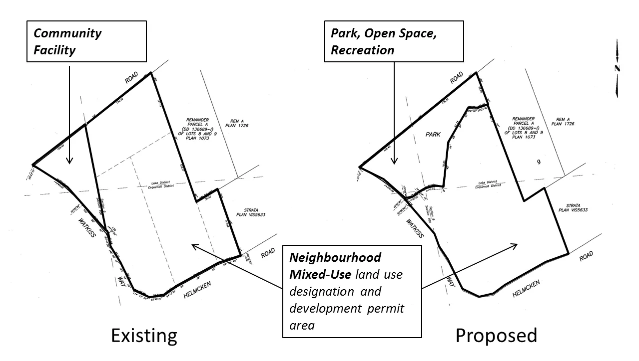
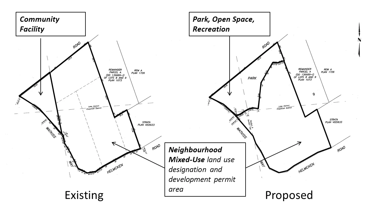
Community amenity contributions offered by the applicant were reviewed and accepted at the September 11, 2012 Community of the Whole meeting. They include the following: a. Community amenity contribution of $1,000,000. The cash contribution would be provided coincident with fourth reading of the rezoning bylaw. b. Dedication of 1.58 ha of park land in association with Phase 2 of the project c. Construction of trails and bridges within the park and/or a multiuse trail in the Little Road road allowance in association with Phase 2 of the project.
The applicant proposes to construct the project in two phases. Setback variances to the phase lines may be required as part of the development permit.
DISCUSSION
The key issues relating to this proposal include the following:
- Policy implications
- Principles of the proposed new zone
- Mitigation of potential traffic and transportation impacts
- Servicing
- Budget implications
- Commitments to be secured in association with the rezoning
1. Policy Implications
The site is located within the Urban Growth Boundary. The Helmcken Road frontage is within the Northern Gateway Community Corridor (Policy LU11.1), which is an OCP Change Area supporting mixed use and densities that benefit from the Corridor’s proximity to the Victoria General Hospital and the planned regional rapid transit stop. The proposal is be in accordance with the policy and addresses it as follows:
- Apartment use is proposed as part of the project
- Ground level commercial uses are proposed
- Proposed commercial uses are those acceptable to the policy, including medical offices and related facilities, small format retail, restaurants, food stores and rental accommodation
- Big box retail and wholesale outlets are not proposed
- Access and circulation are key considerations
- Sidewalk and bicycle lane frontage improvements would enhance connections to the planned hospital rapid transit stop and Galloping Goose Regional Trail, Trans-Canada Highway and established residential area east of Helmcken Road
Opportunities to consider quality of the built environment and for wayfinding and placemaking elements that reinforce the Hospital Neighbourhood as the northern gateway to View Royal will be considered at the development permit stage.
The bulk of the site is within the Neighbourhood Mixed-Use Development Permit Area. An amendment to the development permit area boundaries is recommended to accommodate the development. The Hospital Triangle and 1650 Little Road are within the Terrestrial Sensitive Ecosystem Development Permit Area and no changes to the boundary are necessary.
2. New Comprehensive Development – 20 (Eagle Creek Village): CD-20 Zone
A new Comprehensive Development – 20 (Eagle Creek Village): CD-20 is proposed to accommodate the development by allowing shopping centre and office uses that would be compatible with on-site residential uses. Specific considerations for the zone include:
- Commercial uses generally based on Village Commercial (C-1) zone, Village Service Commercial (C-1A) zone, and partly on Business Park Commercial (C-7) zones.
- Capping floor space to discourage big box retail use
- Proving for a range of uses suitable for a neighbourhood centre
- Prohibiting uses such as drive-throughs that are not appropriate in mixed commercial-residential developments.
Staff also propose a modification to the definition of Medical Clinic to widen the scope of the land use to clearly include health-related professions such as physiotherapy, massage therapy, acupuncture, orthotics, prosthetics, naturopathy, homeopathy, and dietetics. This would recognize a more holistic approach to health now accepted by society, provide clarity in the Land Use Bylaw, and would allow for the centralization of these services to benefit the public.
3. Transportation Impacts
The traffic engineer consultant provided a report dated October 23, 2012 (excerpt in Attachment 4) with a more comprehensive analysis of the traffic volume, vehicle access, safety issues on Helmcken Road south of Watkiss Way, and pedestrian mobility impacts of the proposal. Staff and other referees (such as Ministry of Transportation and the District of Saanich) are reviewing the report. Key points include the following:
- Additional traffic generated by the development will be acceptable
- Traffic control will required at the Watkiss Way site access. Analysis has been provided to recommend a roundabout over a conventional traffic signal, but would both work. The decision would be finalized at the development permit stage.
- Improvements at the Helmcken Road / Watkiss Way intersection will be required, such as modifications to left turn lanes and to traffic signal phasing.
- Suggestions have been provided to address the weaving of traffic in both directions on Helmcken Road between Watkiss Way and Trans Canada Highway. Changes to the left turn lane and traffic signal timing may be required for this development but further work between Ministry of Transportation and Infrastructure and the Town will be needed to resolve this ongoing condition.
4. Servicing
Studies by Westbrook Consulting indicate that the clay soils and shallow bedrock on the development site are not suitable for infiltration. Existing ditches in the road frontages of Helmcken Road and Watkiss Way could direct runoff north, then towards the hospital and Portage Inlet. The applicant may need to petition for a local area service for offsite storm water management.
The Capital Region District will require a conceptual design at the development permit stage for water servicing and fire flows. The applicant is responsible for the costs of any necessary upgrades to the water distribution system.
5. Budget Implications
Revenue Rezoning the site would create a “land lift”; i.e., the property value would be increased. The land lift would help mitigate future municipal property tax increases for other taxpayers through dispersal across a larger municipal tax base. There is no reliable means to determine expected property tax revenue from this site because of factors such as the following:
- property taxes are based on a budget divided by the total assessed value of land and improvements in the municipality
- the assessed value of potential buildings is unknown;
- assessed property values change annually; and
- assessments are conducted by a third party, the BC Assessment Authority.
As a rough estimate, if the vacant site was zoned for commercial/office/residential use, the 2012 property taxes payable to the Town would have been in the range of $84,000. This figure was calculated using rates from Admirals Walk and Nelson Square. Additional property taxes would be generated from the assessed value of buildings and other improvements once they have been constructed.
Costs It should not be inferred that the land lift from rezoning and development will create windfall revenues. Property tax revenues are primarily used for municipal operations, capital works and infrastructure maintenance. The indirect costs of development include increased operating costs (such as street lighting and boulevard maintenance) and maintenance costs for wear and tear on public infrastructure (such as roads and storm drains) that can be expensive to repair or replace.
The dedication of park land provides many social and environmental benefits, but would add some operation and maintenance costs for the Town. The proposal includes the dedication of 1.58 ha of natural parkland and the construction of trails with one or two stream crossings. Parks staff estimates that basic operating costs (weekly garbage pickup at two locations plus intermittent trail clearing) would be approximately $3000 per year. It should also be noted that over time, the assets will deteriorate and need to be replaced. For example, additional gravel may need to be put down on trails every five years and the bridge may need to be replaced in 20 years.
Accessible public green space is important for a community’s quality of life, particularly in densifying neighbourhood centres. A central issue in public finance is who bears the burden. Since the park dedication would add to the municipal park network for the enjoyment of all citizens, it would be equitable and appropriate for the Town to assume the maintenance costs of the municipal park once the trails are constructed and the park is dedicated.
6. Covenant for Associated Commitments
It is recommended that a covenant be registered coincident with fourth reading of the rezoning bylaw to secure the following commitments: a. To dedicate the 1.58 ha park as part of Phase 2 of the project; b. To provide construct trails in or near the park as part of Phase 2 of the project; c. To provide a statutory right-of-way for public and access to the proposed park as part of Phase 2 of the project; and d. To require Building 2 to be constructed as a one storey building
Trail Construction It is recommended that a covenant to be registered to secure the applicant’s commitment to construct a trail and to require that a conceptual design acceptable to the municipality be provided at the development permit stage.
At the September 11, 2012 Committee of the Whole meeting, a question was posed regarding the potential for part of the multi-use trail to be constructed in the unbuilt Little Road road allowance. A review of the Town of View Royal Letters Patent shows that different sections of the unbuilt road allowance are either wholly or partially within the Town boundary (see Figure 3). The District of Saanich has informally stated that there is no objection in principle to a multi-use trail connection to the paved section of Little Road.
The expansion of trail networks is one of the goals of the OCP; and would provide the opportunities for neighbourhood walking loops. It should be noted that a possible unintended consequence may be the facilitation of overflow parking from the development or the hospital in that neighbourhood. Also, there are some potential constraints such as topography, trees, and a wet area at the paved end of Little Road.
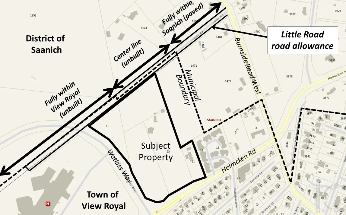
Statutory Rights-of-Way Statutory rights-of-way on the site will be required for staff and public access to the south east corner of the proposed park. Staff access is required for park maintenance and garbage pickup. The statutory rights of way would be registered once the driveways and sidewalks have been constructed in Phase 2.
RECOMMENDATION:
THAT Official Community Plan Amendment Bylaw No. 848, 2012 be given first and second reading;
AND THAT Land Use Amendment Bylaw No. 849, 2012 be given first and second reading;
AND THAT a Public Hearing be scheduled for November 20, 2012 for the bylaws;
AND THAT coincident with final reading of Land Use Bylaw Amendment Bylaw No. 849, 2012, a covenant be registered to secure the following: a. Dedication of the 1.58 ha park as part of Phase 2 of the project; b. Construction trails in or near the park as part of Phase 2 of the project; c. A statutory right-of-way for public and access to the proposed park as part of Phase 2 of the project; and d. Requirement that Building 2 to be constructed as a one storey building
AND FURTHER THAT the $1 million community amenity contribution offered by the applicant be provided coincident with final reading of Land Use Bylaw Amendment Bylaw No. 849, 2012.
SUBMITTED BY:
Jeff Chow, Senior Planner
REVIEWED BY:
Lindsay Chase, MCIP, Director of Development Services
ATTACHMENTS
- Subject Property Map
- Plan 02 – Site Plan and Project Data – Omicron - May 8, 2012
- Plan 1E – Site Plan Option 1 (new site plan) – Omicron – October 4, 2012
- Traffic Impact Assessment (excerpt) - Boulevard Transportation – Oct. 23, 2012 (4 pgs)
Document Images
(3)