TOWN OF VIEW ROYAL COUNCIL REPORT: REZONING APPLICATION 2023-01 - 339, 341, & 345 ISLAND HIGHWAY
A staff report outlining a rezoning application for a 238-unit multi-family rental development, including recommendations for community amenity contributions and a new traffic signal.
TOWN OF VIEW ROYAL COUNCIL REPORT
TO: Council DATE: October 26, 2023 FROM: Stirling Scory, RPP, MCIP, Community Planner MEETING DATE: November 7, 2023
REZONING APPLICATION 2023-01 - 339, 341, & 345 ISLAND HIGHWAY
RECOMMENDATION:
THAT the applicant prepares and executes a legal agreement securing the following items, with contents satisfactory to the Director of Development Services and Director of Engineering, and in a form satisfactory to the Town’s Legal Counsel prior to final adoption of the bylaw:
- Installation of a signalized traffic control light at the intersection of Prince Robert Drive and Island Highway prior to issuance of the Occupancy Permit;
- Community amenity contribution in the amount of $4,000 per residential dwelling prior to issuance of Building Permit;
- A minimum indoor community amenity space of 160 m² (1730 ft²);
- A minimum outdoor BBQ amenity space of 105 m² (1130 ft²);
- A minimum outdoor child play structure area of 168 m² (1810 ft²) and a play structure(s);
- A protected green space area of 4186 m² (45,062.5 ft²);
- The lands comprising the development site, 339, 341, and 345 Island Highway, shall not be sold or otherwise transferred separately;
- The three lots are to be consolidated prior to building permit issuance;
- An Invasive Species Removal and Restoration Plan be provided prior to Development Permit issuance, prepared by a qualified professional. Invasive species removal shall occur prior to the issuance of a building permit, to the satisfaction of a qualified professional;
- A new BC Transit Shelter be acquired and installed solely at the applicant’s cost prior to issuance of an Occupancy Permit and to the satisfaction of BC Transit;
- A fence along the rear yard and side yard of the property must be installed prior to issuance of Occupancy Permit; and
- The applicant provides compensation and relocation assistance for existing tenants in accordance with the Tenant Assistance Plan dated July 10, 2023.
AND THAT a notice be prepared and a Public Hearing be scheduled after first and second reading and prior to third reading of Zoning Bylaw No. 900, 2014, Amendment Bylaw No. 1128, 2023.
PURPOSE:
The purpose of this report is to provide Council with an update on the Rezoning Application for the properties located at 339, 341, and 345 Island Highway. The applicant proposes to rezone the properties from C-5: Tourist Commercial to the RM-3: Mixed Residential Zone, to build a multi-unit residential development, with approximately 238 rental dwelling units. Should Council wish to advance the application to a Public Hearing then Council may consider giving first and second reading of the zoning amendment bylaw at the regular meeting of Council on November 7, 2023.
TIME CRITICAL:
At this time, there are no concerns regarding timing for the municipality.
EXECUTIVE SUMMARY:
The purpose of the rezoning application for the properties located at 339, 341, and 345 Island Highway is to rezone from C-5: Tourist Commercial to the RM-3: Mixed Residential Zone. The proposed development concept includes two six-storey, multi-unit residential buildings with a proposed density of 1.6:1 floor space ratio (FSR). The proposed concept includes 238 rental apartment dwellings with a mix of bachelor, one-, two-, and three-bedroom units. The applicant is also proposing indoor and outdoor amenity space, including a protective greenspace, children’s play area and structure, and barbecue area.
The proposal complies with the use and density provisions of the Mixed Use Residential land use designation in the Official Community Plan (OCP) and therefore, an OCP amendment is not required.
Should Council wish to advance the application to a public hearing, staff recommend that first and second reading of Zoning Amendment Bylaw No. 1128 be considered. In addition, staff are recommending that the applicant register legal agreements on title securing several amenities associated with this proposed development prior to final adoption of the bylaw.
BACKGROUND:
The rezoning application was originally presented to Committee of the Whole (COW) on June 13, 2023, and again on September 12, 2023. Following these meetings, the applicant further revised the application in response to comments provided by the Committee and staff. This report summarizes the proposed changes to the application.
For further background information, the COW reports are attached to this report.
Site Characteristics:
The development site has an area of approximately 12,129 m2. The properties are located on the border of the Harbour and Helmcken Neighbourhoods, identified in the Official Community Plan (OCP).
Table 1- Land Use Summary
| Address | Land Use Designation | Zone | Existing Use | |
|---|---|---|---|---|
| Subject Property | 339, 341, 345 Island Highway | Mixed Residential (MR) | C-5: Tourist Commercial | Multiple dwellings |
| North | 340 Island Highway | Intensive Mixed Used (IMU) | C-6: Tourist Commercial (Campground) | Fort Victoria |
| West | 347 Island Highway and 585 Prince Robert Drive | Mixed Residential (MR) | CD-13: Comprehensive Development (Island Highway) and R2: Duplex Residential | Duplex and single family dwellings |
| East | 333 Island Highway | Community Facility (F) | P-8: Public Safety | Fire Hall and Public Safety Building |
| South | 590, 560, 552, 550, and 542 Prince Robert Drive | Large Lot Residential (R-L) | R-1: Detached Residential (Large Lot) P-7: Utility Corridor | Single-family dwellings and Heddle Park |
Project Information:
A rezoning application addresses zoning related items, including the permitted principal and secondary uses, density, lot coverage, impermeable surface area, and the height and setbacks of buildings.
Zoning Review:
In further review of the application, staff determined that the applicant may use an existing zone, the RM-3: Mixed Residential Zone instead of establishing a new comprehensive development zone, as the proposal generally fits with this standard zone from a use, density, setbacks and lot coverage perspective.
The following data table compares the proposal with the existing C-5: Tourist Commercial Zone and the RM-3: Mixed Residential Zone. An asterisk is used to identify where the proposal does not meet the requirements of the RM-3 zone. The required variance will be addressed at time of Development Permit Application.
Table 2 – Zoning Compliance Summary
| Regulation | Existing C-5: Tourist Commercial Zone | RM-3: Mixed Residential Zone | Proposal |
|---|---|---|---|
| Floor Space Ratio (FSR) | .4:1 | 1.5:1 + .1 where 80% parking underground | 1.6:1 |
| Lot Coverage | 50% | 60% | 29% |
| Impermeable Coverage | 80% | 80% | 71% |
| Building Height (m) | 9 m | 13.5 m | 17.7 m* |
| Front Yard Setback (m) – Prince Robert Drive | 7.5 m | 7.5 m | 8.1 m |
| Side Yard Setback (m) – Heddle Park | 6.0 m | 4.0 m | 9.1 m |
| Rear Yard Setback (m) – Fire Hall | 7.5 m | 7.0 m | 7.0 m |
| Flanking Yard Setback (m) – Island Highway | 3.0 m | 4.0 m | 8.2 m |
- A variance to height is required; the variance will be addressed at time of Development Permit.
Parking Review
The proposal complies with the required number of vehicle parking spaces. Table 3 below provides a summary of the proposed vehicle and bicycle parking for the development. At time of Development Permit Application, staff will work with the applicant to confirm all details of parking provisions in the Zoning Bylaw No. 900, 2014, including dimensions of parking spaces, the location of exterior bicycle racks, and confirmation of the number of energized vehicle and bicycle spaces. Should the applicant request a parking variance, it will be addressed during the Development Permit Application.
Table 3 - Parking Compliance Summary
| Parking by Unit Type | Number of Units | Parking Requirement | Parking Proposed |
|---|---|---|---|
| Studio | 5 | 1 per dwelling unit | 5 |
| 1 Bedroom | 120 | 1 per dwelling unit | 120 |
| 2 Bedroom | 108 | 1.5 per dwelling unit | 162 |
| 3 Bedroom | 5 | 2 per dwelling unit | 10 |
| Total Small Car Parking (30%) | N/A | 90 spaces (maximum) | 4 spaces |
| Electric Vehicle Parking Spaces (Level 2 – 240 Volt) | 1 per space (297 spaces) | 297 spaces | |
| Accessible Parking | 1 per every 100 where 50 or more spaces provided (3 accessible parking spaces) | 3 | |
| Bicycle Parking | 238 dwelling units | 1 per dwelling unit (electrified) + two 5 space racks at each entrance | 238 spaces and racks to be confirmed at DP |
NOTE: all required residential and bicycle parking (Class 1) must be electrified to the specified requirements of the Zoning Bylaw definitions for Energized Electric Vehicle Outlet and Energized Electric Bicycle Outlets.
Unit Mix Overview
The applicant is proposing to provide approximately 238 dwelling units, including studio, one-, two-, and three-bedroom apartments, detailed below. The unit mix may change during detailed design at the building permit stage. A single flex space amenity room is also proposed and would be secured in a legal agreement registered on title.
Table 4 - Conceptual Unit Mix
| Unit Type | Number of Units | % of Total | Size (sq. ft.) |
|---|---|---|---|
| Studio | 5 | 2% | 450 – 575 ft² |
| 1 Bedroom | 120 | 50% | 600 – 710 ft² |
| 2 Bedroom | 108 | 45% | 845 – 905 ft² |
| 3 Bedroom | 5 | 2% | 1,105 ft² |
| Amenity Space | 1 | N/A | 1730 ft² |
Conceptual Design
The applicant has provided conceptual renderings of their proposal for this rezoning application, provided below in Figures 1 to 5. At this time the design details are conceptual only and are intended to illustrate what may be done on site and to provide proof of concept for the proposed rezoning. Form and character of the buildings and associated on-site landscaping will be addressed at time of Development Permit application.
Figure 1 - Conceptual Development Rendering
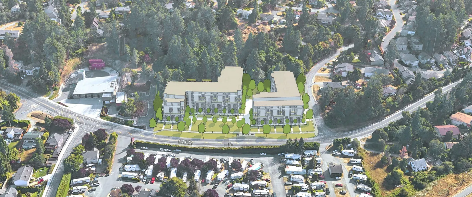
Figure 2 - Conceptual Rendering (Prince Robert Drive and Island Highway) - Southbound
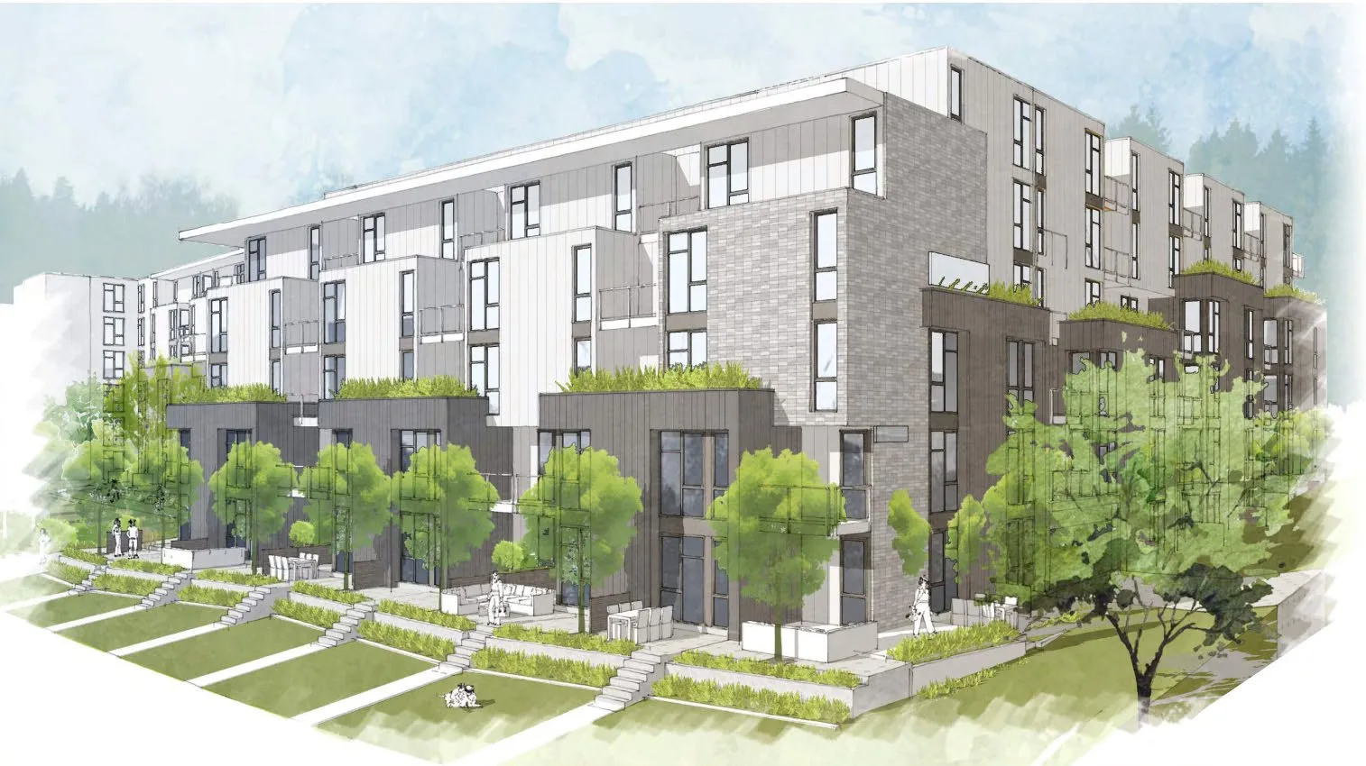
Figure 3 - Conceptual Rendering (Island Highway) - Northbound
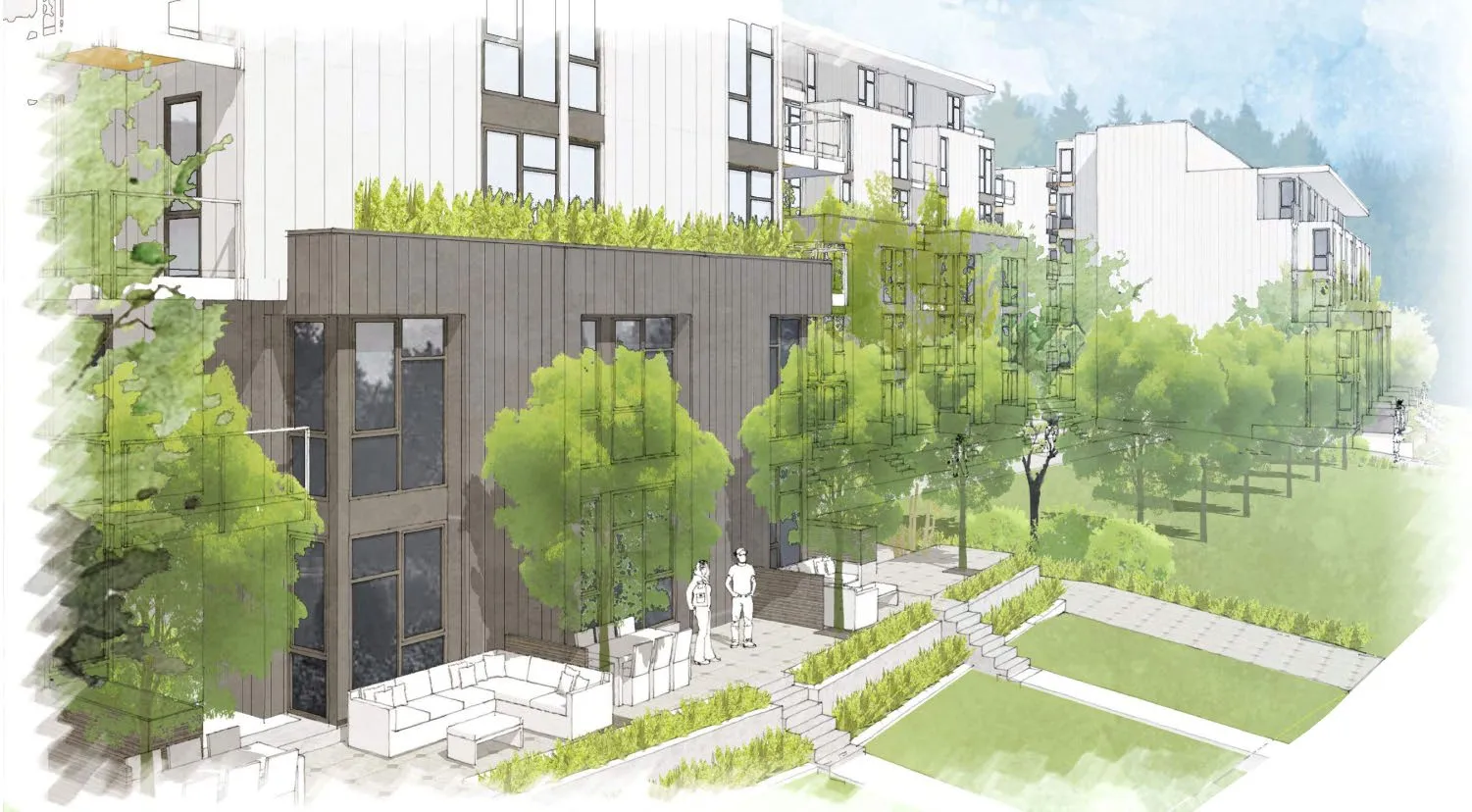
Figure 4 - Conceptual Building Setbacks and Siting
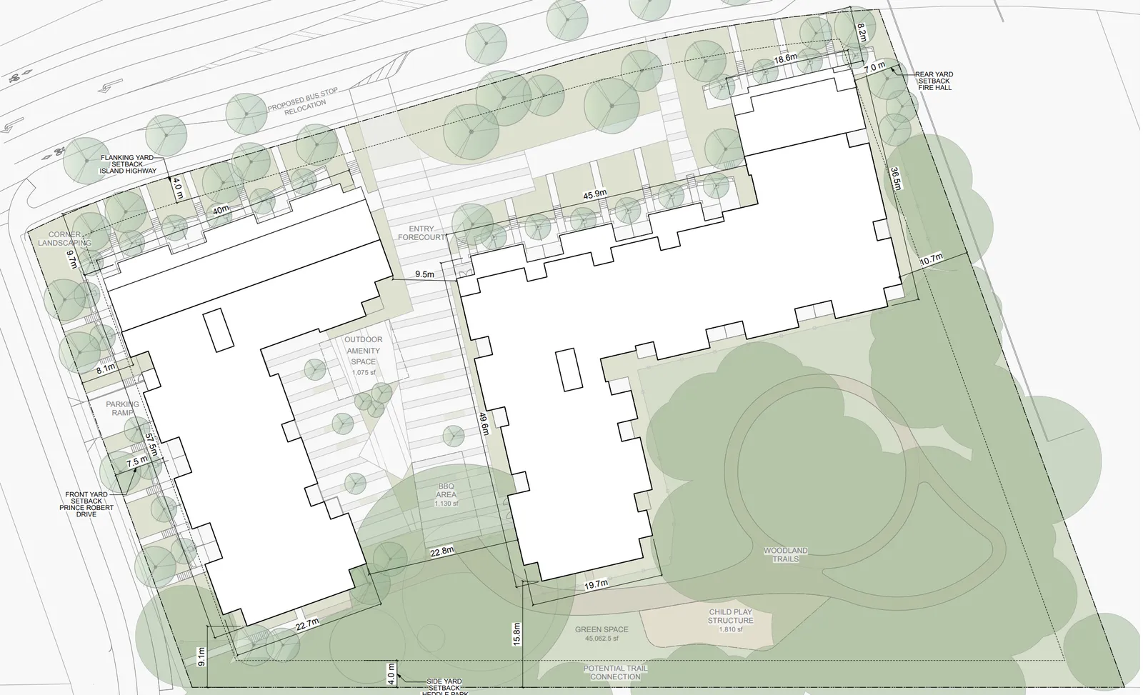
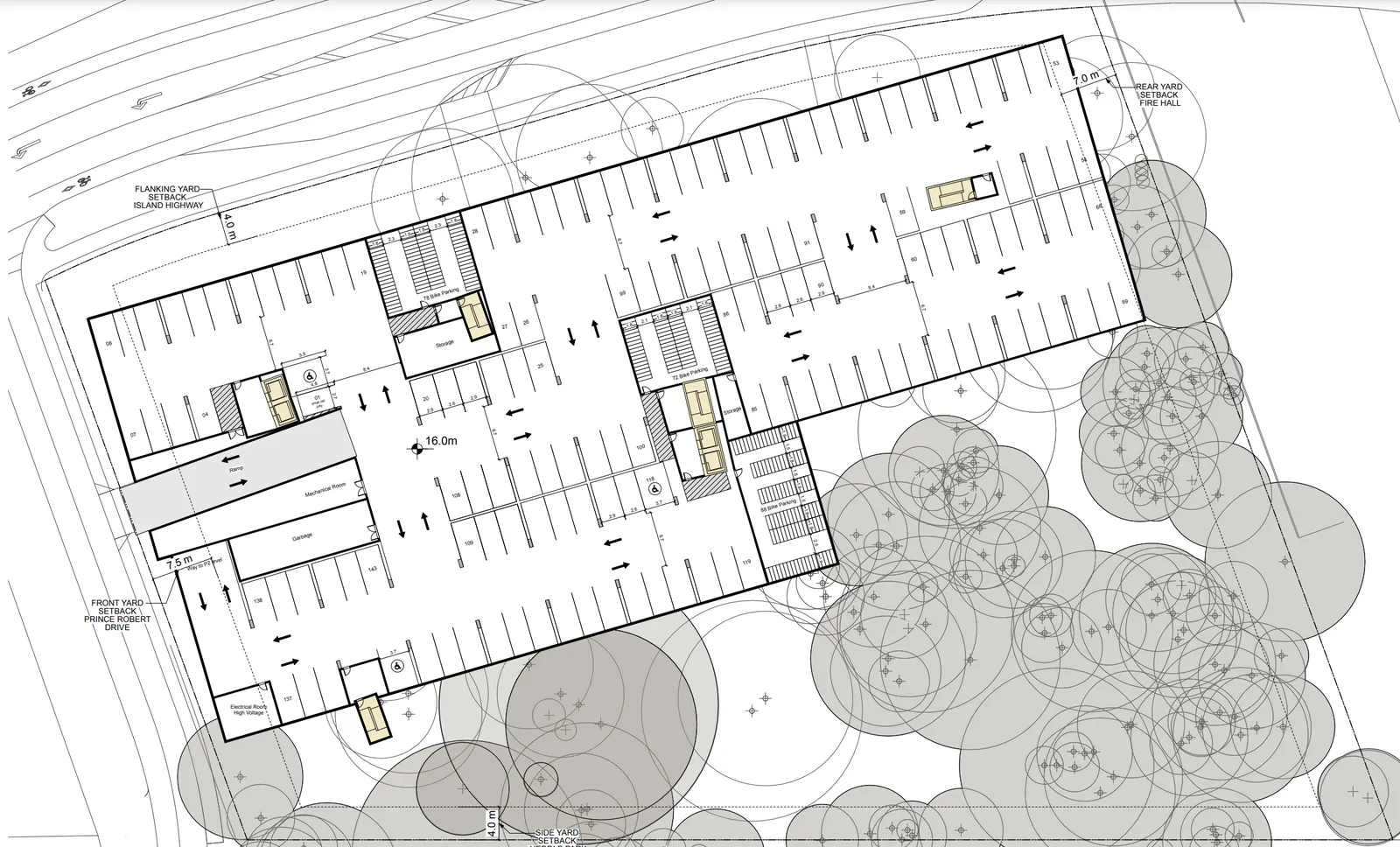
Figure 5 - Conceptual Parking (1st level) Plan, Bicycle Parking, and Garbage
DISCUSSION:
In review of a rezoning application, an evaluation of the proposal’s alignment with the Town’s relevant policies and bylaws is reviewed, including the Official Community Plan No. 811, 2011 and regulations of Zoning Bylaw No. 900, 2014. The analysis of the proposal is done in consideration of land use and potential land use impacts. A comprehensive review of the relevant planning policies is summarized in previous COW reports (see Attachments 13 and 15) as well as a list of the applicable planning policies (see Attachment 10).
Transportation
The applicant has provided the Town with a traffic impact assessment (TIA). In summary, the report recommends that the applicant, at their own expense, complete the following:
- install a new traffic signal at the Island Highway/Prince Robert Drive intersection;
- install a 25 m westbound turn lane on the Island Highway at Prince Robert Drive (for left turning from the Island Highway onto Prince Robert Drive);
- install a sidewalk with landscaped boulevard along the development frontage of the Island Highway; and
- upgrade the existing bus stop on Island Hwy in accordance with BC Transit and Town requirements (complete with bus pad and bus shelter).
The TIA also recommends consideration of converting the centre “painted median” on the Island Highway into a “two-way left turn lane”, between Prince Robert Drive and Burnett Road. The Town’s Transportation Master Plan, its Technical Update, and Subdivision and Development Bylaw supports this; however, the works would require widening the roadway northwards, thus requiring capital work outside the development’s obligations. The Town currently has a capital design project in 2024 to provide a shelf ready street design on the Island Highway, from Helmcken Road to the Colwood Interchange (Project C-076). Staff recommend deferring considerations for a two-way left turn lane until this detail design project is underway, at that time Council may wish to coordinate the widening works concurrently with the applicant’s frontage works to fully upgrade the roadway within the vicinity of this development site.
A cost share between the applicant and the Town for road widening on Prince Robert Drive, as demonstrated in the applicant’s concept plan, will be required to ensure the road remains fully within the Town’s right-of-way.
Frontage improvements are to be in accordance with the Subdivision and Development Bylaw 985, and to incorporate the above noted requirements, shown conceptually in the applicant’s concept plan. Detailed design and installation of all servicing and frontage works will be secured as part of the Servicing Agreement for the development at the Building Permit stage.
Fire Access and Loading
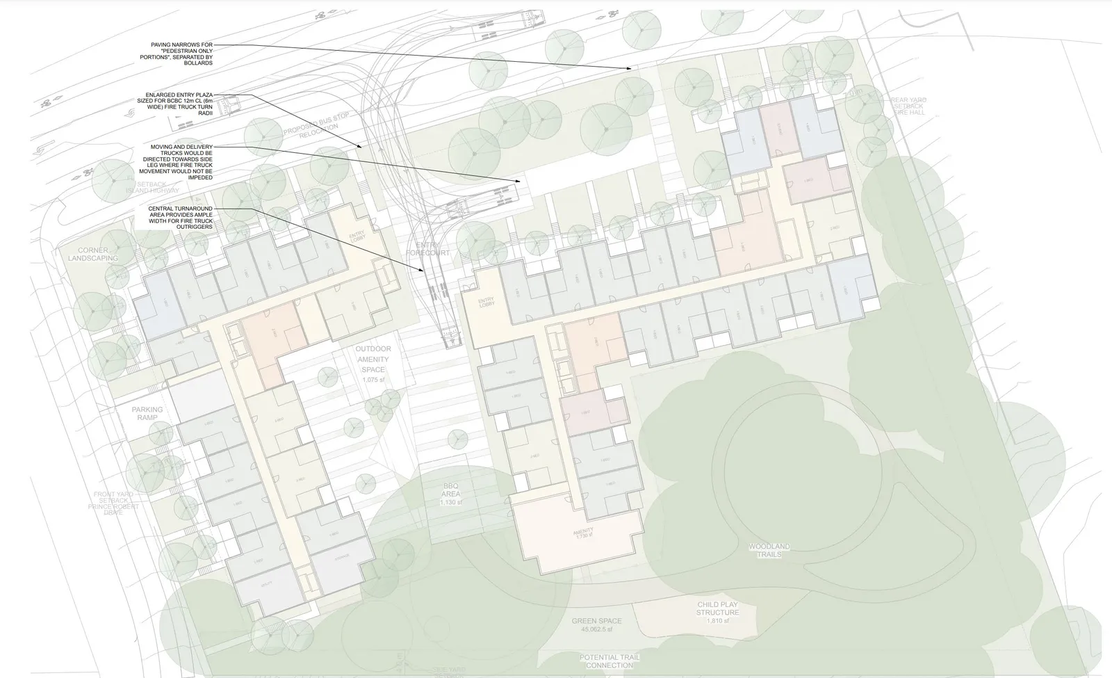
At the September 12, 2023, Committee of the Whole Meeting, staff indicated that fire access was an outstanding issue; it has now been resolved (see Figures 6 and 7). The applicant worked with staff to address the concerns of all departments to come to a solution for fire access and loading. The applicant is proposing to provide a single loading space on the site, which is intended to be used for moving and delivery vehicles. The revised design also allows for a fire engine to access the site from Island Highway.
Accommodating a loading space and fire access on site has resulted in slight design changes to the courtyard, children’s play area, and barbeque location. However, staff believe that these refinements improve the overall site layout by locating the amenity areas in the side yard closer to the green space area, which would be better suited for residents to use and enjoy the outdoor areas. The design details of these outdoor areas will be further addressed at Development Permit.
Figure 6 - Proposed Conceptual Fire Access
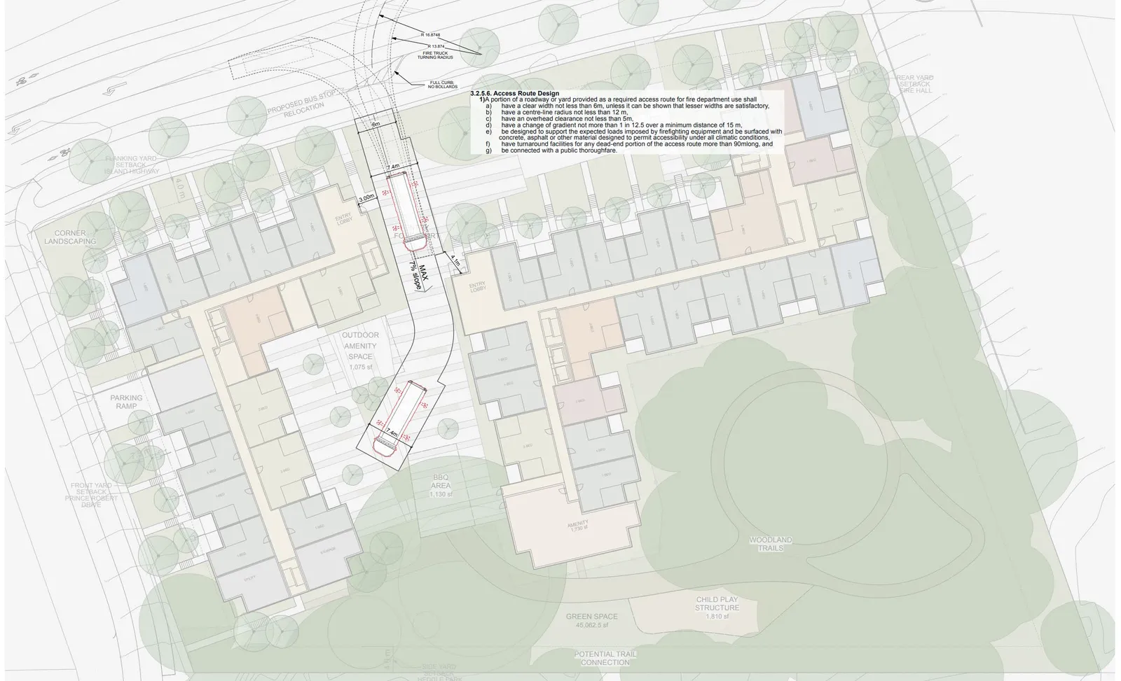
Figure 7 - Proposed Conceptual Fire Access and Loading Area
Traffic Calming
In addition, at the September 12, 2023, Committee of the Whole Meeting, members of the Committee had requested that staff explore opportunities to address the potential impact of ‘rat running’ on pedestrian safety while using Prince Robert Drive. Although a small fraction of trips to and from the development site can be expected to utilize the Prince Robert Drive / View Royal Avenue route through the Harbour District, it is not possible to correlate the resulting impact on pedestrian safety due to those few trips generated by the proposed development. Council may choose to further investigate pedestrian safety beyond the effects of the proposed development as a Town-led initiative, and should Council feel that pedestrian safety improvements are necessary for the greater neighbourhood, Council may use community amenity contributions provided by the applicant for this application to establish further traffic calming measures in the neighbourhood.
Invasive Species Removal
The applicant’s arborist report has made note of invasive species on-site, which include English Ivy. Staff have also observed other invasive species on-site, such as Daphne / Spurge-laurel. Staff recommend securing the removal of the invasive species prior to issuance of building permit in a legal agreement registered on title, as a condition of rezoning.
Tree Impacts
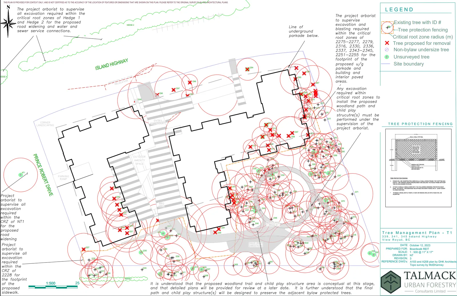
An arborist’s report (Attachment 7) indicates that a total of 43 trees are proposed for removal, subject to future assessment. A total of 125 on-site trees and 3 hedges have been marked for retention, of which there are 19 municipal trees and 3 hedges are in the proximate location of the development site. The report confirms that there will be no off-site private trees that will be impacted. Figure 8 below illustrates the proposed tree removal and retention plan.
The change in location of the children’s play structure and outdoor barbeque area does not impact the retention of trees; the number of trees to be removed is unchanged.
The applicant is required to provide replacement trees at a 2:1 ratio or cash payment for the proposed trees to be removed. At a 2:1 ratio the applicant would be required to replant 86 trees. While the renderings provided show some trees as part of the landscaping, it is unclear whether or not the replacement ratio will be satisfied. This will be confirmed at Development Permit.
A Tree Permit will be required at time of Building Permit Application.
Figure 8 - Proposed Tree Removal and Preservation Plan
Heddle Park Trail Connection
At the Committee of the Whole meeting on September 12, 2023, the Committee discussed a trail connection between the development site and Heddle Park. The current state of this portion of Heddle Park, i.e. the lands that abut the subject properties, is an unopened, undeveloped linear piece of land.
Council may wish to note that the Town completed a recent survey to gauge public support for a trail along Heddle Park. The survey was sent to twelve adjacent properties and only two surveys out of eight surveys submitted were in favour of a trail. If a trail was to be built, despite the lack of support, the adjacent neighbours wanted a fence. A fence would formalize the park’s boundaries. The applicant is willing to construct a fence along the south property line adjacent to the linear greenspace.
The applicant has expressed concerns about providing a future trail connection without there being a trail already in this location. In previous discussions at COW, staff have also expressed concern and do not see any benefit of providing a trail connection to this unopened portion of Town owned land given the uncertainty of a potential trail at this location in the future. If Council would like the applicant to provide a trail connection to this undeveloped portion of Heddle Park, that can be secured in legal agreement, i.e. a covenant. The detailed design of the connection would be confirmed at development permit. Development of this unopened portion of Heddle Park as a formal trail will be at cost to the Town via a capital project.
On-Site Outdoor Amenities
The applicant is proposing to include the following outdoor amenities as part of the proposed development:
Table 5 - Amenity Space Summary
| Amenity | Area |
|---|---|
| Barbeque area | 106 m² |
| Children’s play area/playground | 105 m² |
| Courtyard area/open space | 100 m² |
| Greenspace | 4186 m² |
Figure 9 - Proposed On-site Amenity Spaces
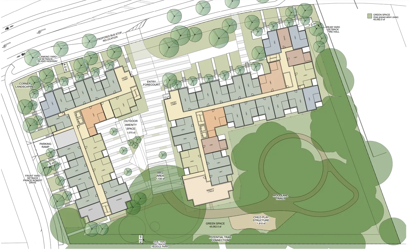
The amenities would provide substantial on-site benefits to the future tenants of the building and will further advance objectives and policies in the OCP; therefore, staff recommend securing the amenities in a legal agreement to ensure they are provided as a condition of rezoning. Staff also recommend that the greenspace be secured in perpetuity to ensure that it is protected for the lifetime of the development. The applicant has expressed concerns with staff regarding the registration of a greenspace covenant on title; however, should the site be redeveloped again in the future (i.e., following the end of life of the proposed development), the greenspace covenant could be revisited at that time as part of a new proposal for the site.
Foundation and Underpinning
The applicant must obtain permission from neighbouring property owners to site underpinnings in construction of the foundation or parkade structure, should it be required. Where the affected lands may be those owned by the Town, the landowner must be responsible for receiving an encroachment agreement from the Town. Where those affected lands are on Island Highway, the owner must also receive approval from the Capital Regional District given the proximity of their water supply and distribution infrastructure.
Amenity Contributions
In accordance with the Town’s community amenity contribution (CAC) Policy, the applicant has agreed to pay $4,000 per dwelling unit even though the land lift analysis prepared by land economist, Mulholland and Associates, confirmed that the proposal results in no lift following the rezoning of the lands. The total amenity contribution would be approximately $952,000.00 (based on 238 dwelling units). The proposed cash amenity contribution will be secured in a legal agreement and will be paid to the Town prior to issuance of the building permit, should the rezoning be approved.
Staff had further conversations with the applicant for the negotiation of affordable housing units to further advance the housing objectives in the OCP, and to address the housing affordability crisis in the greater Victoria region. The applicant indicated to staff that it is not financially feasible to provide affordable housing units in addition to the other costs and amenities provided with this development.
Tenant Assistance Plan
The applicant has provided a tenant assistance and relocation plan (Attachment 8). This application is exempt from the Tenant Assistance Policy that was adopted by Council due to the timing of the application; however, the applicant’s plan is consistent with the policy and in some cases goes beyond the requirements. Compensation outlined in the plan would be secured in a legal agreement, as a condition of rezoning.
SUSTAINABILITY/CLIMATE CHANGE IMPACTS:
The proposal will impact the existing urban forest in the short term, with a reduction of forty-three trees on the development site. However, there is opportunity long term for the urban forest on this site to recover through a combination of landscaping and tree replacement, and natural regrowth of the existing green space on the site.
The proposal must meet Step 2 of the British Columbia Energy Step Code at time of building permit application. The applicant has completed the Town’s Sustainability Checklist, which is attached to this report (Attachment 9).
FINANCIAL IMPLICATIONS:
Should the proposed rezoning be adopted, the Town will be responsible for maintaining a new signalized intersection, sidewalks, a boulevard, and new street trees once installed by the applicant.
CONCLUSION:
The proposal complies with the RM-3: Mixed Residential Zone, except for the proposed variance to building height, which would be considered at Development Permit. In addition, the proposal complies with the Mixed Residential land use designation in the OCP. The applicant has worked with staff to address comments concerning fire access, transportation, traffic calming, and location of the outdoor amenity spaces. Staff recommend that Council consider first and second reading of Zoning Amendment Bylaw No. 1128 and advance the application to a Public Hearing.
ALTERNATIVES:
Option 1: Approve the recommended motion with amendments
THAT Council approve the list of secured covenant items on the condition that the following amendments be made:
Should Council consider this alternate motion, Council must be explicit in what amendments to the recommended motion are required.
Option 2: Decline the application
THAT Council decline Rezoning Application 2023-01, 339, 341, 345 Island Highway.
Should Council consider this alternate motion, the application file is closed. The applicant may reapply, but it must be a new application.
| CONCURRENCE: | Initials | Comments |
|---|---|---|
| Acting Chief Administrative Officer | SJ | Recommend approval. |
| REVIEWED BY: | Initials |
|---|---|
| Director of Corporate Administration | N/A |
| Director of Finance | N/A |
| Director of Development Services | LT |
| Director of Engineering and Parks | |
| Director of Protective Services | PH |
ATTACHMENTS:
- Letter to Mayor and Council – Rezoning Application
- Letter to Mayor and Council – Community Amenity Contributions
- Conceptual Architectural Site Plan and Building Design Drawings
- Conceptual Frontage and Servicing Plan
- Conceptual On-site Turning Templates
- Traffic Impact Assessment
- Arborist Report and Tree Protection Plan
- Tenant Relocation and Assistance Plan and Rent Roll
- Sustainability Checklist
- List of Relevant Official Community Plan Policies
- Landlift Analysis
- Community Engagement Summary
- Committee of the Whole Report June 13, 2023
- Committee of the Whole Minutes June 13, 2023
- Committee of the Whole Report September 12, 2023
- Committee of the Whole Minutes September 12, 2023
Document Images
(2)