ATTACHMENT 6: 339 / 341 / 345 ISLAND HIGHWAY Traffic Impact Assessment
An assessment report by WATT Consulting Group evaluating current and projected traffic conditions and requirements for the proposed development site.
ATTACHMENT 6
339 / 341 / 345 ISLAND HIGHWAY
Traffic Impact Assessment
Author: MJ Oh – Transportation Technologist Reviewer: Kristen Machina, P.Eng. – Senior Transportation Engineer
WATT VICTORIA #302, 740 Hillside Avenue Victoria, BC V8T 1Z4 (250) 388-9877
Prepared For: Boardwalk REIT Date: 10 July 2023 Our File No: 3425.B01
WATTCONSULTINGGROUP.COM
TABLE OF CONTENTS
1.0 INTRODUCTION ................................................................................................... 1 1.1 Study Area ..................................................................................................................... 1 2.0 EXISTING CONDITIONS ..................................................................................... 2 2.1 Land Use ......................................................................................................................... 2 2.2 Road Network ............................................................................................................... 2 2.3 Traffic Volumes ............................................................................................................. 3 2.4 Traffic Modelling – Background Information ....................................................... 4 2.5 2022 Existing Traffic Conditions ............................................................................. 5 3.0 POST DEVELOPMENT ........................................................................................ 6 3.1 Proposed Land Use ..................................................................................................... 6 3.2 Site Access ..................................................................................................................... 6 3.3 Trip Generation ............................................................................................................. 7 3.4 Trip Assignment ........................................................................................................... 8 3.5 2025 Opening Day Background Conditions ....................................................... 9 3.6 Opening Day Post Development Conditions ................................................... 11 4.0 2035 10-YEAR HORIZON TRAFFIC CONDITIONS .................................... 13 4.1 2035 Background Conditions ............................................................................... 14 4.2 2035 Post Development Analysis Results ........................................................ 15 5.0 OPERATIONAL CONSIDERATIONS .............................................................. 17 5.1 Improvements for Island Highway / Prince Robert Drive ............................. 17 5.2 Left Turn Lane ............................................................................................................ 18 5.3 Signal Warrant Review for 4-Leg Island Hwy / Prince Robert Drive ....... 19 5.3.1 Signal Warrant Analysis .......................................................................... 20 5.3.2 Traffic Signal Warrant Result ................................................................. 21 5.4 Feasibility Review of On-street Parking ............................................................ 22 6.0 ACTIVE TRANSPORTATION ........................................................................... 23 6.1 Pedestrians and Cycling Facilities ....................................................................... 23 6.2 Transit ........................................................................................................................... 24 7.0 PARKING FACILITY REVIEW .......................................................................... 24 8.0 TRANSPORTATION DEMAND MANAGEMENT.......................................... 24 9.0 CONCLUSION ..................................................................................................... 25 10.0 RECOMMENDED IMPROVEMENTS ............................................................... 26
APPENDICES
Appendix A: Synchro Information Appendix B: Preliminary Left Turn Lane Design Appendix C: Traffic Signal Warrant Results Appendix D: Synchro Results
LIST OF FIGURES
Figure 1: Study Area and Site Location ............................................................................................. 1 Figure 2: 2022 Existing Volumes ........................................................................................................ 4 Figure 3: Site Plan and Access ............................................................................................................. 7 Figure 4: Trip Assignment ..................................................................................................................... 9 Figure 5: 2025 Opening Day Background Volumes ................................................................... 11 Figure 6: Opening Day Post Development Volumes .................................................................. 13 Figure 7: 2035 Ten-year Horizon Background Volumes .......................................................... 13 Figure 8: 2035 Post Development Volumes ................................................................................. 16 Figure 9: Left Turn Lane Warrant Review ..................................................................................... 18
LIST OF TABLES
Table 1: 2022 Existing Conditions ...................................................................................................... 6 Table 2: Peak Hour Trip Generation Rates ....................................................................................... 8 Table 3: Estimated Development Trips .............................................................................................. 8 Table 4: Distribution Percentages of Site Trips .............................................................................. 8 Table 5: 2025 Opening Day Background Conditions ................................................................ 10 Table 6: 2025 Opening Day Post Development Conditions .................................................... 12 Table 7: 2035 Background Conditions ........................................................................................... 14 Table 8: 2035 Post Development Conditions ............................................................................... 16 Table 9: Delay Comparison between 3-Leg and 4-Leg Options ............................................ 19 Table 10: Northbound Delays at Island Hwy / Prince Robert Dr ............................................ 21 Table 11: On-site Parking Requirements ....................................................................................... 24
1.0 INTRODUCTION
Watt Consulting Group was retained by Boardwalk REIT to conduct a traffic impact assessment for a proposed residential development at 339, 341, and 345 Island Highway in the Town of View Royal. This study assesses traffic impacts of the proposed multi-family residential buildings, reviews the site access, and assesses the need for any mitigation measures. The study reviews the existing traffic operations along with the post development and long-term conditions for all modes of transportation.
1.1 STUDY AREA
See Figure 1 for the study area and location. The study area includes the following intersections:
- Island Highway / Prince Robert Drive
- Island Highway / Burnett Road
- Island Highway / Jedburgh Road
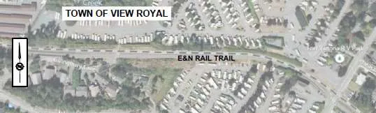
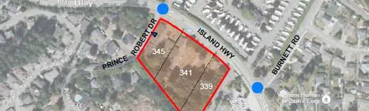
Figure 1: Study Area and Site Location
2.0 EXISTING CONDITIONS
2.1 LAND USE
The proposed development site is composed of three residential lots (339 / 341 / 345 Island Highway) and the existing land use is multi-family residential rental units. The surrounding area of the development is mostly residential along Island Highway and Prince Robert Drive. The View Royal Fire Department buildings were recently constructed just east of the proposed site on Island Highway. To the north, across from the development, there is the Fort Victoria RV Park.
2.2 ROAD NETWORK
The proposed development is located on the south side of Island Highway between Prince Robert Drive and View Royal Fire Department. Island Highway is under the jurisdiction of the Ministry of Transportation and Infrastructure. Burnett Road and Jedburgh Road are under the jurisdiction of the Town of View Royal. All roads within the study area have a maximum speed limit of 50 km/h. A description of all relevant roads in the area is provided below.
Island Highway is a two-lane highway with a functional classification as a Major Road. There are many private property accesses present, and the turning movements associated with them cause conflict and delay along the corridor. There are bike lanes on both sides, but limited sidewalks along most of the roadway (new sidewalk installed along the View Royal Fire Department frontage).
Prince Robert Drive is a two-lane local road (site access road), which faces the west side of the development. There is no sidewalk and limited shoulders provided along the roadway.
The intersection of Island Highway / Prince Robert Drive is stop-controlled with no separate turn lanes. Sight distance for northbound left turning traffic (looking to the left along the highway) from Prince Robert Drive is limited due to the horizontal curvature and vegetation.
Document Images
(6)