Report to Committee of the Whole Re: Request to Amend Covenant for Erskine Lane / Watkiss Way Roundabout
A staff report evaluating the feasibility of a roundabout versus a signalized intersection at Erskine Lane and Watkiss Way for a 336-unit rental development.
Report to Committee of the Whole Re: Request to Amend Covenant for Erskine Lane / Watkiss Way Roundabout Meeting Date: September 12, 2023
If the Committee supports consideration of the proposal, a public hearing would be scheduled prior to Council’s decision on the request.
BACKGROUND:
9 Erskine Lane was rezoned in 2020 to permit a 336-unit rental apartment development that is now under construction. Covenant CA8718173 (Attachment 1) was registered in conjunction with the rezoning to secure a number of community amenity contributions, most notably the installation of a roundabout at the Watkiss Way / Erskine Lane intersection (see Figure 1).
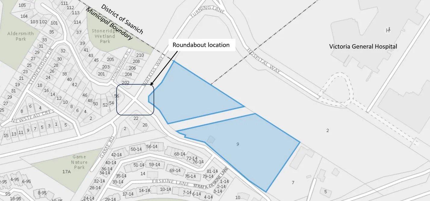
Figure 1. Roundabout location
DISCUSSION:
As part of the building permit process, the applicant (owner of 9 Erskine Lane) entered into a works and services agreement with the Town and provided security deposits to ensure the construction of the intersection improvements.
In the letter of request (Attachment 2) the applicant indicates that when working on the detailed design, they found that the space required for the roundabout coupled with the topography would affect land and properties near the intersection.
Engineering Review: Roundabout
Council may recall at the May 2, 2023 regular Council meeting that a staff report was presented recommending the installation of an oval roundabout instead of the circular roundabout. The purpose of this change was generally twofold: to improve pedestrian accessibility, and to reduce the disturbance area of the roundabout. Council moved in favour of this change and staff proceeded to work with the applicant to make the needed adjustments.
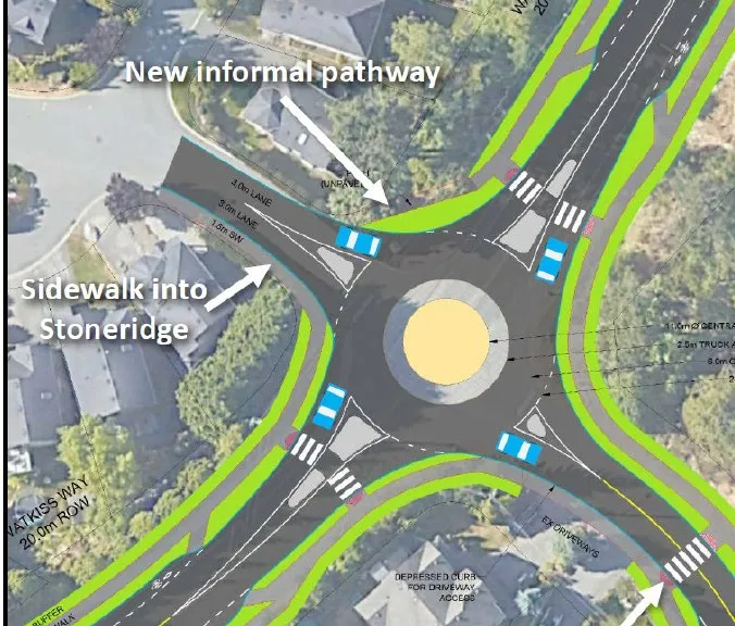
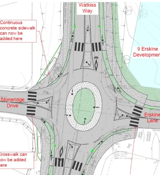
Figure 2. Original (Circular) Versus Revised (Oval) Roundabout
As the applicant’s engineering team continued with the oval roundabout design, additional detailed design investigations confirmed that the change would not be sufficient to provide these improvements. Notably, the WATT Report (Attachment 3) confirmed that:
- the sidewalk at the Stoneridge Drive crosswalk was required to be extended further down the hill to meet Town specifications as well as its active transportation expectations. As a result, recent geotechnical and civil engineering investigations confirmed that the site grading work would still encroach into private property, specifically for the corner properties at the Stoneridge Drive / Watkiss Way intersection; and
- detail design further indicated that additional trees would need to be removed along Watkiss Way to accommodate the roundabout. Some residents and members of the public have commented on concerns regarding removal of trees due to the roundabout.
Furthermore, the WATT Report indicated that:
- the Town should not sacrifice on a narrower sidewalk within the roundabout to save space and trees as it would increase conflicts between pedestrians and cyclists;
- the Town should not consider shifting the crosswalk at Stoneridge Drive closer towards Watkiss Way, as this would increase pedestrian conflicts and collision potential (rear ends); and
- of the 10+ iterations that were done to move and shift the roundabout, none provided an answer that could fit within the road right of way and provide the needed safety measures to warrant the preservation of a roundabout design.
Given the findings of the WATT Report, and the fact that the Town is currently required to fit the design within the road right of way, Staff is in favour with revising the traffic control type to a traffic signalized intersection.
At the time of rezoning, a roundabout was chosen by the applicant due to their public engagement process, which resulted in the need to improve traffic calming on Watkiss Way while also providing less impeded access from Erskine Lane to Watkiss Way (reduce stoppages or queuing). Per the WATT report, a signalized intersection could still accommodate this to an extent by increasing “friction” to the roadway: narrowing and / or reducing the visual openness of the roadway.
To achieve this, should Council consider amending the intersection from a roundabout to a signalized intersection, staff recommend that the following additional measures be required of the applicant to improve traffic calming and accessibility for all road users, and that this is to be proven out in a concept plan prior to public hearing:
- prioritize the signal timing for Erskine Lane to accommodate vehicular flow for the peak AM period: at a time when residents are leaving Erskine Lane to commute to work;
- increase “friction” by reducing the visual openness. This may be achieved by slightly changing the alignment of Watkiss Way at the approaches of the intersection, reducing the straight alignment and requiring vehicles to slow down before the intersection. This could also be achieved by installing a low height median which would provide a visual cue. Assurance of sight lines would still be required and would be proven out at detail design;
- increase “friction” and improve safety of active travellers by requiring the revised frontage improvements to adhere to the design guidelines of the Town’s Active Transportation Network Plan (Section 5.3 of the plan). This includes:
- sidewalk width on Watkiss Way: Collector road, separated = 1.8m width (consistent with Subdivision and Development Bylaw);
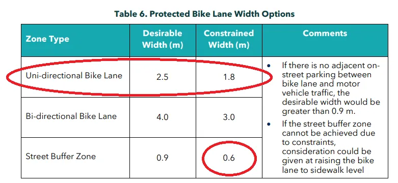
- boulevard width: basic furnishing zone, any land use = 1.5-2.0m width (within range of the Subdivision and Development Bylaw); Protected bike lane on Watkiss Way: buffered bike lane = 1.8m-2.1m width with a 0.6m minimum buffer zone;
Active Transportation Network Plan Design Guidelines
Table 4. Recommended Sidewalk Facility Widths
| Land Use / OCP Designations | Road Type | Separation | Side | Desirable Width (m) | Constrained Width (m) |
|---|---|---|---|---|---|
| Low - Medium Density Residential | Local | Non-separated or Separated | One side | 1.8 | 1.8 |
| Collector / Arterial | Separated | Both sides | 1.8 | 1.8 | |
| High Density Residential | Local | Non-separated or Separated | One side | 2.1 | 1.8 |
| Collector / Arterial | Separated | Both sides | 2.4 | 1.8 | |
| Commercial Mixed Use / Community Corridor / Neighbourhood Centre / Town Centre | Any | Separated | Both sides | 2.4 - 3.0 | 2.1 |
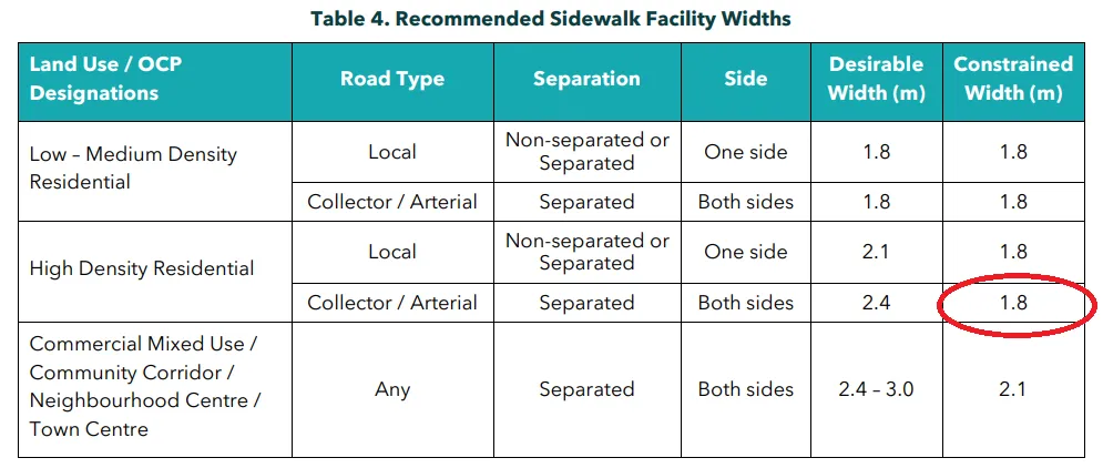
Table 5. Recommended Furnishing Zones for Sidewalk Facilities
| Furnishing Zone Type | Land Use | Desirable Width (m) | Constrained Width (m) | Comments |
|---|---|---|---|---|
| Basic | Any | 2.0 | 0.6 |
|
| Enhanced | Commercial Mixed Use / Town Centre | 3.0 - 5.0 | 3.0 |
|
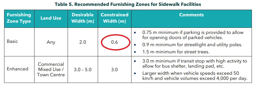
Table 6. Protected Bike Lane Width Options
| Zone Type | Desirable Width (m) | Constrained Width (m) | Comments |
|---|---|---|---|
| Uni-directional Bike Lane | 2.5 | 1.8 |
|
| Bi-directional Bike Lane | 4.0 | 3.0 | |
| Street Buffer Zone | 0.9 | 0.6 |
|
- further “friction” could be achieved by installing physical barriers within the buffer zone of the bike lane (i.e. knock down bollards, or concrete barriers); and
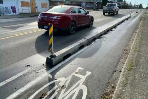
Protected Bike Lane “Physical Barrier” Example
- pedestrian signalized crossings and accessibility: leading pedestrian intervals, curb ramps per BC Active Transportation Design Guide.
Engineering Review: 3.0m Multi-Use Path
Per the applicant’s Letter of Request (Attachment 2), the applicant is offering to substitute the planned sidewalk along Erskine Lane with a 3.0m wide multi-use path that extends the length of Erskine Lane, connecting to the Galloping Goose Regional Trail.
Per the Town’s Active Transportation Network Plan (Section 5.3), multi-use pathways typically accommodate bi-directional travel and are commonly shared spaces between walkers, rollers, and cyclists. Typically, multi-use paths are applicable when vehicle volumes are in the range of 2,500 to 4,000 per day and/or vehicle speeds exceed 50km/hr.
Staff is not in favour of a multi-use path on Erskine Lane for the following reasons:
- Erskine Lane is relatively steep in nature. By installing a bi-directional facility on the north side of Erskine Lane, cyclists travelling downhill would be in close proximity to vehicles travelling uphill, potentially creating an unsafe environment for active travellers;
- maintenance of the multi-use path would fall on the Town. With steep slopes in mind, the maintenance expectations in the winter months could accrue higher costs to the Town;
- the Active Transportation Network Plan already proposes a multi-use path on Talcott Road, which is the adjacent roadway south of Erskine Lane. Talcott Road is better suited for a multi-use path due to shallower slopes, more boulevard space (and thus better separation from traffic), and direct proximity to the Eagle View Elementary School; and
- the anticipated vehicle volumes are expected to be significantly less than 2,500-4,000 per day and vehicle speeds are expected to be less than 50km/hr. With the Active Transportation Plan already considering Talcott Road as a roadway befitting of an all ages and ability corridor, the same treatment is not required along Erskine Lane.
Staff recommend that the existing requirements (buffered bike lane and concrete sidewalk) be maintained for Erskine Lane.
SUSTAINABILITY/CLIMATE CHANGE IMPACTS:
This issue has no significant sustainability or climate change impacts. In either scenario, active transportation features such as sidewalks and bicycle lanes would be maintained. Transit access would be preserved, and a bus pad and shelter would be installed on Watkiss Way in accordance with previous requirements.
FINANCIAL IMPLICATIONS:
If the covenant is to be amended to construct a signalized intersection instead of a roundabout, it is understood the applicant’s commitment to construct/pay for the intersection improvements would remain a term of the covenant. Upon completion, the works would become Town assets. Additional maintenance costs would be prevalent for a signalized intersection than a roundabout, due to the need to maintain the traffic signals.
ALTERNATIVES:
The Committee could recommend that Council reject the proposal, in which case development would continue in accordance with Covenant CA8718173. However, given the detailed design engineering investigations that took place by the applicant, there are land based concerns in fitting the roundabout within the road right of way, and additional sacrifices to pedestrian and cyclist safety would be required. Therefore, this option is not recommended by Staff.
CONCLUSION:
Staff supports the proposal for a signalized intersection. By occupying less space there would be less disturbance to the immediate area and adjacent residents. Staff recommends that additional traffic calming measures be provided as part of this proposal to discourage speeding and enhance active transportation on this section of Watkiss Way. Staff does not support the request for a multi-use path on Erskine Lane as it is less suitable than a multi-use path on Talcott Road, which is proposed to have a multi-use path per the Active Transportation Network Plan.
If the Committee supports consideration of the proposal, then a public hearing would be scheduled This is required because provision of the roundabout was a zoning consideration and similar notification would be conducted. Staff will require the applicant to provide a revised concept plan proving out the signalized intersection design requirements as part of Public Hearing. Following the public hearing, staff would work with the applicant on the draft terms of the covenant modification prior to Council’s decision on the request.
CONCURRENCE:
| CONCURRENCE: | Initials | Comments |
|---|---|---|
| Chief Administrative Officer | KA | Recommend Approval |
REVIEWED BY:
| REVIEWED BY: | Initials |
|---|---|
| Director of Corporate Administration | n/a |
| Director of Finance | n/a |
| Director of Development Services | LT |
| Director of Engineering and Parks | IL |
| Director of Protective Services | n/a |
ATTACHMENTS:
- Covenant CA8718173 (24 pages)
- Letter of Request from Matthew Fitzgerald, WestUrban Developments
- Design Issues Memo, Watt Consulting, August 31, 2023 (17 pages)
- Geotechnical Report on retaining walls – Ryzuk Geotechnical, August 15, 2023 (2 pages)
- Transportation Impact Assessment, Watt Consulting, (102 pages)