9 ERSKINE LANE Traffic Impact Assessment
A traffic impact study evaluating the long-term operational effects of a proposed 336-unit residential development on the local road network.
9 ERSKINE LANE
Traffic Impact Assessment
Author: Kristen Bacler Transportation Technologist
Reviewer: Andy Kading, P.Eng., P.E. Senior Transportation Engineer
Prepared For: WestUrban Developments Date: August 17, 2023 Our File No: 2755.B01
WATT VICTORIA 302 – 740 Hillside Ave Victoria, BC V8T 1Z4 250-388-9877
TABLE OF CONTENTS
- 1.0 INTRODUCTION ................................................................................................... 4
- 1.1 Study Area ............................................................................................................ 4
- 1.2 The Site Today ..................................................................................................... 5
- 1.3 Proposed Development ..................................................................................... 5
- 1.4 This Report ............................................................................................................ 5
- 2.0 TRANSPORTATION CONTEXT ........................................................................ 7
- 2.1 Land Use ................................................................................................................ 7
- 2.2 Road Network ...................................................................................................... 7
- 2.3 Transit Network ................................................................................................. 10
- 2.4 Cycling Network ................................................................................................ 12
- 2.5 Pedestrian Environment .................................................................................. 13
- 2.6 Area Travel Characteristics ............................................................................. 14
- 3.0 DEVELOPMENT PROPOSAL ........................................................................... 15
- 3.1 Site Access .......................................................................................................... 15
- 3.2 Sight Distance .................................................................................................... 15
- 4.0 TRAFFIC VOLUMES........................................................................................... 17
- 4.1 Traffic Analysis Scenarios and Design Periods.......................................... 17
- 4.2 Corridor Growth Rate ....................................................................................... 17
- 4.3 Concurrent Development Traffic Volumes .................................................. 17
- 4.4 Existing Traffic - Intersection Analysis ........................................................ 18
- 4.5 New Site Traffic Volumes ................................................................................ 21
- 4.6 2023 Post-Development Traffic Volumes ................................................... 23
- 4.7 Background Horizon Year 2033 Traffic Volumes ...................................... 25
- 4.8 Full Build Out Post-Development Horizon Year 2033 Traffic Volumes ................... 26
- 5.0 TRANSPORTATION DEMAND MANAGEMENT .......................................... 28
- 5.1 Electric Bicycles .................................................................................................. 28
- 5.2 Secure Bicycle Parking ..................................................................................... 28
- 5.3 Carpooling ........................................................................................................... 29
- 5.4 Carshare ............................................................................................................... 29
- 5.5 TDM Impact on Traffic ..................................................................................... 29
- 6.0 TRAFFIC OPERATIONS ANALYSIS ............................................................... 30
- 6.1 Methodology ....................................................................................................... 30
- 6.2 Input and Calibration Parameters ................................................................. 30
- 6.3 Existing Traffic Operations - 2023 ................................................................ 30
- 6.4 2023 Traffic Operations with 9 Erskine Lane Full Build Out .................. 33
- 6.5 Horizon Year Traffic Operations - 2033 ...................................................... 37
- 7.0 LEFT TURN LANES ............................................................................................ 43
- 8.0 CONCLUSIONS ................................................................................................... 44
- 9.0 RECOMMENDATIONS ...................................................................................... 44
FIGURES
- Figure 1: Study Intersections and Site Location ............................................................................. 4
- Figure 2: Proposed Site Plan ................................................................................................................. 5
- Figure 3 – Existing Transit Network ................................................................................................ 11
- Figure 4: Existing Cycling Network .................................................................................................. 12
- Figure 5 - Existing Traffic Volumes - AM ....................................................................................... 20
- Figure 6 - Existing Traffic Volumes - PM ....................................................................................... 20
- Figure 7 - AM Trip Assignment – 9 Erskine Lane ........................................................................ 23
- Figure 8 - PM Trip Assignment – 9 Erskine Lane ........................................................................ 23
- Figure 9 - Existing and 9 Erskine Lane Traffic Volumes – AM ................................................ 24
- Figure 10 - Existing and 9 Erskine Lane Traffic Volumes – PM .............................................. 24
- Figure 11 – Background 2033 Traffic Volumes – AM ................................................................ 25
- Figure 12 – Background 2033 Traffic Volumes – PM ................................................................ 26
- Figure 13 - Horizon Year 2033 Traffic Volumes - AM ............................................................... 27
- Figure 14 - Horizon Year 2033 Traffic Volumes - PM ............................................................... 27
- Figure 15 – 2023 AM Site Accesses ............................................................................................... 35
- Figure 16 – 2023 PM Site Accesses ................................................................................................ 35
- Figure 17 – 2033 Site Accesses AM ............................................................................................... 41
- Figure 18 – 2033 Site Access PM .................................................................................................... 41
TABLES
- Table 1 – Existing Mode Share .......................................................................................................... 14
- Table 2 - Development Proposal ...................................................................................................... 15
- Table 3 – Sight Distances at Access 1 (30 km/h) ........................................................................ 16
- Table 7 – Concurrent Developments ............................................................................................... 18
- Table 4 – Existing Traffic Count Information ................................................................................ 19
- Table 5 – Vehicle Trip Generation Rates ........................................................................................ 21
- Table 6 – Site Traffic Distribution ..................................................................................................... 22
- Table 8 – Existing Traffic Operations - 2023 ................................................................................ 31
- Table 9 – 2023 Post Development Peak Hour Results ............................................................. 33
- Table 10 – 2023 Post Development Peak Hour Results – Site Accesses ........................... 34
- Table 11 – Traffic Signal vs. Roundabout - 2023 ....................................................................... 36
- Table 12 – Background Traffic Operations - 2033 ..................................................................... 37
- Table 13 - 2033 Post Development Full Build Out ..................................................................... 39
- Table 14 – Full Build Out 2033 Traffic Operations – Site Accesses ...................................... 40
- Table 15 – Traffic Signal vs. Roundabout - 2033 ....................................................................... 42
- Table 16 – MOTI Left Turn Warrant Analysis for Unsignalized Intersections .................... 43
APPENDICES
- Appendix A – Site Plan
- Appendix B – Synchro Background
- Appendix C – Synchro Reports
1.0 INTRODUCTION
Watt Consulting Group was retained by West Urban Developments to conduct a Traffic Impact Assessment (TIA) for the proposed residential development at 9 Erskine Lane in the Town of View Royal. This study assesses the traffic impacts of the proposed land use, reviews traffic conditions at key intersections, and assesses the need for any mitigation measures. The study reviews the existing traffic operations along with the post development and long-term conditions for all modes of transportation.
1.1 Study Area
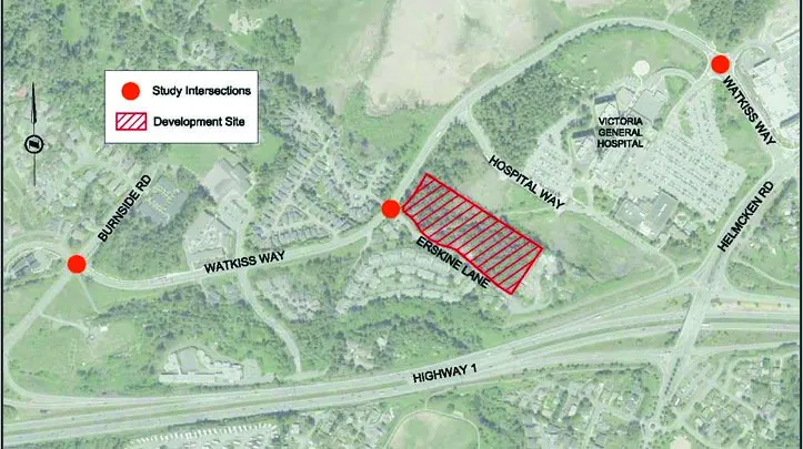
See Figure 1 for the study area and location. The study area includes the site accesses and following intersections:
- Watkiss Way / Erskine Lane / Stoneridge Drive
- Burnside Road W / Watkiss Way
- Watkiss Way / Hospital Access / Mall Access
- Watkiss Way / Chancellor Avenue / Helmcken Road
1.2 The Site Today
The site is currently undeveloped.
1.3 Proposed Development
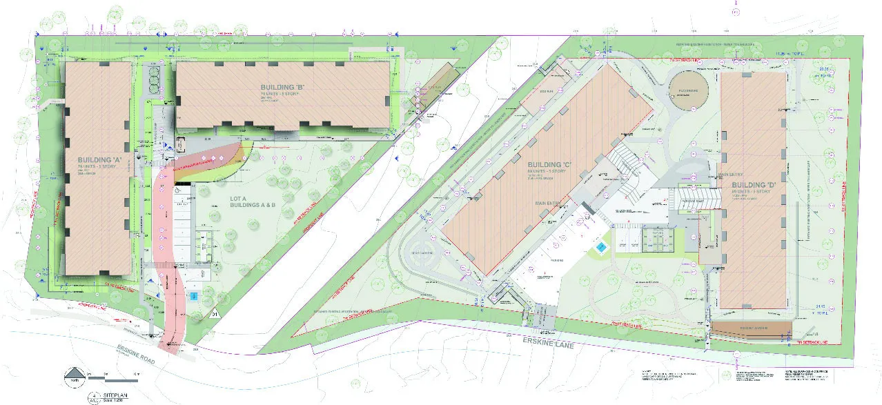
The proposed development will consist of four mid-rise buildings of 6 stories each containing 336 residential units between them and is expected to be completed by 2023. The site plan is shown in Figure 2.
1.4 This Report
This report is provided as part of the Zoning Bylaw Amendment application being submitted to the Town of View Royal. It provides the following:
- An overview of the existing and evolving transportation context in the vicinity of the site, including vehicular, pedestrian, cycling, and transit facilities.
- An overview of the proposed development programme.
- An assessment of the existing traffic activity patterns and volumes in the study area during the weekday morning and afternoon peak periods.
- A comprehensive review of the vehicular traffic volume changes that may occur in the area in the future with the construction of other area development projects.
- An assessment of the trip generation and assignment characteristics of the proposed development.
- A review of vehicular traffic operations at intersections in the area under existing and future conditions, including an assessment of the operational impacts of the proposed development.
2.0 TRANSPORTATION CONTEXT
2.1 Land Use
The proposed site was rezoned as CD 25 as part of the development process. There is an existing single-family home on the site. The surrounding land use is a mix of multi-family and single family residential along Erskine Lane and Stoneridge Drive, with the Victoria General Hospital to the east.
2.2 Road Network
2.2.1 Existing Road Network
Six key roads were identified within the study area:
- Watkiss Way is an undivided, two-lane, major road that runs east/west within the study area. There are bicycle lanes on both sides of the street and no parking allowed on either side of the street. The posted speed limit is 50 km/h.
- Burnside Road W is an undivided two-lane, collector road that runs north/south within the study area. There are no bicycle lanes in the vicinity of the site, although there are bicycle lanes between Kami Court and Watkiss Way. Parking is not allowed along the street, except for a portion of road on the south side of the street just west of Watkiss Way where there is parking in laybys. The posted speed limit is 50 km/h.
- Erskine Lane is an undivided, two-lane local road that runs north/south within the study area. There are no bicycle lanes, and no parking is allowed except east of 7 Erskine Lane on the north side of the road for permit holders. The posted speed limit is 30 km/h.
- Stoneridge Drive is an undivided, two-lane local road that runs north/south within the study area. There are no bicycle lanes, and there is limited parking in front of the houses further up the road. The posted speed limit is 30 km/h.
- Helmcken Road is an undivided major road that generally runs north/south within the study area. Helmcken Road has a variable cross-section ranging from 6 lanes south of Watkiss Way to 2 lanes north of Watkiss Way, with a combination of raised center median, dedicated left turn lanes and a two-way center-left-turn-lane that provides access to residential properties between Burnside Road and Watkiss Way / Chancellor Avenue. There are bicycle lanes on both sides of the street, and no parking. The posted speed limit is 50 km/h.
- Hospital Access / Mall Access is an undivided, two-lane local road that runs east / west within the study area. There are no bicycle lanes and no parking. The posted speed limit is 30 km/h.
Four key intersections were identified within the study area:
- Watkiss Way / Erskine Lane / Stoneridge Drive is a four-leg, stop-controlled intersection, although a change in traffic control to either a traffic signal or roundabout is planned to be constructed in the short term. The eastbound and westbound approaches on Watkiss Way are free flow, and the northbound and southbound approaches on Erskine Lane / Stoneridge Drive are stop-controlled.
- Watkiss Way / Burnside Road W is a four-legged signalized intersection. The northbound leg has a separate left / through lane and right turn lane, with the northbound left turn having protected / permitted phasing during the PM peak hour.
- Watkiss Way / Hospital Access / Mall Access is a single lane roundabout with a westbound-right by-pass from Watkiss Way into the Eagle Creek Village commercial development.
- Helmcken Road / Watkiss Way / Chancellor Avenue is a four-legged signalized intersection. Dedicated left turn lanes, including dual northbound lefts, are provided on all approaches to the intersection and the Helmcken Road southbound approach includes a channelized right turn island. The left turn movements on Helmcken Road have protected left turn phasing. The eastbound left turn movement (Watkiss Way onto Helmcken Road) has protected/permitted left turn phasing. The south leg of the Helmcken Road / Watkiss Way intersection is under the jurisdiction of the Ministry of Transportation and Infrastructure (MOTI).
2.2.2 Traffic Calming
Watkiss Way currently has approximately 5,000 vehicles per day on the corridor which by 2033 is projected to reach 8,000 vpd. At this level of volume, the roadway is operating near an arterial road level (from a collector road) or as the Transportation Master Plan states a Major Roadway. The higher the road classification (arterial is the highest) the more the focus is on the mobility of traffic over access and calming traffic (by reducing volumes).
Document Images
(3)