Attachment 3. Site Plan – Kilo Architecture Limited
Architectural plans including a site plan and building elevations for the proposed development at 81 High Street.
SUBDIVISION OF 81 HIGH ST.
81 HIGH ST. VIEW ROYAL, BC
3 NORTH ELEVATION 81 HIGH STREET
Scale: 1:100
[Drawing: Detailed north elevation of the building at 81 High Street showing facade dimensions, window placements, and materials]
Annotations:
- 82'-0" [24993.6] (Total width)
- 17.8 s.f. Glazed Door
- 656 S.F. EXPOSED FACE
- 8'-0" [2438] EXISTING 3' WALKWAY (TO BE REMOVED)
- 1'-5" [432]
- 5'-6" [1676]
- 110 S.F. EXPOSED FACE
- 20'-0" [6096]
- CONCRETE FOUNDATION
- 12 s.f. (3' x 4') Window
- **14.9 s.f. (3' x 4'-11.5") Window
LIMITING DISTANCE CALCULATION
North Elevation, 81 High Street
- TOTAL AREA OF EXPOSING BUILDING FACE: 766 S.F. = 71.16m²
- AREA OF UNPROTECTED OPENINGS: 92.3 s.f. = 8.57m²
- PERCENTAGE UNPROTECTED: (8.57m² / 71.16m²) = 12.0%
- Limiting Distance (by Extrapolation) = 2.41m
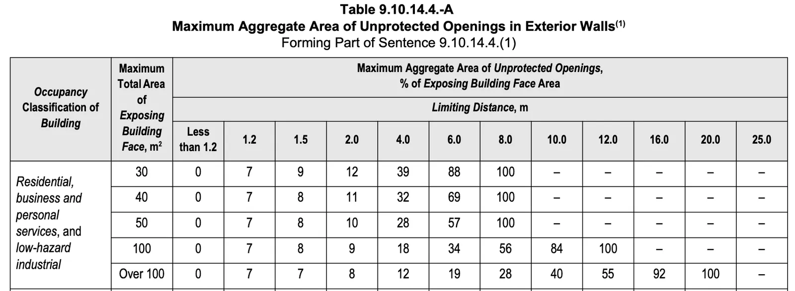
Table 9.10.14.4.-A: Maximum Aggregate Area of Unprotected Openings in Exterior Walls (1)
Forming Part of Sentence 9.10.14.4.(1)
| Occupancy Classification of Building | Maximum Total Area of Exposing Building Face, m² | Less than 1.2 | 1.2 | 1.5 | 2.0 | 4.0 | 6.0 | 8.0 | 10.0 | 12.0 | 16.0 | 20.0 | 25.0 |
|---|---|---|---|---|---|---|---|---|---|---|---|---|---|
| Residential, business and personal services, and low-hazard industrial | 30 | 0 | 7 | 9 | 12 | 39 | 88 | 100 | — | — | — | — | — |
| 40 | 0 | 7 | 8 | 11 | 32 | 69 | 100 | — | — | — | — | — | |
| 50 | 0 | 7 | 8 | 10 | 28 | 57 | 100 | — | — | — | — | — | |
| 100 | 0 | 7 | 8 | 9 | 18 | 34 | 56 | 84 | 100 | — | — | — | |
| Over 100 | 0 | 7 | 7 | 8 | 12 | 19 | 28 | 40 | 55 | 92 | 100 | — |
(Note: Red annotations on the drawing indicate calculations for a 71.16m² face and 12.0% openings, resulting in a 2.41m limiting distance.)
ZONING INFORMATION
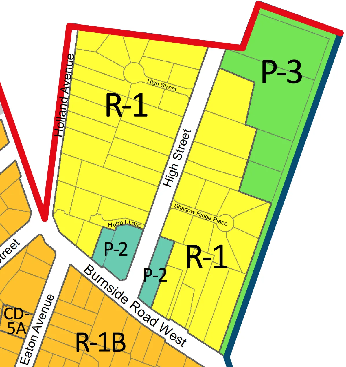
EXISTING ZONING: R-1 DETACHED RESIDENTIAL (LARGE LOT)
6.1.4. Lot Size, Lot Coverage, Building Height and Setbacks
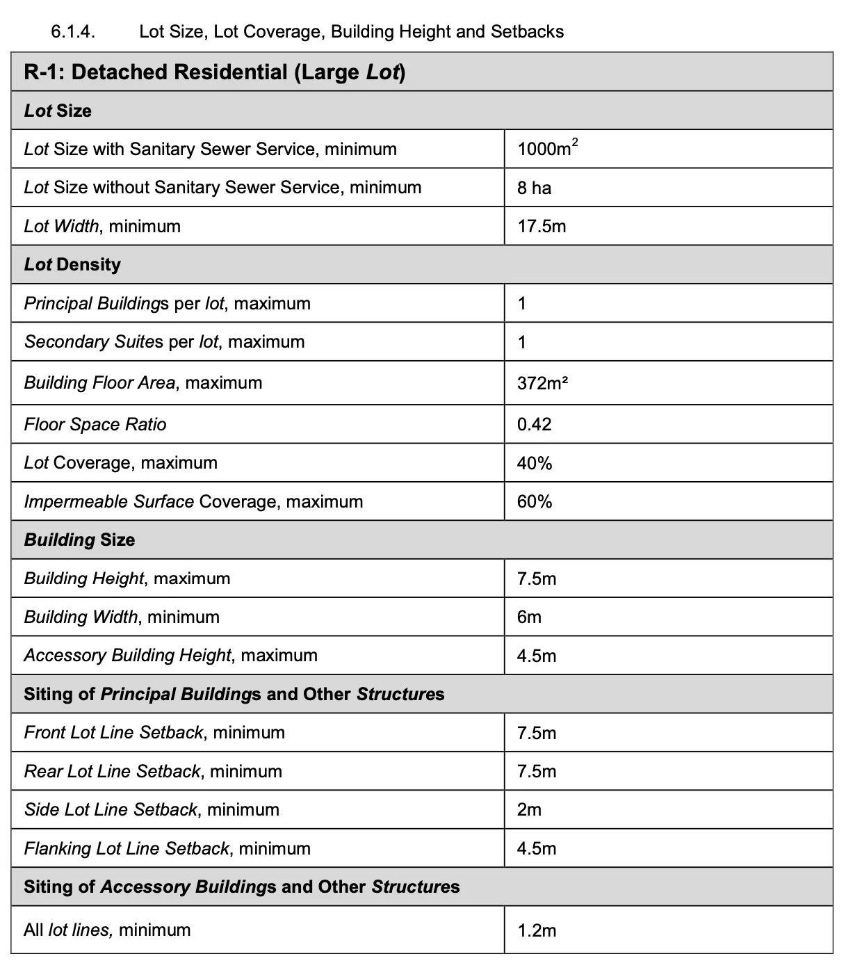
| R-1: Detached Residential (Large Lot) | |
|---|---|
| Lot Size | |
| Lot Size with Sanitary Sewer Service, minimum | 1000m² |
| Lot Size without Sanitary Sewer Service, minimum | 8 ha |
| Lot Width, minimum | 17.5m |
| Lot Density | |
| Principal Buildings per lot, maximum | 1 |
| Secondary Suites per lot, maximum | 1 |
| Building Floor Area, maximum | 372m² |
| Floor Space Ratio | 0.42 |
| Lot Coverage, maximum | 40% |
| Impermeable Surface Coverage, maximum | 60% |
| Building Size | |
| Building Height, maximum | 7.5m |
| Building Width, minimum | 6m |
| Accessory Building Height, maximum | 4.5m |
| Siting of Principal Buildings and Other Structures | |
| Front Lot Line Setback, minimum | 7.5m |
| Rear Lot Line Setback, minimum | 7.5m |
| Side Lot Line Setback, minimum | 2m |
| Flanking Lot Line Setback, minimum | 4.5m |
| Siting of Accessory Buildings and Other Structures | |
| All lot lines, minimum | 1.2m |
Topographic Site Plan Of:
Lot A, Section 9, Esquimalt District, And Of Section 16, Victoria District (Situated In Esquimalt District), Plan VIP79746. P.I.D. 026-454-661
Scale = 1:200
- Dated this 11th day of December, 2017.
- Distances and elevations shown are in metres.
- Elevations are based on assumed datum.
- This site plan is for building and design purposes and is for the exclusive use of our client.
- This document shows the relative location of the surveyed structures and features with respect to the boundaries of the parcel described above. This document shall not be used to define property lines or property corners.
2 81 High St Subdivision Site Plan
Scale: 1:100 [Drawing: Enlarged site plan detail showing proposed property lines, setbacks, and no-build covenant lines]
Key Annotations:
- 3.3m NO BUILD COVENANT LINE
- 2m SIDE YARD SETBACK LINE
- PROPOSED NEW PROPERTY LINE
- PROPOSED 1.66m SIDE YARD SETBACK LINE (VARIANCE)
- 2m SIDE YARD SETBACK LINE
- EXISTING PROPERTY LINE AS SURVEYED 2013
- 2m SIDE YARD SETBACK LINE
- PROPOSED 0.7m SETBACK (VARIANCE)
- 24'-7 1/4" [7500] FRONT YARD SETBACK
- 13'-1 1/2" [4000]
- 10'-9 7/8" [3300]
- 2'-4 3/4" [730]
- 6'-6 3/4" [2000]
- 2'-3 1/2" [700]
- CORNER OF HOUSE 7.34m FROM PROPOSED PROPERTY LINE
- PROPOSED NEW PROPERTY LINE
- 38'-6" [11734]
- VIOLATION OF 2m SIDE YARD SETBACK
- 2.41m LIMITING DISTANCE
- 3.3m NO BUILD COVENANT LINE REGISTERED ON PROPERTY TO MAINTAIN 4.5m MINIMUM BETWEEN BUILDINGS
1 81 High St Subdivision Site Plan
Scale: 1:200 [Drawing: Overall subdivision site plan showing Lot A, Plan 79746, neighboring Plan 78997 and Plan 5296, and the adjacent Park area]
Key Features:
- High Street
- Shadow Ridge Place
- Burnside Road West
- Lot A Plan 79746 (Area=1246.5m²)
- EXISTING HOUSE AND LOT
- PROPOSED NEW LOT
- Park
- Shed
Project Information
Architect: KILO Architecture Inc. 1412-450 Simcoe St Victoria BC 250 896 9678 info@kiloarchitecture.com
Land Surveyor: Wey Mayenburg Land Surveying Inc. www.weysurveys.com #4-2227 James White Boulevard Sidney, BC V8L 1Z5 Telephone (250) 656-5155 File: 170411PROUGH
| Project Manager: | KAT |
|---|---|
| Project Date: | January 2023 |
| Drawn By: | KAT |
| Project Number: | 1750 |
| Sheet Title: | SITE PLAN |
| Sheet No: | A1 of 1 |
Document Images
(1)