ATTACHMENT 1: COMMITTEE OF THE WHOLE REPORT - 297 View Royal Ave Slope Stabilization
A secondary report from December 2022 providing background on the slope stabilization project and the initial introduction of the variance request.
TOWN OF VIEW ROYAL COMMITTEE OF THE WHOLE REPORT
TO: Committee of the Whole DATE: December 5, 2022 FROM: Stirling Scory, RPP, MCIP, Community Planner MEETING DATE: December 13, 2022
Environmental Development Permit with Variance 2022-08, 297 View Royal Ave Slope Stabilization
RECOMMENDATION:
THAT the report dated December 5, 2022 from the Community Planner titled “Environmental Development Permit with Variance 2022-08, 297 View Royal Avenue – Slope Stabilization” be received for information.
CHIEF ADMINISTRATIVE OFFICER’S COMMENTS: I concur with the recommendation.
DIRECTOR OF DEVELOPMENT SERVICES’S COMMENTS: I concur with the recommendation.
DIRECTOR OF ENGINEERING’S COMMENTS: I concur with the recommendation.
PURPOSE OF REPORT:
The purpose of this report is to present a new application for an Environmental Development Permit to permit the stabilization of a bank at the property located at 297 View Royal Avenue.
BACKGROUND:
The 635 m² waterfront property is situated at the head of Lime Kiln Cove within the Esquimalt Harbour and is located within the Town’s Harbour Neighbourhood. The property within the Environmental Development Permit Area – Natural Watercourse and Shoreline Areas, is designated R-L (Large Lot Residential) in the Official Community Plan (OCP), and zoned R-1 Detached Residential (Large Lot). The surrounding properties share the same land use designation and zoning. A site plan for the subject property may be reviewed below, see Figure 1.
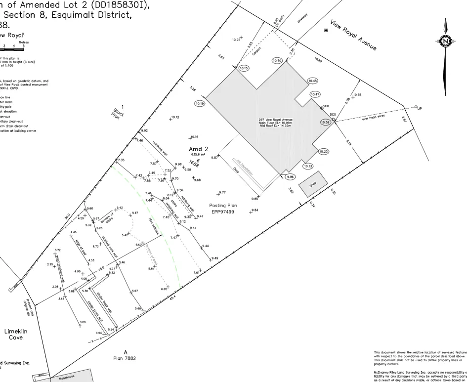
Figure 1 - Site Plan
The Natural Watercourse and Shoreline Area Development Permit Area identified in the Town’s OCP was established to ensure that ecologically important areas were considered prior to development, and that measures would be taken to control and avoid potential damages to the ecosystem as a result.
The property has an existing house and patio, as well as hard landscaping features in the rear yard that include retaining walls, a path, and stairs that go down to the waterfront, see Figures 2 and 3 for reference below. There are two different types of retaining features on the property, some are made of wood and others are made of concrete. Those made of wood have failed, which has resulted in the loss of stability of the slope that is used to access the waterfront. The intent of the proposal is to stabilize the slope and provide safe access to the waterfront; the proposed works should also rectify the ongoing slope destabilization.
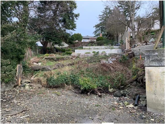
Figure 2 - Site Context (from foreshore looking upland)
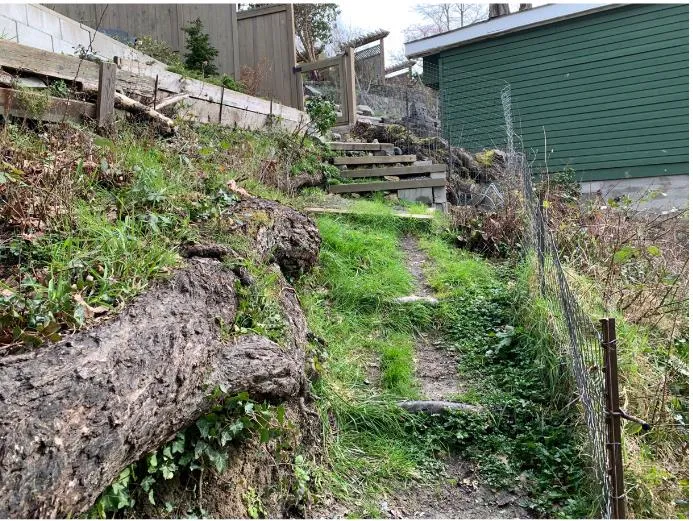
Figure 3 - Existing slope conditions and pathway
PROJECT INFORMATION
The applicant is proposing to remove existing retaining walls, stairs and pathway features and vegetation in the upland area. The proposed works would include new vegetated gabion walls, FlexMSE retaining walls, and landscape walls in the upland area, along with new stairs, fine gravel pathway, and pavers used for stairs (Attachments 4, 5 and 6 and refer to Figure 4 below). All works will be conducted upslope of the present natural boundary. The work would be completed using hand tools, a small excavator, and bobcat, and other works as specified by the arborist in their report (Attachment 7). The applicant has proposed that work be completed between July 1 and October 1st to comply with the “Reduced Risk Fisheries Window” for marine shorelines.
In support of their application, the applicant has provided the following supporting documents:
- Letter to Mayor and Council
- Site Plan
- Landscape Plan
- Environmental Report (Swell Consulting) – September 13, 2022
- Geotechnical Study (Ryzuk Geotechnical) – March 25, 2022
- Arborists Report (Concrete Jungle Forestry Ltd.) – July 12, 2022.
DISCUSSION:
Landscaping and Tree Protection
The proposed development would look to adjust existing grade, and remove existing vegetation, including a mix of non-native, ornamental, and ‘weedy’ species as identified by the environmental report and arborist’s report provided by the applicant. The proposed development area also contains a Grand fir. The arborist report states that the tree is in good health; and that the tree will be retained with protective measures.
The arborist’s report also identifies that 299 View Royal Avenue (property to the west) has an Oak tree (Quercus sp.) and Black hawthorn tree and their critical root zones are in the proposed area of development. The trees are in good health and the arborist confirms that the trees are to be retained with protective measures. In addition, 295 View Royal Avenue (property to the east) contains a Bigleaf maple and its critical root zone in the proposed area of development. The tree is healthy and the arborist confirms that the tree will be retained with protective measures. The arborist will be onsite during construction activities to monitor the proposed works. The applicant will be required to obtain a tree permit prior to the commencement of any works.
The concept landscape plan provided, refer to Figure 4 below, shows the location of the trees and the proposed structures and landscaping features.
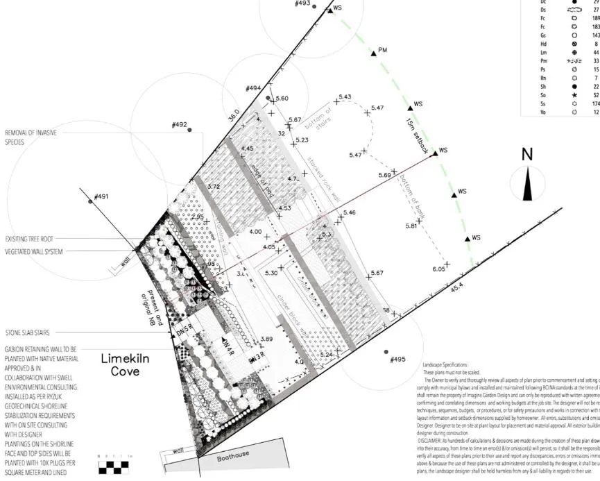
Figure 4 - Conceptual Landscape Plan
Details of the proposed works can be reviewed in Figure 5, a cross section of the rear yard of the property; however, further details on the siting of the FlexMSE vegetated wall should be provided, with respect to spacing. Details on the retaining walls will be confirmed by the applicant prior to consideration of the Development Permit to ensure the proposal is compliant with the Town’s Zoning Bylaw.
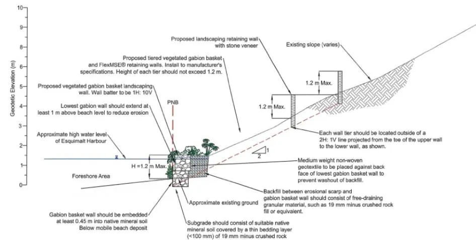
Figure 5 - Retaining Wall Cross Section
Environment and Marine Area
Within the marine shoreline area, it has been observed that the adjacent properties are bracketed with concrete seawalls that extend into the beach area and are used to retain and protect the shoreline properties. The subject property’s slope and present natural boundary are set back further than the neighbouring properties. The upper beach area (closest to shoreline) is devoid of any marine vegetation, apart from some lyngby sedge (grass) that grows amongst the pilings. The site inspection did not reveal any listed environmentally sensitive ecosystems, red (endangered/threat of loss) or blue (special concern) listed species, or any significant environmental features. The study did not include a wildlife survey; however, common west-coast species were observed (raccoons, waterfowl, Columbia Black Tailed Deer). No bird nesting activity was observed. It is believed that the subject property and foreshore area do not contain any vital organisms or species, based on the report provided by Swell Consulting.
Geotechnical Review
The geotechnical report provided by Ryzuk Geotechnical observes that the slope looks to be stable; however, the report notes that there are signs of surface soil loss and erosion at the toe of the slope above the foreshore area (upland of the of present natural boundary). The report details that the expectation of continued surface soil loss and erosion will continue and is expected to do so at an increased rate due to the anticipated impacts of sea level rise. Ongoing erosion is expected to result in small scale soil slumps and a gradual regression of the slope crest. The report stated the work could be constructed without adversely impacting slope stability or erosion on the subject property or the neighbouring properties.
The proposal looks to remove the existing cinder block walls and install new FlexMSE vegetation and gabion retaining walls. All works will need to be designed to the specifications and reviewed to the satisfaction of the geotechnical engineer and their report, see attachment 6.
Development Permit Areas
The application is found to meet the following Natural Watercourse and Shoreline Areas Development Permit Area Guidelines contained within the OCP:
- development is contained upland of the present natural boundary
- the proposal looks to remove non-native plant species and plants a mix of native plant species to revegetate the area
- the development does not look to adversely impact or affect existing habitat for marine vegetation or organisms, or terrestrial species, including birds
- the proposal will stabilize a destabilized slope
- the proposal avoids the use of the most extreme hard engineered surfaces to stabilize the slope, and uses gabions and FlexMSE vegetated wall system (a high-mid tier feature as identified in the OCP)
- the foreshore area of the subject property does not contain any red or blue listed species
- the proposed works have been reviewed by and will be carried out under the supervision of a qualified environmental professional, certified arborist, and geotechnical engineer.
Zoning Bylaw Review
The applicant’s proposal includes the addition of retaining walls within 15 m of the natural boundary of the sea (present natural boundary). The proposed works will require a variance, per Section 3.8.2 of Zoning Bylaw No. 900, 2014.
Department of National Defense
The applicant is required to provide an application to the Department of National Defense (DND) for this application, as the proposed works are located within Esquimalt Harbour. The DND has been notified and will review and comment on the application. Additionally, staff are waiting for comments from the Department of Fisheries and Oceans.
NEXT STEPS:
Prior to consideration of the proposal by Council, staff will continue to work with the applicant to confirm and receive the following information:
- department of National Defense comments and review
- department of Fisheries and Oceans
- landscaping details (impermeable surface and landscape cost estimate)
- retaining wall details (building permit requirement and determine compliance with the Zoning Bylaw or if a variance will be required).
RECOMMENDATION:
THAT the report dated December 5, 2022 from the Community Planner titled “Environmental Development Permit with Variance 2022-08, 297 View Royal Avenue – Slope Stabilization” be received for information.
SUBMITTED BY: Stirling Scory, RPP, MCIP Community Planner
REVIEWED BY: Leanne Taylor, Director of Development Services RPP, MCIP
Attachments:
- Subject Property Map
- Letter to Mayor and Council
- Site Plan
- Landscape Plan (Imagine Garden Design) – May 18, 2022
- Environmental Report (Swell Consulting) – September 13, 2022
- Geotechnical Study (Ryzuk Geotechnical) – March 25, 2022
- Arborists Report (Concrete Jungle Forestry Ltd.) – July 12, 2022
Document Images
(4)