Proposed Foreshore Stabilization Works - 297 View Royal Avenue
Geotechnical assessment and engineering design for shoreline stabilization, recommending the use of vegetated gabion basket walls to mitigate erosion.
Ryzuk Geotechnical
Engineering & Materials Testing
March 25, 2022
File No: 9693-1
Leanne Howes
297 View Royal Avenue
View Royal, BC
V9B 1B3
(By E-mail: leanne.howes@telus.net)
Re: Proposed Foreshore Stabilization Works
297 View Royal Avenue – View Royal, BC
As requested, we attended the referenced waterfront property to complete a visual geotechnical assessment as such relates to the stability of the seaward facing slope above the foreshore area. The site is located within the Environmental Protection & Natural Hazard Development Permit Area, in accordance with the View Royal Official Community Plan. Our associated observations, comments, and recommendations in this regard are summarized herein. Our work has been carried out in accordance with, and is subject to, the previously accepted Terms of Engagement.
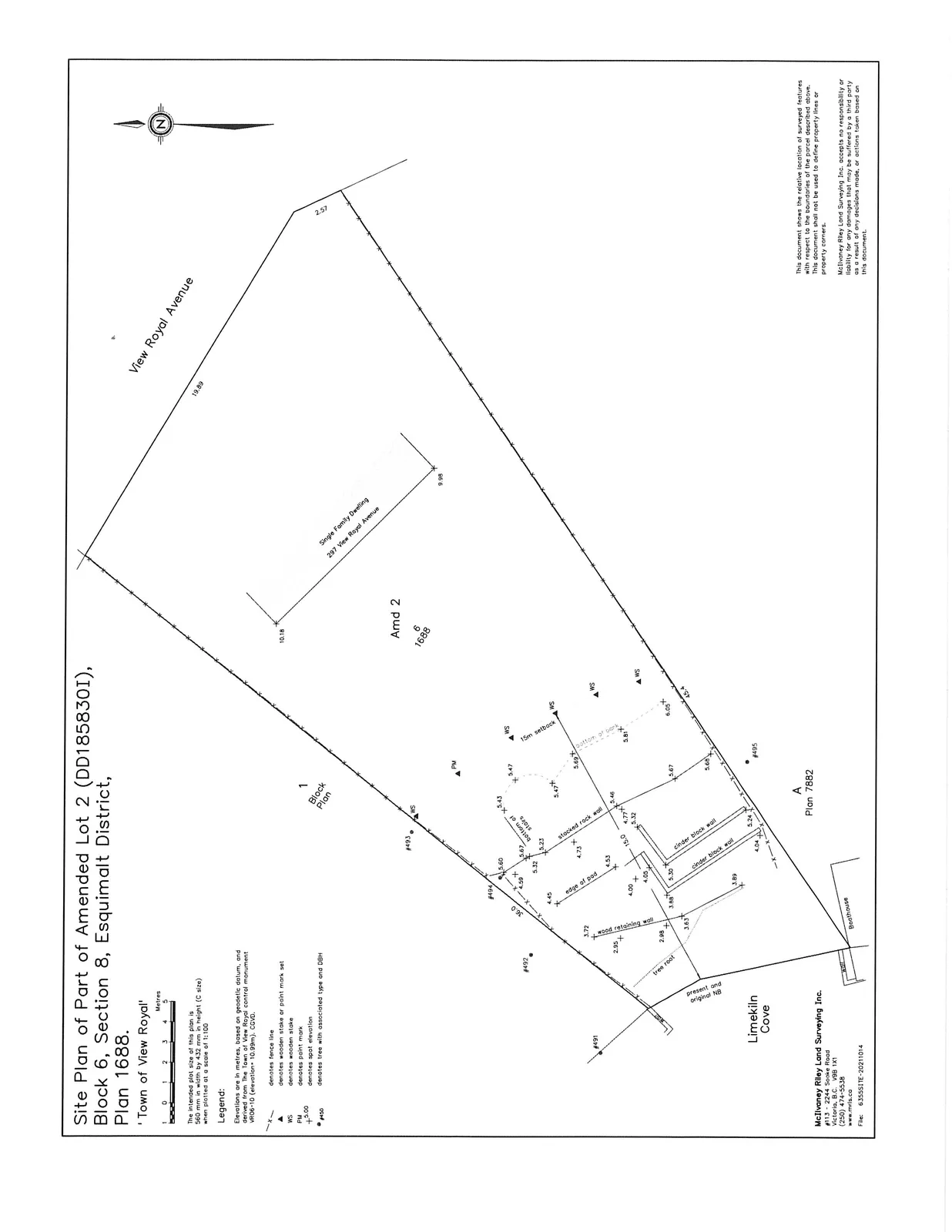
The site is a roughly wedge shaped waterfront lot, which is bounded by View Royal Avenue to the northeast, neighbouring residential properties to the northwest and southeast, and the marine foreshore of Limekiln Cove (Esquimalt Harbour) to the southwest. See attached Site Plan by McIlvaney Riley Land Surveying Inc.
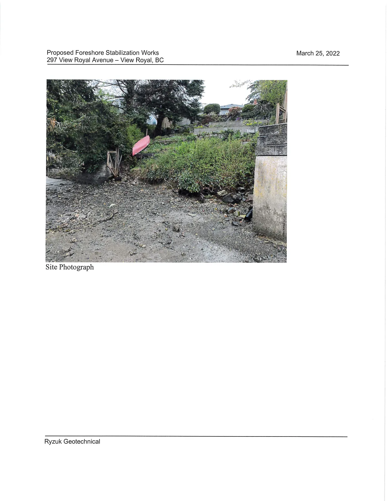
Grade over the northeastern third of the property is relatively flat and at/near that of View Royal Avenue. This part of the property is occupied by the existing dwelling. Beyond to the southwest, the property slopes down to the foreshore area at around 20° or so (locally steeper in places) with overall vertical relief of around 9 m. The slope has been landscaped and incorporates low height landscaping walls of various types and a switchback beach access path. A 1 m high near vertical scarp of very stiff brown silty clay mineral soil is present at the base of the slope. The beach consists of finer sediments as well as gravel/cobbles with outcropping bedrock observed in the intertidal zone. Historical cast in place concrete seawalls armour the base of the slope on both neighbouring properties. We noted the soil scarp on the subject property was set back approximately 1.2 m from the face of the adjacent concrete seawalls and likely defines the Present Natural Boundary (PNB), see attached Site Photograph. The frontage of the slope as measured between the adjacent concrete seawalls is approximately 10 m. Seepage was emanating from the base of the slope, possibly from perched surface water migrating down through the surficial organic soils atop the less permeable native clays. Vegetation consists of sporadic property line tree presence and low height ground cover, including ornamental shrubbery, horsetail, and English ivy.
On the basis of our observations, it appears that the slope is largely stable under static conditions. This would be expected given the relatively benign grading of the slope and our experience in the area (including our site observations), which indicate that materials within the slope comprise of a very stiff/hard brown silty clay atop intermittent veneer of glacial till then bedrock.
We observed indication of minor creep within the surficial soils of the slope and erosion at the toe of the slope. Soil creep on sloping terrain is commonplace and describes the gradual downslope movement of the surface soils. The rate of creep can be influenced by a number of factors. In this case, we expect that perched surface water migrating downslope to the foreshore likely contributes to creep.
At the toe of the slope, above the foreshore area, both the current position of the slope toe relative to armouring on adjacent properties as well as the exposed mineral soils are indicative of ongoing erosion. We expect that upslope seepage and periodic wave action during high tide storm events likely contribute to the toe erosion. Limekiln Cove appears well protected from extreme weather events. That being said, in the long term we would expect that toe erosion would continue, the rate of such possibly increasing due to anticipated sea level rise that would result in more frequent wave wash at the slope toe. On going toe erosion will result in episodic small scale soil slumps and gradual regression of the slope crest.
We understand that it is proposed to redo the landscaping/vegetation on the slope and place an armouring feature at the toe of the slope to mitigate future erosion. Existing trees will be retained where possible. We recommend that proposed works balance cuts and fills and avoid substantial additional loading on the existing slope. This would avoid accelerating the rate of shallow creep and unduly influencing slope stability. Based on our discussions, the slope grading will remain similar in some areas and be re-tiered in others. Tiered landscaping walls, where proposed, should be located such that the upper tier is set back behind a minimum 2H to 1V plane extending from the base of the lower wall, so as not to induce a surcharge on the lower wall. The noted walls are intended as landscaping walls only and would not be designed for support of any structure. Use of flexible tier systems such as boulders or bags should be considered as such can readily accommodate minor movement without unsightly cracking that could occur with concrete, masonry, or blocks.
We are aware that Soft Shore/Green Shores stabilization techniques are favoured by the local municipalities. We consider this to be feasible given the anticipated low energy erosional regime experienced in Limekiln Cove. The existing exposed soil scarp could readily be protected by placement of gabion baskets in front of the scarp. Gabion (rock filled) basket walls are an option that would protect the slope by providing resistance to wave erosion, provide surface roughness similar to the existing bedrock beach outcrop (rather than the smooth/hard finish of concrete block or cast in place), allow vegetative growth in interstices, and are relatively simple and economical to construct.
The baskets should be founded on suitable bearing soils (likely native clay) below the mobile beach deposit. We recommend at least 450 mm of basket embedment to key-in and mitigate concerns relating to future wave wash undermining the baskets. The baskets would extend at least 1 m above the beach to offer protection to the exposed soil scarp. We recommend placement of a medium weight non-woven filter fabric against the back of the baskets to prevent tidal action/wave wash from pulling out finer granular backfill through the baskets. Backfill between the scarp and baskets should consist of a well graded free draining granular fill such as a 19 mm minus crushed rock. The baskets will extend laterally to contact the neighbouring concrete walls and be positioned at/near the current alignment of the slope toe (PNB). It would be feasible/acceptable to incorporate a beach access stair within the basket arrangement.
No significant changes to the existing stormwater regime are anticipated as a result of the work. It would be possible to direct foundation and roof drainage to the foreshore area provided such can be completed in a fashion that prevents erosion on the slope or in the foreshore area. This could be accomplished by tight piping flows to the bottom of the slope for discharge upon a localized rock splash pad positioned to the rear of one of the baskets.
Based on the above, and provided our recommendations are followed, we consider the construction of the noted works can be completed without adverse impacts to slope stability or erosion on this or neighbouring properties. In working in and around the foreshore area, it will be necessary to adhere to DFO Standards and Codes of Practice.
We trust the preceding is suitable for your purposes at present. If you have any questions, or require anything further, please do not hesitate to contact us.
Yours truly,
Ryzuk Geotechnical
Scott Currie, P.Eng.
Geotechnical Engineer
Attachments:
- McIlvaney Riley Land Surveying Inc. Site Plan
- Site Photograph
Proposed Foreshore Stabilization
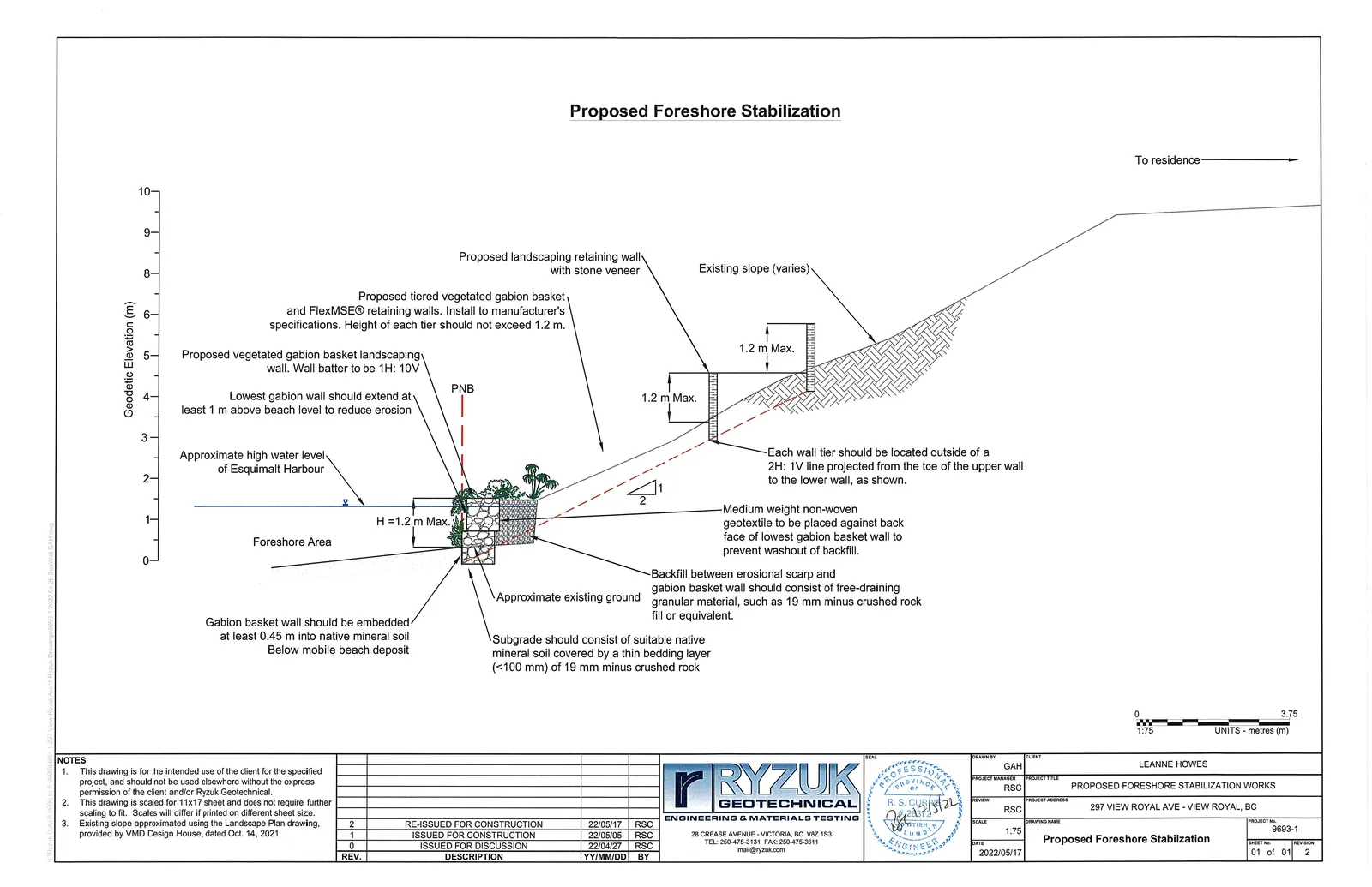
Drawing Notes:
- This drawing is for the intended use of the client for the specified project, and should not be used elsewhere without the express permission of the client and/or Ryzuk Geotechnical.
- This drawing is scaled for 11x17 sheet and does not require further scaling to fit. Scales will differ if printed on different sheet size.
- Existing slope approximated using the Landscape Plan drawing, provided by VMD Design House, dated Oct. 14, 2021.
Revision History:
| REV. | DESCRIPTION | YY/MM/DD | BY |
|---|---|---|---|
| 2 | RE-ISSUED FOR CONSTRUCTION | 22/05/17 | RSC |
| 1 | ISSUED FOR CONSTRUCTION | 22/05/05 | RSC |
| 0 | ISSUED FOR DISCUSSION | 22/04/27 | RSC |
Project Information:
- Client: LEANNE HOWES
- Project Title: PROPOSED FORESHORE STABILIZATION WORKS
- Project Address: 297 VIEW ROYAL AVE - VIEW ROYAL, BC
- Drawing Name: Proposed Foreshore Stabilization
- Project No: 9693-1
- Sheet No: 01 of 01
- Date: 2022/05/17
- Scale: 1:75
- Units: metres (m)
Document Images
(3)