Appendix
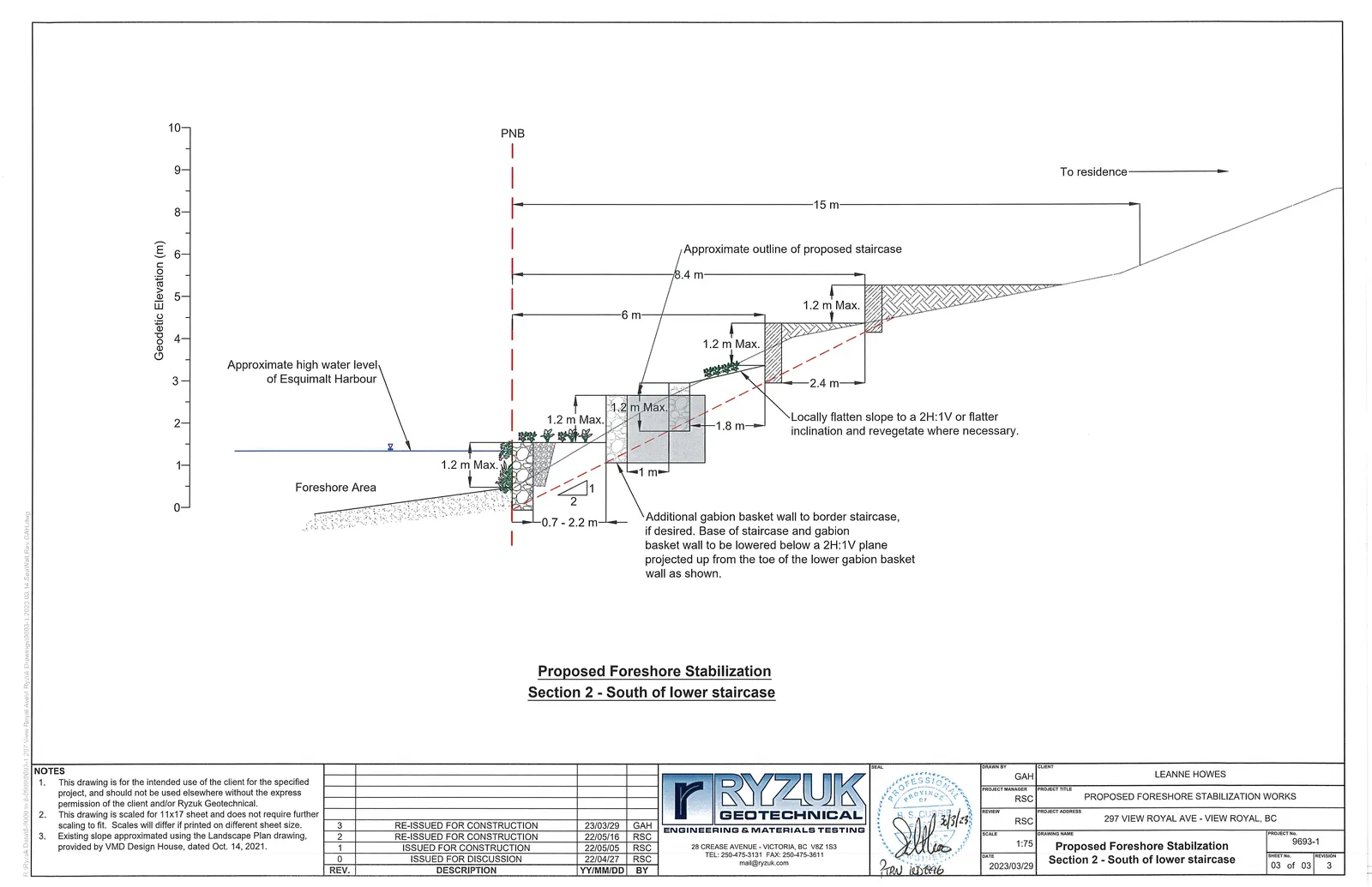
Proposed Foreshore Stabilization Section 2 - South of lower staircase
June 6, 2023Page 1771 section
Cross-section diagram illustrating the southern portion of the proposed stabilization works, including staircase details and wall heights.
297 View Royal AvenueMarch 28, 20231.2 m Max wall height
Proposed Foreshore Stabilization Section 2 - South of lower staircase
Notes
- This drawing is for the intended use of the client for the specified project, and should not be used elsewhere without the express permission of the client and/or Ryzuk Geotechnical.
- This drawing is scaled for 11x17 sheet and does not require further scaling to fit. Scales will differ if printed on different sheet size.
- Existing slope approximated using the Landscape Plan drawing, provided by VMD Design House, dated Oct. 14, 2021.
Revision History
| REV. | DESCRIPTION | YY/MM/DD | BY |
|---|---|---|---|
| 3 | RE-ISSUED FOR CONSTRUCTION | 23/03/29 | GAH |
| 2 | RE-ISSUED FOR CONSTRUCTION | 22/05/16 | RSC |
| 1 | ISSUED FOR CONSTRUCTION | 22/05/05 | RSC |
| 0 | ISSUED FOR DISCUSSION | 22/04/27 | RSC |
Project Information
RYZUK GEOTECHNICAL ENGINEERING & MATERIALS TESTING 28 CREASE AVENUE - VICTORIA, BC V8Z 1S3 TEL: 250-475-3131 FAX: 250-475-3611 mail@ryzuk.com
| Field | Detail |
|---|---|
| DRAWN BY | GAH |
| CLIENT | LEANNE HOWES |
| PROJECT MANAGER | RSC |
| PROJECT TITLE | PROPOSED FORESHORE STABILIZATION WORKS |
| REVIEW | RSC |
| PROJECT ADDRESS | 297 VIEW ROYAL AVE - VIEW ROYAL, BC |
| SCALE | 1:75 |
| DRAWING NAME | Proposed Foreshore Stablization Section 2 - South of lower staircase |
| DATE | 2023/03/29 |
| PROJECT No. | 9693-1 |
| SHEET No. | 03 of 03 |
| REVISION | 3 |
Diagram Details and Annotations
- Geodetic Elevation (m): Vertical scale from 0 to 10.
- PNB: Property line marker.
- Approximate high water level of Esquimalt Harbour: Indicated at approximately the 1.6m elevation.
- Foreshore Area: Area below the high water mark.
- Staircase Details:
- Approximate outline of proposed staircase is shown.
- Horizontal distances indicated: 6 m, 8.4 m, and 15 m to residence.
- Stabilization Structures:
- Gabion baskets labeled with "1.2 m Max." height.
- Base widths and positioning noted as 0.7 - 2.2 m and 1 m.
- "Additional gabion basket wall to border staircase, if desired. Base of staircase and gabion basket wall to be lowered below a 2H:1V plane projected up from the toe of the lower gabion basket wall as shown."
- Slope and Vegetation:
- "Locally flatten slope to a 2H:1V or flatter inclination and revegetate where necessary."
- Dimensions of 1.8 m and 2.4 m related to slope tiers.
Page 177
Extracted from: 2023 06 06 Council Agenda - Agenda - Pdf